

Article Title :
Estimation of Surface Soil Moisture from Agricultural Lands Using Multi-Spectral Optical Satellite Data: A Study of Bhagwanpur-I CD Block, East Medinipur, West Bengal, India 
7 (2023)
1-20
TVDI , Surface Soil Moisture , NDVI , Land surface temperature


The spatiotemporal fluctuation of Surface Soil Moisture (SSM) is important for prediction of weather, modeling of hydrological cycle, water management, agricultural managing and making strategy. Optical remote sensing has demonstrated significant promise for precise surface soil moisture estimate. The study aimed to estimate the moisture content in the upper layer of agricultural fields using Landsat 8 OLI, Sentinel-2A multi-spectral satellite data as well as TVDI [Temperature Vegetation Dryness Index] data. The spatial resolution of the Landsat OLI and Sentinel-2A images was 30m and 10m, respectively. The spectral Thermal Infrared (TIR 10.9µm ), TIR (10.9µm) and along with the Short-Wave-Infrared (SWIR 2.2µm) band of the Landsat 8 and the Shore-Wave-Infrared (SWIR 2.2 µm) band of sentinel 2B satellite imagery was utilized to estimate how moist was topsoil of the agricultural lands. The soil moisture estimates using remote sensing based model were acquired and compared with in-situ soil moisture. In a depth of 10cm below the surface, the field-based soil moisture was measured. Normalized Difference Vegetation Index (NDVI), Land Surface Temperature (LST) and TVDI were measured to estimate moisture content. The reflectance values of the TVDI show over the study area generally low, with the values ranging from -0.07 to 1.37. The statistical tests of TVDI values and gravimetric soil moisture values presented a positive correlation with RMSE= 0.17. The results of the study can give insight of better hydrological modeling, management of agriculture and policy making. However, further research is required to validate the methodology over a larger geographical area and to evaluate the preciseness of the assessed SSM at various depths of the soil.
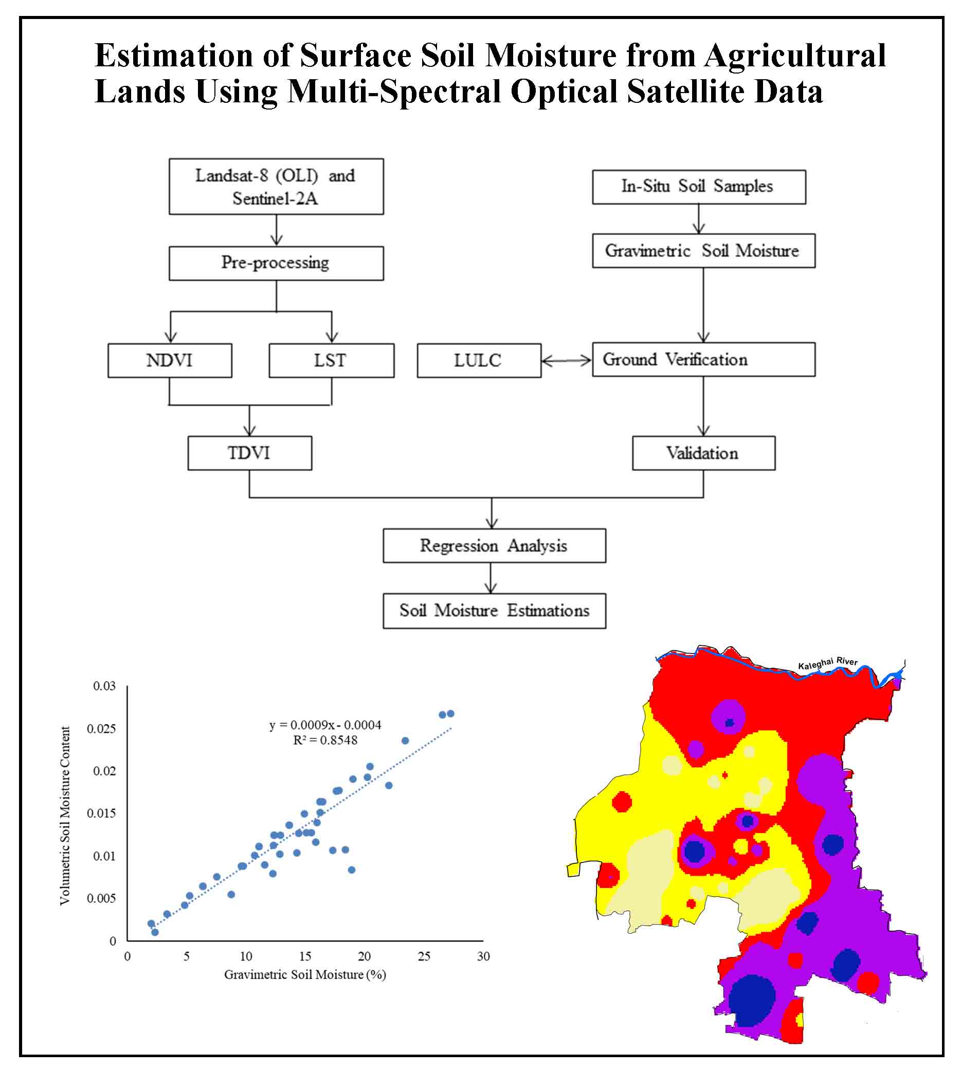
The Gravimetric method is used for measuring soil moisture content.
TVDI uses optical datasets to assess surface soil moisture content.
Bhagwanpur-I is a rural area with dense population and agriculture-based activities.
The collected data compared with model-based soil moisture and in-situ soil moisture.
Surface soil moisture content theatres a crucial character in the hydrological techniques.
Anguela, T., P., Zribi, M., Hasenauer, S., Habets, F., and Loumagne, C., 2008. Analysis of surface and root soil moisture dynamics with ERS scatter meter and hydrometriological model SAFRAN-ISBAMODCOU at grand Morin watershed (France). Hydro. EarthSystem. Science, 5, 1903-1926.
Batlivala, P. P. and Ulaby, F. T., 1977. Feasibility of monitoring soil moisture using active microwave remote sensing. Remote Sensing Laboratory, Tech. Rep., 264-12, University of Kansas, Lawrence.
Das, K. and Paul P. K., 2015. Present status of soil moisture estimation by microwave remote sensing. Cogent Geoscience,1, 1,
Maiti, S. K. and Basak, B. B., 2013. Soil moisture regimes and their classification for crop planning in parts of Paschim Medinipur district of West Bengal. Journal of Crop and Weed, 9(2), 89-93.
Mandal, S. and Roy T., 2019. Evolution and Trend of Settlement Pattern Associate with General Physiography in Bhagwanpur-I CD Block. Thematics Journal of Geography, 8(4).
Srivastava, H. S., Sharma, P. K., Kumar, D., Sivankar, T., Mishra, R. S., Mishra, M. Andpatel, P., 2015. Soil Moisture Variation over the parts of Saharanpur and Haridwar districts (India) during November-2006 to June-2007 as observed by multi-polarized (VV/VH and VV/VH) ENVISAT-I temporal ASAR data. International Journal of Advanced Engineering Research and Science (IJAERS), 2(1), 31-39.
