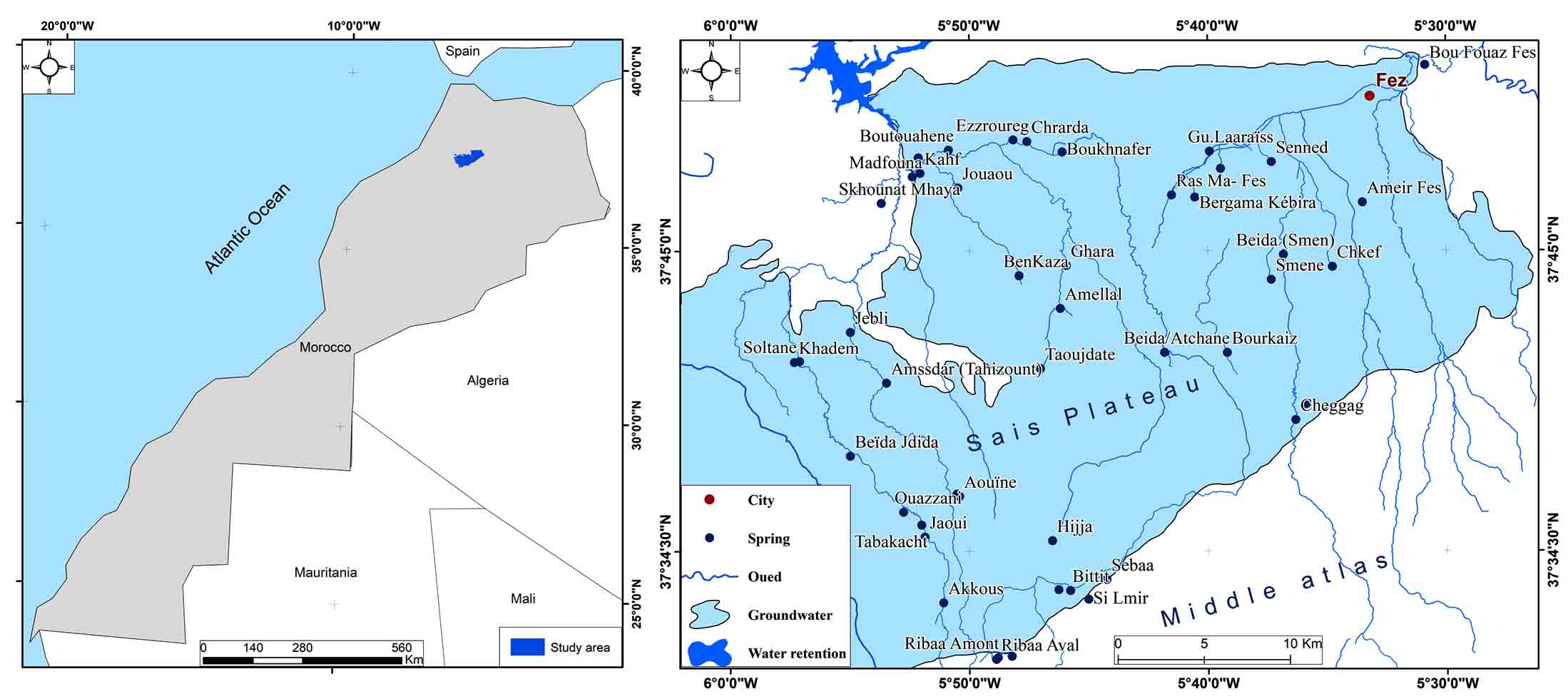
2 . GEOGRAPHIC AND HYDROGEOLOGICAL CONTEXT OF THE SPRINGS
The Saïs plateau is very rich in surface water and groundwater, this richness is mainly due to the geological complexity in this geographical space. In the latter, an intrinsic relationship is established between the structure of aquifers, subsurface drainage, the degree of karstification and the hydrological response of springs (Mangin, 1984). As a result, the majority of the springs characterizing the plain of Fez and its middle Atlas borders are the origin of the water infiltrated at the level of the Middle Atlas (Qadem, 2020; Figure 1).
These springs studied are linked to the carbonate formations of Lias, with the exception of a few springs belonging to Pliocene limestones (Saïs plateau) and Quaternary basalts (El Hajeb dir). They are part of a hydrogeological context favoring the recharging of the deep water table of the Lias as well as the superficial water table of the Plio-Quaternary from the infiltration of rainwater. Thanks to the melting of snow or because of the loss of surface runoff, at the level of the Middle Atlas, that of the Oued Tizguit, which flows from the Middle Atlas towards the North by crossing the Sais plateau.
Before each hydrological study of the springs (hydrological regimes), it is undeniable to identify the hydrogeological context of each spring. In this sense, geological sections made illustrating the three hydrogeological situations responsible for the emergence of springs as well as artesian springs. Most of the springs in question emerge on the edge of the Tizguit syncline at the foot of the Si Lmir flexure and in contact with Liasic dolomite formations and Plio-Quaternary basalt flows. This structural and hydrogeological situation brings together a complex of fairly important springs, such as the spring of Akkous, Ribaa upstream, Ribaa downstream, Bittit, Atrous, Ain Sbaa, Aguemguem. The distance between these springs does not exceed 10km. The other springs downstream and in particular in the plain of Sais Fez (Ain Taoujdate, Ain Bourkaiz, Ain Chkef) are linked to faults in the Liasics and Mio-Plio-Quaternary formations of the Saïs plateau.
It should be noted that the water infiltrated upstream (rain, snowmelt or runoff from the Oued Tizguit) feeds the aquifer system of the free water table which resurfaces in the foothills. At the level of the carbonate lands of Lias resting on an impermeable substratum formed of red clay belonging to the Triassic. In this context, the spring of Ribaa springs up in contact with the dolomitic formations of the lower Lias and in contact with the basalts of the Quaternary. While the spring of Aguemguem which is located between the complex of the springs of Ribaa and Bittit, emerges thanks to a fault and which crosses the substratum of the Triassic towards the formations of the lower Lias (dolomite) and middle (limestone).
4 . RESULTS AND DISCUSSION
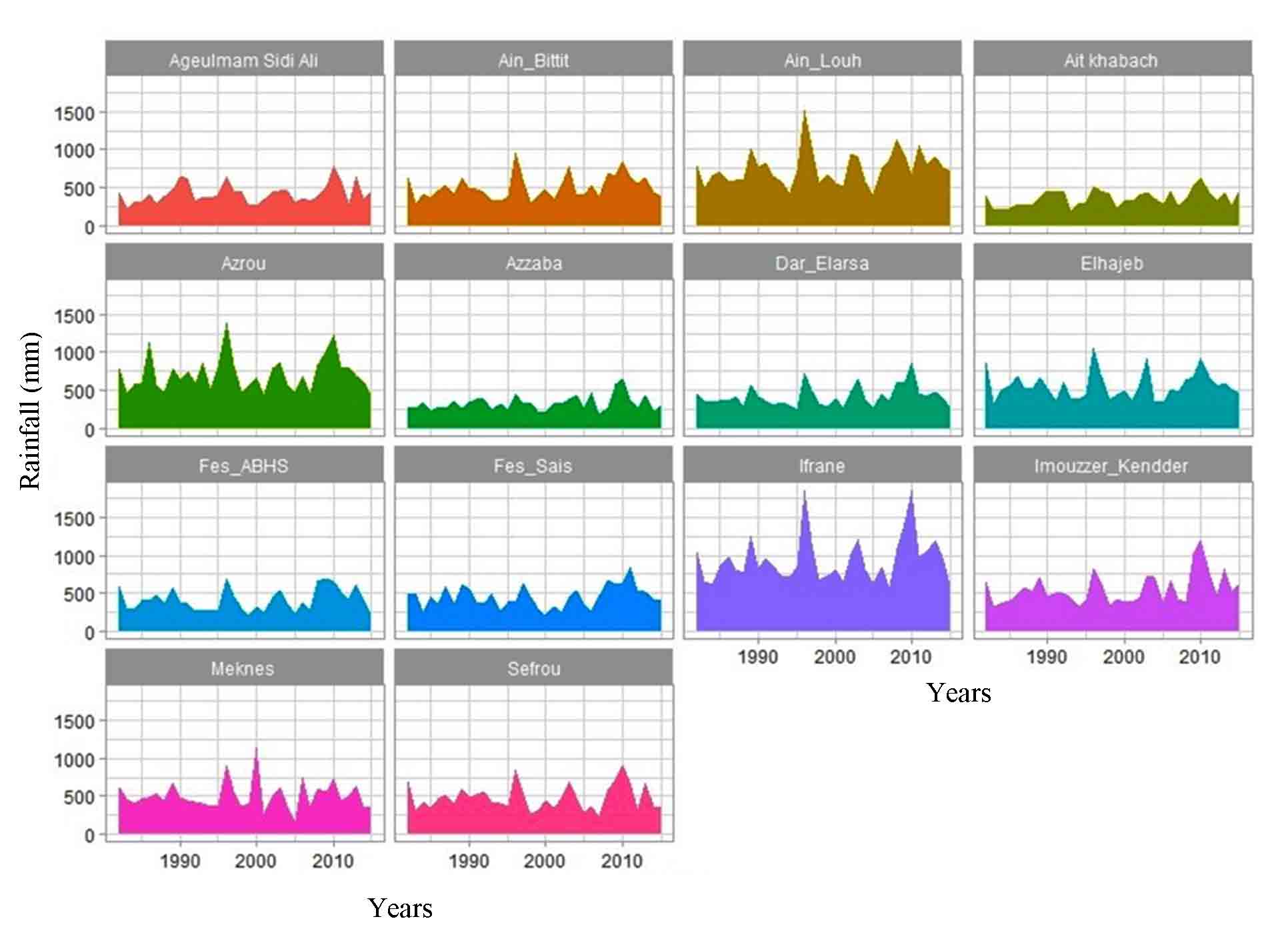
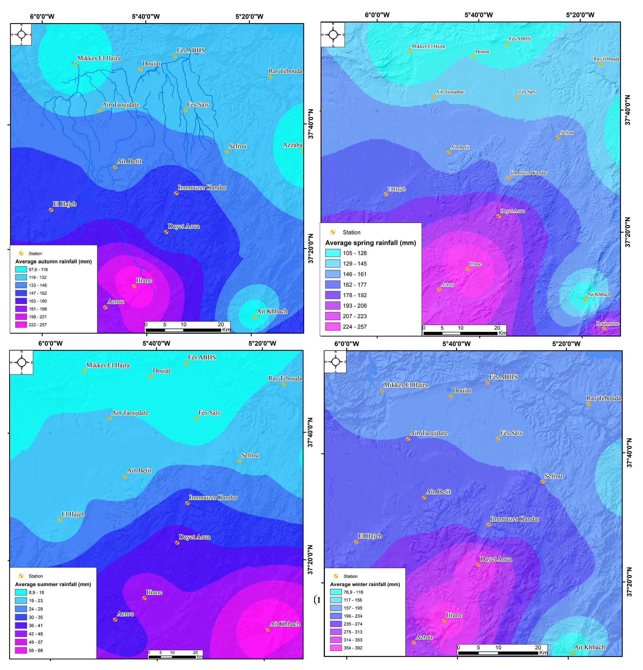
An in-depth statistical analysis was performed for understanding of the spatiotemporal variation of precipitation varies over time and with altitude. The highest areas including the middle Atlastic borders of the Sais plain are quite humid (Figure 2). It receives double the amount of precipitation downstream area (Qadem, 2019; Qadem, 2020). On an inter-annual scale, the amount of precipitation differs from year to year. However, several wet and dry trends have been identified over a century of rainfall observations for the Fez station and the Sefrou station (1915-2015). On an intra-annual scale, precipitation is obviously concentrated in winter and spring. However, the other seasons sometimes receive a large quantity of water, in particular in the Middle Atlas according to a reference period, which begins from 1978 to 2015. This quantity of water recorded either because of summer storms or because of atmospheric disturbances in autumn, that of the Azzaba Station in the Middle Atlas in summer (Figure 3).
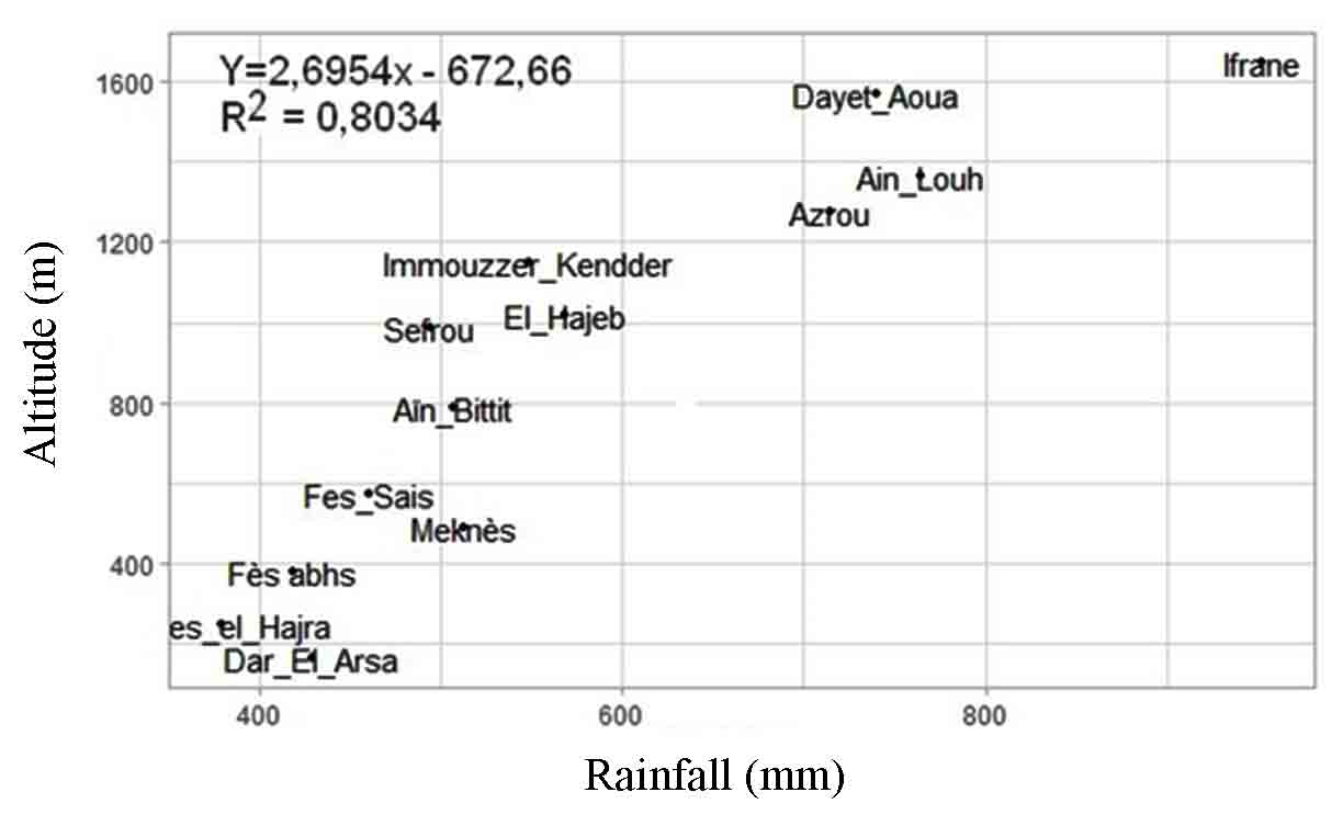
This rainfall variability depends on several factors, of which the topography is the most important by its influence on the rainfall regime. Because it determines the distribution of the rains (Chow et al., 1988) underline that specific conditions the spatial structure of rainfall by the orographic effect due to the rise of humid or dry air masses, adiabatic cooling inducing condensation of humid air on windward slopes. For our study area, the relationship between the average annual rainfall and the altitude of the stations and pluviometric stations (Figure 4) shows that there is a strong correlation between the average annual precipitation and the altitudes. Indeed, the calculation of the correlation coefficient between rain and altitude gives a value of R² = 0.8 which means a very good correlation between the two altitudinal and pluviometric variables.
The study of the hydrological behavior of the springs studied first based on the analysis of the variation in their flow rates, which mainly depends on physical and anthropogenic factors, which intervene directly or indirectly. Secondly, the study of this behavior hinders the quality and length of the series of hydrometric observations used. At the level of the zone in question, only the large springs are periodically calibrated those of the springs of Bittit, Ageumgeum, Ain Chkef, Ribaa, Ain Sultane. Unfortunately, the missing data is much longer than that observed. Faced with this lack of data from these springs, we produced representative and up-to-date data via gauging campaigns from several springs between 2014 and 2018. Before analyzing the hydrological regimes of these springs, the study area was divided into three different parts according to several criteria including the geological and hydrogeological context by contributing the three structural units from South to North. These three parts represent the springs of the Middle Atlas, the springs of the piedmont and the springs of the Saïs plateau.
4.1 Springs of the Middle Atlas Causses: A Hydrological Behavior of the Karst Type
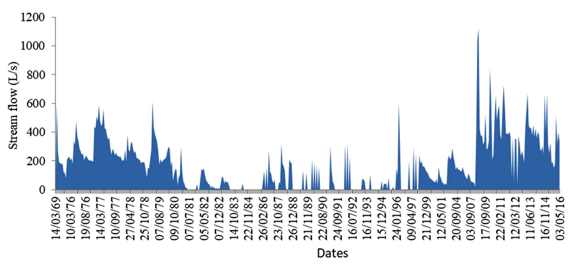
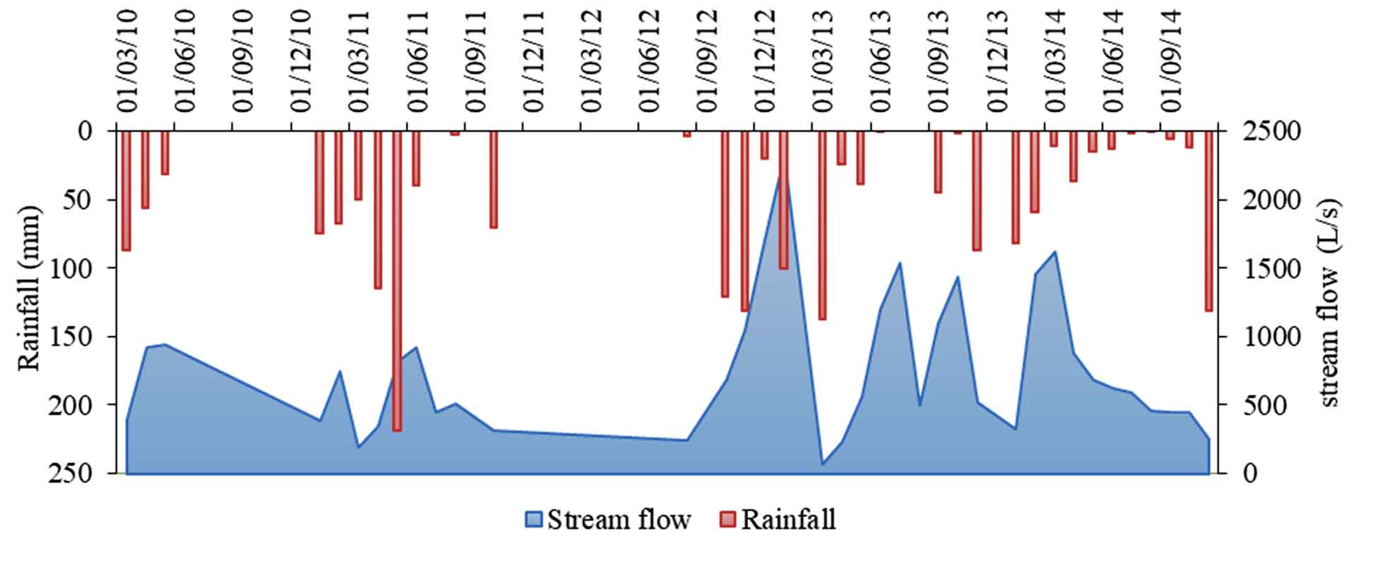
This type of spring characterizes the middle Atlas borders, where carbonate soils favor the infiltration of surface water to provide flow and channeling. The spring of Ain Sultane is located in the Middle Atlas Causse at the level of the Saïs borders. Its flows vary from one year to another the flow data collected from the periodic gauging of the Sebou Hydraulic Basin Agency and then supplemented from the measurements taken between the period of 2014 and 2018. We emphasize that the hydrological regime of the Ain Sultane spring is irregular and strongly conditioned by rainfall trends. However, in wet periods of 2009, 2010 and 2013, its flow rates reached 1000 L/s, while in the early 2000s, flows did not exceed 200 L/s (Figure 5).
4.2 Springs of the Piedmont: A Complex Hydrological Regime
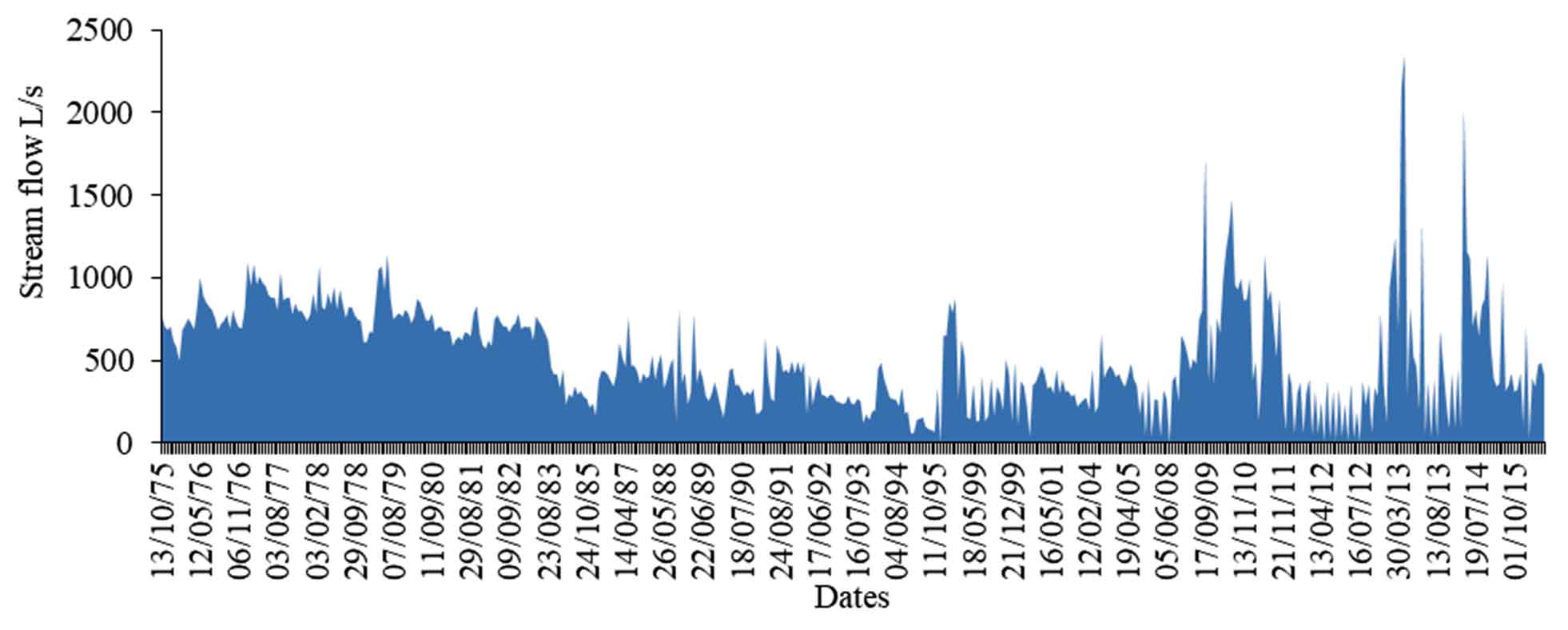
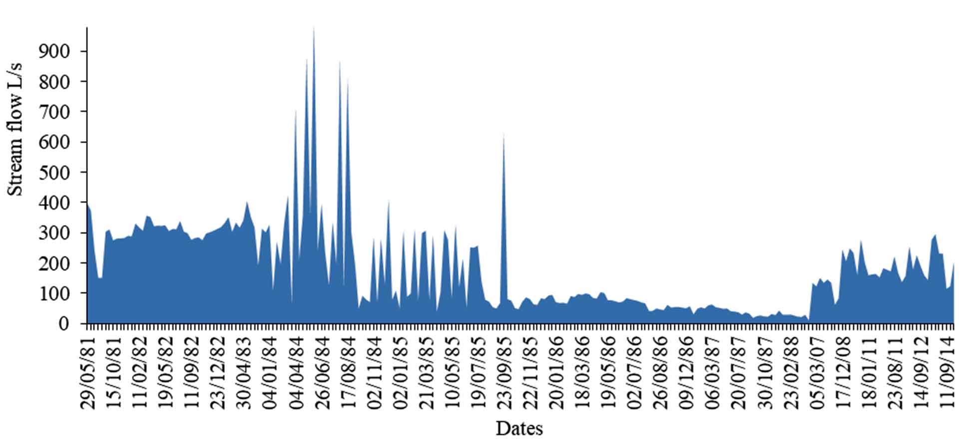
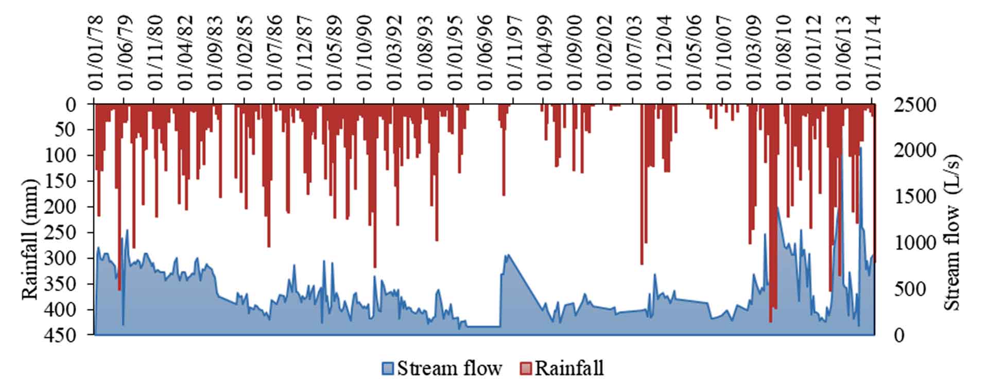
Between the Middle Atlas Causse and the Sais plateau, several springs have characterized this area compared to others including the very permeable nature of the land, which plays a key role in the storage water from the rainfall. Indeed, the cracks in the carbonate massifs favored an underground flow in the form of a well-developed karst. Several springs in the piedmont show one aspect of this hydrogeological system. For example, the springs of the Ribaa-Bittit complex emerge from the Causse Hajeb-Ifrane aquifer. These artesian spring (that of Akkous) and overflows (Ribaa Amont, Ribaa Aval, Bittit, Atrous and Sebaa) are characterized by a large and significant flow. The hydrological regime is quite irregular. The variation in the flows of the springs of Ribaa upstream and Ribaa downstream shows that there are three very distinct trends (Figure 6 and Figure 7).
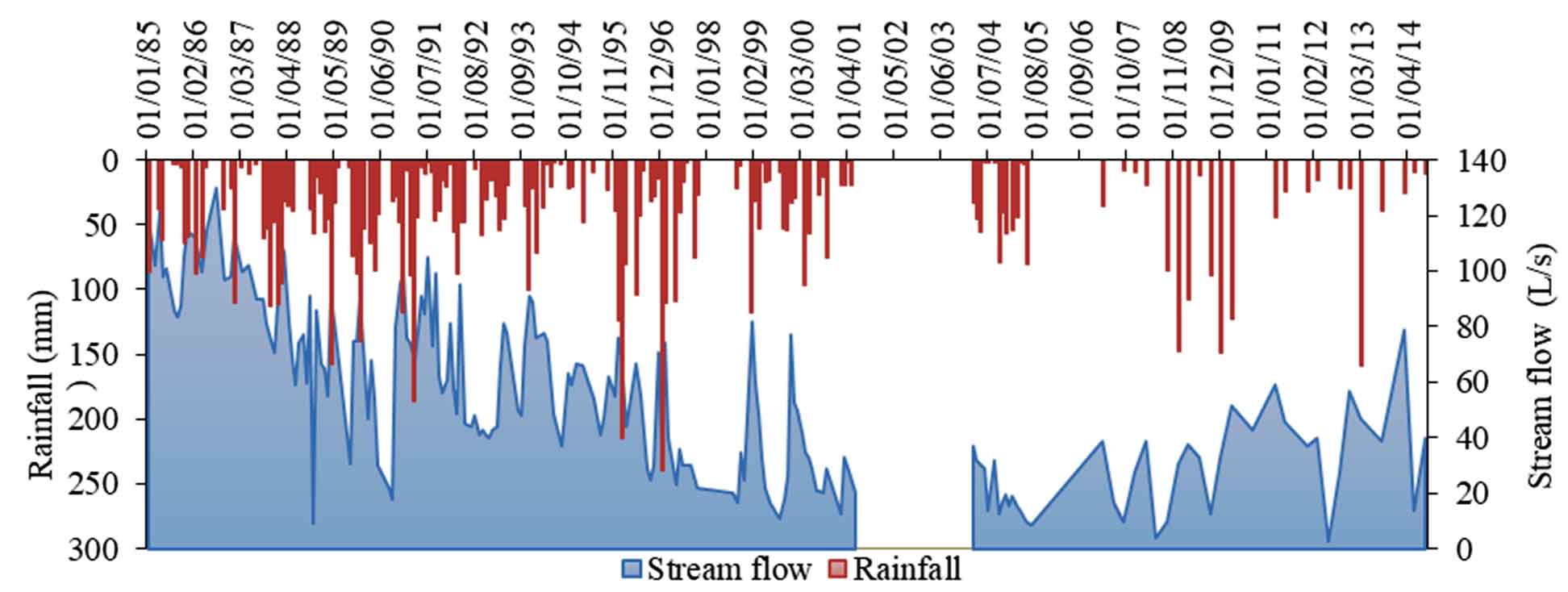
Before 1980, the two springs were characterized by high water productivity. The flow rate of the Ribaa Upstream spring has never fallen below 500 L/s. In 1980 and 1995, the flow of Ribaa upstream and downstream, decreased sharply during this period. Morocco has experienced an acute drought affecting aquifers as well as the flow of springs, which have experienced a drying up or even total drying up. Despite this dry period, the upstream Ribaa spring never dried up, but its flow rate decreased remarkably, it reached 69 L/s in March 1995, i.e. a decrease of approximately 1000 L/s compared to October 1976. The maximum flow for this period was recorded in October 1988, with a productivity of 805 L/s. The maximum flow for this period was recorded in October 1988 with a productivity of 805 L/s.
The Ribaa downstream spring, for its part, experienced total drying up for several years (1982, 1985 and 1991). The maximum flow during this period was in the order of 322 L/s in May 1992. Between 1996 and 2016, the year 1996 was marked by the return of the rains and consequently an increase in the flow rates of the springs studied. After this exceptional year, drought reigned over Morocco once again, until 2009, when there was a new very wet trend. The absolute record for the flow of upstream Ribaa was recorded in April 2013, with 2349 L/s and 1117 L/s at Ribaa downstream in March 2009.
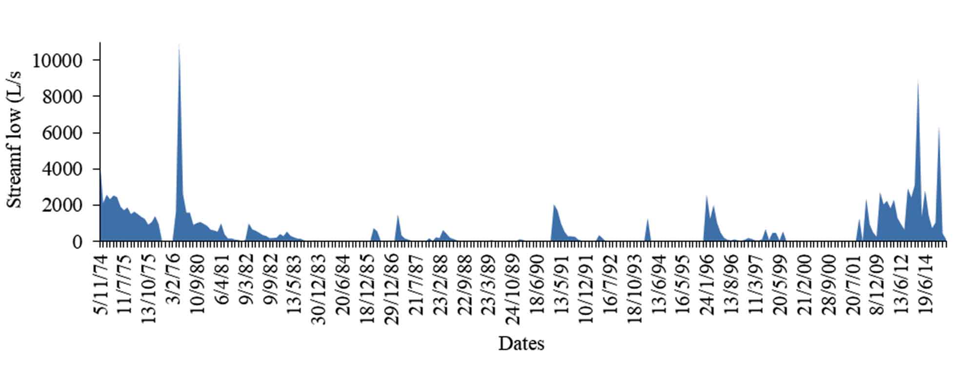
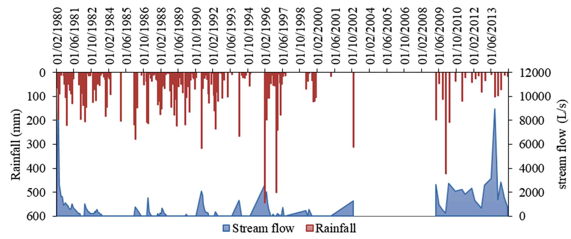
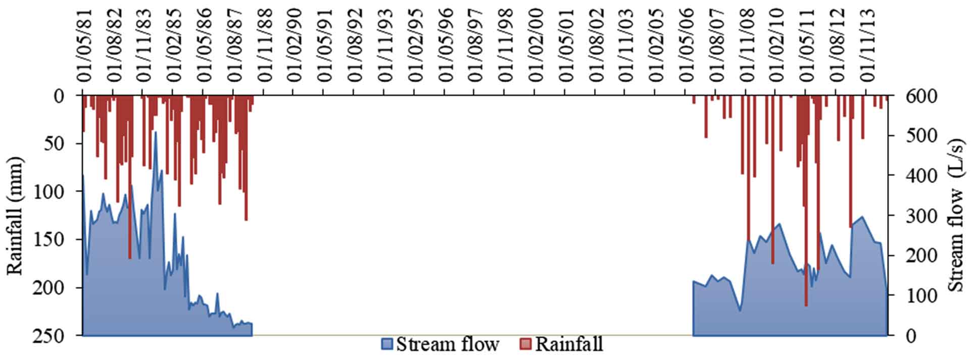
For complex springs, Bittit (Figure 9) and Aguemguem springs (Figure 8) are characterized by a very different hydrological regime, although the distance between them does not exceed 5Km. In fact, the hydrological regime of the Aguemguem spring is very irregular on an annual and seasonal scale. Year after year, the flow from this spring can exceed 2000 L/s in wet periods (1996, 2009, 2010, 2013 and 2015) and completely dries up in drought periods. For the Bittit spring, it is characterized by a fairly stable hydrological regime. Its flow rate generally remains between 500 and 700 L/s. However, in May 1981, this spring experienced a total drying out. This event affected all the springs in Piedmont.
4.3 Springs of the Saïs Plateau From Abundance to Destitution
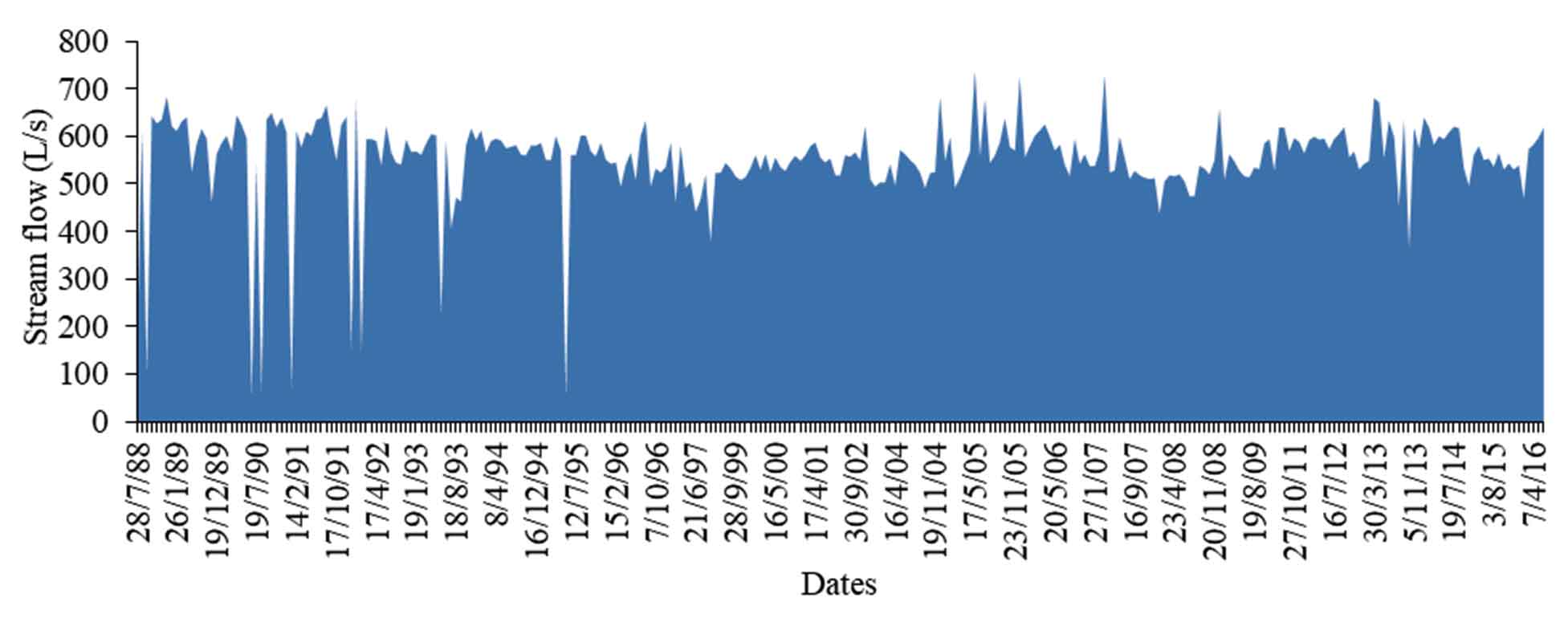
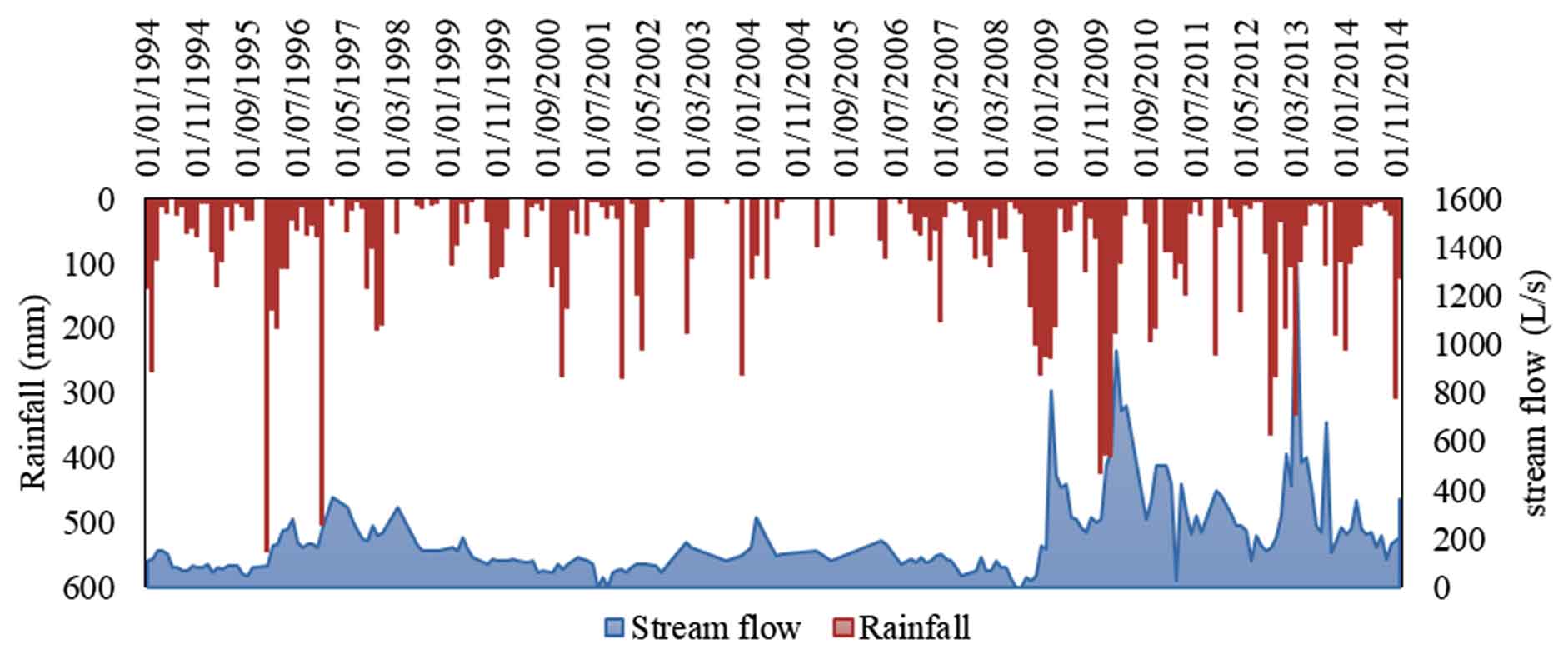
Like the Middle Atlas and its foothills, the Saïs plateau is characterized by several springs springing from the Plio-Quaternary water table and the deep Lias water table. Indeed, they are emergence and discharge springs with quite different flow rates. These flows declined dramatically and remarkably during the 1980s, and unfortunately, many of them dried up completely in the early 2000s. Despite the return of the rains, these springs were unable to regenerate due to pumping which accentuated the extent of the water deficit during the dry years. Among the most important springs that have dried up are the Ain Cheggag spring, which flowed 115 L/s in April 1988, and the Boukhnafer spring, which flowed over 50 L/s in 1988. The drying up phenomena of these springs is linked, on the one hand, to the reduction in the flow rates of the Oued crossing the Saïs plateau, and on the other hand, to the harmful effects of accelerated pumping intended to supply urban centers and rural people with drinking water, as well as irrigation water. Regarding large springs, Ain Chkef presents a good example (Figure 10). Part of its flow intended to supply the agglomeration of Fez with drinking water.
Regarding large springs, Ain Chkef presents a good example intended to supply the agglomeration of Fez with drinking water. This spring characterized by stable flow.
The period preceding 1984 was characterized by significant water inputs. The flow has remained more or less stable throughout this period until 1984 when the flow reached 991 L/s in the month of May. After this exceptional year, a new dry trend is needed. After 1985, the average flow of the Ain Chkef spring fell from 250 L/s (1981-1984) to only 57 L/s (1985-2007). During this period, the flow of the Aïn Chkef spring remained very stable at around 50 L/s. The minimum flow was recorded in September 1988, with only 11 L/s. the third period (2007-2015) corresponds to wet years, characterized by an increase in the average flow of this spring up to 193 L/s. The maximum flow was recorded in December 2015, with 639 L/s.
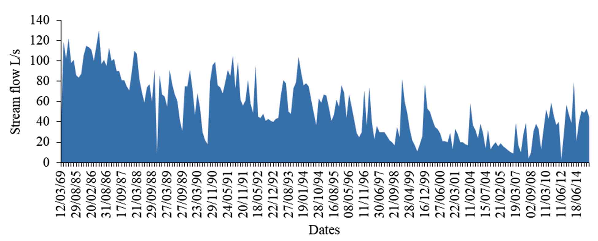
For the spring of Amellal which is located at the level of the Western part of the plain of Sais Fez (Figure 11). This is one of the mixed springs (overflow and emergence). The flows from this spring experienced a constant regression, until the flow in the 2010s. During the late 1960s, flows from this spring generally exceeded 100 L/s. But, during the 1980s, the average of its flow fell to 86 L/s, then 54 L/s as the average of the 1990s, then 25 L/s during the 2000s and finally, this average rose to 45 L/s during the middle of the second decade (2010-2015). More recently, the last measurement taken on this spring (February, 2018) gave 92 L/s as instantaneous flow.
Generally, the springs of the Middle Atlas, the Dir and the Saïs plateau are marked by very different hydrological behaviors. This variation and sensitivity are clearly visible on the annual scale but what about the seasonal scale. To answer this question, we based ourselves on the periodic measurements of the upstream Ribaa and Bittit springs. The choice of these two springs is justified by their homogeneous observation records with little missing data (Table 1). From the data obtained, we can say that the Bittit and Ribaa upstream springs have a regular regime (Table 1 and Figure 12).
Table 1. Seasonal variations in flow rates
|
Springs
|
Years
|
Winter
|
Spring
|
Summer
|
Autumn
|
|
Ribaa
|
1988
|
737,33
|
830,00
|
761,33
|
720,00
|
|
1994
|
324,50
|
401,67
|
267,67
|
246,67
|
|
2000
|
323,00
|
344,00
|
208,00
|
368,00
|
|
2010
|
1075,50
|
1238,00
|
930,00
|
929,50
|
|
2015
|
260,60
|
*
|
498,25
|
352,00
|
|
Bittit
|
1988
|
621,00
|
*
|
371,25
|
648,33
|
|
1994
|
584,25
|
592,00
|
578,00
|
560,50
|
|
2000
|
545,00
|
547,33
|
536,00
|
553,50
|
|
2015
|
530,00
|
565,00
|
546,33
|
546,00
|
|
2017
|
*
|
743,00
|
*
|
*
|
* Missing data
Spring (high water) is the only season, when the flow is visibly quite important compared to the other seasons, which have almost the same seasonal modulus. This hydrological regime is not common to all the springs studied. From the fieldwork carried out, a large difference in flow rates between high and low water was observed. Indeed, according to Amraoui (2005), the Aguemguem, Attrous and Si Lmir springs from 1984 onwards became temporary emergencies, appearing during heavy downpours, with seasonal fluctuations much more marked than before.
The springs in the plateau of Sais and its borders are very numerous and are characterized by significant water inputs. The hydrological behavior of these springs is very variable and depends essentially on the hydrogeological context, which contributes to their supply. However, the factor determining the performance of these springs is summarized in the rainfall inputs.
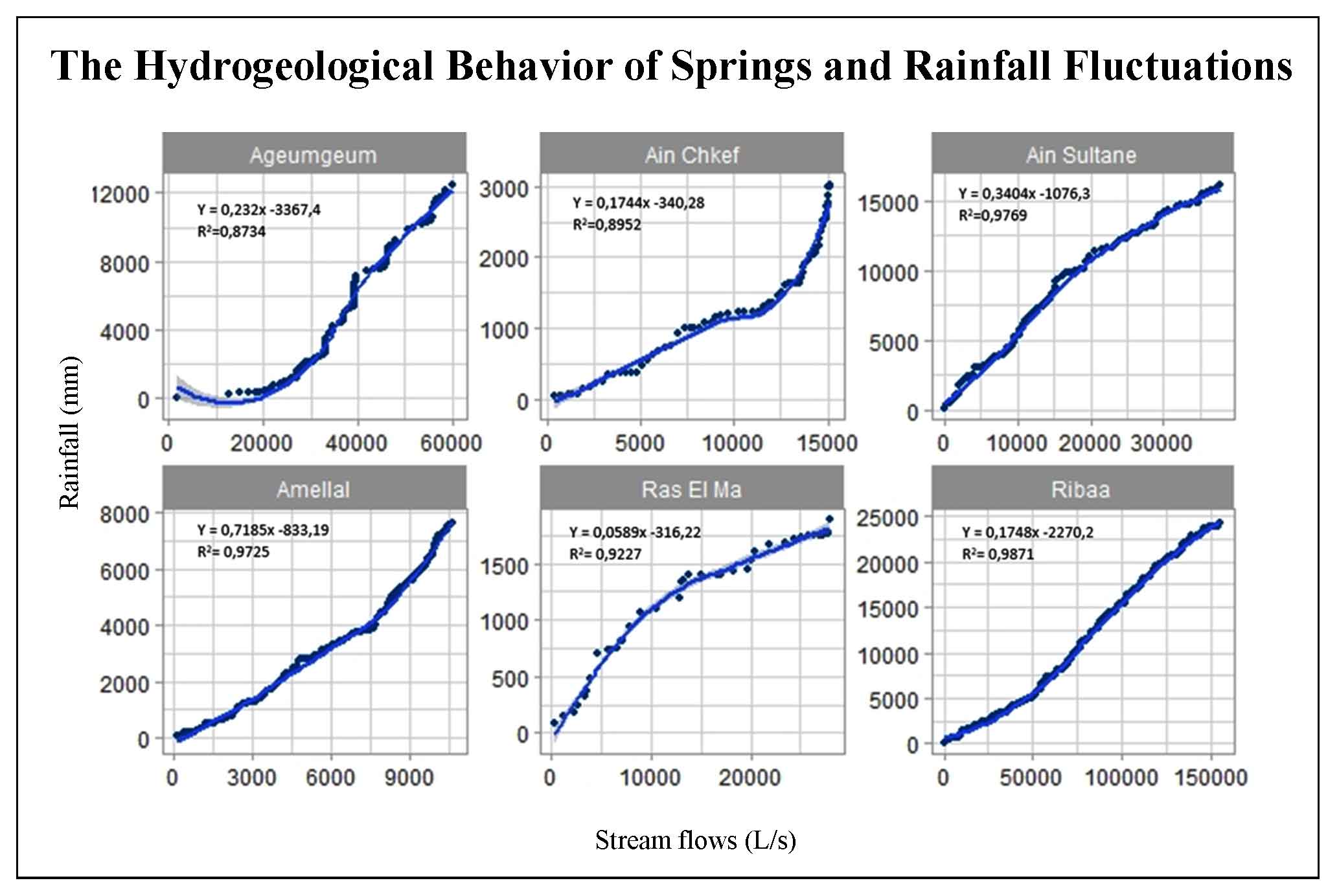
4.4 Rainfall-Discharge Relationship of the Springs of the Two Watersheds Studied
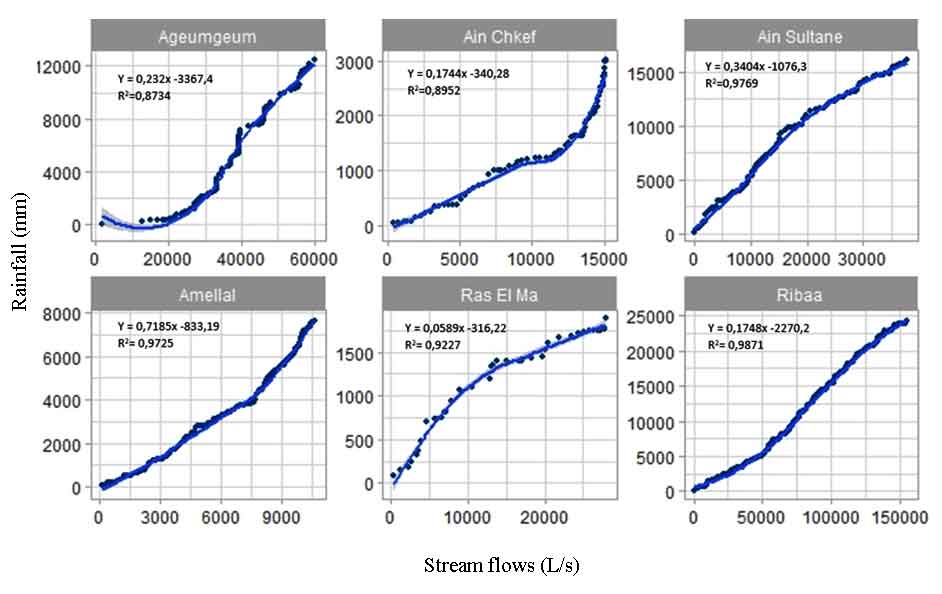
To fully understand the relationship between precipitation and the flow of springs located in the plain of Sais and its borders, this analysis is based on the monthly average precipitation of the Ifrane, Fez-Saïs and Meknès stations located near the Ribaa, Aguemguem springs, Ain Chkef, Ain Sultane, Ras El Ma and Amellal (Figure 13). The method adopted aims to understand the relationship between the rainfall contributions and the flow rates of the springs in the area in question, based on the coefficients of determination (Figure 13 and Table 2).
Table 2. Relation between rainfall and stream flows
|
Springs
|
Periods
|
Stations
|
R2
|
|
Ribaa
|
Jan. 1978 / Dec. 2014
|
Ifrane
|
0.98
|
|
Ageumgeum
|
Feb 1980 / Sep 2014
|
Ifrane
|
0.73
|
|
Ain Sultane
|
Jan. 1994 / Dec. 2014
|
Ifrane
|
0.97
|
|
Ain Chkef
|
May 81 / May 1988
|
Fez Sais
|
0.89
|
|
Ras El Ma
|
March 2010 / Nov. 2014
|
Fez Sais
|
0.92
|
|
Amellal
|
Jan 1985 / Sep 2014
|
Meknès
|
0.97
|
With the exception of the spring of Ain Chkef (R² = 0.89) and Aguemguem (R² = 0.87), the flows of the springs studied have a very strong correlation with the rainfall amounts (R² > 0.97). The rainfall-runoff relationships and trends well illustrated for these springs studied. We can clearly see that following each heavy rainfall episode, the flow of the springs increases remarkably, always with the exception of the Aguemguem and Ain Chkef springs. This is explained by the special mode of recharging and emptying the aquifers, which are at the origin of these two springs. Without forgetting the anthropogenic factor which deeply influences the hydrological functioning of the springs in question. In fact, the pumping and abstraction of Wadis water controls this relationship between rainfall and springs flow rates.


 ,
Abdelghani QADEM 1
,
Abdelghani QADEM 1