1.Department of Geography, Tuljaram Chaturchand College of Arts, Science and Commerce College, Vivekanand Nagar, Baramati- 413102,
Maharashtra (India).
The multi-proxy data of the tank sediments can provide the nature of monsoon of variability in the catchment of historical tanks.
Tank sediment samples were analyzed from 4-5 m thick sections to understand hydrodynamic condition.
The upper (and younger) sediments show considerable variations in the sediment characteristics.
The minor variations in the grain size in the tank deposits only represent such high-magnitude random event.
The study shows only short-term, subtle to modest changes in the hydrodynamic conditions in the catchment area.
Abstract
Global climate change is the predominant socio-economic, environmental and political issue confronting the mankind in the 21st century. The humanity in future is likely to depend upon the realistic assessment of the present climate and reasonably accurate prediction of the future climate change. This requires better understanding of the dominant characteristics of past climates. Lakes andtanks located in the semi-arid and arid regions are particularly suitable for palaeoclimatic studies, because of their high sensitivity to shifts in precipitation. The present study has been carried out using multi-proxies (e.g., textural, geochemical, mineral magnetic and charophytes studies) of sediments of two historical tanks namely, Bhatodi (~450 yrs old) and Mastani (~270 yrs old), from the rain-shadow zone of Western Maharashtra to understand the nature of monsoon variability in the catchment area of the tanks. The multi-proxy analyses of 4-5m thick sediment sections have revealed that with the exception of some minor sedimentary units in the middle, the lake sediments are by and large similar. This implies only short-term, subtle to modest changes in the rainfall and runoff conditions in the catchment area during the last 2-3cm. There is no evidence a major shift in monsoon rainfall conditions in the rain-shadow zone.
Keywords
Monsoon Variability , Multi-proxy studies , Rain-Shadow Zone , Short-term events , Tank sediments
1 . INTRODUCTION
In the context of India, monsoon plays very significant role in the agricultural production of the country. The water availability and production of the crops is significantly dependent on the spatial and temporal distribution of the monsoon (Singhvi and Kale, 2009). Climate change, associated with human-induced global warming, has been described as the greatest challenge facing the world today (IPCC, 2013). The future of humanity is likely to depend upon the realistic assessment of the present climate and reasonably accurate prediction of the future climatic changes at different time-scales. This requires better understanding of the dominant characteristics of the present and past climates. Reconstruction of the past climatic characteristics at the local, regional and global levels is necessary to understand the present climate variability and to predict the reliable scenarios of climatic change(s) occurring in the future.
In comparison, the Deccan Basalt Province (DBP) of Maharashtra in general and the rain-shadow zone of the Western Ghats in particular, do not have major archives and natural lakes which can provide high resolution and continuous record of past monsoon variability. Although the Lonar Lake in the Buldhana District of Maharashtra is a natural lake, it does not fall in the climate-sensitive rain-shadow region. There are some fluvial deposits but these are highly patchy and discontinuous (Kale and Rajaguru, 1987). In the absence of major archives and natural lakes in the area under study, some historical tanks were investigated. More than a dozen historical tanks occur in the western Deccan Basalt Province (DBP) and these range in age from the 16th to 19th century and were constructed by local rulers or the British government as water retention measures in drought-prone areas for drinking and irrigation purposes.
Therefore, the major objective of the present study is to reconstruct the nature of monsoon variability in the rain-shadow zone of the Western Ghats by undertaking a multi-proxy investigations of the sedimentary records preserved in two man-made historical tanks in the western Deccan Basalt Province (DBP).
2 . THE RAIN-SHADOW ZONE
Monsoon is the defining characteristic of climate in the area under review. On the leeward side of the Western Ghats, the annual rainfall rapidly decreases (500-650 mm) and the coefficient of variability increases (30%). High runoff in small catchments is a direct response to short-duration heavy rainfall spells (>100 mm/day) during the monsoon season (June to September). The present study is based on the premise that long-term changes in the frequency and magnitude of such heavy rainfall events could be reconstructed from the sedimentary records of small-catchment, historical tanks located in the climatically sensitive, rain-shadow zone of the Western Ghats in the DBP.
One of the basic assumptions in the lake-based climate reconstruction is that the lakes accumulate sediments continually since their formation and the sediment sequence is an uninterrupted environmental archive, which contains information about the history of the lake and its surroundings. However, in semi-arid and arid regions, desiccation of lakes isn’t uncommon. Severe droughts or long dry spells are a characteristic feature of the rain-shadow zone of Western Ghats. This has important implications on the completeness of the monsoon variability records in the historical tanks under review. High sensitivity of the small lakes and tanks makes them prone to dry out completely or in some years not receiving any flow from the catchment, resulting in truncation or breaks in the sedimentary archive that has been accumulating in the historical tanks.
3 . HISTORICAL TANKS UNDER STUDY
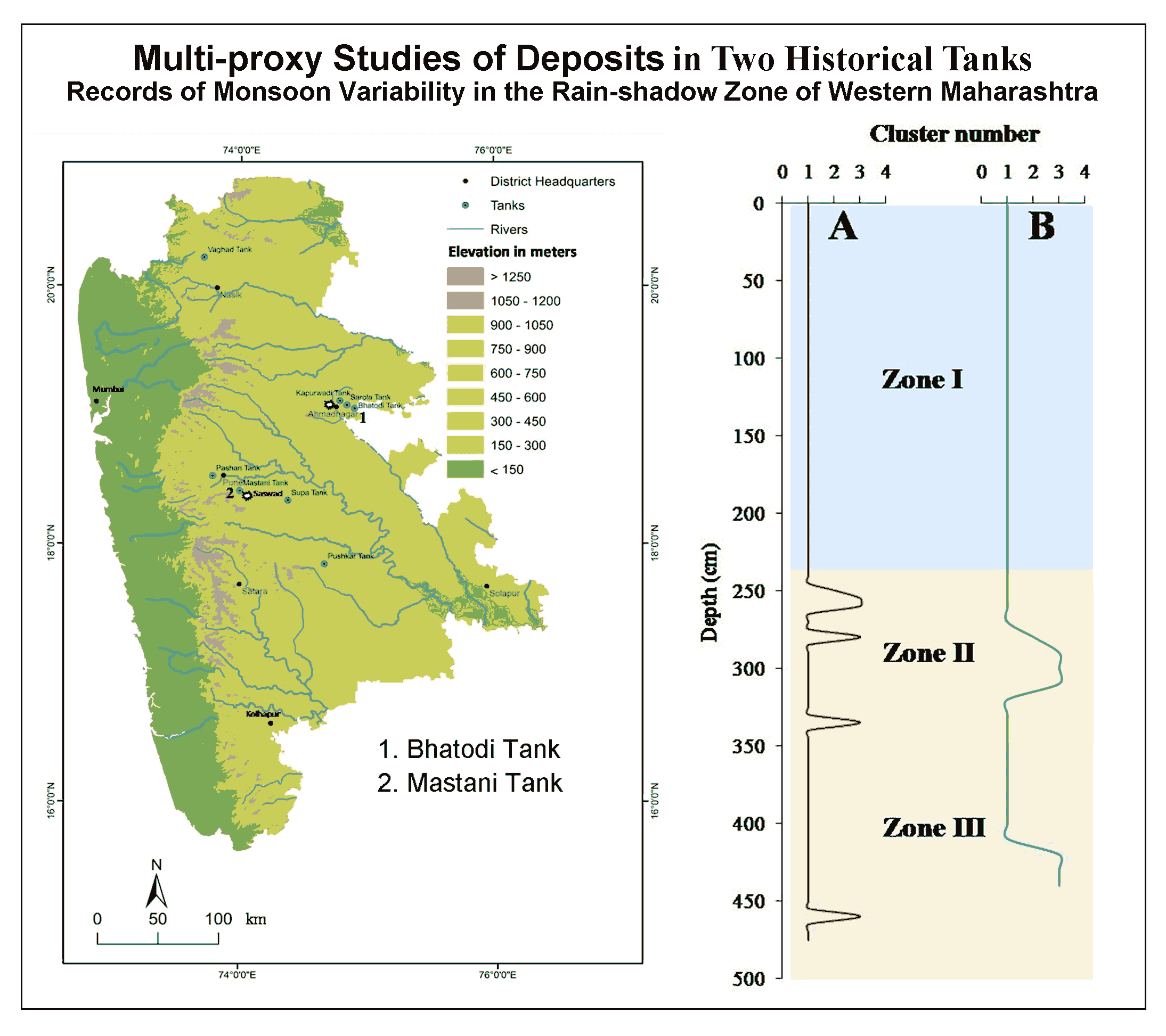
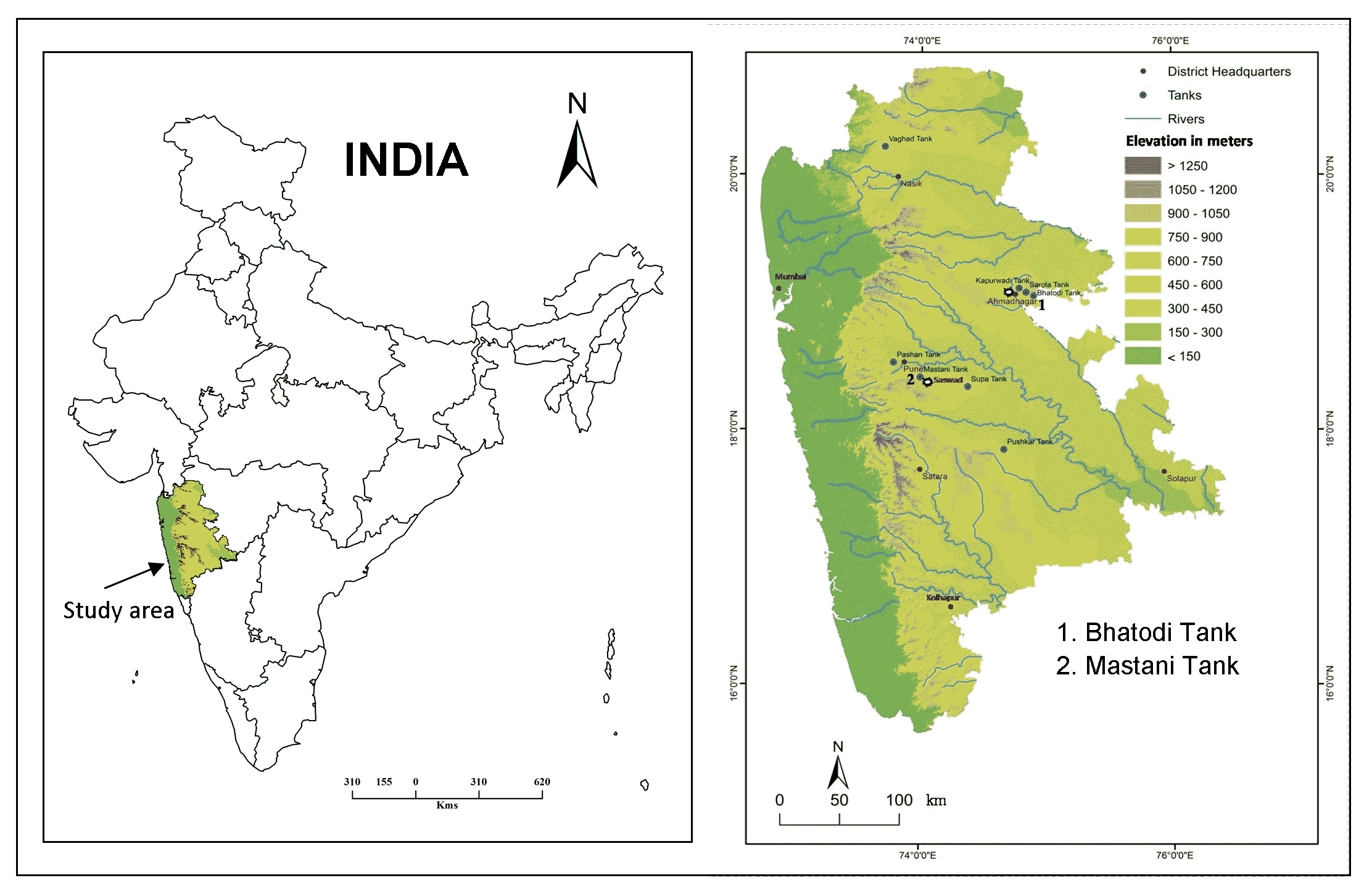
The two historical tanks under review, namely Bhatodi and Mastani are located in the semi-arid region of the Deccan Basalt Province (Figure 1). The annual rainfall in the area varies between ~550 and 650mm. Short ephemeral streams drain into the tanks are the main sources of water and sediments. Generally, the tanks contain water for a longer duration during good monsoon years and after wet spells. The tanks are almost dry during poor monsoon years, such as in 2002 (Mastani Tank) and 2003 (Bhatodi Tank). However, short heavy rainfall spells even during poor monsoon years can bring lot of water and sediments into the tanks. Therefore, the sedimentary records of the tanks provide information about the short heavy rainfall spells.
The Bhatodi Tank (19o 4¢N and 74o 54¢E) is located about 20km southeast of Ahmednagar city in Maharashtra (Figure 1). The upstream area of the tank is about 119km2. The tank is surrounded by low hills from three sides. The altitude of the area varies between 720 and 959m ASL [Average Sea Level]. This tank was built by Salbat Khan, minister of the fourth Nizam Shah, in the year 1565 AD (Gazetteer of Ahmednagar District, 1976). The tank, therefore, has recorded the history of the tank and its surroundings during the last four and half centuries. Recently, another weir has been constructed upstream of the Bhatodi Tank. As a result, the water and sediment inputs have decreased substantially and the modern records are not very reliable.
Figure 1. Study area: Western Maharashtra (India)
The second tank, popularly known as the Mastani Tank (18o 25¢N and 74o 0¢E) is located about 25km southeast of the Pune city (Figure 1). The catchment area of the tank is about 0.17 km2 and the area of the tank is ~18.2 103m3. The tank is surrounded by high and steep hills. The altitude varies between 700 and 950m ASL. Historical records indicate that the early 18th century Maratha General, Bajirao Peshwa, built the tank around 1740AD (Gunaji, 2010). It is reasonable to infer that the information about hydrological changes and sediment dynamics during the last ~270 yrs. is preserved in the tank.
4 . MATERIAL AND METHODS
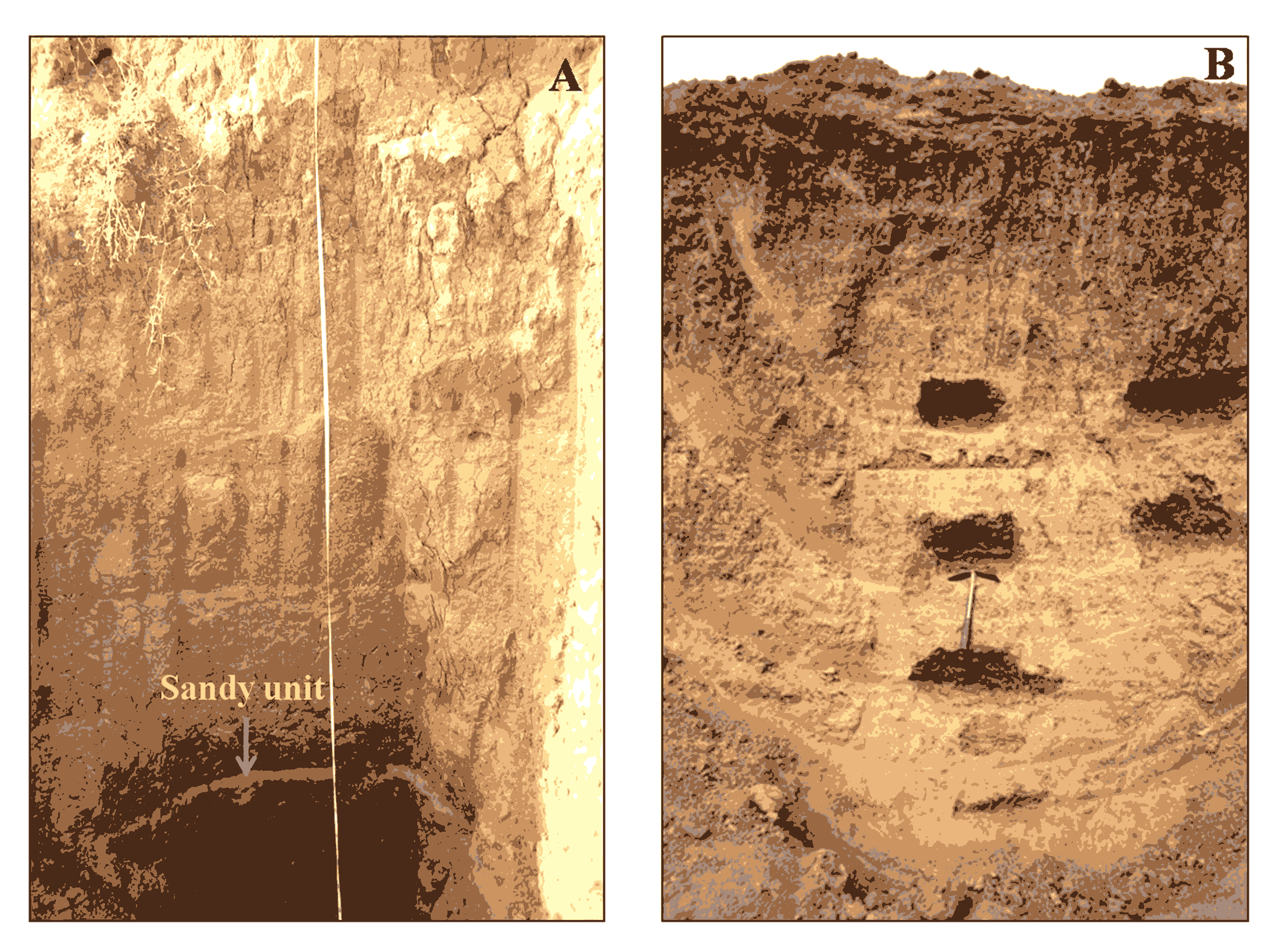
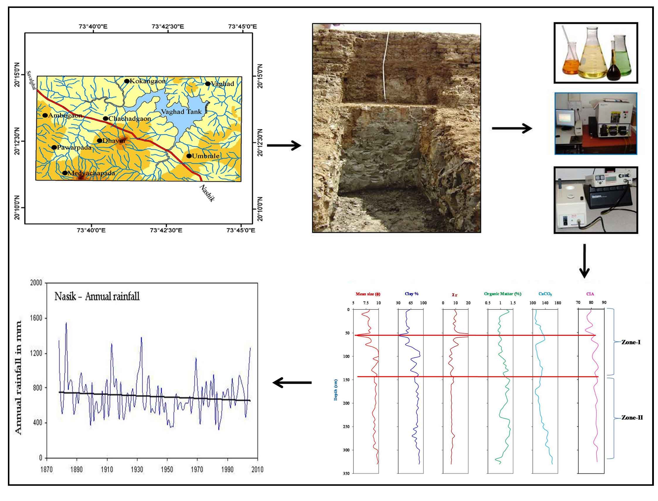
In order to determine the changes in the sediment properties through time, step-trenches or pits were taken in each historical tank under review. The sediment sections were exposed to understand the stratigraphic characteristics of the sediments (Figure 2). The sediment thickness in both the tanks varies from 4 to 5m spanning ~270 to 450yr. The deposits lack near-annual resolution, due to frequent breaks in sedimentation during weak or dry monsoon years. Very close sampling is not likely to give a high-resolution (annual) record of monsoon variability. Although there is no systematic data, general observations indicate that the sediment flux is remarkably high during the infrequent, extreme events. The sediment samples were collected at an interval of 5-10cm for geochemical, mineral magnetic and textural analyses as well as Chara count studies. Nearly 140 samples were collected from the two historical tanks.
Figure 2. The sections of the Bhatodi Tank (A) and Mastani Tank (B) exposed in the step trenches.
Grain size measurements were carried out using a Sedigraph Particles Size Analyzer. The grain-size data were used to obtain the textural classes of the sediments. Using the data, graphic measures, such as, mean size, sorting, Skewness and Kurtosis were estimated.
Dual frequency (0.47 kHz and 4.7 kHz) magnetic susceptibility meter (Bartington MS2) was used to measure the magnetic parameters such as low-frequency magnetic susceptibility ( \(χ_{If}\) ) and its frequency dependent component ( \(χ_{fd}\) %) to get information about the grain-size distribution and amount of magnetic minerals following Basavaiah and Khadkikar (2004) and Foster et al. (2008).
Elemental composition was obtained by the X-ray Fluorescence Analysis. The Chemical Index of Alteration (CIA) was calculated using the corrected elemental data to evaluate the degree of weathering of the tank sediment. It is based on the following equation proposed by Nesbitt and Young (1982).
\(CIA = 100 × Al2O3/(Al2O3 + CaO + Na2O + K2O)\)
In many recent studies, charophytes have been used as lacustrine biomarkers. Charophytes are green rooted algae that reflect the environmental conditions in general and lake level stands and rainfall pattern in particular. The presence of charophytes indicates submergence for at least three months (Sulien-Marsche, 1991). Therefore, in order to further complement the textural, geochemical and magnetic susceptibility analyses, Chara studies were undertaken. The present study is entirely based on these four primary analyses.
5 . RESULTS
5.1 Sediment Texture
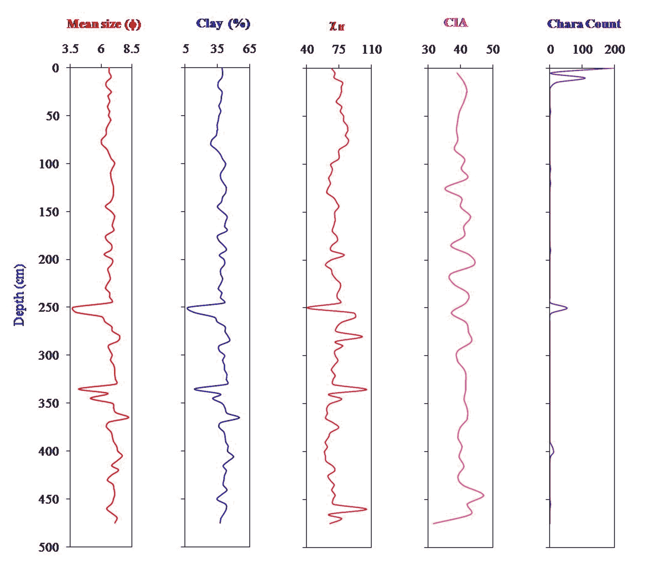
The hydrodynamic processes and energy conditions determines the variations in the grain-size classes. Production or transport of coarse grains is generally corresponds to higher energy conditions and vice versa (Alin and Cohen, 2003). Particle size analysis of the Bhatodi Tank sediments reveals dominance of clay (44.2-66.1%). Sand constitutes a very low proportion in the samples (<1.6%). Silt also has a substantial proportion in some samples (33.3 to 54.8%). Plotting of the textural data on soil textural triangle reveals that the sediments belong to the clayey and silty textural class. The percent of sand shows an increase at 250, 255 and 335cm depth (Figure 3).
Figure 3. Vertical variation in the mean grain size, percentage of clay, low-frequency magnetic susceptibility, Chemical Index of Alteration and Charas for the Bhatodi Tank deposits
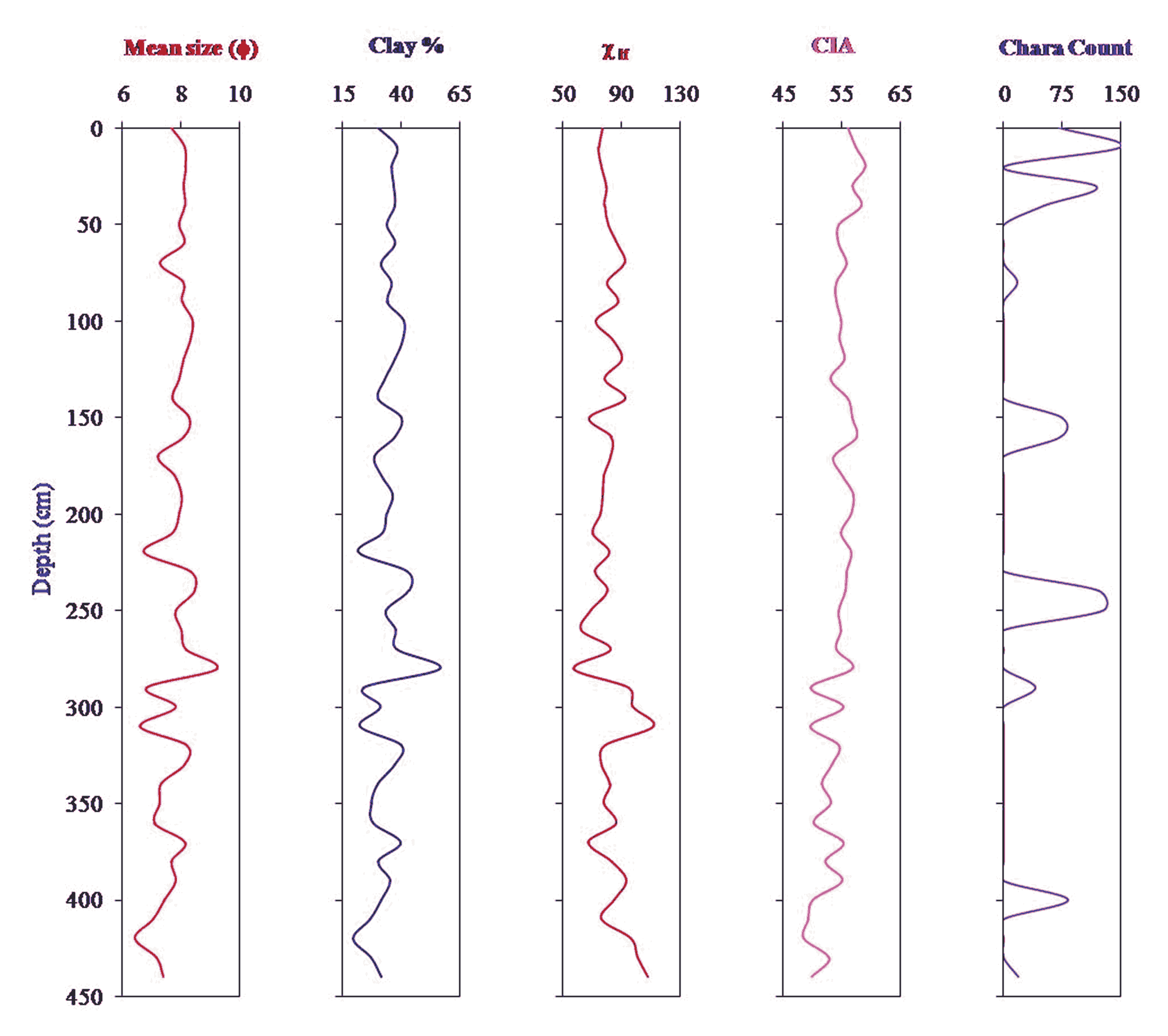
In comparison, the Mastani Tank sediments are dominated by silt, which varies from 41.2 to 64.9%. The percentage of sand ranges between 1.8 and 36.3%, whereas clay constitutes 19.2 to 56.5% in the samples. Plotting of the textural data on soil triangle reveals that the sediments belong to the silty-clay or silty-clay loam textural class. The percent of sand shows a notable increase at 290 and 310cm depth (Figure 4).
Figure 4. Vertical variation in the mean grain size, percentage of clay, low-frequency magnetic susceptibility, Chemical Index of Alteration and chara count for the Mastani Tank deposits
5.2 Magnetic Susceptibility
The measurement of magnetic susceptibility of Bhatodi Tank sediments ranges from 40.7 to 104.7 \( \times\) 10-7m3kg-1. The average low frequency magnetic susceptibility value is 71.5 \( \times\) 10-7m3kg-1. The percentage frequency dependent susceptibility of the samples varies between 0.52 and 1.95% with an average of 1.44%. The plot given in figure 3 reveals a general increase in the magnetic susceptibility towards the top ~100cm indicating predominantly allochthnous unweathetred sediment. Peaks in magnetic susceptibility reflect the layers of unweathered material deposited during the extreme high rainfall conditions in the catchment area of the tank.
Figure 4 gives the magnetic susceptibility of Mastani Tank. It is apparent that the percentage frequency dependent susceptibility of the samples varies between 0.81 and 2.47% and the magnetic susceptibility ranges from 57.34 to 111.5 X 10⁻⁷m3 kg-1. Trend analysis reveals that the magnetic susceptibility values decrease toward the top but the values of percentage frequency dependent susceptibility increase. The high \(χ_{fd}\) % values indicate soil derived sediment input and thus the sediments in the top are characteristic of fine-grained, weathered soil. This may indirectly suggest the lowest sedimentation rate or uniform rainfall variability or absence of the heaviest rains occur during localized storms, flash floods or their remnants.
5.3 Chemical Index of Alteration (CIA)
Chemical Index of Alteration values generally range between <50 and 100 (Price and Velbel, 2003). Ions of Ca, Na and K are very mobile. Therefore, low CIA values indicate very little chemical changes in the rocks. Conversely, high CIA values reflect high degree of weathering (Nesbitt and Young, 1982). The CIA values of the Bhatodi Tank samples range between 31.5 and 47.0 indicating dominance of unweathered material. There is also no noteworthy trend in the vertical variation in CIA (Figure 3) implying no change in the degree of weathering with time (depth).
Slightly higher degree of weathering is reflected by the CIA values for Mastani Tank sediments (48.4 to 58.9). By and large, there is a subtle increase in the CIA values towards the top (Figure 4). This is to say, that the sediments close to the top (and thus younger) are relatively more weathered than the lower or older sediments conforming the trends seen by \(χ_{fd}\) % values.
5.4 Charophytes Studies
The top 20cm sediments at Bhatodi have yielded excellently preserved charophytes. These are calcified fructifying bodies and their occurrence indicates the presence of water in the tank for at least three months. Down the profile, there is striking absence or low counts of Chara. Only at 250cm depth there is an indication of sudden increase in the pulse of water. This is reflected by moderate counts of Chara. Incidentally, the Chara associated sediments occurring at this depth have also shown a remarkable increase in the sand percentage (Figure 3).
The picture is quite different at Mastani. Here also the top 40cm clay to silty-clay samples have yielded excellently preserved charophytes. But, unlike Bhatodi Tanks, sub-recent algae in appreciable quantities occur at 80, 150, 160, 240, 250, 290, 400 and 440cm depths (Figure 4). This only goes to show that the tank was filled with water for longer duration several times during the last two and half centuries.
5.5 Cluster Analysis
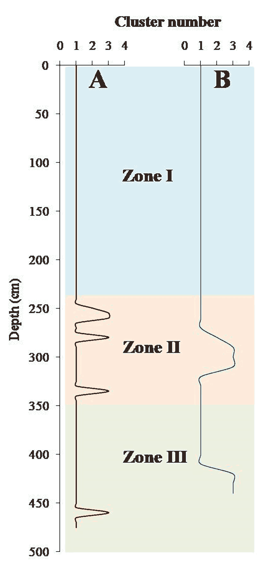
It is evident from figure 3 and 4 that the tank records feature subtle to high variability in grain size, magnetic susceptibility, CIA and Chara content. There is little convincing visual correlation between mean size, percentage of clay, magnetic susceptibility, CIA and Charas. Correlation analysis indicates that the explained variance for most of the variables is very low. Further, no detectable trend in the distribution of these proxies over time (depth) is apparent. However, there are some outliers and some samples show noteworthy differences. In order to identify sediment samples that share some common characteristics with respect to five parameters, namely mean grain size (φ), percentage of clay, sorting index (φ), magnetic susceptibility ( \(χ_{If}\) ), and Chemical Index of Alteration (CIA), cluster analysis was carried out. Using the Euclidian distance and centroid method in SPSS [Statistical Package for Social Sciences], three non-hierarchical clusters or groups were identified. The cluster groups are plotted against depth in figure 5. Magnetic susceptibility ( \(χ_{If}\) ) was included in the cluster analysis because Basavaiah and Khadkikar (2004) and Shankar et al. (2006) have shown that the parameter is a good proxy for past monsoon rainfall variations. Further, since charophytes are present only in a few units, this proxy was excluded from the cluster analysis. The results of the analysis are presented in figure 5.
The results indicate that only 5 samples (5.7%) collected from Bhatodi Tank are significantly different from other samples, with respect to the five parameters considered in the analysis. These five samples, however, form two separate clusters. The second cluster includes four samples occurring at 255, 260, 280 and 335cm depth. The fifth sample appears as an outlier and occurs at 250cm depth. This unit was also identified in the field (Figure 2A). All other samples belong to cluster number one and have similar sedimentological, geochemical and magnetic susceptibility characteristics. This, in turn, implies that the hydrological conditions under which they were deposited were most likely very similar.
Over 85% of the sediment samples collected from Mastani Tank are identical and have been grouped together. Only 7 (15%) samples are dissimilar and have been grouped into two separate clusters. The second cluster includes sediments occurring at 290-310cm and 420-440cm depth. The most distinct sedimentary unit in Mastani Tank is observed at 280cm below the surface.
6 . DISCUSSION
Several earlier studies have demonstrated that lake/tank sediments are natural archives of lake-catchment dynamics as well as precipitation conditions. Shankar et al. (2006), in their study of a small tank in the semi-arid region of Chitradurg, Karnataka, found a good positive relationship between low-frequency magnetic susceptibility ( \(χ_{If}\) ) and local, regional (Peninsula) and all India rainfall. Their study demonstrates that: (a) during high-rainfall events, the proportion of silt and sand fractions is high and so the proportion of terrigenous material and magnetic minerals into the tank and (b) during low-rainfall events, the proportion of clay fraction increases but the fraction of terrigenous material and magnetic minerals decreases.
The catchment area of the tanks under study is very small therefore; it receives sediments and rainwater from the local catchment. The inputs from the tank catchment determine the changes in the physical, chemical and mineral magnetic characteristics of the tank sediments. Higher incidence of flooding, represented by coarser units, indicates flash floods and higher discharge peaks from the ephemeral streams. This would happen only if higher levels of effective precipitation occurred in the catchment area. High effective precipitation in this semi-arid part of the DBP is associated with short, intense monsoon rainfall events or storms, which usually occurs in the monsoon period.
On the basis of the inferences drawn by these and several other workers (Sulien-Marsche, 1991; Dearing, 1999; Alin and Cohen, 2003; Basavaiah et al., 2004; Shankar et al., 2006; Thomas, et al., 2007; Fritz, 2008) we hypothesize that: (a) greater precipitation increases the flux of coarse-grained sediments (sand) from the lake’s surrounding drainage basin into the tanks, (b) higher rainfall in the catchment corresponds with increase in the supply of magnetic-rich detritus into the tank environment and (c) presence of charophytes is a good indicator of the duration of standing water in the tanks and thus a proxy for higher precipitation in the catchment.
In view of year of the construction, it is logical to conclude that Mastani and Bhatodi tanks have preserved the evidence of catchment-wide rainfall variability within the last ~270 and ~450 years, respectively. Although there are no radiometric dates, some general observations about the temporal changes in the inputs into the tanks could be made on the basis of the changes in the sediment characteristics with time (depth).
It is evident from figure 5 that the sedimentary sequences could be subdivided into three distinct zones. Zone I and III respectively represent upper (and thus younger) sediments and lower and older sediments. Cluster analysis indicates that the sediments occurring in these two zones show high degree of similarity. This notable similarity indicates only minor changes in the rainfall and runoff conditions. However, in the region between 250 and 335cm depth at Bhatodi, and between 270 and 320cm depth at Mastani, the characteristics of the sediments change significantly. In both the tanks, the Zone II represents a distinct period of change in the sediment properties and hence, the rainfall and runoff conditions in the catchment. Within this zone, the percentage of sand increases and the percentage of clay decreases implying higher energy conditions.
Figure 5. Results of the cluster analysis (A) Bhatodi Tank and (B) Mastani Tank.
Of great significance in the interpretation of the sedimentary sequences and monsoon variability is the occurrence of charophytes. The presence of charaophytes indicates submersion for at least three months (Sulien-Marsche, 1991). This, in turn, implies high rainfall in the catchment. The Mastani Tank sediments, on the other hand, display sub-recent algae in appreciable quantities occur at 80, 150, 160, 240, 250, 290, 400 and 440cm depths (Figure 4). This implies that the tank was filled with water for a considerable duration several times during the last two and half centuries.
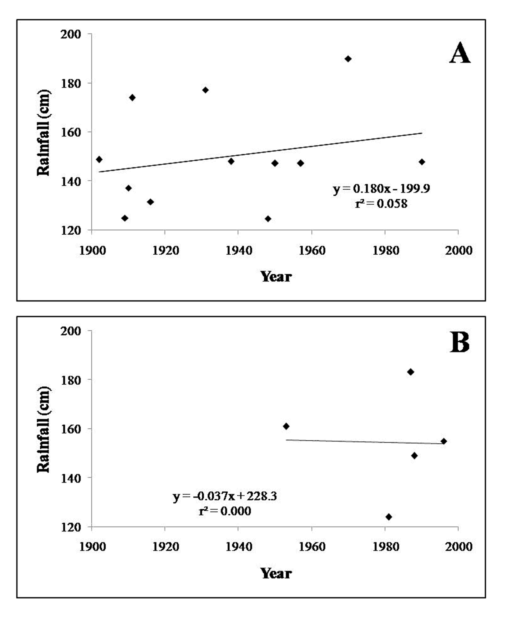
The Charas are significantly higher at the top or in the most recent sediments and therefore, suggest an increase in the high-magnitude rainfall events. The instrumental records available for Ahmednagar (near Bhatodi Tank) and Saswad (near Mastani Tank) show an increase in the heavy and extremely heavy rainfall events in the area during the recent decades (Figure 6). Surprisingly, no significant increase in the sand percentage is observed in these upper most units. This could be explained by the sequestration of coarser material by the weir constructed upstream of the Bhatodi Tank. There is no such weir upstream of the Mastani tank, but there are agricultural fields that could trap coarse sediments and allow only finer sediments to reach the tank.
Figure 6. Time series plots of the very heavy rainfall events (> 124 mm) for (A) Ahmednagar and (B) Saswad stations
An interesting point to note is that the upper units or the units immediately overlying Zone II show presence of charophytes (Figure 3 and 4). This along with the distinct textural and magnetic susceptibility characteristics suggests a major change in the hydrodynamic conditions in the lake-catchment area. Since short-term, heavy rainfall events are the basic reasons for flow of water and sediments into the tank, it is reasonable to infer that the rainfall characteristics had changed significantly during this period. The proxies used in this study, however, cannot clearly point out whether the increase in the rainfall intensity was also accompanied by an increase in the frequency and duration of the heavy rainfall events. Notwithstanding these limitations of the proxies, it is logical to state that the magnitude and return period of heavy to extreme rainfall events may have increased sometimes mid-way between the record periods. Because of the fact that the record length of the two tanks is not comparable, there is no reason to believe that the period of heavy rainfall occurred at the same time. The instrumental data also points to such non-synchronous behavior of heavy rainfall events (Figure 6). Further, considering the record length and assuming a constant rate of sedimentation, it is reasonable to argue that in both the cases the period represented by Zone II, most likely pre-dates the 20th century.
Whilst there can be some disagreement about the exact time of the period represented by Zone II, there is little doubt about the fact brought out by cluster analysis, that there is only subtle variation in the sediment characters in the upper i.e. younger sediments. It will not be unreasonable, therefore, to assume that the last century or at least the last several decades have not experienced a significant change in the rainfall characteristics. This does not necessarily imply a change in climate, because epochal changes in Indian Summer Monsoon Rainfall (ISMR) are very well known (Kripalani and Kulkarni, 1996). Epochal changes on the regional to local scale can also occur and may be non-synchronous (Gregory, 1989). The tank records most likely represent such changes.
7 . CONCLUSION
In the context of global climate changes, short-term changes on annual to century scale are considered as directly relevant to the human society. Therefore, short-term and region-specific climatic reconstructions are gaining great attention. Improved understanding of the climatic variability on annual to century scales requires natural climate archives with high resolution and good time control. In the Deccan Basalt Province such natural archives are non-existent. Therefore, in this study the deposits of two historical tanks were investigated.
The major objective of this study was to perform a multi-proxy climate reconstruction on sediment samples collected from step-trenches in two historical tanks and to understand how each tank responded to climate (mainly rainfall) changes during the last few centuries. An important observation that emerges from the present analysis is that the younger (Zone I) and older sediments (Zone III) are, by and large, very similar in terms of grain-size, mineral magnetic content and CIA. Noteworthy anomalies are observed roughly in the middle part of the section (Zone II). These sediments are associated with rainfall conditions different from the present. Since the tank inputs are governed by heavy rainfall events, the characteristics of the sediments occurring in Zone II suggest enhanced magnitude and/or frequency of such events. This does not necessarily imply a change in climate, but perhaps epochal variability in monsoon rainfall.
In summary, it could be stated that our study shows only short-term, subtle to modest changes in the hydrodynamic conditions in the catchment area during the last few centuries. It is very likely that the minor variations in the textural classes of the tank sediment indicate infrequent high magnitude rainfall events. Therefore, it is reasonable to conclude that there is no compelling evidence for major or dramatic change or shift in the climatic conditions (primarily monsoon rainfall) during the last few centuries in this part of the rain-shadow zone of the Western Ghat.
The present study is based on multi-proxy data from two historical tanks only. There are several historical tanks in the DBP that could be investigated. Synthesis of data derived from multiple historical tanks, supported by radiometric ages, may provide a better regional picture of the monsoon variability during the last few centuries on sub-decadal to decadal scale.
Tables
Figures
Conflict of Interest
The author declares that there is no conflict of interest.
Acknowledgements
The author is thankful to Prof. V. S. Kale and Prof. Nathani Basavaiah (IIG, Panvel) for guidance to carry out this work. Prof. S. N. Rajaguru and Prof. N. J. Pawar are thanked for helpful discussions. I thank Asaram Jadhav and Umesh Magar for assistance during field work.
Abbreviations
ASL: Average Sea Level; CIA: Chemical Index of Alterration; IPCC: Inter Governmental Panel on Climate Change; SPSS: Statistical Package for Social Sciences.
Band, S. and Yadava, M. G., 2020. Addressing past monsoon variability from speleothems. Curr. Sci., 119, 244-254.
3.
Basavaiah, N. and Khadkikar, A. S., 2004. Environmental magnetism and its application towards palaeomonsoon reconstruction. J. Ind. Geophys. Union, 8, 1-14.
4.
Basavaiah, N., Juyal, N., Pant, R. K., Yadava, M. G., Singhvi, A. K. and Appel, E., 2004. Late Quaternary climate changes reconstructed from mineral magnetic studies from proglacial lake deposits of Higher Central Himalaya. J. Ind. Geophys. Union, 8, 27-37.
Chauhan, M. S., Mazari, R. K. and Rajagopalan, G., 2000. Vegetation and climate in upper Spiti region, Himachal Pradesh during late Holocene. Curr. Sci., 79, 373-377.
Dearing, J. A., 1999. Holocene environmental change from magnetic proxies in lake sediments. In Maher, B. A. and R. Thompson (eds.). Quaternary Climates, Environments and Magnetism, Cambridge University Press, 231-278.
Gunaji, M., 2010. A travel guide offbeat tracks in Maharashtra, Popular Prakashan, Mumbai, 239-240.
18.
IPCC [Intergovernmental Panel on Climate Change], 2007. Climate Change: Fourth Assessment Report of the Intergovernmental Panel on Climate Change Core Writing Team, R.K Pachauri and A. Reisinger (eds.). IPCC, Geneva, Switzerland, 104.
19.
IPCC [Intergovernmental Panel on Climate Change], 2013. Climate Change 2013: The Physical Science Basis. Contribution of Working Group I to the Fifth Assessment Report of the Intergovern-mental Panel on Climate Change [Stocker, T.F., D. Qin, G.-K. Plattner, M. Tignor, S.K. Allen, J. Boschung, A. Nauels, Y. Xia, V. Bex and P.M. Midgley (eds.)]. Cambridge University Press, Cambridge, United Kingdom and New York, NY, USA, 1535.
Kale, V. S., Gupta, A., and Singhvi, A. K., 2003. Late Pleistocene-Holocene Palaeo-hydrology of monsoon Asia. In: Palaeohydrology, Understanding Global Change. K. J. Gregory and G. Benito (eds.). John Wiley and Sons Ltd, Chichester, 213-232.
Sinha, R., Singh, A. and Tandon, S., 2020. Fluvial archives of north and northwestern India as recorders of climatic signatures in the late Quaternary: Review and assessment. Curr. Sci., 119, 232-243.
46.
Srivastava, P., Kumar, A., Singh, R., Oshin, D., Kumar, A., Ray, Y., Jayangondaperumal, R., Phartiyal, B., Chahal, P., Sharma, P., Ghosh, R., Kumar, N. and Agnihotri, R., 2020. Rapid lake level fall in Pangong Tso (lake) in Ladakh, NW Himalaya: A response of late Holocene aridity. Curr. Sci., 119, 219-231.


 103m3. The tank is surrounded by high and steep hills. The altitude varies between 700 and 950m ASL. Historical records indicate that the early 18th century Maratha General, Bajirao Peshwa, built the tank around 1740AD (