1 (2017), 1, 3-8

Hydrospatial Analysis

2582-2969

Hydrologic and Geomorphic Aspects of High-magnitude Floods on the Par River in Western India

Archana Patil 1 , Priyanka Hire 2 , Pramodkumar Hire 3

1.RNC Arts, JDB Commerce and NSC Science College, Nashik Road, India

2.Department of Geography, HPT Arts and RYK Science College, Nashik, India

3.Department of Geography, HPT Arts and RYK Science College, Nashik - 422 005 (Maharashtra), India.

Dr.Pramodkumar Hire *

*.Department of Geography, HPT Arts and RYK Science College, Nashik - 422 005.

Dr.Pramodkumar Hire 1

1.Department of Geography, HPT Arts and RYK Science College, Nashik - 422 005.

08-07-2017
18-03-2017
30-05-2017
31-05-2017

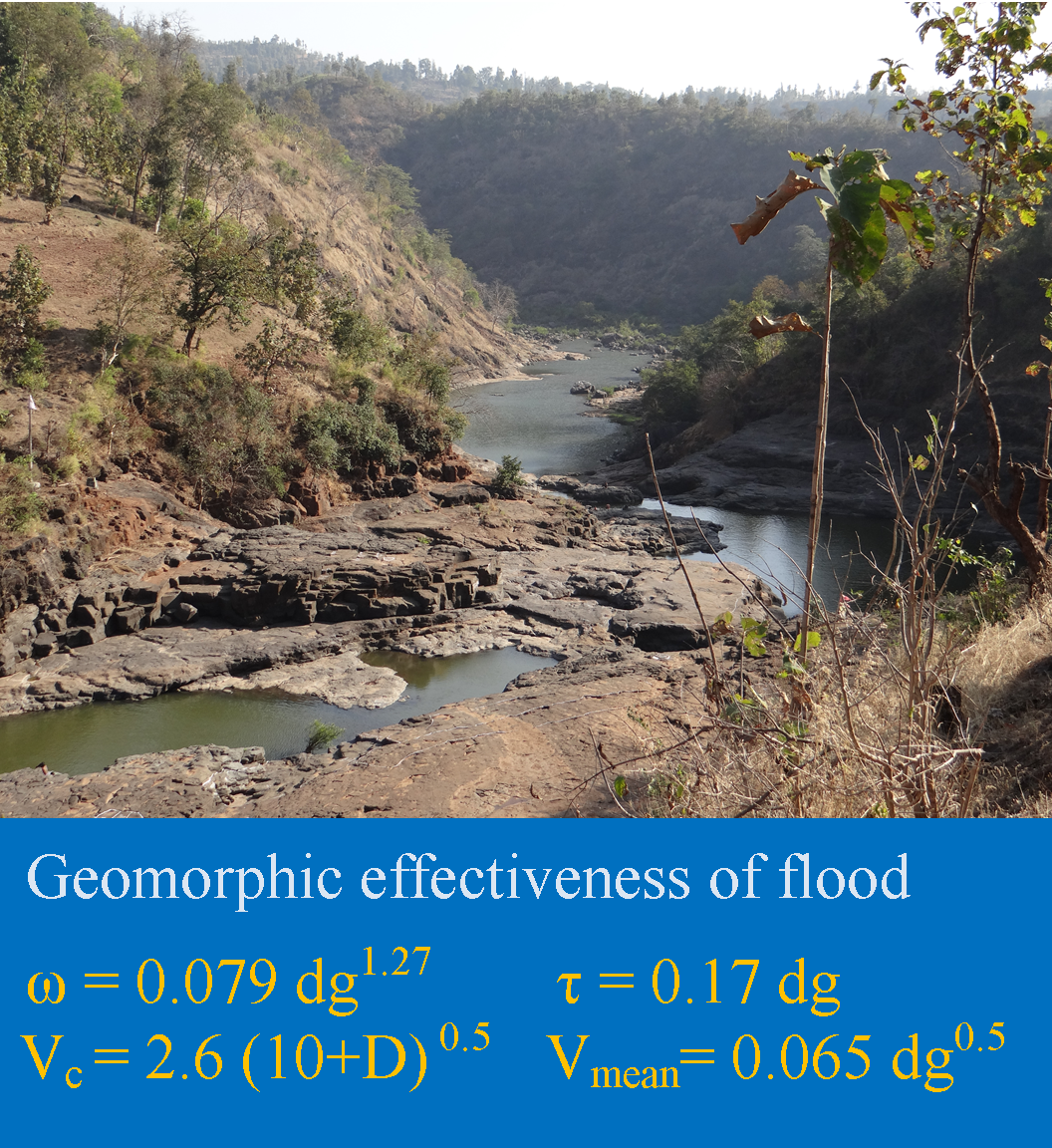
Graphical Abstract

Highlights

  1. The geomorphic effectiveness of floods is evaluated in terms of hydraulics.
  2. Flow hydraulics was obtained by calculating the hydrodynamic variables.
  3. Values reveal unusually high ability of the river to erode and transport.
  4. Efficiency of high-magnitude flood events is evident from features.

Abstract

The geomorphic effectiveness of floods is evaluated in terms of unit stream power (\(\omega\)) and boundary shear stress (\(\tau\)) for floods on the Par River. The highest values for \(\omega\) and \(\tau\) for a flood on the river are 52125 W/m2 and 3320 N/m2, respectively. The estimated Froude numbers are <1 indicating subcritical flows. It is >1 for a few constricted reaches showing supercritical or shooting flows. High values of Reynolds number reveal that the flood discharges were extremely turbulent. Values of critical velocity for the inception of cavitation (Vc) show that none of the powerful floods on the river, except two, exceed the conditions.  Estimates of \(\omega\), \(\tau\) and velocity associated with transported boulders indicate that all floods were competent to move large boulders of more than 5.5 m in diameter. The efficiency of high-magnitude flood events is evident from the presence of a variety of geomorphic features.

Keywords

Par River , Shear stress , Stream power , Geomorphic effectiveness

1 . INTRODUCTION

Bedrock channel morphology shows high spatial variability. It reveals hydraulic driving forces acting across different time scales (Baker, 1978; O’Connor et al., 1986). The alluvial channels are self-adjusted to discharges that exert the dominant influence on channel form (Leopold and Maddock, 1953). Some evidences exhibit that bedrock channel dimensions also scale with flow notwithstanding the high erosional thresholds and substrate heterogeneity in bedrock channels (Montgomery and Gran 2001; Wohl and David, 2008). Local bedrock properties, however, also influence channel morphology (Montgomery and Gran 2001). Thus, feedbacks between bedrock channel characteristics and hydraulic parameters expected to govern the balance between scaling of channel dimensions and spatial variability of channel forms by flow (Goode and Wohl, 2010).

Scientists are gradually getting acquainted with the significance of rare events like floods in shaping the landscape. These floods produce surprisingly spectacular geomorphic response (Baker and Costa, 1987). During such floods, the sediment particles lying on the channel bed of rivers are put in motion: through continual impacts, they erode the exposed bedrock. Little quantitative hydraulic data on rare floods on the Par River are available. Therefore, the analysis of local flow hydraulics and its spatial variation were obtained by calculating the hydrodynamic variables within the different segments of cross-section. We used the parameters of flood hydraulics and hydrodynamics such as stream power, shear stress, Froude number, Reynolds number and critical velocity to understand geomorphic efficacy of floods. Critical unit stream power, boundary shear stress and mean velocity values necessary to entrain cobbles and boulders were estimated on the basis of empirical relationships for coarse sediment transport.

2 . PAR RIVER: GEOMORPHIC, GEOLOGIC AND CLIMATIC SETTINGS

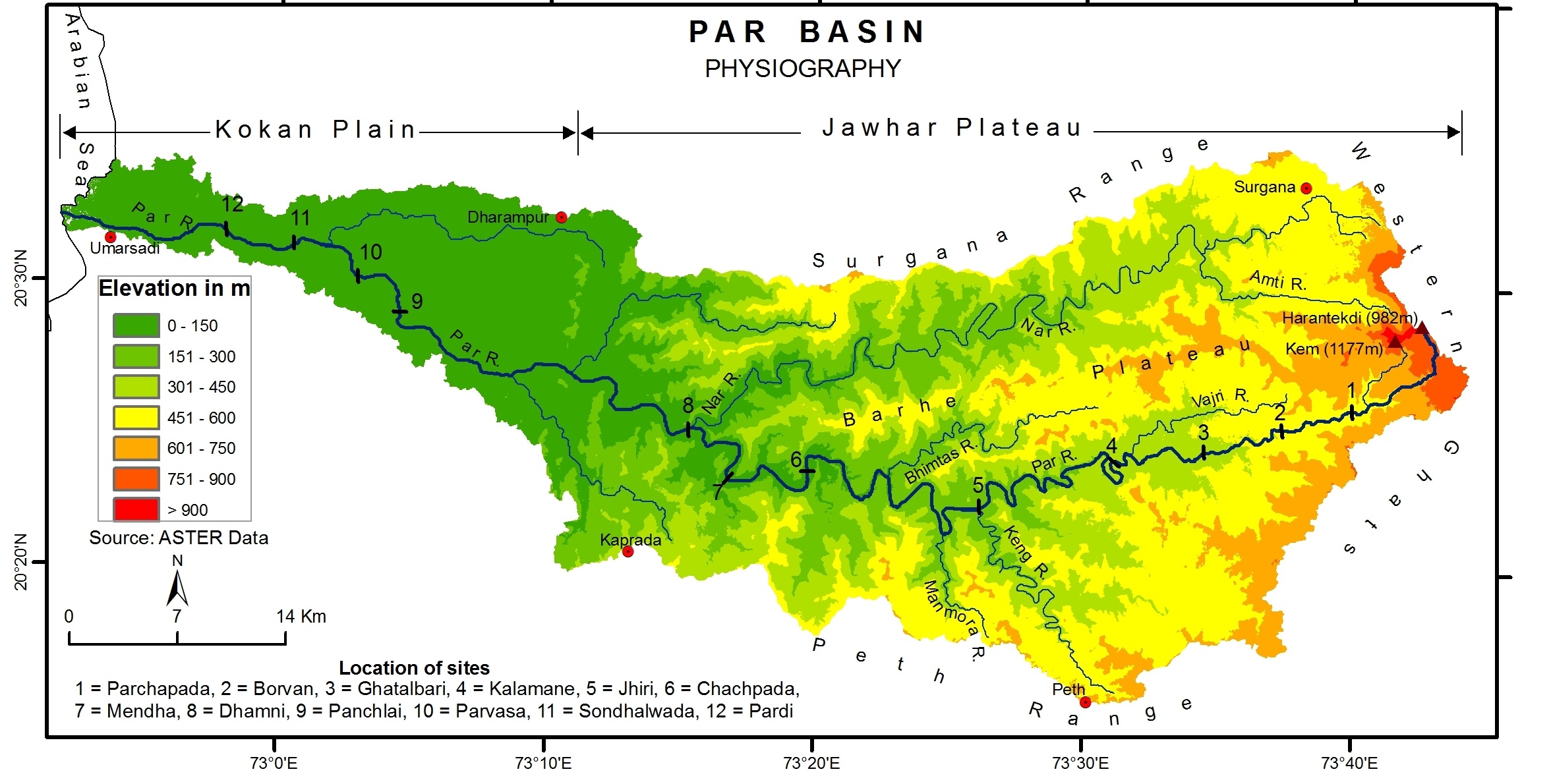
The Par River from Western India has been selected for study of flood hydraulics and hydrodynamics high-magnitude floods (Figure 1). It has its source near Harantekadi at an elevation of 982m ASL. It flows to the West through Maharashtra (46.45% area) and Gujarat (53.55% area) States and drains into the Arabian Sea near Umarsadi in the Gujarat State. The length of the river is 142 km. The drainage area of the Par River is 1664 km2.  The Nar River, with the length of 87 km, is the major tributary of the Par River and joins from the North. Physiographically, upper Par River and its tributaries flow on the Jawhar Plateau whereas lower river flows on the Kokan Plains (Figure 1). 

Figure 1. Geomorphic Map of the Par Basin

The entire basin is underlain by horizontally bedded Cretaceous-Eocene Deccan Trap basalts (Mahoney et al., 2002). The river has single, sinuous, and well-defined channel, incised into bedrock. The channel floor is either of bedrock or covered by pebbly/cobbly material or boulders. The alluvial channel, with tidal effect, is seen only in lower reaches for seven km from the mouth. 

The Par River and its tributaries are South-West summer monsoon fed (June to September).  The average annual rainfall in the basin is 2076 mm and 93% of the annual rainfall occurs during South-West monsoon season. The basin occasionally receives heavy rains due to cyclonic storms and depressions originating over the Bay of Bengal or adjoining land and the Arabian Sea.

3 . DATA AND METHODOLOGY

The cross sectional and channel slope data for rare floods for a dozen reaches (Figure 1) from source to mouth were used for calculating hydraulic parameters. The geomorphic effectiveness of a flood, which relates to its ability to affect the form of the landscape (Wolman and Gerson, 1978), is commonly linked to flood power and the degree of turbulence (Baker and Costa, 1987; Wohl, 1993; Baker and Kale, 1998; Kale and Hire, 2004; Hire and Kale, 2006; Kale and Hire, 2007). Therefore, for the known rare flood events, boundary shear stress, stream power per unit boundary area, Froude number and Reynolds number were computed with the help of following formulae (equations 1, 2, 3 and 4) (Leopold et al., 1964; Baker and Costa, 1987):

\(\tau\)   = \(\gamma\)RS                          (1)

\(\omega\)  = \(\gamma\)QS/w                       (2)

Fr = \(V_{mean}\)/ (gR)0.5          (3)

Re = \(V_{mean}\)R / n               (4)

where, \(\tau\) is boundary shear stress expressed in Newton per square meter (N/m2), \(\gamma\) is specific weight of clear water (9800 N/m2), R is hydraulic radius or mean depth of water in m, S is channel slope, \(\omega\) is unit stream power expressed in watts per square meter (W/m2), Q is discharge in m3/s, w is the water surface width in m, Fr is Froude number, \(V_{mean}\) is mean flow velocity in m/s, g is acceleration due to gravity (9.8 m/s2), Re is Reynolds number, n is kinematic viscosity (1 x 10⁻⁷ m2/s for water temperature of 20o C) (Leopold et al., 1964; Petts and Foster, 1985).

Another related measure of erosional power of flows is critical velocity for inception of cavitation (Vc) (equation 5).  The critical velocity for inception of cavitation in m/s is given by Baker (1973) and Baker and Costa (1987).     

Vc = 2.6 (10+D) 0.5          (5)                 

where, Vc is the critical velocity for the inception of cavitation in m/s and D is flow depth.

The channel bed of the Par River is dominated by boulders at various locations. Therefore, in order to evaluate the mobility of these coarse sediment theoretically, the sediment-transport equations developed by Williams (1983) were used, and the approximate minimum critical values of bed shear stress (\(\tau\)) (equation 6), unit stream power (\(\omega\)) (equation 7), and mean velocity ( \(V_{mean}\) ) (equation 8) that could initiate cobble and boulder movement were estimated. The equations used in the boulder transport calculations are as follows:

\(\tau\) = 0.17 dg                         (6)

\(\omega\) = 0.079 dg1.27                       (7)

\(V_{mean}\) = 0.065 dg0.5             (8)

where, dg is the intermediate diameter of the grain in mm.

4 . RESULTS AND DISCUSSION

The discharges for the rare floods on the Par River range from 2427 to 38006 m3/s (Table 1). These are large rainfall-runoff floods measured by indirect methods. These discharges stand out as high outlier of maximum floods per unit drainage area when compared with those recorded in the world. From the reconstructed hydraulic data, unit stream power and bed shear stress range between 616 and 52125 W/m2, and 125 and 3320 N/m2, respectively (Table 1). These values reveal unusually high ability of the river to erode and transport sediments. These estimates and the hydraulic characteristics of the Par River further suggest that high flows can easily move cobbles in suspension, and large boulders as bedload (Baker and Costa, 1987). In the bedrock channels, such as the Par River, the unit stream power and bed shear stress values are higher by several orders of magnitude than those that occur in the alluvial channels (Kale et al., 1994; Rajaguru et al., 1995; Baker and Kale, 1998).

Table 1. Hydraulic parameters of rare floods on the Par River.


Site


Discharge


(Q)

m3/s

Width


(W)

m

Depth


(D)

m

Slope


(S)

Velocity

(\(V_{mean}\))

m/s

Shear

stress

(\(\tau\))

N/m2

Stream

Power

(\(\omega\))

W/m2


Fr


Re x
107


Vc

m/s

Parchapada

3614

110

7.16

0.01294

6.99

596

4166

1.03

33

10.77

Borvan

2708

113

6.31

0.00883

6.16

381

2082

0.93

27

10.48

Ghatalbari

2427

109

6.64

0.00326

5.05

141

713

0.77

22

10.61

Kalmane

9710

95

9.73

0.05204

15.70

3320

52125

1.96

102

11.54

Jhiri

3955

154

9.43

0.00244

4.91

125

616

0.69

26

11.47

Chachpada

5954

88

11.70

0.00560

9.22

405

3734

1.08

68

11.22

Menda

20056

42

28.80

0.00816

16.62

2306

38322

0.99

479

16.12

Dhamni

21775

240

14.00

0.00115

6.46

159

1024

0.55

91

13.77

Panchlai

35785

371

12.90

0.01097

10.67

972

10370

1.13

96

12.43

Parvas

38006

372

18.90

0.00269

7.20

374

2693

0.61

102

14.04

Sudhalvada

10699

290

9.98

0.00375

5.86

232

1356

0.75

37

11.60

Pardi

25732

390

15.90

0.00111

5.60

128

717

0.64

66

13.24

In addition to above estimates, the analysis indicates that the Froude number greater than or close to 1 (supercritical flow) has been reached on several occasions on the river (Table 1).  Intense bedrock scouring, resulting from cavitating flow conditions is also reflected by erosional features such as flute marks, polished rock surfaces and pot holes (Baker, 1988; Kale et al., 1993; Kale et al., 1994). Supercritical flow is more common in bedrock channels and can be sustained for longer period of time. However, as the depth of water increases to 10-15 m, the flows are so deep that the formation of supercritical flow is then suppressed (Baker and Costa, 1987).  High values of Reynolds number indicate that the flood discharges could be extremely turbulent, and thus, are capable of accomplishing a variety of geomorphic activities. The deep narrow reach at Mendha (Table 1; Figure 2) produce the highest Reynolds number, and it is likely that this may be the reach of very high and intense bedrock erosion. Such erosional power of the flood flows is also evident from the presence of scablands, waterfalls, inner channels, plunge pools, and large boulder berms on the river. 

Figure 2. Kalmane Gorge showing narrow and deep bedrock channel in dry season

Another related measure of the erosional power of the flows is the critical velocity for the inception of cavitation (Vc). Estimates of the values indicate that none of the powerful floods on the Par River exceed the conditions expressed by the equation 5 except at Kalmane and Mendha. This, therefore, suggests that channel adjustment produced by cavitation tend to inhibit or reduce the forces that would cause the threshold to be crossed in nature (Baker and Costa, 1987). The Kalmane (Figure 2) and Mendha (Figure 3) reaches are deep narrow gorges where inception of cavitation is possible. 

Figure 3. A view of the deep narrow Mendha Gorge on the Par River in dry season. The gorge is 500 m long, 42 m wide and 60 m deep. Flow direction is from bottom to top of the photograph

The presence of large boulders along the Par River provides some evidence to the competence of the flows (Figure 4). Using the empirical relationships  (equation 6-8) developed by Williams (1983), the threshold values of bed shear stress, unit stream power, and mean velocity necessary to transport the boulders were calculated (Table 2). The estimated values, when compared with the values of bed shear stress, unit stream power, and mean velocity generated by reconstructions of flows, reveal that the river flows are several orders of magnitude higher than the threshold values for the entrainment of boulders. The calculated figures further suggest that floods are competent to transport the largest ever recorded boulder present on the channel bed. This is particularly true for the Par River having bedrock channel. 

Table 2. Boulder and flow competence data.

Site

Intermediate axis


mm

Velocity

( \(V_{mean}\) )

m/s

Shear stress

(\(\tau\))

N/m2

Stream Power

(\(\omega\))

W/m2

Borvan

800

1.84

136

384

Jhiri

540

1.51

92

233

Dhamni

400

1.3

68

159

Panchlai

1100

2.2

187

575

Parvasa

660

1.66

112

301

Sudhalvada

800

1.84

136

384


Figure 4. An imbricated isolated boulder transported by a large flood in a wide shallow channel at Panchalai

5 . CONCLUSIONS

Bedrock channel morphology of the Par River shows high spatial variability in terms of flood hydraulics and hydrodynamics. The higher values for unit stream power and boundary shear stress for rare floods on the Par River reveal unusually high ability of the river to erode and transport sediments. The estimated Froude numbers for majority of sites, as expected, are less than 1, indicating that the flows were dominantly subcritical. However, the Froude numbers were greater than 1 for a few constricted reaches of the bedrock channel showing that the flows were supercritical or shooting. High values of Reynolds number indicate that the flood discharges could be extremely turbulent, and thus, are capable of accomplishing a variety of geomorphic activities. Estimated values of critical velocity for the inception of cavitation (Vc) indicate that none of the powerful floods on the Par River, except two, exceed the conditions for inception of cavitation.  This, therefore, suggests that the process of cavitation is confined only to very narrow, steep reaches during extraordinary floods, which occur at a much longer interval. Theoretical estimates of unit stream power, shear stress and velocity associated with transported large boulders indicate that all floods on the Par River are competent to move large boulders present in the Par River.  The efficiency of high-magnitude flood events is also evident from the presence of wide shallow bedrock channels, scablands, deep narrow gorges, grooves, polished rock surfaces, waterfalls, inner channels, plunge pools, and large boulder berms at several locations on the Par River.

Conflict of Interest

The authors declare no conflict of interest.

Acknowledgements

Dr. Pramodkumar S. Hire is grateful to Board of College and University Development, Savitribai Phule Pune University, Pune for financial support to conduct this research work (Project Number: 14SCI000138 sanctioned on March, 11, 2015). The authors are thankful to Professor Vishwas S. Kale for his helpful and constructive comments and suggestions. Authors are grateful to Mr. Rajendra Gunjal,   Mr. Uttam Pawar, Mr. Laxam Shendge, Mr. Abhijit Borse and Mr. Prasad Patil for their support in the field.

Abbreviations

ASL: Above Sea Level

References

1.

Baker, V.R., 1973. Erosional form and processes for the catastrophic Pleistocene Missoula floods in eastern Washington. Morisawa M. (Ed.), Fluvial Geomorphology. George Allen and Unwin, London, 123-148.

2.

Baker, V.R., 1978. Palaeohydraulics and hydrodynamics of scabland floods. Baker, V.R., Nummedal D. (Ed.), The Channeled scabland: Washington, D.C., National Aeronautics and Space Administration, 59-79.

3.

Baker, V.R. and Costa, J.E., 1987. Flood power. Mayer, L., Nash, D. (Eds.), Catastrophic Flooding. Allen and Unwin, London, 1-21.

7.

Hire, P.S. and Kale, V.S., 2006. Geomorphic effectiveness of high-magnitude floods on the Tapi River: Evaluation based on flood hydrographs and stream-power graphs. Transactions. Institute of Indian Geographers, 28(2), 175-182.

11.

Kale, V.S., Mishra, S., Enzel, Y., Ely, L.L., Rajaguru, S.N. and Baker, V.R., 1993. Flood geomorphology of Indian peninsular rivers. Journal of Applied Hydrology, 6, 49-55.

13.

Leopold, L.B., Wolman, M.G., Miller, J.P., 1964. Fluvial process in geomorphology. Freeman, San Francisco.

18.

Rajaguru, S.N., Gupta, A., Kale, V.S., Mishtra. S., Ganjoo, R.K., Ely, L.L., Enzel, Y. and Baker, V.R., 1995. Channel form and process of flood-dominated Narmada River, India. Earth Surface Processes and Landforms, 20, 407-421.