This study aims to propose suitable solutions to restore the river and control its water pollution.
The data were collected from the questioner surveys, key informant interviews, and focus group discussions.
The design approach and policy measures were developed based on the perceptions of local community people, experts and government officials.
Three river-front plans are suggested for development of the Ichamati in Pabna, Bangladesh.
Abstract
Rivers are the lifeline of Bangladesh economy and serve as the source of water supply, fisheries, irrigation for agriculture, low-cost transport, generate electricity and conserve biodiversity. The Ichamati River situated in Pabna, Bangladesh is also a blessing for the city. However, recently, due to the irregular and unplanned activities adjacent to the riverside, the life, flow and water quality of the river is in a vulnerable condition. This study aims to identify the present status of the Ichamati River and provide an effective design approach and policy measures in restoring the river flow and control water pollution. The data was collected from the questioner surveys, key informant interviews and focus group discussions. Results suggest that several factors such as the construction of an illegal settlement, unplanned waste dumping, disposal of fiscal sludge through sewerage connection, lack of awareness among people regarding the importance of river biodiversity and absence of riverfront development and conservation plan are responsible for water pollution, inconsistent water flow and damaging the life cycle of Ichamati river. The design approach and policy measures were developed based on the perceptions of local community people, experts and government officials. The suggested policy measures will help to restore the flow of the river and reduce the water pollution, and the design approach will ensure the economic benefit of the riverfront development in future.
Keywords
Waste Dumping , Development plan , Visitor attraction , Economic Return , Urban , River , City
1 . INTRODUCTION
The river is an essential part of urban planning and ecosystem in different cities around the world for centuries (Brunn et al., 2003). Rivers affect human life and perform a variety of functions relating to commerce, defense, transport, communication, and culture (Sami et al., 2000; Nienhuis and Leuven, 2001; Uddin, 2015). The current relationship between river and city takes on an entirely different aspect and is viewed through the lens of beauty that forms the urban environment and is a critical element in integrating its inhabitants (Sami et al., 2000; Pracheil et al., 2013). It impacts the economic structure of the region, for example, by growing tourism and investment (Alam, 2003). Rivers also provide an impetus for the implementation of various architectural and urban projects. These projects integrate the riverfront design with space and ensuring the future viability of the riverside (Alam, 2003; Gain, 2014; Kabir et al., 2015).
Bangladesh has large inland water bodies crisscrossing its low lying flatlands. Bangladesh comprises some of the rivers in the world which are incredibly vulnerable owing to its geographical characteristics (Alam, 2002; Siddiquee and Hoque, 2007; Kafy et al., 2019). Recently, these rivers are facing many threats due to natural and human-made activities which might cause extinction in the near future. Brookfield (1988) highlights the rapid urbanization process near the riverside area as one of the causes that change the current terrain and landscape without thinking of likely consequences and requirements to sustain the environment and ecology. Industrialization near the side of rivers has created massive pollution problems (Brookfield, 1988; Teclaff and Teclaff, 1994; Nienhuis and Leuven, 2001). One of the negative consequences of ongoing urban expansion during the industrialization period is the disruption of the ecological balance of large cities (Pijanowski et al. 2000; Rahman et al., 2012). Urgent problems of imbalanced development were particularly apparent in riverside areas, which were subjected continuously to intensive landscape transformation, often with irreversible changes (Karl et al., 1988; Meyer and Turner, 1992; McKinney, 2002). As a result, the current status of riverside areas in most linear cities are characterized by their inefficient use, along with a significant degree of disturbance of riverside landscapes (Pijanowski et al., 2000; Zhou et al., 2011; Kafy et al., 2019).
Pabna is one of the cities in Bangladesh where natural resources such as rivers and surface water bodies have significantly decreased. For a long time, the prevailing method of city development was the gradual filling of most favorable riverside areas with industrial, transport facilities and residential areas, without using any transformation strategy (Ahmed and Roy, 2007; Siddiquee and Hoque, 2007; Ali, 2014). It has led to a situation where the city which occupied naturally favorable areas along the Ichamati River faced the problem of connection between remote parts of the city and riverside areas (Mondal and Bandyopadhyay, 2014; Mondal and Satpati, 2015; Mondal et al., 2016). An essential resource for implementation of ecological reconstruction of the urban environment is laid in the city plan: Pabna city spread its development along the bank of the river (Ali, 2014; Chakma and Chakrabartty, 2017). The main functional zones have been formed near the urban riverside area, and this area has the potentiality to be connected between the urban environment and the river (Karl et al., 1988; Brunn etal., 2003). However, the mechanism of “re-naturalization” of riverside areas (restoration of lost components of nature) has become urgent for realizing their ecological and landscape potential. It’s the constitution of the essence of the proposed eco-urban planning optimization (Pracheil et al., 2013; Ginzarly, 2014; Mondal and Bandyopadhyay, 2014; Uddin, 2015; Freiman, 2019). Various aspects of interaction between the city and natural landscapes are formed for the transformation of riverside area: (a) socio-economic recovery, (b) increased recreational capacity, (c) increased attractiveness of investment, (d) prevention of polluting river water and (e) environmentally sustainable climate for water ecosystems (Stanford et al., 1996; Ali, 2014; Gain and Giupponi, 2014; Mondal and Satpati, 2015; Chakma and Chakrabartty, 2017; Kafy, 2018; Kafy et al., 2019; Kafy et al., 2020).
Several terminologies were used to define a range of steps to restore the rivers. In the background of the protection of the river, Kabir at el. (2015) investigated Halda’s biodiversity and ecosystem services in collaboration with the river-dependent society and challenges (Kabir et al., 2015). Ahmed and Roy (2007) address the problems encountered due to water shortage and the importance of collaboration among the co-basin countries, as well as the proper utilization and conservation of water resources. Alam (2008) conducted a cost-benefit analysis to determine the economic efficiency of Bangladesh’s dying river, namely the Buriganga River. Using market data and using value transfer and contingent assessment methods, the advantages of the restoration system are extracted (Alam, 2008). In this study, the proposed solutions for the restoration of river estimated based on perceptions of local people and suggestions from local governmental organizations. The research conducted based on the data collected from the questioner surveys, key informant interviews and focus group discussions.
To demonstrate the importance of the river ecosystem, primary objective of this study was to identify the existing scenario of the Ichamati River and propose effective policies and design approaches for ensuring sustainable riverside development. The clarifications mainly focus on restricting the unplanned use of riverside, eliminate illegal settlements, and introduce user-friendly recreational spaces that will provide an economic return.
2 . STUDY AREA
Since the present condition of the Ichamati river is at a very alarming rate day by day. It has become urgent to protect the river. For this reason, a recreational place proposal has been made to restore the river’s condition and to keep the environment around the river friendly, as well as to maintain the biodiversity of the river.
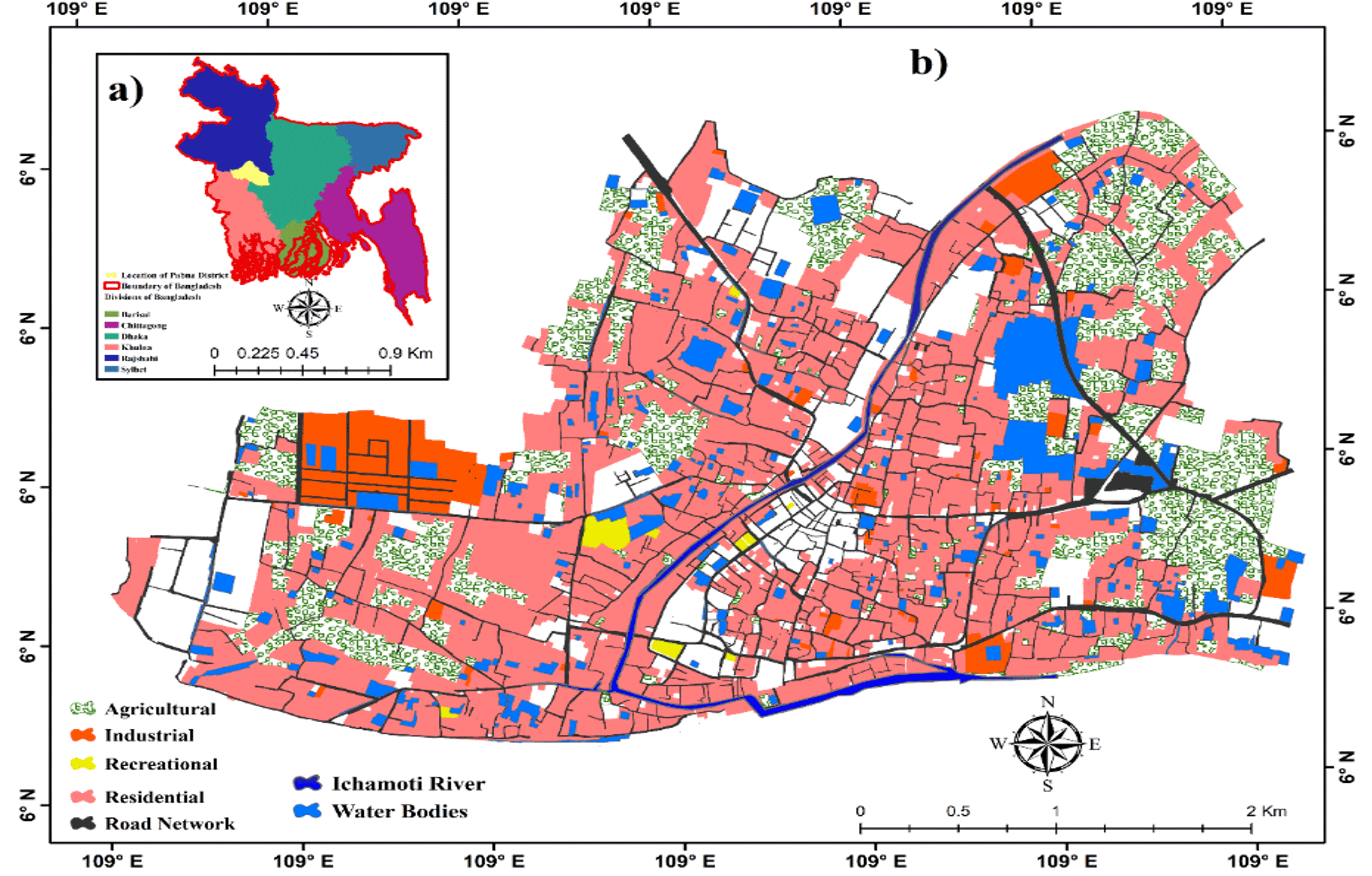
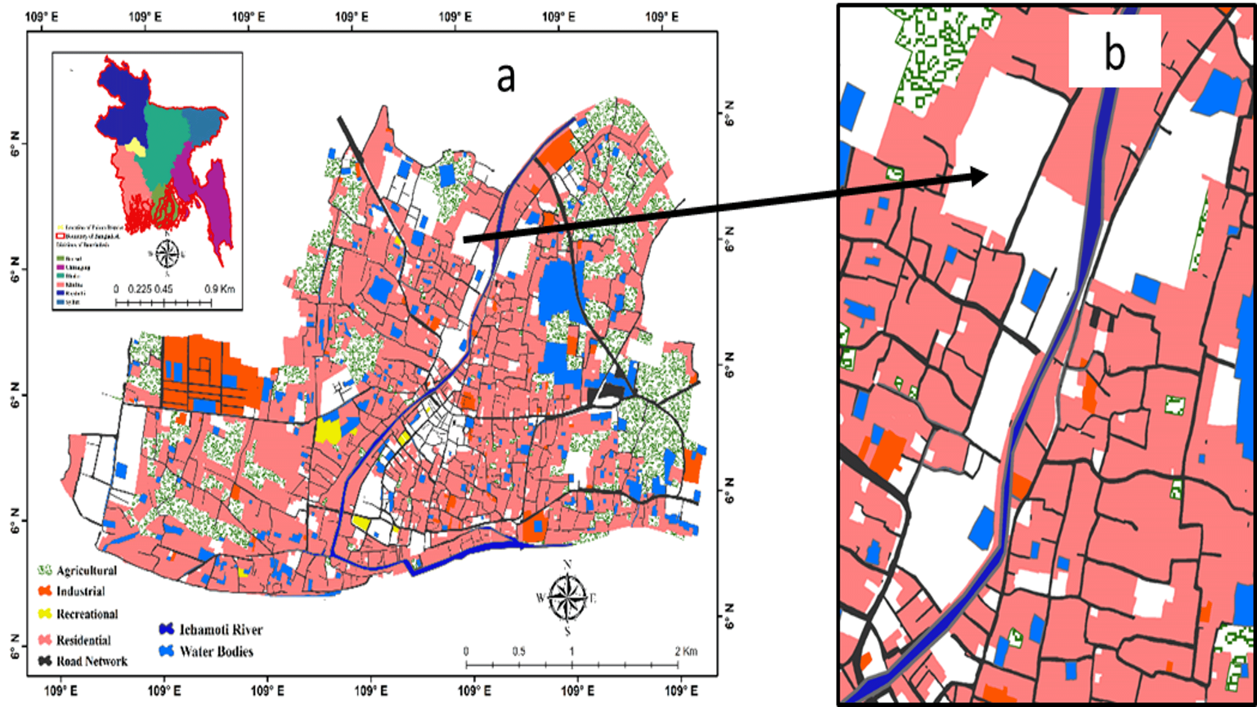
Pabna, one of the oldest districts in Bangladesh’s, was formed in 1832. The area of Pabna district is 2372 km2, located between 23º48" and 24º21" N and between 89º00" and 89º44" E (Figure 1). Various rivers and canals are flowing through the district. Padma (Ganges), Kamala, Ichamati, and Pati Beel are the major water bodies. Several other rivers pass through the region, but in summer, they are almost dry and are not navigable except during the rainy season. The Ichamati, the Hurasagar, the Baral, and the Chiknai are distributors that come from one major river and fall into another.
Figure 1. Location of Ichamati River
The work was performed for the Ichamati River, which is one of the most important wetlands in the Pabna district. It was famous for its reserve of aquatic life. It is 30 km2, in length, the average width is 100 m, and its water area 412 ha. From January to May, it remains inundated with water supplied by water pumping station to a depth up to 6-7.5 m and the remaining months around the 4.5 m depth. But the study area of this research is about 30km. The river was being used as an irrigation canal for the supply of water for agriculture and fisheries.
The review shows that the Ichamati River has lost its navigability. The river is almost dead, and no fish exists in the river. The minimum amount of water in the river is also very malodorous and inappropriate for use. Household wastes are drained into the river, and poisonous chemicals from nearby small factories mixed with water make the water black. Now the river is not coming to any benefit of the people, and day by day, people are occupying rivers and building illegal structures. As a result, the breadth of the river is decreasing and gradually becoming a drain of waste water.
Nevertheless, the areas along the river have some strength. The large available open space and its natural resources are the main strength of this area. Besides, area near to CBD and good accessibility are its opportunity. Also, deficient pedestrian pathways and insecurity are the weakness of the area. All this information will help to build a suitable recreational center on the banks of the river.
3 . MATERIALS AND METHODS
This study was based on primary as well as secondary sources of data. The primary data were collected from the household questionnaire survey and participatory rapid appraisal (PRA) tools. In the household questionnaire survey, 200 households were surveyed with the help of a structural questionnaire prepared based on socio-economic, demographic, livelihood characteristics, dependency on the river, and activity patterns of the riverside people.
For ensuring public participation, PRA tools such as Key Informants Interview (KII) and Focus Group Discussion (FGD) were conducted. Thirty (30) KII were done consist of several local experts in a different fields such as city officials, urban planning, policymakers, and environmental engineers. Five FGD were held including local participants such as community people, local political leaders, NGO representatives, farmers and fishermen.
The secondary data were collected from different journals, websites, and Government Offices. Data related to climate and river (temperature, river flow, and environmental issues, etc.) were collected from the Bangladesh Meteorological Department, River Research Institute and Water Development Board.
The collected data from different sources were organized in SPSS, Excel, and Arc GIS, 10.6 V for mapping. Finally, considering all the data and suggestions from community people, a suitable design was proposed using auto cad and sketch up software. The research concluded with some useful recommendations about the restoration of endangered rivers in a different region of Bangladesh.
4 . RESULTS AND DISCUSSIONS
This section briefly discusses the demographic and economic characteristics, factors contributing to the river water pollution and obstruction in the river channel flow and recreational demand of Ichamati River.
4.1 Demographic Characteristics
Demographic characteristics most commonly used in public health statistics include age, gender, race, ethnicity, geographic area, and educational attainment (Birdsall et al., 2001; Kafy et al., 2019). Based on the survey conducted in the study region, it was found that most of the people living on the bank of the Ichamati River are bachelors. About 55% of the people living along the river are bachelors, while the rest live in the family. The weightage of the bachelor’s respondents is highest because the study region is a suitable place for accommodation of the job holders, university and college students situated nearby of the riverside.
The rivers of a region are mainly polluted by the activities of the people living in those regions. This can be understood by looking at the overall picture of the Ichamati River in Pabna city. The level of pollution is mainly observed by the long-term effects of human habitation.
The people are newcomers and have been living here for less than 5 years (Table 1). Of all these newcomers, 68.67% are bachelors. The remaining 35.8% of the family has been living here for 10-20 years. Only 12.05% are bachelors who have been living in these riverine areas for more than 20 years.
Table 1. Marital status of the inhabitants
Marital status
Age groups
<5 years
10 to 20 years
>20 years
Family (%)
19.40
35.80
44.80
Bachelor (%)
68.67
19.28
12.05
4.2 Socio-economic Characteristics
Socio-economic characteristics are concerned with the interaction between social and economic factors within society. This factor influences how a particular community or socio-economic class acts within society and their behavior as customers. Different socio-economic groups may have different priorities as to how they channelize their funds (Birdsall et al., 2001; Kafy et al., 2019). It is estimated that most of these bachelors and families are students and service holders. About 49.40% of the bachelors are students, and 43.30% of the families are service holders. Also, some of the people are businessmen and housewives.
Four categories of people live beside the Ichamati riverfront area (Table 2). Most of them have a monthly income of 1K BDT-15K BDT, and 78.30% of them are students. About 18.20% of households have no income. And very few students have a monthly income level of 15 BDT-25 BDT. The monthly income of 20.5% service holders is between 1K BDT and 15K BDT. About 41.80% service holder’s monthly income was 15K BDT-25K BDT and 33.3% monthly income of people in business are 25K BDT-40K BDT, with 25% of businesspeople have a monthly income of more than 40K BDT.
Table 2. Economic status of the inhabitants
Occupation
Income Range (BDT)
No income
1-15K
15K-25K
25K-40K
>40K
Student (%)
5
78
14
3
0
Housewife (%)
82
12
0
0
0
Businessman (%)
0
17
25
33
25
Service holder (%)
0
27
42
30
12
It is estimated that most of the family members living near to riverbank are 4 to 5 persons. From business families, 33.3% of family members are 4 persons. From service holder families, 14.5% of family members are 4 persons. And 11.7% of the students have family members of 5 persons. It is also understood that the number of working and business family members is usually the highest among the families living along the river.
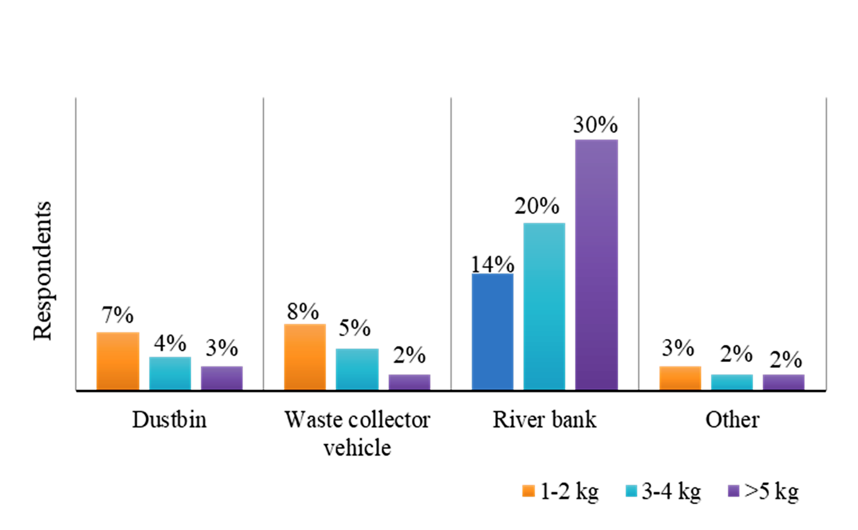
4.3 Waste Generation and Dumping Locations
Dumping of household wastes is one of the main reasons responsible for the pollution of the Ichamati River water. According to the respondent, the dumping of bulk of the waste happened in and beside the riverbank side. From Figure 2, it can be seen that people living along the river produce more than 5 kg of waste every day. And the last address for those wastes is the river bank. An average 30% of people produces more than 5 kg of waste every day and dump that waste into the river. About 20% of the people produce an average of 3 to 5 kg of garbage every day and throw it into the river. Only 2% of people produce more than 5 kg of waste, but they leave it to the waste collection vehicle.
Figure 2. Amount of waste and dumping location
4.4 Sewerage Connectivity and Dumping Locations
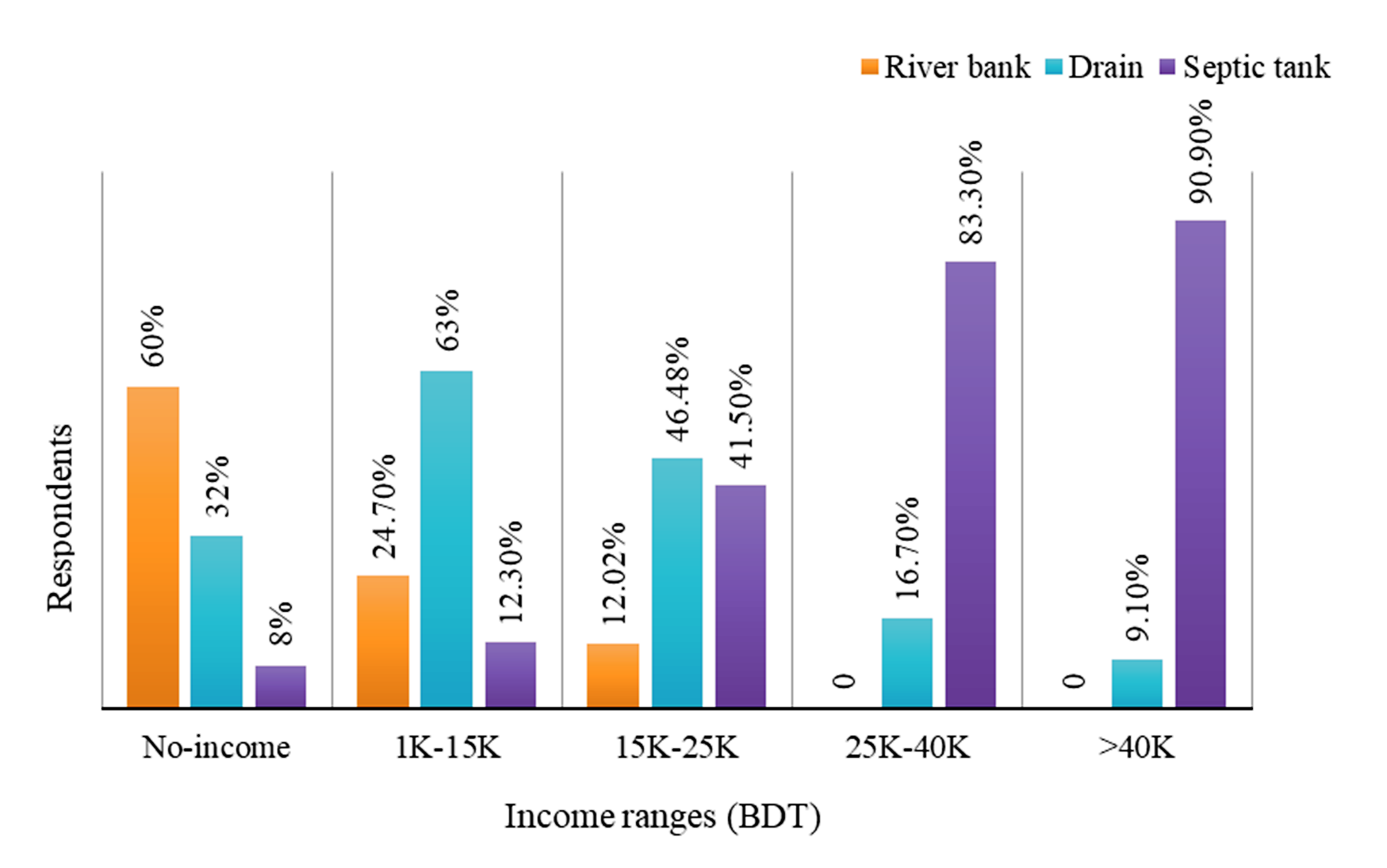
Maximum people in the study area have a sewerage connection directly linked with the river. This improper dumping was already affecting the river morphology and creating an ecological imbalance in the city. Factors like occupation and income have a significant impact on the sewerage connection network. People with good income and standard educational background are aware of illegal sewerage connectivity directly to the river and in maximum situation use their own septic tank for the sewerage disposal (Figure 3). Generally, no income people are more likely to throw sewerage waste into the river and drain among people in the group. About 60% of the no income group people dump sewerage waste directly into the river bank. About 32% of no income group people throw their sewerage waste into the drain. Besides, the tendency of using the septic tanks is more noticeable among those whose income ranges between 25K BDT and 40K BDT.
Figure 3. Income wise sewerage connection beside the Ichamati River
4.5 Fisheries
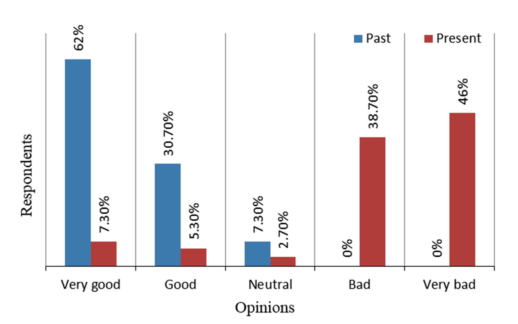
Since the river is only one component of a larger ecosystem, fishing communities in rivers are affected not only by events occurring within the channel associated with water but also by a range of external influences (Kolas et al., 2000; Loucks, 2000; Walmsley and Pearce, 2010). Precipitation falling within the basin eventually finds its way into the river by surface and subsurface flow, carrying a variety of materials that significantly affect the fisheries’ characteristics in the river. Changing conditions in the reservoir can cause differences in water quality, quantity, and loading the silt and other content into the river that may directly affect the fishing structure (Kolas et al., 2000; Bagheri and Hjorth, 2007; Mays, 2007; Kafy, 2018; Kafy et al., 2018). The level of river pollution significantly hampers the inland fisheries (Figure 4). About 62% of the people said that the condition of fisheries in river was very good in the past where at present, 46% of the people believed that the current situation of fisheries is bad or very bad.
Figure 4. Fisheries in the Ichamati River
4.6 Water Quality of Ichamati River
River water originates from natural sources and used by humans for various purposes since ancient times. But gradually, it has become contaminated and unfit for human consumption (Gleick, 2000; Loucks, 2000; Chan et al., 2016; Roy et al., 2018). According to opinion of the people, condition of the water in Ichamati River demonstrates that the waste dumped into the river has gradually taken the river to its final stage of pollution. After compiling the responses, the water quality of the river, it is found that the river water is now very fragile and unusable. In the opinion of 53% people, the river water is now polluted and dirty. 31% of people have expressed their opinion that the river water quality malicious with no positive comments regarding the cleanness of the river water (Table 3).
Table 3. The present situation of river water
Water quality
%
Clean and pure
0
Odor and impure
53
Malicious
31
Clouding
16
4.7 Factors Affecting Obstruction of the Ichamati River Flow
Several factors contribute significantly for obstructing the natural river flow. The obstruction dramatically reduces the river biodiversity and the effectiveness of natural resources for ensuring a sustainable community (Brookfield, 1988; Nienhuis and Leuven, 2001; Kafy et al., 2018). The illegal construction beside the river banks, filling up the river, dam construction without considering the river biodiversity are few of them. Based on people’s perception, four major indicators play a significant role in the present tragedy of the river (Table 4). Most of these people gave their opinion on digging the soil (37%), and construction of boundary walls (28%) around the riverside is mostly responsible for this situation. For ensuring river sustainability, strict measures need to be taken in the reduction of obstacles that significantly affect the flow of river water.
Table 4. Factors affecting obstruction in river flow
Obstruction factors
%
Boundary wall
28
Dam
15
Soil Digging
37
Others
20
4.8 Factors Effecting Filling up River Channel
Many factors are contributing to a river dead. The dying of the river represents weak city management in conserving natural resources. The river flow beside or within a city represents the culture of a city. Therefore, to preserve the culture of a city, it is essential to restore the river biodiversity (Stanford et al., 1996; Alam, 2002; Pracheil et al., 2013; Kabir et al., 2015; Mondal and Satpati, 2015). Ichamati River in Pabna shows gradually conversion into drain of the waste water. Several factors are responsible for filling up the river (Table 5). About 42.7% of the respondents are blaming unplanned industrialization and urbanization in the riverside for filling up the Ichamati River. About 32.7% of people attribute sewerage, civic waste, and inadequate management to the cause of river erosion. Whereas, 24.6% of people identified sewerage, non-biodegradable waste, and inadequate management systems as the cause of river fill up.
Table 5. Factors effecting filling up
Cause
%
Sewerage, civic waste, and inadequate management
32.7
Unplanned industrialization and unplanned urbanization
42.7
Sewerage, non-biodegradable waste, and inadequate management
24.6
4.9 Major Sources of River Pollution
The immoral activities of people from the city are the main cause of river pollution. Pollutant materials coming from different sources mix into the river and pollute the river water. Most of the time, the source of these contaminants is from homes and factories (Solanes and Villarreal, 1999; Matsumoto, 2002; Ahmed and Roy, 2007; Savenije and Zaag, 2008; Chowdary et al., 2009). Most of the pollution is generated from riverside households (41%) activities (Table 6). In addition, 39% of the contaminants are coming into the river from the industries established in the river banks. Besides, pesticides and other substances used in agricultural fields have gradually polluted the Ichamati river water during the rainy season.
Table 6. Sources river water pollution
Sources
%
Industries
39
Household
41
Agricultural field
14
Others
6
4.10 Duration of Waste Dumping
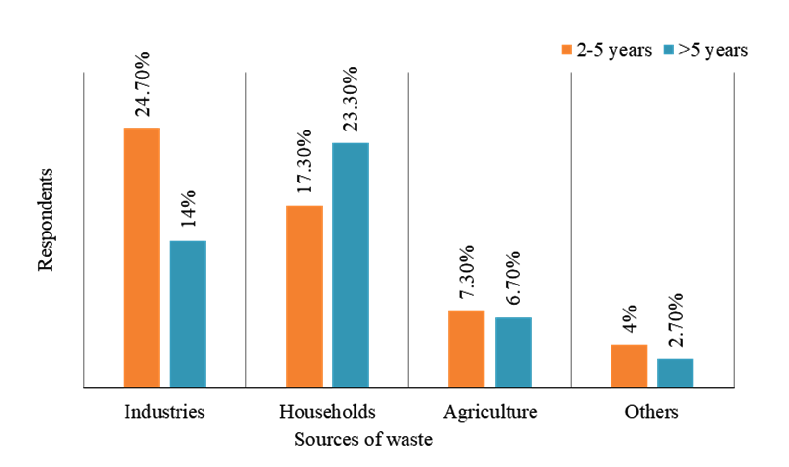
Considering the sources of pollution, figure 5 represents that, in most cases, the river has been subjected to excessive pollution in the last 2-5 years, and pollutants are coming into the river from different sources during this time. About 23.3% of household waste has been dumped in the river for more than 5 years. 24.7% of industrial waste is mixed into the stream from the last 2-5 years. Also, pesticides used in agricultural land significantly contribute (7.30%) to the reduction of water quality and flow in the previous 2-5 years.
Figure 5. Waste dumping sources and duration
4.11 Types of Contaminated Particles Pollutes the Ichamati River Water
For the last few decades, several factors contribute to the pollution of river water in Bangladesh. Waste materials produced from households or industries are the leading cause of river water pollution. Table 7 demonstrates that based on the community perception of the people who live beside the riverbank, the pollutants that go into the river are mainly of three categories. Among the categories, 47% is solid waste, 35% is liquid waste, and 18% is contaminated with other pollutants significantly contributes in the pollution of Ichamati River water.
Table 7. River water pollutants
Pollutant types
%
Solid waste
47
Liquid waste
35
Others
18
4.12 Recreational Demand
Recreation is an activity of leisure that is an integral part of human biology and psychology. Recreation activities are often done for pleasure, amusement, and are regarded as fun. Recreation is a time spent in an activity that one likes to engage in to feel refreshed (Kafy et al., 2018; Li and Qian, 2018; Freiman, 2019; Yan et al., 2019). Several surveys show that water activities are one of the most common recreational activities. Statistics also show that developed countries rely heavily on recreation-related to water activities. Recreation activities significantly increase around the Ichamati riverfront in the last few years (Loucks, 2000; Sipes, 2010; UNSDG, 2015; World Bank, 2016; Ojha et al., 2017; Kafy, 2018).
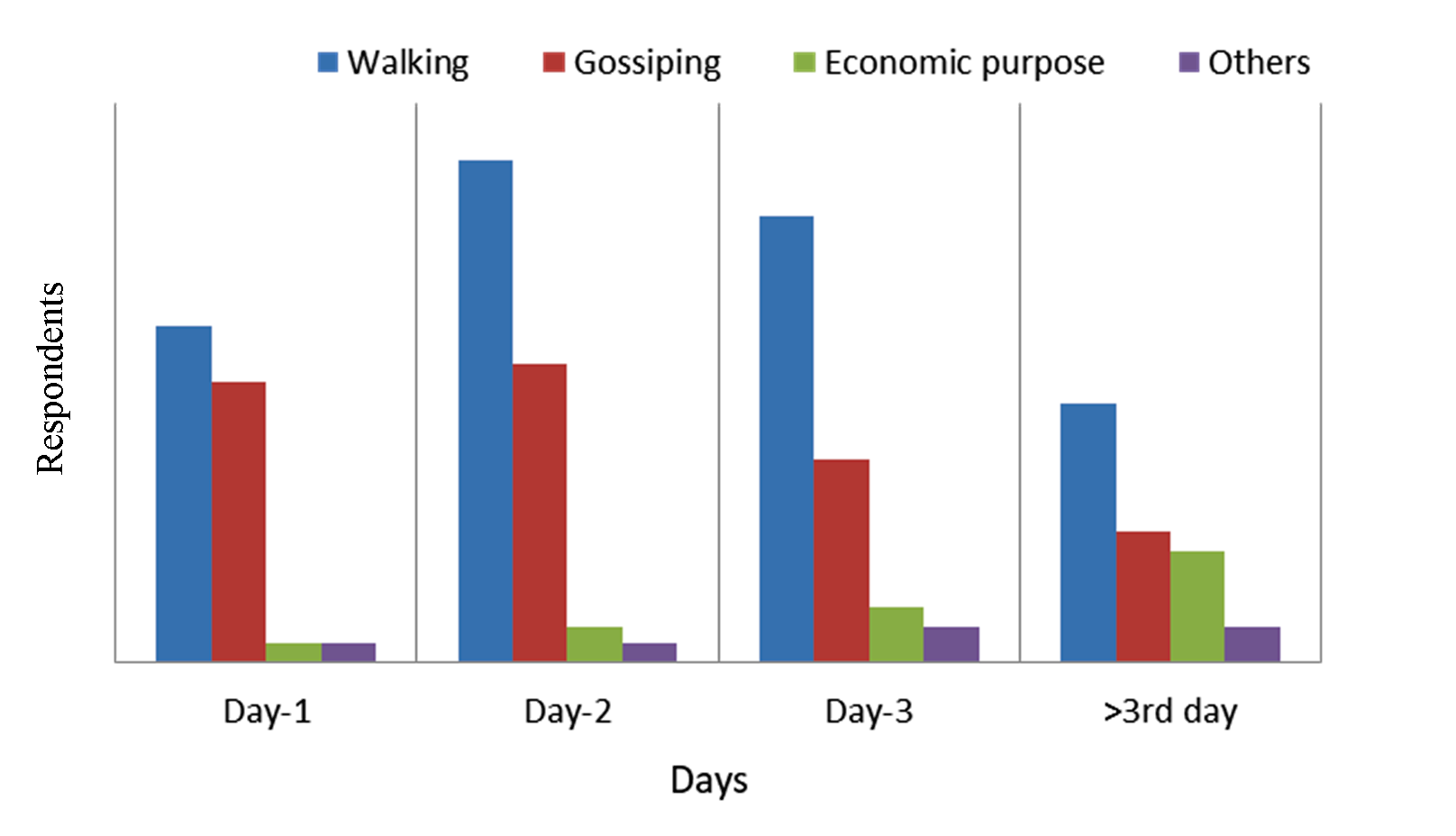
Ichamati River is used by people for different needs (Figure 6). Most people choose this river as the place of morning walk. About 18% of people visit the Ichamati River for walking purposes in two days a week. About 7.3% of people visit the river three days a week for gossiping purposes. And 4% of people travel on the river for more than three days for their economic purpose.
Figure 6. Day-wise visiting purpose in the Ichamati riverfront
At present, the Ichamati River has reached to the final stage of pollution. The intensity of pollution is so high that there is no other way to save the river without alternative use. The river can be taken to a new turn by creating an attractive recreation center on the banks of the river according to the needs of the local people. The demand of the local people for building a state-of-the-art recreation center on the banks of the Ichamati River is highlighted in table 8.
Table 8. Riverside recreational demand of the local people
Demand
%
Wading pools
12
Amusement rides water ride
29
Fishing piers and platforms
16
Recreational boating facilities
18
Play areas
25
It is clear that, as people are regularly traveling along the banks of the river and there are various recreational activities to be noticed, they have different recreational demands around the riverside. About 29% of the people want the amusement water ride along the Ichamati which will be completed by the state-of-the-art facility. About 25% of people want a place for sports on the river bank. About 18% of people want a recreational boating facility in the river by polluting the river. Simultaneously, if the pollution of river water will reduce, it will ensure the proper flow of water and help the fish to reappear. Based on the improvement, so 16% of the people have demanded fishing piers and platforms along the river.
5 . DESIGN PRINCIPLES OF THE RIVER-FRONT DEVELOPMENT
The design of a state-of-the-art entertainment center has been proposed to fulfill the entertainment needs of all people and ensuring river biodiversity and sustainability. Since there is a lack of proper regulated and well-designed recreation center in Pabna city, a recreation center with all kinds of modern facilities has been proposed here.
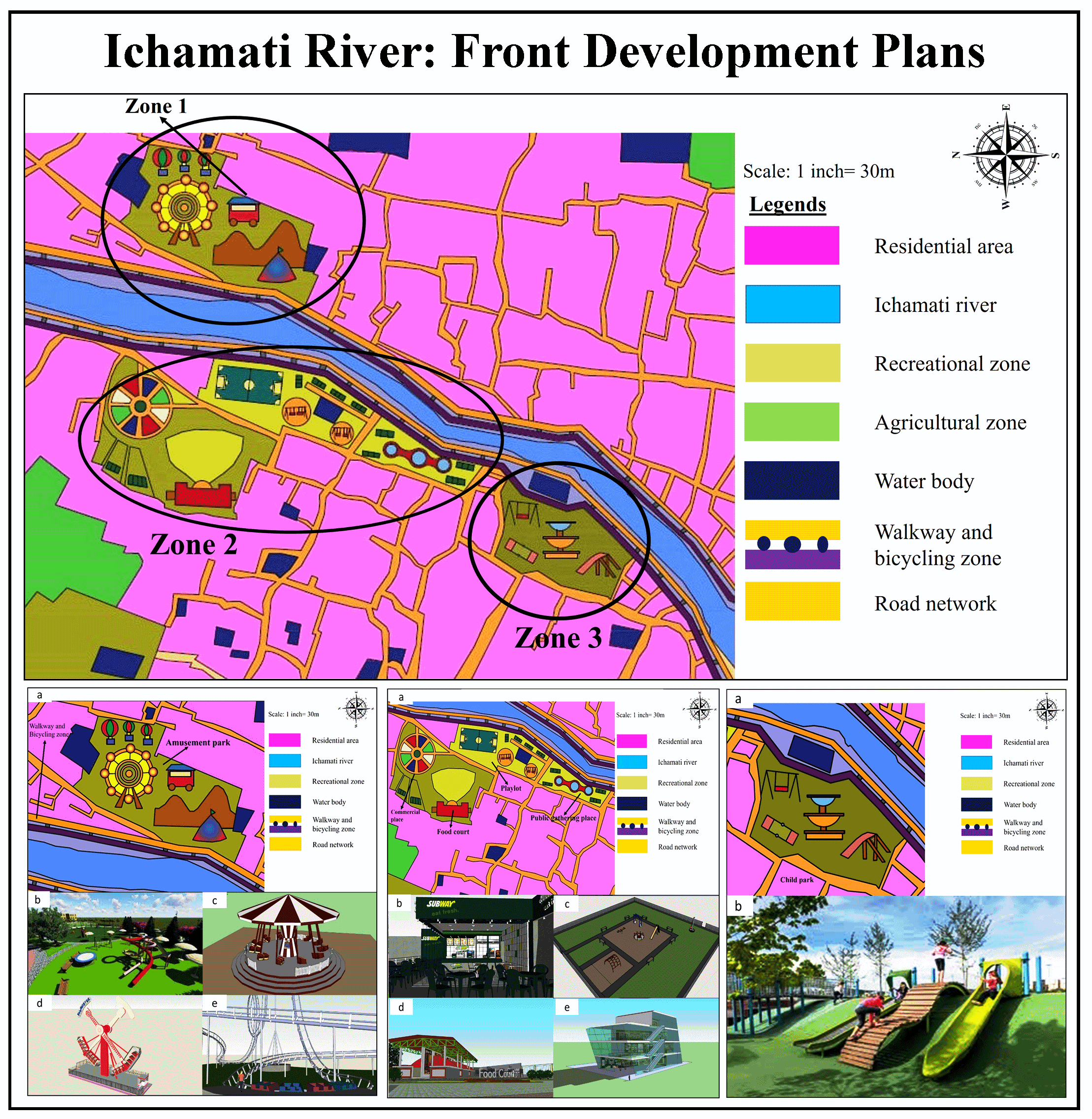
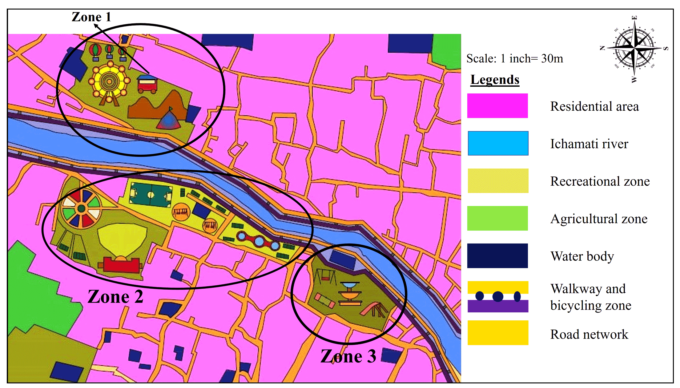
In this study, 30 km is the place (showed in figure 7a) has been considered as a study area. Several sites are vacant in the vicinity of the Ichamati River, which are currently being misused and used as a place for dumping the daily garbage collected from several parts of the city. Therefore, through proper reuse of all these vacant spaces, it can be easily used as a place for recreational site design. The area identified above figure 7b represents the vacant spaces in the bank of the river Ichamati. For maintaining better illustration and standard principles of the design, the proposed, designed area is divided into three zones. The recreational demand of local people has been given priority in every zone design (Figure 8).
Figure 7. Locations of the proposed design zones a) Study area and b) Proposed locations
Figure 8. The proposed zoning design map
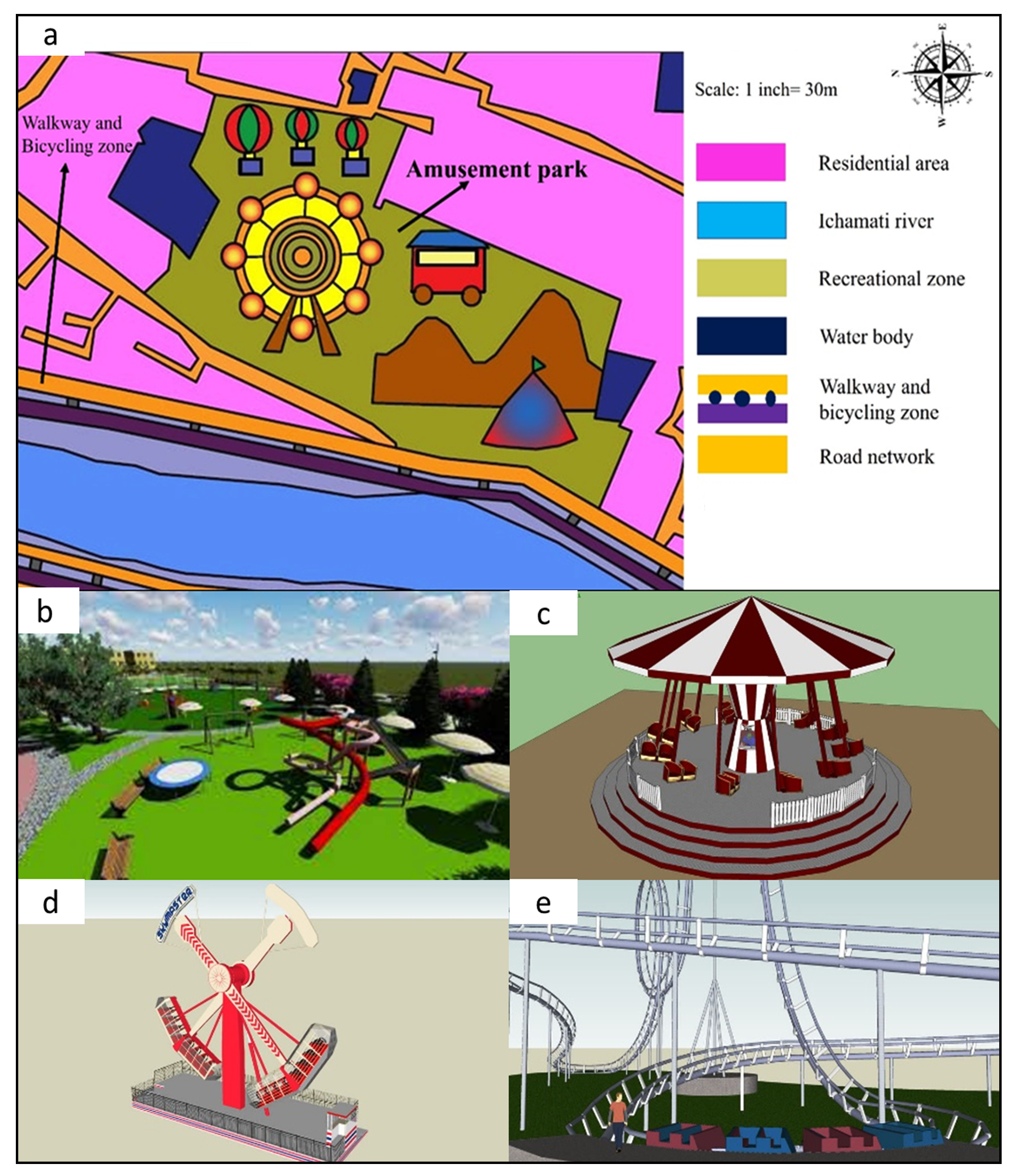
5.1 Zone-1: Amusement Park
The amusement park currently presents in Pabna city does not have enough facilities. There are only one or two rides that are not able to meet the entertainment needs of the people. Therefore, according to the recreational demand of the people of the city of Pabna, it is proposed to set up an amusement park in zone-1 (Figure 9a). This amusement park will have all kinds of recreational facilities, including modern rides such as Slipper ride (Figure 9b), Carousel (Figure 9c), Pendulum ride (Figure 9d), Roller coaster (Figure 9e), etc. This amusement park will be able to meet the recreational demands of the people of Pabna and build a permanent recreation center on the bank of the Ichamati River.
Figure 9. The proposed design of zone-1
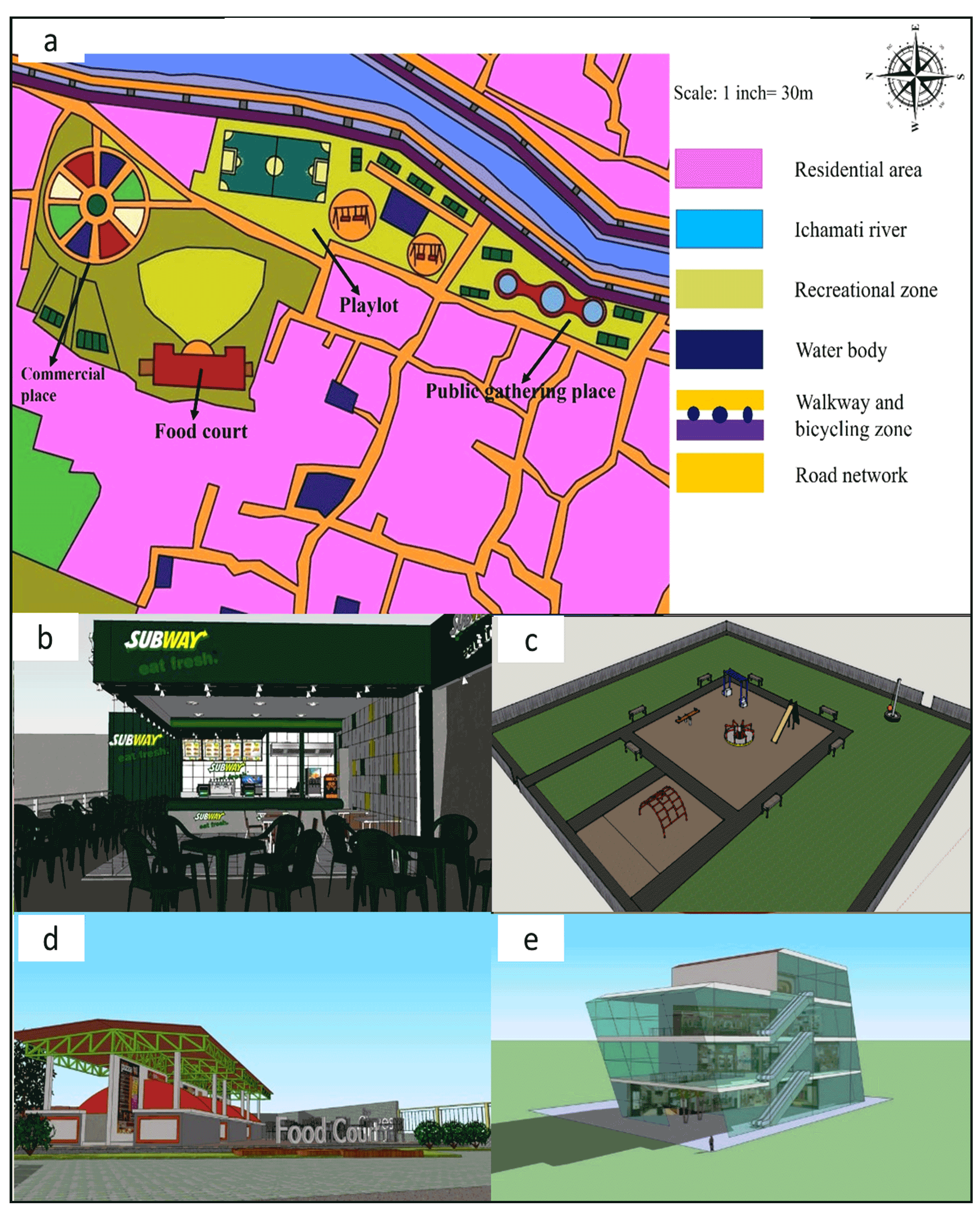
5.2 Zone-2: Public Gathering Spot
In terms of zone 2 design, it has been considered as a public gathering spot (Figure 10a). Various social gathering spots have been proposed to prevent river pollution in the vacant areas along the river. All of these proposals include a food court (Figure 10d), a playground (Figure 10c), a restaurant (Figure 10b), and a shopping mall (Figure 10e). Besides, several sitting benches have been proposed to enjoy the beautiful landscapes of the river. Proper implementation of these proposals will ensure people’s presence on the river bank and create the riverside as a recreational hub. The proposed zone-2 design will ensure the stoppage of unwanted garbage dumps and river water contamination, which will ensure river biodiversity.
Figure 10. The proposed design of zone-2
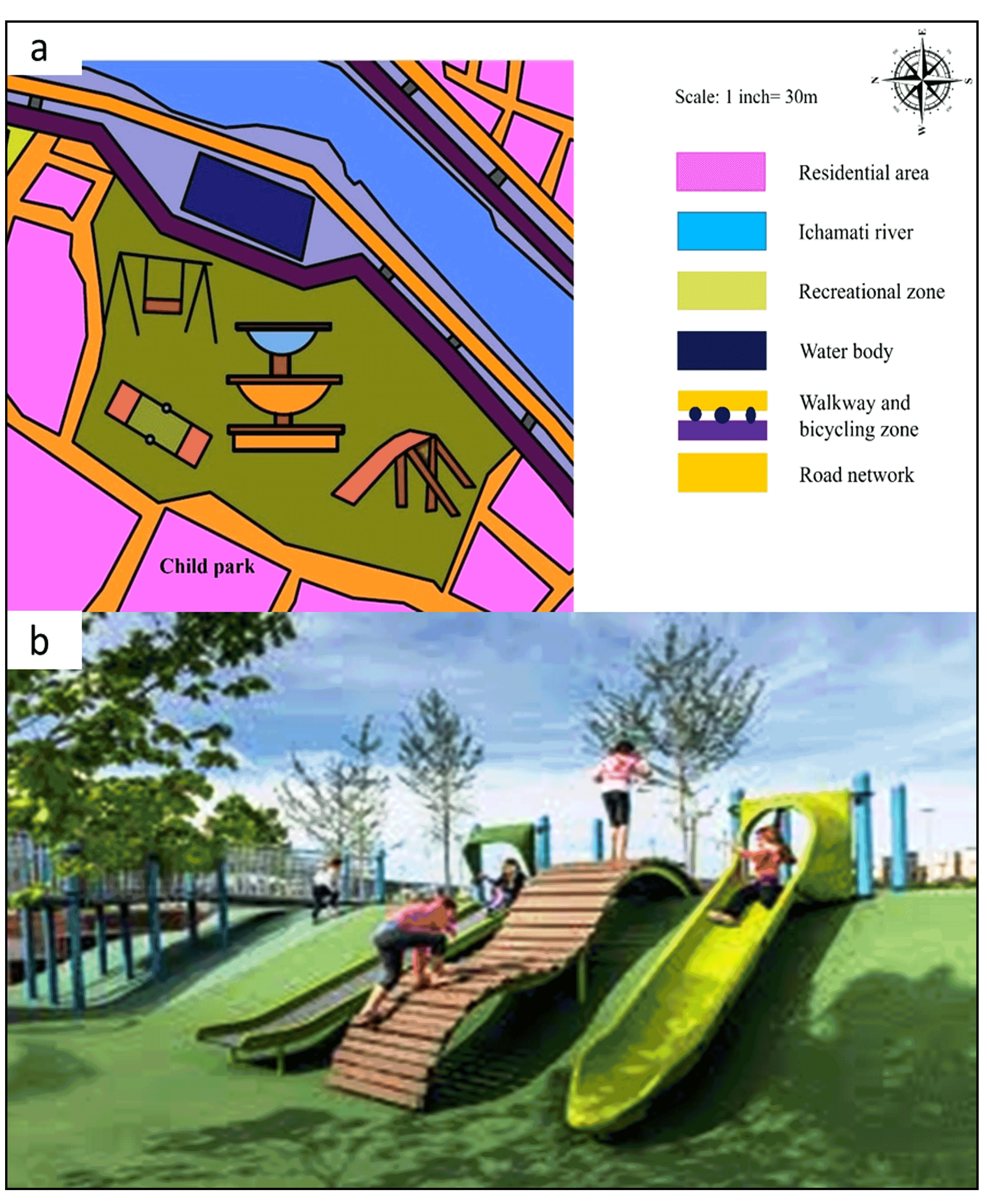
5.3 Zone-3: Children’s Play Lot
The proposed zone 3 design mainly focused on the purpose of children’s entertainment (Figure 11a). The design includes a small play lot (Figure 11b), where all types of children’s entertainment content have been proposed. This play lot on the river bank will ensure the regular presence of children in the proposed recreational zone.
Figure 11. The proposed design of zone-3
6 . POLICY MEASURES FOR THE RESTORATION
For ensuring sustainable conservation and restoration of Ichamati river several policy measures are mentioned in this section based on the suggestions of the local experts in a different field such as city officials, urban planning, policymakers, and environmental engineers.
6.1 National Goals and Water Policies
National Water Policy, 2010 is formulated by the Government of Bangladesh to govern the planning and development of water resources and their optimum utilization. The main objective of this policy is to solve public problems such as the supply of fresh drinking water and availability of water in the agricultural sector (Chowdhury, 2010). There are many shortcomings in implementing water policies because the political sector plays an influential role in Bangladesh. For more significant outcomes of water policies to restore river water and solve water-related problems, major changes are needed in various sectors, especially in local government institutions. Policies will be more successful when there is better cooperation between various ministries, agencies, alternatives.
6.2 River Basin Management Plans
Including river basin management plan in national water policy will make a significant impact on river restoration and pollution control. River basin management plans are designed to protect and improve water flow and quality (Sood and Mathukumalli, 2011). Such initiative contains water environment issues and the steps needed to address them in order to improve water in rivers, estuaries, coasts, aquifers, lakes, small water bodies and wetlands for the establishment of pleasant ecological environment in river biodiversity.
6.3 Inclusive Water Governance
Several additional policies overlap and connect with the present Water Act such as the Disaster Management Act 2009, Integrated Small-Scale Irrigation Policy 2011, Coastal Development Strategy 2006, the Coastal Zone Policy 2005, National Policy for Safe Water Supply and Sanitation 1998, Environment Conservation Act 1995, National Forest Policy 1994, Groundwater Management Ordinance 1985 and the Forest Act 1927. Lack of effective coordination between different institutions is identified as the major obstacle in the proper implementation of water governance. Water Resources Planning Organization (WARPO) is functioning under the Ministry of Water Resources as the lead organization of overall water sector Institutions. For inclusive water governance a variety of high-quality resources and capacities need to be incorporated such as sound scientific and technical knowledge and capacity; the availability of modern and appropriate technologies; sound institutional mandates; skilled workforce for effective execution; adequate funding and equitable financial allocation; adequate institutional infrastructure; and transparency and accountability.
7 . CONCLUSIONS
The river is a blessing and one of the essential natural resources for any country. Considering the overall situation of the district of Pabna, it is possible that the Ichamati River can easily associate with other economic activities, including agricultural productivity and inland transportation. According to the information obtained, most of the waste produced from several sources is dumped on the riverbank because of the absence of waste collection and removal system. Lack of sanitation facilities in low-income households also creates improper sewerage connectivity, which reduces the quality of the Ichamati river water. Improper connection of sewerage systems with the river creates a negative impact on fisheries production. The river is on the verge of death, and the water is unhygienic for the use of any indoor and outdoor activities. The root causes behind this issue are unplanned urbanization, illegal construction beside the riverbank, absence of water law, and lack of strict rules and regulations for controlling the degradation of natural resources. Besides this, unplanned industrialization and settlements, illegal dumping of industrial chemical and household waste in the river, and lack of awareness among people about the importance of river biodiversity significantly impacts the water pollution and river fill up. Significant initiatives need to be taken for the improvement of the water quality, restoring the dead parts of the river, and an effective design approach for using the Ichamati River bank as a recreational hub for the city. This study proposed effective policy measures and a design approach of a riverfront recreational hub development using local experts and community perception. As the visitors are the main components of a recreational hub, this design will surely fulfill the demand of visitors. The zoning techniques used in this study will satisfy the recreational need for different age people. The output of this study will be helpful for policymakers, government officials, urban planners, and engineers in inclusive riverfront development, which will reduce river pollution, ensure the dynamic flow of the river, and conservation of river biodiversity for ensuring environmental sustainability.
Tables
Figures
Conflict of Interest
The authors declare that they have no known competing financial interests or personal relationships that could have appeared to influence the work reported in this paper.
Acknowledgements
We would like to thank MD. Sohanur Rahman of Pabna Edward College, who assisted us in conducting the survey. Finally, we want to express our gratitude to the anonymous reviewers for their constructive comments for the improvement of the paper.
Ali, A., 2014. Economic Valuation of Rural Wetland in Bangladesh: A Case Study of Padma Beel (Jalarpar Beel) of Pabna. Reserach Proposal, submitted In partial fulfillment of the requirements for the degree of Master of Economics, University of Dhaka.
World Bank, 2016. Climate Change and Sustainable Report- Bangladesh. World Bank.
8.
Birdsall, N., Kelley, A. C., Sinding, S. W. and Sinding, S., 2001. Population matters: Demographic change, economic growth, and poverty in the developing world. Oxford University Press.
Brunn, S. D., 2003. Cities of the world: world regional urban development. Rowman and Littlefield.
11.
Brunn, S. D., 2003. Cities of the world: world regional urban development. Rowman and Littlefield.
12.
Chakma, M. and P. Chakrabartty., 2017. Water Logging and Drainage Planning in Bangladesh: A Case Study of Pabna Municipality, Pabna. International Conference on Planning, Architecture and Civil Engineering.
Kafy, A. A and Poly, S. A., 2018. Assessment of water supply system and water quality of Rajshahi WASA in Rajshahi City Corporation (RCC) area, Bangladesh. 1st National Conference on Water Resources Engineering (NCWRE 2018), CUET, Chittagong.
22.
Kafy, A. A and Poly, S. A., 2018. Assessment of water supply system and water quality of Rajshahi WASA in Rajshahi City Corporation (RCC) area, Bangladesh. 1st National Conference on Water Resources Engineering (NCWRE 2018), CUET, Chittagong.
Kafy, A. A., Ali, S., Ferdous, L. and Sheel, P. K., 2018b. Using contingent valuation method to determine economic value of Padma River wetland in Rajshahi District, Bangladesh. 1st National Conference on Water Resources Engineering (NCWRE 2018), Chittagong, Bangladesh.
Mondal, I. and J. Bandyopadhyay., 2014. Environmental change of trans international boundary Indo-Bangladesh Border of Sundarban Ichamati River catchment area using geoinformatics techniques, West Bengal, India. Universal Journal of Environmental Research and Technology, 4(3).
Mondal, M. and L. Satpati., 2015. Long profile analysis of Ichamati river with the help of best fit-curve, India. Indian J. of Geomor., 20(2), 109-124.
Pijanowski, B. C., Gage, S. H., Long, D. T. and Cooper, W. C., 2000. A land transformation model: Integrating policy, socioeconomics and environmental drivers using a geographic information system. Landscape Ecology: A Top Down Approach: 183-198.
Roy, K., Akter, S. and Islam, M., 2018. Assessment of Supplied Water Quality of Rajshahi Wasa (RWASA) in Bangladesh. Proceedings of the 4th International Conference on Civil Engineering for Sustainable Development (ICCESD 2018), KUET, Khulna, Bangladesh.
46.
Sami, M. M. I., Chowhan, T. and Sultana, F., 2000. River ecosystem restoration: In perspective to Turag River. Journal of Modern Science and Technology, 6(3) 34-46.
Siddiquee, S. A. and M. E. Hoque., 2007. Wetland conservation in context of climate induced changes: Bangladesh perspective. Journal of Economics and Sustainable Development, 2(3), 1-12.
49.
Sipes, J. L., 2010. Sustainable solutions for water resources: Policies, planning, design, and implementation, John Wiley and Sons.
50.
Solanes, M. and Gonzalez-Villarreal, F., 1999. The Dublin principles for water as reflected in a comparative assessment of institutional and legal arrangements for integrated water resources management, Global Water Partnership Stockholm.


 ,
Farhana Afroz 1
,
Farhana Afroz 1