Article Title :
Monitoring and Measuring the Urban Forms Using Spatial Metrics of Howrah City, India 

4 (2020)
19-39
Diversity Index , Growth Index , Remote Sensing , Urbanization


Monitoring and measurement of urban growth pattern with the help of urban-rural gradient and spatial metrics are gaining significant importance in recent times. Rapid and unplanned urban growth has a great impact on natural resources, local ecology, forestry and infrastructure. Temporal satellite data, gradient analysis and landscape metrics of urban landscapes will help to evolve appropriate strategies for integrated planning and sustainable management of natural resources. This communication focuses on spatiotemporal patterns of land use dynamics of Howrah Municipal Corporation (HMC), India and its surroundings with six buffer zones of 2kms. Analysis has been carried out on HMC using temporal remote sensing data. HMC has been used to identify the changes in the gradient of urban to peri-urban and rural regions. Further, the entire study area has been divided into eight zones radiated from city center based on directions. Different landscape metrics have been computed for each zone which helps to understand the spatiotemporal patterns and associated dynamics of the landscape at local levels.
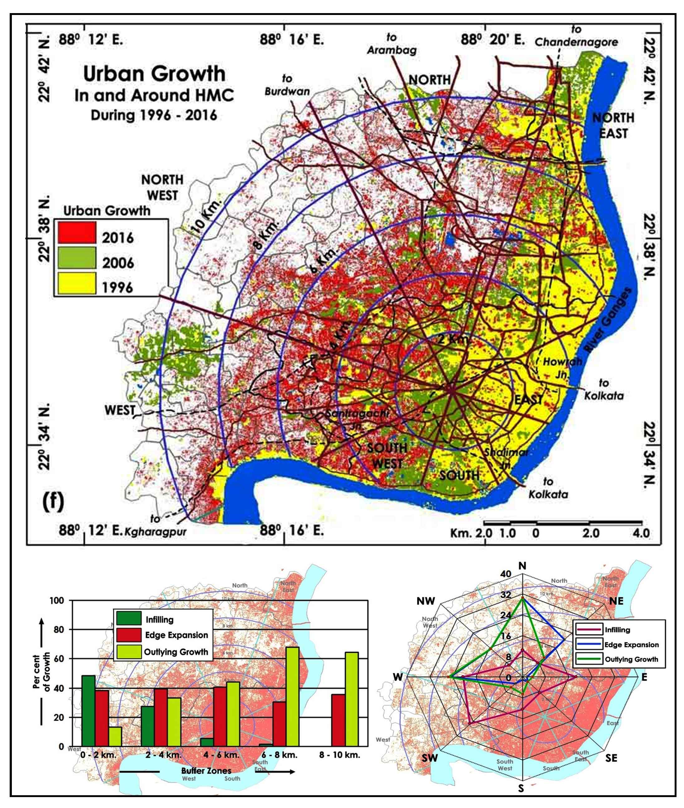
Extracted maps and multi-temporal satellite images have been examined and quantifying to study the form of urban growth in Howrah city, India.
Infilling, edge expansion and outlying growth types has been estimated through rural urban gradient and direction wise.
Urban spatial metrics has been quantifying along buffer and direction wise to study the fragmentation and compactness of urban growth.
Driven factors associated with urban growth are suggested for monitor the sustainability of urban growth.
Estoque, R. C., Murayama, Y., Kamusoko, C. and Yamashita, A., 2014. Geospatial analysis of urban landscape pattern in three major cities of Southeast Asia. Tsukuba Geoenviron. Sci., 10: 3-10.
Gutman, G., Janetos, A. C., Justice, C. O., Moran, E. F., Mustard, J. F., Rindfuss, R. R., Skole, D., Turner, B.L. and Cochrane, M. A., 2004. land change science: Observing, monitoring and understanding trajectories of change on the Earth’s Surface; Kluwer Academic: New York, NY, USA.
Ke, X., Qi, L. and Zeng, C,. 2015. A partitioned and asynchronous cellular automata model for urban growth simulation. International Journal of Geographical Information Science. 4, 637-659.
Kim, D. and Batty, M., 2011. Calibrating cellular automata models for simulating urban growth: Comparative analysis of SLEUTH and Metronmica: CASA Working Paper 176, UCL (University College of London).
Lea, C. and Curtis, A. C., 2010. Thematic accuracy assessment procedures: National park Service Vegetation Inventory, version 2.0. Natural Resource Report NPS/2010/NRR-2014/204, National Park Service, Fort Collins, Colorado, USA.
Li, Y. A. X., 2001. Measurement and monitoring of urban sprawl in a rapidly growing region using entropy. Photogrammetric Engineering and Remote Sensing, 67: 83-90
Mandelbrot, B. B., 1989. The Fractal Geometry of Nature, 1st Ed., Freeman: New York, NY.
Mcgarigal, K., Cushman, S. A. and Neel, M. C., 2002. FRAGSTATS: Spatial Pattern Analysis for Categorical Maps.
Ramachandra, T. V., Setturu, S., Bharath, H. and Aithal, T., 2012. Peri-urban to urban landscape patterns elucidation through spatial metrics. International Journal of Engineering Research and Development, (12), 58-81.
Weng, Q., 2008. Remote sensing of impervious surfaces: An overview. Remote Sensing of Impervious Surfaces; Taylor and Francis Group, Fl, USA.