

Article Title :
Morphometric and Sinuosity Analysis of Tlawng River Basin: A Geographic Information System Approach 
5 (2021)
22-32
Sinuosity , GIS , Channel planform , Bifurcation Ratio


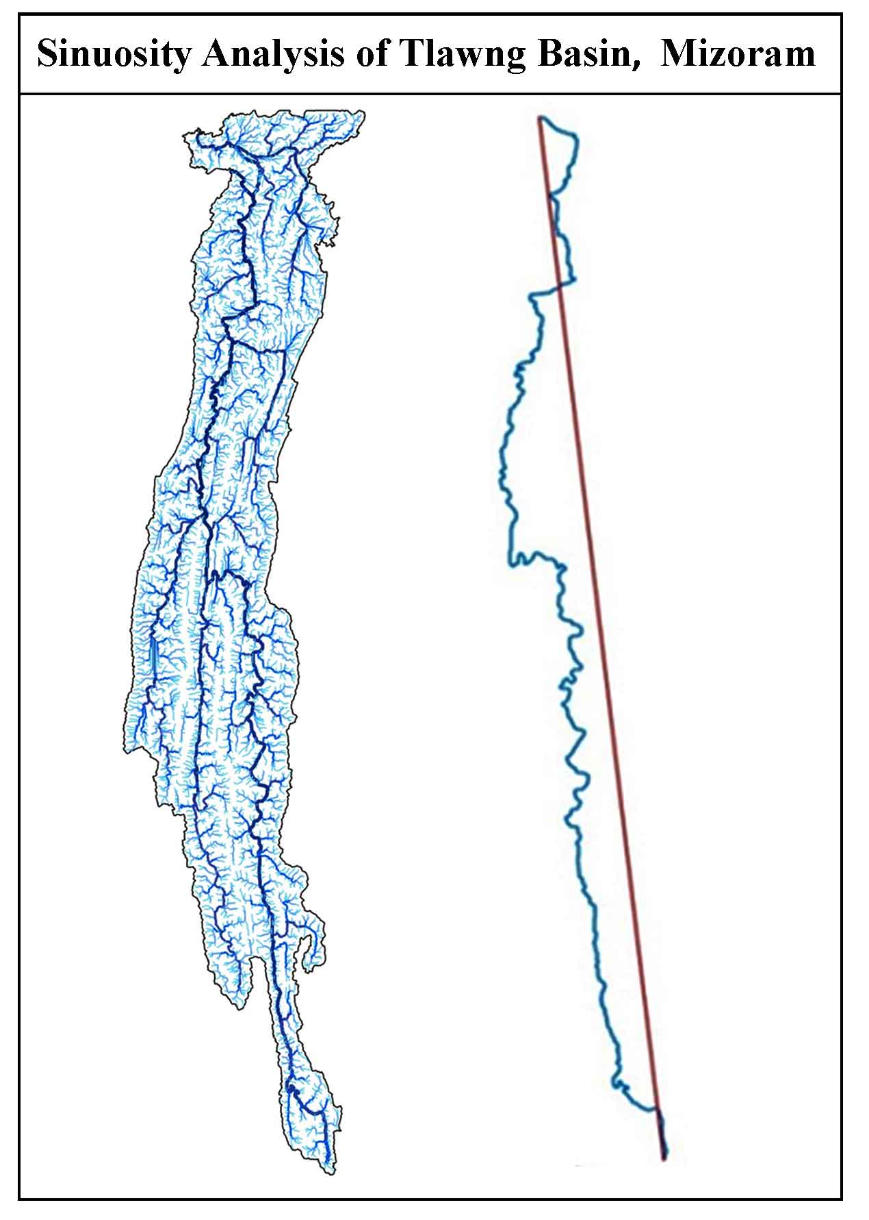
Channel plan-form patterns of river Tlawng has been studied which shows that there is variation in the sinuosity index. This variation is a sign of changing characteristics and behavior of the river. The average sinuosity of the river is 1.41. The sinuosity index is higher in the lower course of the river as it flows through alluvial plain. GIS techniques have been used for studying morphometric parameters. There are 6736 streams in the Tlawng river basin which shows that the topography is still undergoing erosion as the number of stream is high (Zaidi, 2011). The river has low bifurcation ratio which indicates less possibilities of flooding. The drainage density indicates the higher permeable subsoil and moderate to thick vegetative cover. The stream frequency value of the Tlawng river basin is 1.30 streams / km2 which shows a positive relation with drainage density.
This article is an attempt to quantitative study of the morphometric parameters of Tlawng river basin.
Sinousity index of different courses has been calculated to understand the planform characteristics of the river.
Morphometric analysis is useful for flood management, ground water assessment, soil erosion assessment and water resource management.
The topography is still undergoing erosion due to large stream number.
Brice, J. C., 1964. Channel pattern and terraces of the Loup River in Nebraska; US Government Printing Office: Washington, DC, USA, 1964.
Chow, V. T., 1964. Handbook of Applied Hydrology. McGraw-Hill Book Company, New York.
Clarke, J. I., 1966. Morphometry from maps, Essays in geomorphology, Elsevier Publ. Company, New York, 235-274.
Dingman, S. L., 2009. Fluvial Hydraulics. New York: Oxford University Press, 20-94.
Friedkin, J. F., 1945. A Laboratory Study of the Meandering Of Alluvial Rivers, U. S. Army Engineer Waterways Experiment Station, Vicksburg, Mississippi.
Fryirs, K. A. and Brierley, G. J., 2013. Geomorphic Analysis of River Systems: An Approach to Reading the Landscape, John Wiley & Sons, Ltd, The Atrium, Southern Gate, Chichester, West Sussex, PO19 8SQ, UK.
Keller, E.A. and Pinter, N., 2002. Active Tectonics, Earthquakes, Uplift and Landscape. Prentice Hall, New Jersey.
Morisawa, M. and K. M. Clayton 1985. Rivers: Form and process. London; New York : Longman.
Patton, P. C., 1988. Drainage basin morphometry and floods. In: Baker, V., Kochel, R. and Patton, P., Eds., Flood Geomorphology, Wiley, New York, 51-65.
Strahler, A. N., 1964. Quantitative geomorphology of drainage basins and channel networks. In: VT Chow (ed.), Handbook of applied hydrology. McGraw Hill, New York, 4.39-4.76.

