Article Title :
Detection and Delineation of Water Bodies in Hilly Region using CartoDEM SRTM and ASTER GDEM Data 

1 (2017)
41-52
GIS , Elevation point feature , Digital Elevation Model , Water bodies , Flattered Surface Logic


Detection and delineation of Water Body Area (WBA), particularly over inaccessible hilly region is not always possible in view of time, resources and cost issues. An automated procedure for detection and delineation of water bodies in the hilly region was performed using satellite-derived DEMs. CartoDEM, SRTM and ASTER GDEM data with 30, 90 and 30 m resolutions, respectively to generate the Elevation Points Features (EPF) in GIS platform. Total 7194906 EPFs were generated using these three DEMs. Contour and slope maps were also prepared to eliminate the outlier EPFs (non-water bodies) with flattered surface logic. Flattened area on DEMs, connected contour at edges of water bodies and 0° to 0.5° slopping area were considered as WBA in the region (2311 Km2) of Western Ghat (India). The nearest neighbor to cubic convolution conversion of DEMs was found useful for detection of boundary of water bodies more precisely. These results were validated from Landsat-8 satellite images and topographic maps (Survey of India). About 3.09% from CartoDEM, 2.22% area from ASTER GDEM and 4.38% from SRTM DEM were estimated as WBA. CartoDEM data can be suggested for precise detection of smaller water bodies in hilly region. Methodology formulated in this study could be used as a rapid assessment tool for detection of water bodies, especially in the inaccessible region for better water resources management.
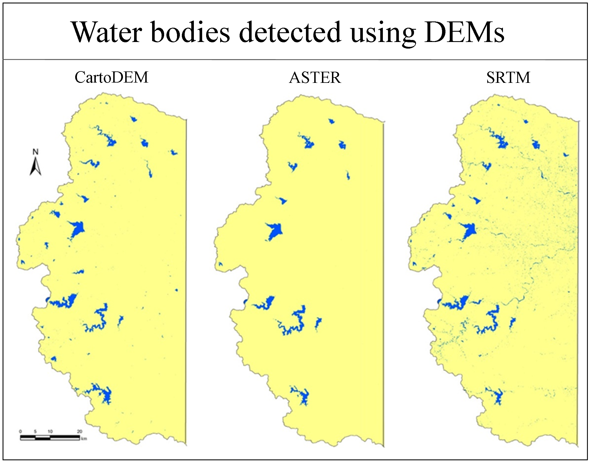
Detection of Water Body Area (WBA), especially in inaccessible hilly region is not always possible.
Automated procedure was used for detection of WBA in hilly region using DEMs data.
Elevation Point Features were generated using 3 DEMs in GIS software.
Flattered Surface Logic was used for detection of water bodies.
Flattened area on DEMs, contour connected to edges of water bodies and 0° to 0.5° slope were used for detection of WBA.
CartoDEM found more suitable for precise detection of WBA.
Burrough, P. A. and McDonnell, R. A., 1998. Principles of Geographic Information Systems, 333, New York: Oxford University Press.
Fu, J., Wang, J. and Li, J., 2007. Study on the Automatic Extraction of Water Body from TM Image Using Decision Tree Algorithm. Proceedings of the International Symposium on Photoelectronic Detection and Imaging: Technology and Applications 2007: Related Technologies and Applications, Beijing, 9-12.
Lidong, D. and Hao, W., 2006. Study of the water body extracting from MODIS images based on spectrumphotometric method, Geomatics and Spatial Information Technology, 29, 25-27.
Salmon, B. P., Kleynhans, W., Van Den Bergh, F., Olivier, J. C., Grobler, T. L. and Wessels, K. J., 2013. Land cover change detection using the internal covariance matrix of the extended Kalman filter over multiple spectral bands. IEEE Journal Sel. Topics Application Earth Observations Remote Sensing, 6, 1079-1085.