Article Title :
Detection and Delineation of Agricultural Land Losses in Minna, Niger State, Nigeria 
BASHIR ISHAKU YAKUBU
 ,
Sallau Rachel Osesienemo
,
HADIZA ALIYU
,
ABUBAKAR SHEIKH DANJUMA
,
Aminu Zunni
,
ABDULKADIR MUHAMMED
,
SOLOMON NDACE JIYA
,
Sallau Rachel Osesienemo
,
HADIZA ALIYU
,
ABUBAKAR SHEIKH DANJUMA
,
Aminu Zunni
,
ABDULKADIR MUHAMMED
,
SOLOMON NDACE JIYA
6 (2022)
28-39
Remote Sensing , Landsat , LULC , Geospatial analysis , Agricultural Land Loss , Agriculture


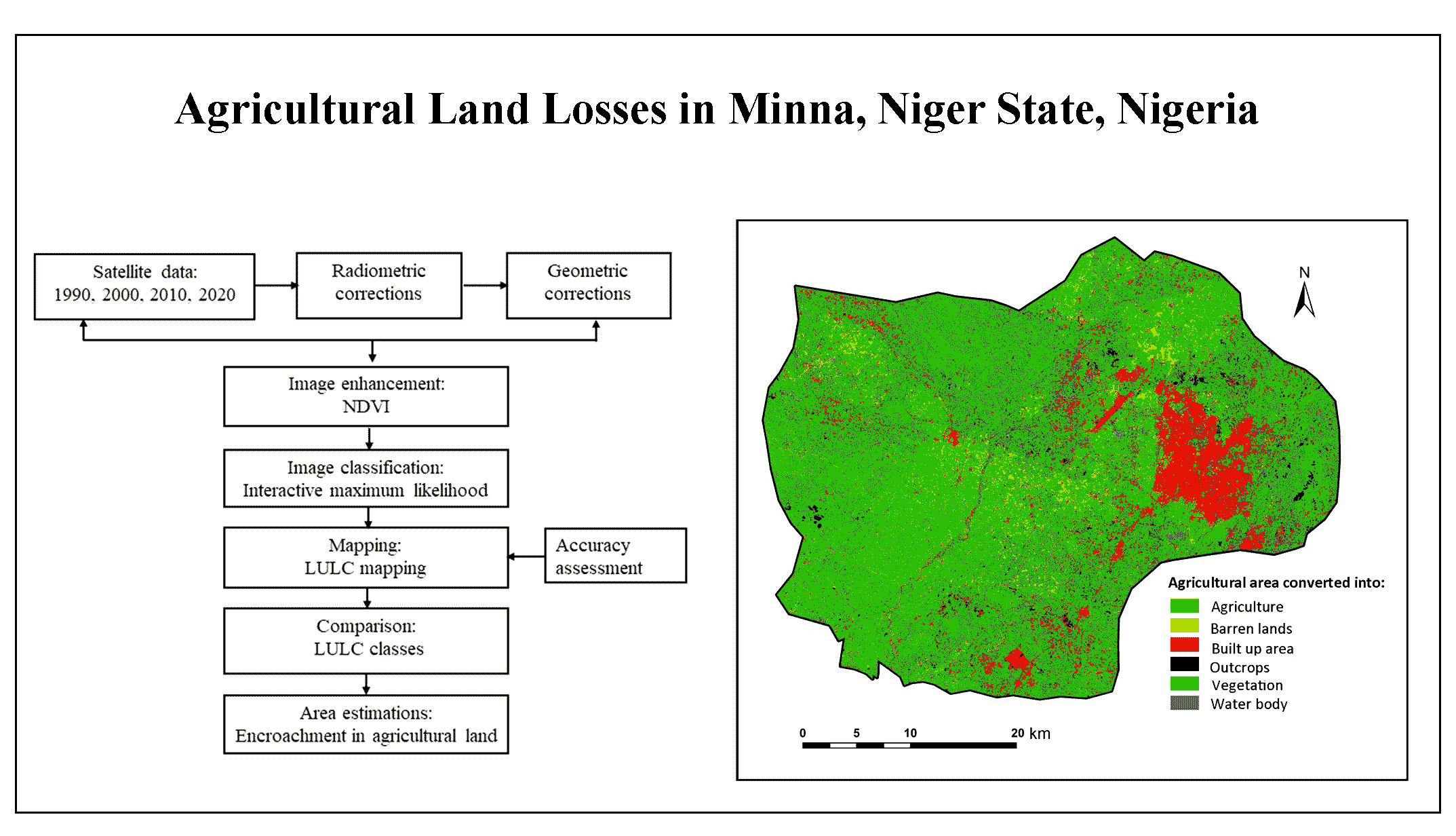
This study assessed the losses in agricultural lands and enrichment of other land usages in agricultural area in Minna and environs in the state capital of Niger state, Nigeria. Data captured using Landsat Multispectral Scanner (MSS) (1990), Thematic Mapper (TM) (2000-2010) and Enhanced Thematic Mapper plus (ETM+) (2000, 2010 and 2020) used to quantify LULC changes. A post-classification matrix prepared to assess the modification and conversion in LULC from 1990 to 2020. The significant modification in LULC observed as agricultural lands and vegetation underwent noticeable decline by 714.39km2 and 578.94km2, respectively whereas built up area increased substantially to a value of 96.91km2. About 12.29km2 agricultural land lost to barren land and 12.83km2 converted to water bodies. Finally, the encroachments of vegetation and built up area in agricultural area caused substantial decreased the available land for agricultural activities. Remote sensing data provide useful for estimations of agricultural land loss on a regional scale.
Remote sensing provides a robust database for assessment of historical changes in LULC conditions.
About 12.29km2 agricultural land in the study area converted into barren land and 12.83km2 converted to water bodies.
The significant modification in LULC observed as agricultural lands and vegetation underwent noticeable decline by 714.39km2 and 578.94km2, respectively.
Remote sensing data is useful for estimations of agricultural land loss on a regional scale.
Abd, H. A. R. and Alnajjar, H. A., 2013. Maximum likelihood for land-use/land-cover mapping and change detection using landsat satellite images: a case study “South Of Johor”. International Journal of Computational Engineering Research, 3(6), 26-33.
Al-Tahir, R. and Ali, A., 2004. Assessing land cover changes in the coastal zone using aerial photography. Surveying and Land Information Science, 64(2), 107-112.
Bashir, Y. I., Muhammad, H. K., Hassan, S. M., Sallau, R. O., and Suleiman, H., 2019. Sustainable Urbanization in Minna, Niger State Nigeria using Geospatial Technique and Remote Sensing Data. Paper presented at the 1st Faculty of Natural Scences Annual Conference (FONSAC 2019), Ibrahim Badamasi Babangida University, Lapai, Niger State, Nigeria.
Brilliant, M. I., Suhendro, Y., Karnila, S. and Aziz, R. Z. A., 2020. Land Cover Changes Detection Using Region Growing Segmentation. Paper presented at the Journal of Physics: Conference Series.
Coulter, L. and Stow, D., 2005. Detailed change detection using high spatial resolution frame center matched aerial photography. Paper presented at the Proceedings of the 20th Biennial Workshop on Aerial Photography, Videography, and High Resolution Digital Imagery for Resource Assessment.
Famoriyo, S., 2010. Land tenure, land use and land acquisition in Nigeria. Institute for Agricultural Rsearch, Ahamadu Bellow University Zaria, Nigeria.
Gagniuc, P. A., 2017. Markov chains: From theory to implementation and experimentation, John Wiley and Sons.
Gigandet, X., Cuadra, M. B., Pointet, A., Cammoun, L., Caloz, R. and Thiran, J-P., 2005. Region-based satellite image classification: method and validation. Paper presented at the IEEE International Conference on Image Processing 2005.
Halim, M. K. A., Ahmad, A., Rahman, M. Z. A., Amin, Z. M., Khanan, M. F. A., Musliman, I. A., Kadir, W. H. W., Jamal, M. H., Maimunah, D. S., and Wahab, A. K. A., 2018. Land use/land cover mapping for conservation of UNESCO Global Geopark using object and pixel-based approaches. Paper presented at the IOP Conference Series: Earth and Environmental Science.
Hardin, P., J., Jackson, M., W. and Otterstrom, S. M., 2007. Mapping, measuring, and modeling urban growth Geo-spatial technologies in urban environments, 141-176, Springer.
Loveland, T. R., Sohl, T. L., Stehman, S.V., Gallant, A. L., Sayler, K. L. and Napton, D. E., 2002. A strategy for estimating the rates of recent United States land-cover changes. Photogrammetric Engineering & Remote Sensing, 68(10), 1091-1099.
Richards, J. A., 2013. Supervised classification techniques Remote sensing digital image analysis, 247-318, Springer.
Sharma, V., Diba, A., Neven, D., Brown, M. S, Van Gool, L. and Stiefelhagen, R., 2018. Classification-driven dynamic image enhancement. Paper presented at the Proceedings of the IEEE Conference on Computer Vision and Pattern Recognition.