

Article Title :
Climate Change Impacts on LULC in the Jarmet Wetland and its Surrounding Areas in Western Ethiopia 

7 (2023)
1-18
Climate , degradation , Landsat , LST , Maximum Likelihood Classifier


The concerns over land use and land cover (LULC) change have emerged on the global stage due to realization that changes occurring on the land surface also influence climate, ecosystem and its services. This study aimed to map the temporal dynamic of LULC patterns and LST in the Jarmet wetland in Ethiopia. The dynamics and pattern of changes for a period of 21 years (2000-2021) were analyzed using geospatial techniques. Multi-temporal satellite images from Landsat ETM+ and Landsat-8 OLI sensor data were used to extract land-cover maps. The Land Surface Temperature (LST) trend of the study areas was computed using MODIS satellite imagery (2000-2021). Supervised classification using a Maximum Likelihood Classifier (MLC) was applied to prepare LULC maps of the watershed. The accuracy of the classified map was assessed using high-resolution data, and ground realities have been verified and ascertained through field observations. The results revealed a decreased trend in wetland, forest, shrubland and grassland in the period of 21 years (2000-2021) by -1148.71ha, -1073.26 ha, -1480.1 ha, and -87.73 ha, respectively. On the other hand, farmland and plantation areas followed an increasing trend. LST revealed decreasing trend in terms of mean and minimum with a fraction change of -0.018 and -0.073, whereas the maximum LST value shows an increasing trend with 0.021. The overall accuracy was 84.41%, with Kappa index of 76.13%. The analysis and findings of the study highlight important policy implications for sustainable LULC management in the study area. The study suggests the design and implementation of a guided natural resource policy, stopping the illegal expansion of farmland and educating society about the value of the sustainable management of habitat reserves.
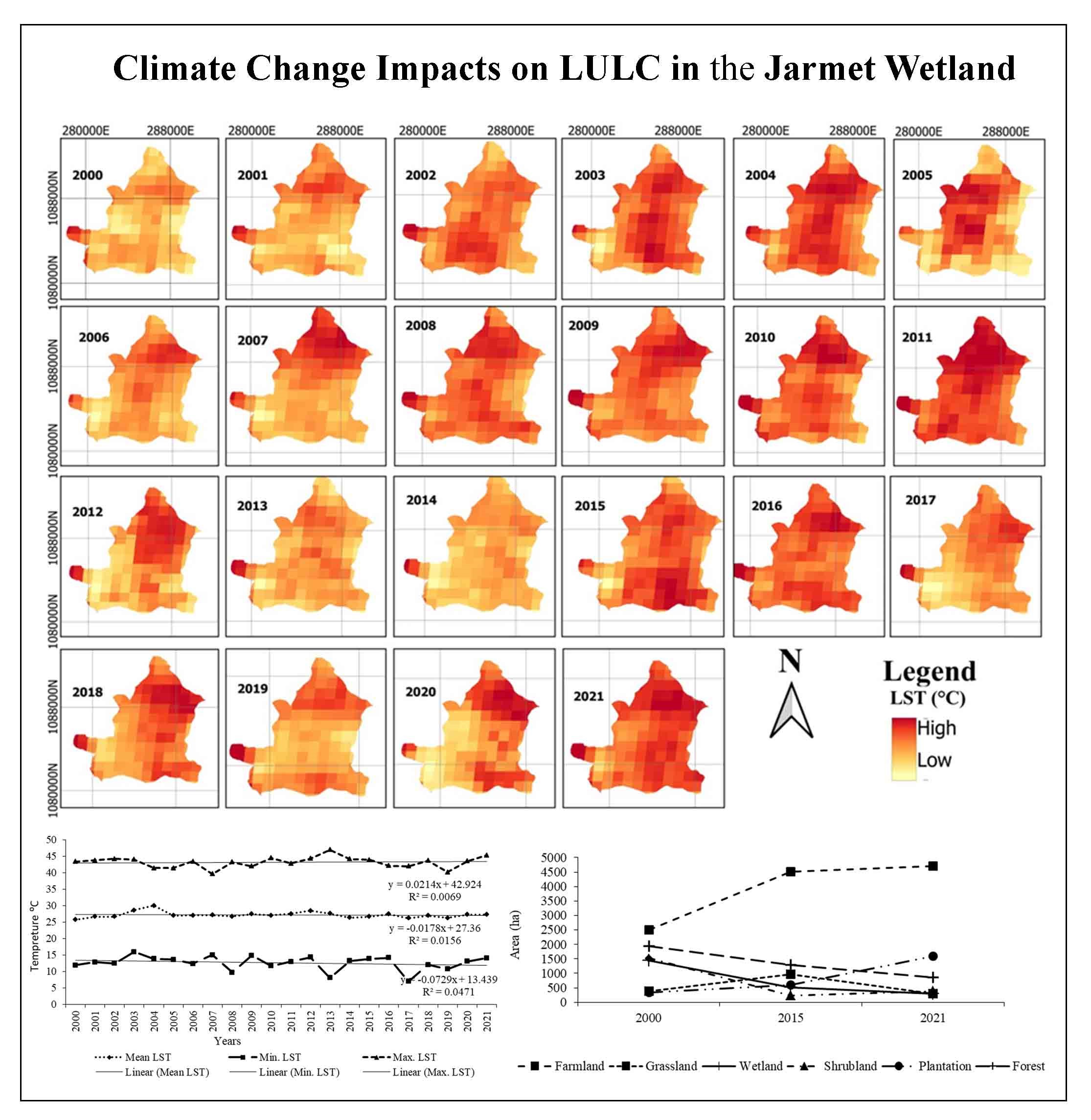
Spatial distribution of dominant land-use types in the study area.
Annual and seasonal trends of LST were computed.
Spatial trends were also highlighted.
Diurnal LST range trends were also evaluated on an annual basis.
Ayele, K. F., Suryabhagavan, K. V., and Sathishkumar, B., 2014. Assessment of Habitat Changes in Holeta Watershed, Central Oromiya, Ethiopia. International Journal of Earth Sciences and Engineering. 7, 1370-1375.
Congalton, R. and Green, K., 2009. Assessing the Accuracy of Remotely Sensed Data. Principles and Practices. 2nd Edition. CRC/Taylor and Francis, Boca Raton, FL 183.
Dugan, P., 1993. Wetlands in Danger. Oxford University Press. New York, NY, USA.
EPA [Environmental Protection Authority] 2004. Proceeding of the national workshop on the Ramsar Convention and Ethiopia. Addis Ababa,130.
FAO [Food and Agriculture Organization] 2003. Livestock’s long shadow. 00153 Rome, Italy.
Finlayson, M., and Moser. M., 1991. Wetlands. International Waterfowl and Wetlands Research Bureau. Facts on File Ltd. Oxford, UK, 224.
Foody, G.M., 2002. Status of land cover classification accuracy assessment. Remote Sens Environ, 80,185-201.
Jensen, J. R., 2005. Introductory Digital Image Processing, A Remote Sensing Perspective 3rd Edition. Prentice Hall, Upper Saddle River, NJ, USA.
Jensen, J. R., 2007. Remote Sensing of the Environment: An Earth Resource Perspec-tive, Upper Saddle River, NJ: Pearson Prentice-Hall, 592.
Lambin, E. F., and Geist, H., 2006. Land-Use and Land-cover Change on Local Processes and Global Impacts. Springer Verlag Berlin Heidelberg. Printed in Germany, 236.
Lellisand, M. T., Kiefer, R. W., and Chipman, J. W., 2004. Remote Sensing and Image Interpretation, Singapore. John Wiley and Sons, Pvt. Ltd.
Lesschen, J. P., Verburg, P. H., and Staal, S. J., 2005. Land-Use and Land-Cover Change (LUCC) Project. IV. International Human Dimensions Programme on Global Environmental Change (IHDP) V. International Geosphere Biosphere Programme (IGBP). International Livestock Research Institute, Kenya.
Lillesand, T., Kiefer, RW., and Chipman, J., 2015. Remote sensing and image interpretation. Wiley, New York.
Melekneh, G., Suryabhagavan, K.V., and Balakrishnan, M., 2010. Land-use and landscape pattern changes in Holeta-Berga Watershed, Ethiopia. International Journal of Ecology and Environmental Sciences. 36, 117-132.
Misrak, A., Suryabhagavan, K. V., and Balakrishnan, M., 2012. Assessment of Cover Change in the Harenna Habitats in Bale Mountains, Ethiopia, Using GIS and Remote Sensing, International Journal of Ecology and Environmental Sciences. 38, 39-45.
Olson, J.M., Misana, S., Campbell, D.J., Mbonile, M., and Mugisha, S., 2004. The spatial pattern and root causes of land use changes in East Africa. LUCID Project Working Paper 47, International Livestock Research Institute, Nairobi.
RCW [Ramsar Convention on Wetlands] 2018. Ramsar Convention on Wetlands, Global Wetland Outlook: State of the World’s Wetlands and Their Services to People. Ramsar Convention Secretariat, Gland, Switzerland.
Sabins, F. F., 1997. Remote Sensing, Principals and Interpretation. New York: W.H. Freeman and Company. 494.
Wang, T. L., Zhou, L. F., and Yang, P. Q., 2008. Study of Panjin wetlands along Bohai Coast. The information System of wetlands based on 3S technique. Journal of Ocean University of China (English Edition),7(4), 411-415.
Warkaye, S., Suryabhagavan, K. V. and Satishkumar, B., 2018. Urban green areas to mitigate urban Heat Island effect: The case of Addis Ababa, Ethiopia. Int. J. Ecol. Environ. Sci., 44, 353-367.
WBISPP [Woody Biomass Inventory and Strategic Planning Project] 2005. A National Strategic Plan for the Biomass Energy Sector. Ethiopia: Federal Ministry of Agriculture. Addis Ababa.
WCED [World Commission of Environment and Development], 1987. Our Common Future. WCED. Oxford University Press. New York, USA, 398.


