

Article Title :
Assessing Land Use Change and Its Impact on Ecosystem Services in Khulna Conurbation 
7 (2023)
21-31
Valuation , Land use , Khulna , GIS , Ecosystem services


In this research, the land-use change of Khulna Conurbation has been dissected utilizing Landsat images from 1987 to 2018 through GIS analysis and its effect on the ecosystem has been decided with the assistance of auxiliary information. The study showed that in Khulna Conurbation, built-up territory expanded from 1343 ha to 4332 ha (223%) from 1987 to 2018. On the contrary, vegetation, water bodies, and river area decreased during that period. The ecosystem service values for all land use categories were negative except for urban built-up. The largest amount of decline was observed in the vegetation area (US $ 11.79 million) followed by rivers and water bodies. The built-up is the major contributor to ecosystem services in this area and has largely affected the ecosystem. Proper district and Upazilla level land use plans should be implemented to maintain the sustainable growth of the city and enhancement natural ecosystem services.
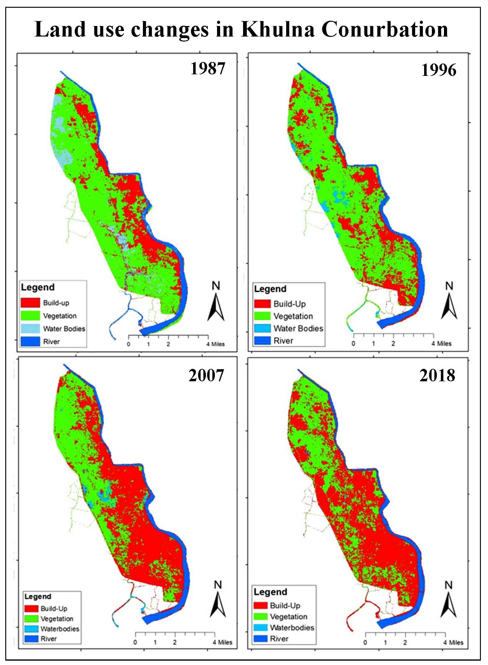
The build-up area increased at the expense of vegetation land, water bodies, and rivers.
Overall 37% of vegetation area was removed within 31 years.
The built-up area increased by 223% from 1987 to 2018 due to rapid.
Water bodies were decreased by 82% from 1987 to 2018 because of encroachment, urban development and waste disposal.
The river area also decreased during the period 1987 to 2018 from 784 ha to 692 ha (11.7%).
Ecosystem service value reduced of some of the land uses as vegetation, water bodies and river.
Ahmed, B., 2011. Modelling spatio-temporal urban land cover growth dynamics using remote sensing and GIS techniques: A case study of Khulna City. J. Bangladesh Instit. Plan, 4, 43.
BBS [Bangladesh Bureau of Statistics] 2022. Statistical Year Book of Population and Housing Census.
Mondal, K. K., Akhter, M. A., Mallik, M. and Hassan, S. Q., 2017. Study on rainfall and temperature trend of Khulna division in Bangladesh. Dew-Drop, 4, 77-83.
Rahman, M. M., Akteruzzaman, A. K. M., Khan, M. M. H., Jobber, A. and Rahman, M. M., 2009. Analysis of water logging problem and its environmental effects using GIS approaches in Khulna City of Bangladesh. Journal of Socioeconomic Research and Development, 6(2), 572-577.
Zannat, E.U., 2012. A Study on Land Use Policies of Khulna Structure Plan 2000-2020 in the Light of Climate Change Induced Flood Scenario. MURP (Urban and Regional Planning) Thesis, Department of Urban and Regional Planning, Bangladesh University of Engineering and Technology (BUET).
