Article Title :
Bathymetry Mapping using Landsat ETM+ Data and Field Measurements for West Coast of Yemen 
3 (2019)
28-38
Yemen , Red Sea , ETM+ , Landsat , Navigation , Bathymetry


The bathymetry of coastal waters in the Red Sea coastal water is of the vital importance for shipping safety because of presence of navigational hazards. We used remote sensing data from Landsat-7 (ETM+) for bathymetric mapping in Al-Luhaia port, Western Yemen. We used a global positioning system to locate the accurate sampling points for sea depth. An echo sounder was used to collect sea depth information. We examined suitability of wavelength bands for bathymetry. This paper puts forward a method to extract water depth information from multispectral data Landsat-7 (ETM+). We applied simple linear regression to relate field measured water depths to pixel brightness values in the blue band of Landsat-7 (ETM+) multispectral imagery that had been corrected to at-satellite reflectance using published calibration coefficients. The regression relationship at the clear shallow water site was accurate (R2 = 94.40% band 1) for water depths in the range 2 to 9m. The regression analysis offered by the model has been verified using data from 1500 points (depths) that were not used in model generation, were used for testing the validity. This validation test model offered a very good correlation coefficient, 0.9385. We made a comparison between actual depth measured by hydrographic echo sounder during the field measurement and the estimated depth derived from satellite images to establish the margins of error in the estimates. A mean of error of 4.08%, with an accuracy of 95.92% was found.
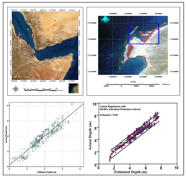
Landsat ETM+ data was used for bathymetric mapping in Al-Luhaia port.
An echo sounder was used to collect the data about sea depth.
Linear regression model used to correlate the measured and estimated depth values.
Validation test model offered a very good correlation coefficient, 0.9385.
Benveniste, J., Cazenave, A., Vignudelli, A., Fenoglio-Marc, L., Shah, R., Almar, R., Andersen, O., Birol, F., Bonnefond, P., Bouffard, J., Calafat, F., Cardellach, E., Cipollini, P., Cozannet, G. L., Dufau, c., Fernandes, M. J., Frappart, F., Garrison, J., Gommenginger, C., Han., G., Høyer, J. L.,Kourafalou, V., Leuliette, E., Li, Z., Loisel, H., Madsen, K. S., Marcos, M., Melet, A., Meyssignac, B., Pascua, A., Passaro, M., Ribó, S., Scharroo, R., Song, Y. T., Speich, S., Wilkin, J., Woodworth, P., and Wöppelmann, G., 2019. Requirements for a coastal hazards observing system. Front. Mar. Sci. 6, 348.
Danaher, T. and P. Smith, 1988. Applications of shallow water mapping using passive remote sensing. Proceedings of a Symposium on Remote Sensing of the Coastal Zone, Gold Coast, Queensland, 7 - 9 September 1988, 7.
Diaz, H., Almar, R., Bergsma, E. W. J., Leger, F., 2019. On the use of satellite-based digital elevation models to determine coastal topography. In Proceedings of the IGARSS 2019, IEEE International Geoscience and Remote Sensing Symposium, Yokohama, Japan, 28 July-2 August 2019.
Hesselmans, G., Calkoen, C. and Wensink, H., 1997. Mapping of seabed topography to and from synthetic aperture radar. In 3rd ERS Symposium on Space at the Service of the Environment (ed. ESA), 1055-1058. Florence, Italie.
Louchard, E. M., Reid, R. P., Stephens, F. C., Davis, C. O., Leathers, R. A. and Downes, T. V., 2003. Optical remote sensing of benthic habitats and bathymetry in coastal environments at Lee Stocking Island, Bahamas: A comparative spectral classification approach. Limnology and Oceanography, 48(1), 511-521.
Mobley, C. D., 1994. Light and Water; Radiative Transfer in Natural Waters. Academic Press, Inc., San Diego, CA.
Polcyn, F. C., and Lyzenga, D. R., 1979. Landsat bathymetric mapping by multispectral processing. Proceedings of T hirteenth International Symposium on Remote Sensing of Environment (Ann Arbor, MI: ISPRS), 1269-1276.
Stove, G. C., 1985. Use of high-resolution satellite imagery in optical and infrared wavebands as an aid to hydrographic and coastal engineering. Proceedings Conference on Electronics in Soil and Gas, London, January 1985 (Twickenham, UK: Cahners Exhibitors), 509-530.
Yi, G., and Li, T., 1988. The ocean information contents of remotely sensed image and the acquisition of water depth message. Proceedings of the Ninth Asian Conference on Remote Sensing, Bangkok, Thailand (Asian Association of Remote Sensing, University of Tokyo, Japan), F-3-1-F-3-8.