Article Title :
Identification of Urban Traffic Accident Hotspot Zones Using GIS: A Case Study of Dhaka Metropolitan Area 

3 (2019)
36-42
Urban , Transportation , Spatial Statistics , spatial analysis , Kernel Density Estimation , Getis-Ord Gi* statistics , Accident Hotspot Zone


The issue of traffic safety becomes increasingly prominent and has attracted widespread attention from researchers and policy makers. Dhaka, the capital of Bangladesh, is the most vulnerable city both in terms of total number of accidents and accident rates. GIS technology has been widely applied to urban traffic information and safety management. This paper presents a geospatial analysis to identify the road traffic accident (RTA) hotspot zones in Dhaka Metropolitan Area (DMA). ‘Spatial analysis’ and ‘spatial statistics tools’ are used to examine spatial patterns of accident data. A systematic comparison of identified hotspot zones using Local Moran’s-I Statistic, Getis-Ord Gi* statistic and Kernel Density Estimation (KDE) carried out to examine spatial patterns of high cluster of traffic accidents. These analyses revealed a total 22 hotspot zones in DMA during the years 2010-2012. This kind of research would help generating new parameters for reducing road traffic accidents in Dhaka Metropolitan Area.
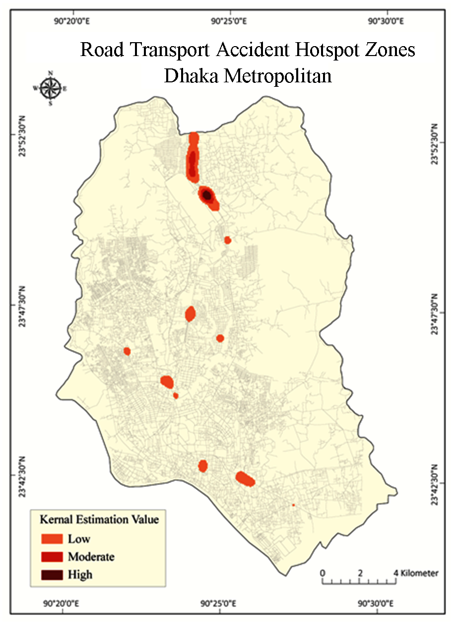
Spatial analysis and spatial statistics tools are used to examine spatial patterns of accidents in Dhaka Metropolitan.
Severity Index of road transport accident (RTA) was calculated to identify the hotspot zones.
There techniques: Cluster and Outlier Analysis (Anselin Local Moran’s-I), Getis-Ord Gi* Statistics and Kernel Density Estimation (KDE) were used for detection and delineation of RTA hotspots.
These analyses revealed about 22 hotspot zones in Dhaka Metropolitan during the years, 2010-2012.
Out of 979 spatial accidents about 458 were located in identified hotspot zones.
ARI [Accident Research Institute] 2014. Accident Research Institute: Road Accident Database.
Chang, K-T., 2004. Introduction to Geographic Information Systems. 4th Ed. New Delhi: Tata McGraw-Hill Publishing Company Ltd.
Hossain, K. T. and Ahmad, A. U., 2014. Assessment of accident hotspots in Dhaka-Aricha highway: Using Kernel Density Estimation (KDE) tool of ArcGIS. Journal of Erath and Environmental Sciences: University of Dhaka, 1(1), 77-81.