Article Title :
Improved Change Detection of Forests Using Landsat TM and ETM plus data 
1 (2017)
18-40
Stable land objects , Forest change detection , Tasseled Cap Coefficient , LST , NDVI , Landsat-7 ETM+ , Landsat-5 TM


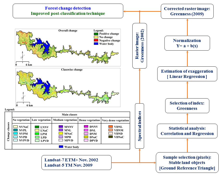
Landsat TM and ETM+ datasets are useful for forest change detection (FCD) at good accuracy level. Classified forest maps have been prepared using NDVI calculated from Landsat-5 TM (2009) and Landsat-7 ETM+ (2002) datasets for FCD using post-classification technique. About 58.59% of reviewed area shows positive changes, 33.69% no-changes and 7.72% negative changes with 77.84% accuracy. This accuracy insists limitations of present FCD analysis. Therefore, improved post-classification technique was formulated for precise FCD using field data and statistical techniques. Information about stable land surface (water bodies, rocky lands, deep forests, etc.) was used for normalisation of exaggerated reflectance in vegetation indices i.e. greenness. About 70.08% land estimated using second approach shows stable vegetation, 23.59% positive changes and 6.33% negative changes. Higher accuracy (95.21%) itself shows improvement in FCD technique and efficient applicability for sustainable land management.

Reliable change detection of forest using remote sensing data is challenging task.
Ground information about stable land objects is useful for correction of target image.
Statistical approach is useful for robust correction and estimations.
Improved change detection technique for forest achieves precise estimations.
The technique can be useful for precise change detection of land.
Dhakal A. S., Amada T., Aniya M. and Sharm R. R., 2002. Detection of areas associated with flood and erosion caused by a heavy rainfall using multitemporal Landsat TM data, Photogram. Eng. Remote Sens., 68, 233-239.
Forkuo E. K. and Frimpong A., 2012. Analysis of Forest Cover Change Detection. International Journal of Remote Sensing Applications, 2 (4), 82-92.
Julien Y., Sobrino J. A., Mattar C., Ruescas B., Jimenez-mun J. A., Sorai G., Hidalgo V., Atitar M., Franch B. and Cuenca J., 2011. Temporal analysis of normalized difference vegetation index (NDVI) and land surface temperature (LST) parameters to detect changes in the Iberian land cover between 1981 and 2001. International Journal of Remote Sensing, 32, 2057-2068.
Morisette J. T., Baret F., Privette J. L., Myneni R. B., Nickeson J. E., Garrigues S., Shabanov N. V., Weiss M., Fernandes R. A., Leblanc S. G., Kalacska M., Sánchez-Azofeifa G. A., Chubey M., Rivard B., Stenberg P., Rautiainen M., Voipio P., Manninen T., Pilant A. N., Lewis T. E., Iiames J. S., Colombo R., Meroni M., Busetto L., Cohen W.B., Turner D. P., Warner E. D., Petersen G. W., Seufert G., and Cook R., 2006. Validation of global moderate-resolution LAI products: A framework proposed within the CEOS land product validation subgroup. IEEE Transactions on Geoscience and Remote Sensing, 44, 1804-1817.
Pajares G., Alonso C., Cruz J. M. and Moreno V., 2002. Shade identification in urban areas through the bayesian classifier, Proc. European Symposium on Intelligent Technologies, 476-481.


