Article Title :
Assessment of Aeolian Desertification Near Vedavathi River Cannel in Central Part of Andhra Pradesh: Remote Sensing Approach 

3 (2019)
39-49
Semi-Arid region , Satellite data , GIS , Desertification , Aeolian sands , Landsat


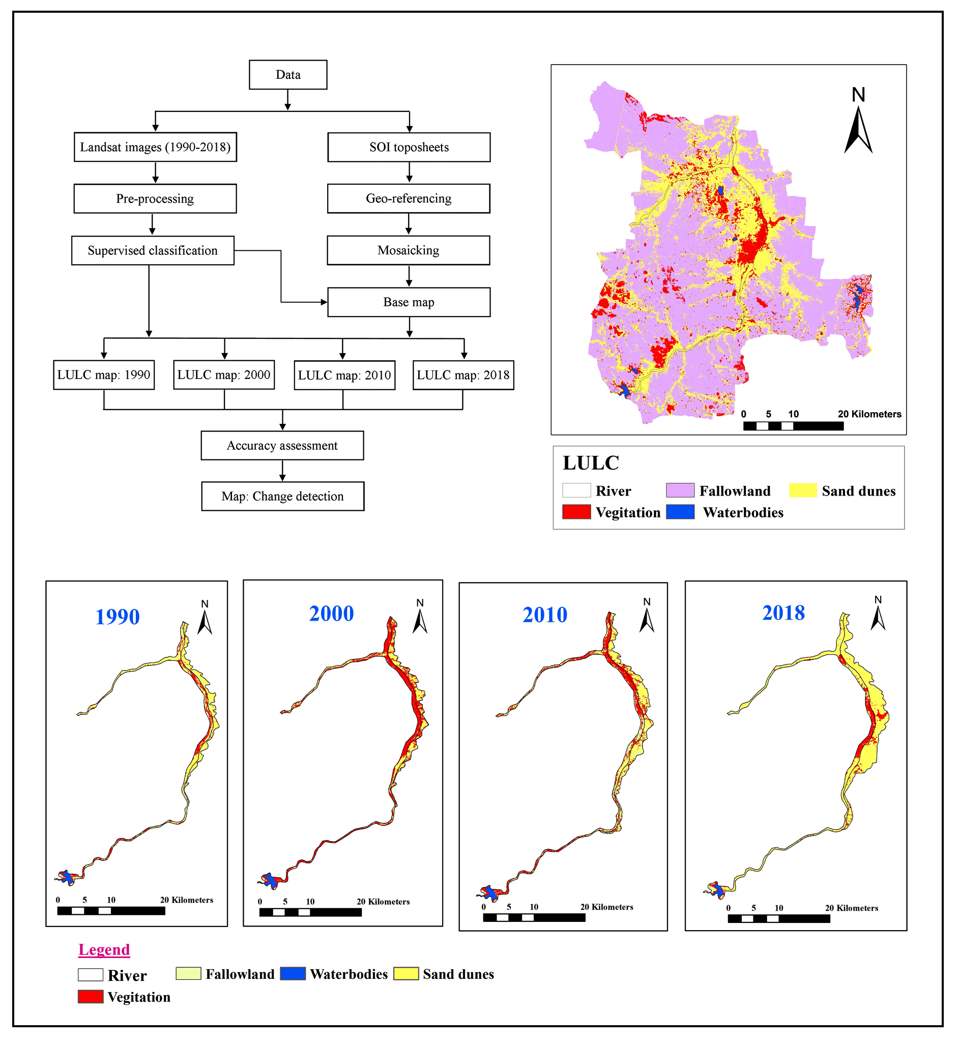
Desertification is one of the foremost environmental and social-economic problems facing the world. Thus, the observation and early detection of desertification is primary objective for scientific and policy organizations, with geospatial techniques as similar as Remote Sensing (RS) and Geographical Information System (GIS) being a candidate choice for the enlargement of monitoring systems. The present study purposes to assess the desertification caused by Aeolian sand deposits near Vedavathi River in a semi-arid region of Anantapur district, aided by temporal data of satellite imageries of past 28 years (1990 to 2018), were collected and processed. The extent of desertified land for the years 1990, 2000, 2010 and, 2018 is assessed, respectively about 28.22 Km2, 33.86 Km2, 46.30 Km2 and, 58.62 Km2. For the past 28 years, the Aeolian sand desertification is increased into the alarming rates with the land extent of 30.4 Km2.
Aeolian desertification is one of the foremost environmental and social-economic problems facing the world.
The River Vedavathi in the lower reaches is selected for detection of desertified area near to the channel.
The spatial database consisted of change detection layers prepared from Landsat 4, 5, 7 and 8 satellite imageries.
Geometric calculation method is used for detection of desertified area.
The Aeolian sand desertification is increased into the alarming rates with the land extent of 30.4 km2 in reviewed period.
The present study can be used by decision makers to develop economically sustainable plan for the protection and management of river environment.
Rajasekhar, M., Gadhiraju, S. R., Kadam, A. and Bhagat, V., 2020. Identification of groundwater recharge-based potential rainwater harvesting sites for sustainable development of a semiarid region of southern India using geospatial, AHP, and SCS-CN approach. Arabian Journal of Geosciences, 13(2), 24.
Rajasekhar, M., Gadhiraju, S. R., Kadam, A. and Bhagat, V., 2020. Identification of groundwater recharge-based potential rainwater harvesting sites for sustainable development of a semiarid region of southern India using geospatial, AHP, and SCS-CN approach. Arabian Journal of Geosciences, 13(2), 24.
Rajasekhar, M., Gadhiraju, S. R., Kadam, A. and Bhagat, V., 2020. Identification of groundwater recharge-based potential rainwater harvesting sites for sustainable development of a semiarid region of southern India using geospatial, AHP, and SCS-CN approach. Arabian Journal of Geosciences, 13(2), 24.
Amal, K., 2016. Desertification, Central Arid Zone Research Institute (CAZRI).
Anonymous, 2003. Desertification Status Mapping- Technical Guidelines. Forest, Land use and Photogrammetry group, RESIPA, Space Application Venter, Ahmadabad, 34.
Dhinwa, P. S., Dasgupta, A. and Ajai, 2016. Monitoring and assessment of desertification using satellite remote sensing. Journal of Geomatics, 10(2), 201-216.
GSI [Geological Survey of India], 2002. Geological Survey of India District Mineral Resources Map Anantapur, Andhra Pradesh, India.
Harshika, A. K. and Sopan I., 2012. Land use land cover classification and change detection using high resolution temporal satellite data. Journal of Environment, 01(04), 146-15.
Jenness, J. and Wynne, J. J., 2007. Kappa analysis (kappa_stats. avx) extension for ArcView 3x. Jenness Enterprises.
Pradeep Kumar, B., Raghu Babu, K., Rajasekhar, M. and Ramachandra, M., 2019. Assessment of land degradation and desertification due to migration of sand and sand dunes in Beluguppa Mandal of Anantapur district (AP, India), using remote sensing and GIS techniques. The Journal of Indian Geophysical Union, 23(2), 173-180.
Pradeep Kumar, B., Rajasekhar, M., Ramachandra, M. and Siva Kumar Reddy P., 2018. Assessment of land degradation and desertification due to migration of sand dunes - A case study in Bommanahal Mandal, Anantapur district, Andhra Pradesh, India using Remote Sensing and GIS techniques. IJRAT, 6 (6), 1-7.
Pradeep Kumar. B., Raghu Babu. K., Rajasekhar M. and Narayana Swamy, B., 2019. Change detection analysis of Land Use and Land Cover in Tadimarri mandal of Anantapur district, AP, India, using Geospatial Techniques. IJRAR- International Journal of Research and Analytical Reviews, 6(2), 634-640.
Rajasekhar, M., Sudarsana. Raju, G., Siddi Raju, R., Ramachandra, M. and Pradeep Kumar, B., 2018b. Data in brief data on comparative studies of lineaments extraction from ASTER DEM, SRTM and Cartosat for Jilledubanderu River basin, Anantapur district, A. P, India by using remote sensing and GIS. Data in Brief, 20, 1676-1682.
Rajasekhar, M., Gadhiraju, S. R., Kadam, A. and Bhagat, V., 2020. Identification of groundwater recharge-based potential rainwater harvesting sites for sustainable development of a semiarid region of southern India using geospatial, AHP, and SCS-CN approach. Arabian Journal of Geosciences, 13(2), 24.
Rajasekhar, M., Raju, G. S., Raju, R. S. and Basha, U. I., 2017. Landuse and landcover analysis using remote sensing and GIS: A case study in Uravakonda, Anantapur District, Andhra Pradesh, India. IRJET, 4(9), 780-785.
Reynolds, J. F., Maestre, F. T., Kemp, P. R., Stafford-Smith, D. M. and Lambin E., 2007. Natural and human dimensions of land degradation in drylands: Causes and consequences. In: Canadell J. G., Pataki D.E., Pitelka L.F. (eds) Terrestrial Ecosystems in a Changing World. Global Change - The IGBP Series. Springer, Berlin, Heidelberg.
Sreenivasulu, G., Jayaraju N. and Lakshmi P. T., 2014. Landuse and landcover analysis using remote Sensing and GIS: A case study in and around Rajampet, Kadapa District, Andhra Pradesh, India. IJMRD, 2(1), 186-191.
Thomas, D. S. G. and Middleton, N. J., 1994. Desertification: Exploding the Myth. John Wiley & Sons Ltd., Chichester, UK.
UNCCD [UN Conference on Desertification], 1978. Round up, plan of Action and Resolutions, New York.
UNEP, 1992. Desertification, Land degradation [definitions]. Desertification Control Bulletin 21.