

Article Title :
Impact Assessment of Water Harvesting Structures in Micro-Watersheds of Nira River Basin, Maharashtra, India 

3 (2019)
72-89
Water Harvesting Structures , VES , Nira , Impact Assessment , Basin


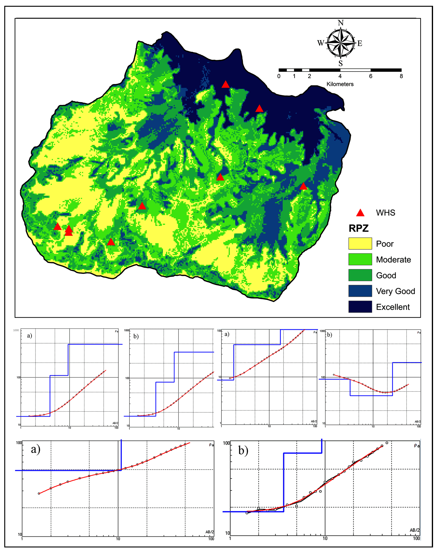
Artificial recharge is highly recommended in declining groundwater level trends as well as partially replenished aquifers. Moreover, the quantification of the recharge to aquifers due to such measures is important in water resource budgeting, development and planning. With this objective nine locations representing varied geomorphology were selected and the groundwater levels from the dug well in the proximity of water harvesting structures were monitored. The plot of monthly groundwater levels versus rainfall depicts that in the month of July high rainfall occurred but the groundwater levels raised in August due to delayed recharge process. The water level data also indicate the availability of water column of about 5m to 6m in most of the wells till the end of February, 2020. Water Harvesting structures overlaid on the Recharge Potential Zone map represent excellent (13.1%), very good (12.3%), good (23.3%), moderate (25.2) and poor (26.1) zones. The computation of artificial recharge from these structures depict that the structures having high storage capacity with a greater number of fillings have higher recharge. Also, the geophysical resistivity surveys were conducted to understand the degree of saturation at each location up to 50m, 100m and 150m distances from the structure. After integrating all datasets, it has been found that the structure at Shivajinagar has highest recharge followed by Pisalwadi, Kanheri, Zagalwadi 2, Kavathe, Ansur, Bholi, Limbachidwadi, Zagalwadi 1 and Kesurdi. Thus, the study concludes that the impact of water harvesting structures varies according to topography, land slope, geomorphology, size of catchment and lithology.
Water harvesting structures (WHSs) are important to recharge groundwater for sustainable development.
Nine locations were selected and water levels in dug wells were monitored in the proximity of WHSs.
Recharge Potential Zone map was prepared with excellent (13.1%), very good (12.3%), good (23.3%), moderate (25.2) and poor (26.1) zones.
The geophysical resistivity surveys were conducted to understand the degree of saturation at each location.
The impact of water harvesting structures varies according to topography, land slope, geomorphology and nature of watershed.
Al-shabeeb, A. R. R., 2015. A modified analytical hierarchy process method to select sites for groundwater recharge in Jordan. Doctoral dissertation, University of Leicester.
Grum, B., Woldearegay, K., Hessel, R., Baartman, J. E., Abdulkadir, M., Yazew, E. and Geissen, V., 2017. Assessing the effect of water harvesting techniques on event-based hydrological responses and sediment yield at a catchment scale in northern Ethiopia using the Limburg Soil Erosion Model (LISEM). Catena, 159, 20-34.
Kadam A. K., Sankhua R. N., Jain R. K., Umrikar B. N. and Srivastava, R., 2017b. Site suitability analysis for small multi-purpose dams using rock ware. Third National Dam Safety Conference compendium of technical papers, Ministry of Water Resources, GoI, 360-365.
Kadam, A. K. and Sankhua, R. N., 2012. Ground water prospect mapping of upper Karha watershed using GIS with spatial reference to ArcCN- Runoff. National Water Academy, Pune., India. Water Week-Water, Energy and Food Security: Call for Solution, 10-14
Narayana, V. V. D. and Sastry, G., 1986. Design of earth dams for water harvesting and erosion control in Shiwaliks. Journal of Institution of Engineers (India), 67, 110-114.
Osunbitan, J. A., Oyedele, D. J. and Adekalu, K. O., 2005. Tillage effects on bulk density, hydraulic conductivity and strength of a loamy sand soil in southwestern Nigeria. Soil and Tillage Research, 82(1), 57-64.
Rajasekhar, M., Gadhiraju, S. R., Kadam, A. and Bhagat, V., 2020. Identification of groundwater recharge-based potential rainwater harvesting sites for sustainable development of a semiarid region of southern India using geospatial, AHP, and SCS-CN approach. Arabian Journal of Geosciences, 13(2), 24.
Ramakrishnan, M. and Vaidyanadhan, R., 2010. Geology of India, (1and 2). GSI Publications, 2(1).
Reddy, K. S., Ricart, S., Maruthi, V., Pankaj, P. K., Krishna, T. S. and Reddy, A. A., 2020. Economic assessment of water harvesting plus supplemental irrigation for improving water productivity of a pulse–cotton based integrated farming system in Telangana, India. Irrigation and Drainage, 69(1), 25-37.

