Article Title :
Sites Suitability Analysis of Potential Urban Growth in Pabna Municipality Area in Bangladesh: AHP and Geospatial Approaches 

3 (2019)
82-92
AHP , GIS , Modeling , Suitability Analysis , Urban growth , Urbanization


For a long prior time, planning is being deprived of resulting unplanned urban growth that happen consequences the urban problems. A GIS-based site suitability analysis using the AHP model is performed with criterion: land use, population distribution, water network, drainage network and road network. The suitable growth sites are determined through expert opinion, pair-wise comparison matrix and finally determining the weighted value. This paper found out the potential urban growth mainly in ward no. 2, 7, and 6. Optimally suitable places are those sites where future urban development can easily occur and have all the required facilities with available commercial, industrial, and official land use, moderate and highly suitable places need some facilities e.g., water supply, drainage management, road network and rearrangement of land use. Very few and partly suitable sites need major involvement of facilities and revisions of present land use for potential urban development. This information can be useful for policy makers for planning processes as an acceptable scientific process for site suitability analysis in the municipality area for avoiding the urban problems and ensuring sustainable development.
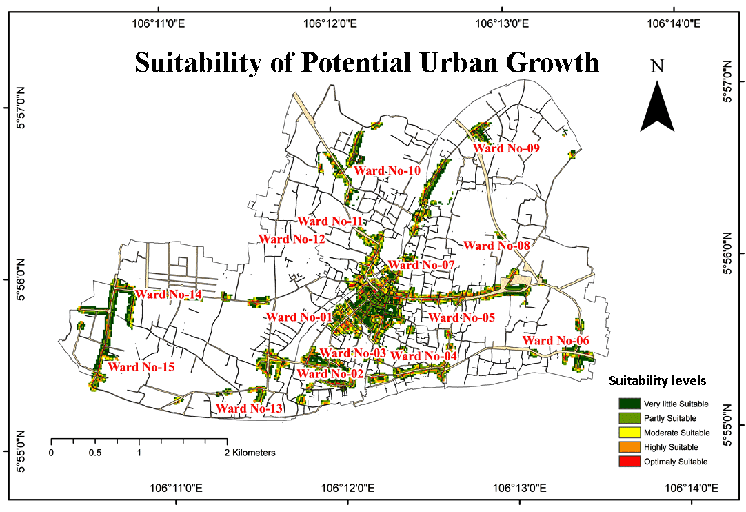
A GIS-based site suitability analysis using the AHP model is useful for policymakers to make proper planning.
Five criterions: land use, population, water-, drainage- and road network were used for the analysis.
Score values were assigned based on expert opinions and previous studies.
Urban land was classified into: Optimally suitable, mostly suitable, moderate suitable, partly suitable and very little suitable sites for potential urban growth in the Pabna municipality Area.
BBS [Bangladesh Bureau of Statistics], 2011. Bangladesh Bureau of Statistics, Cultural Survey Report of Pabna Sadar Upazila.
MIDP [Municipality Infrastructure Development Plan], 2008. Municipality Infrastructure Development Plan, Pabna.
Raddad, S. and Salleh, A., Samat, N., 2010. Determinants of agricultural land-use change in palestinian urban environment: Urban planners at local governments perspective. American-Eurasian Journal of Sustainable Agricultural, 4, 30-38.
Saaty, T. L., 1980. The Analytical Hierarchy Process; McGraw-Hill: New York, NY, USA, 1980.
Yager, R. R., 1996. Quantifier guided aggregation using OWA operators. International Journal of Intelligent Systems, 11(1), 49-73.