Article Title :
Updating Topographic Maps at Scale 1:250000 for Libyan Territory Using Quantum GIS (QGIS) and Open Geospatial Data: Libya Topo-Project 
4 (2020)
22-34
GIS , Remote Sensing , VGI , OSM , Crowd Sourced GIS , Mapping


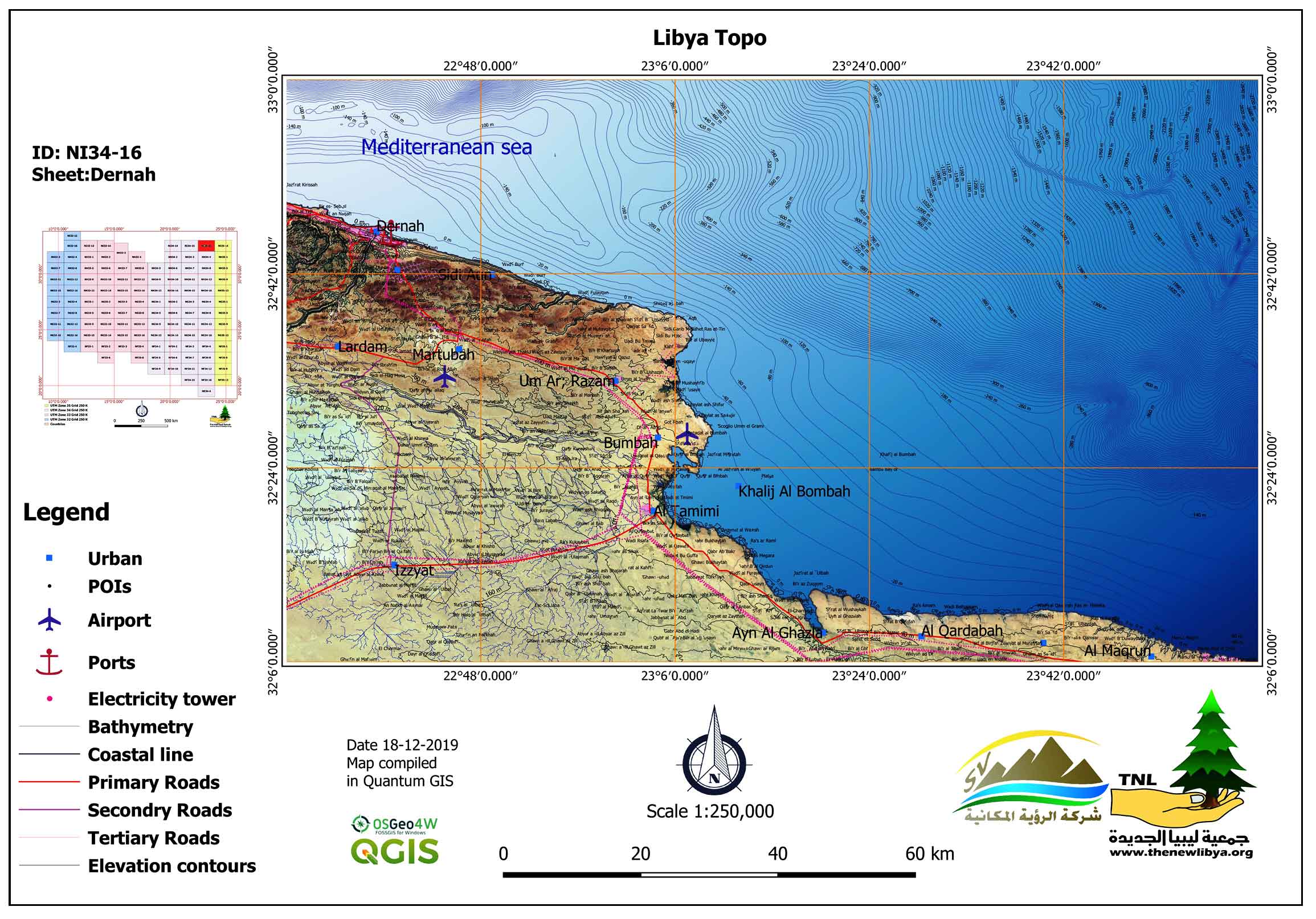
From the beginning of the twentieth century, topographic maps for the Libyan state carried out by various compilers, where the first mapping was carried out by the Italian Military Geographical Institute, the Soviet Union Military, and the U.S. Army, followed by mapping carried out by the Libyan state from the 1950s to the 2000s. Most of these maps have not been digitized and updated using the techniques of geographic information systems and remote sensing. This paper discusses on the objectives, methodology and results of the Libya Topography Project, “Libya Topo” for updating the previously compiled topographical map at scale, 1:250000. Open spatial data from different platforms (OSM, Logistics Cluster, Landsat 8 satellite imagery, and SRTM data, etc.). Also, POIs extracted from previously compiled topographic and geological maps. Spatial database for each UTM zone created to store the features and raster. As for the cartographic style, the map layout adopted is the style of the U.S. Defense Mapping Agency maps. The results of the project are an update of 121 topographical map sheets using Quantum (GIS), those will be freely available for the interested users on request (e.g., environmentalists, academics, and university students, etc.).
Most of the worldwide national mapping development originated in the military survey.
Updating maps is crucial as many specialists, planners, and decision-makers rely strongly on topographic maps for planning and development.
The updating of previously compiled topographic maps with modern ones to keep up to date with the developments and changes that have occurred on land.
Most of the maps that are available for Libya their contents dated back to the time of their production and only the printing renewed.
Libya Topo-project launched to Identify and develop proposals to help solve issues related to the production and updating of topographical maps in Libya.
The result of the update of 121 topographical maps was based on open-source GIS data and generated using QGIS software.
Chand, J., 2014. Free and open source software’s for Geographic Information System (GIS). European Academic Research 1(12): 5277-5291.
IRC [Industrial Research Center] 1984. Libya Geological map of Libya scale 1:250,000.
IRC [Industrial Research Center], 1974. Geological Maps of Libya.
LSA [Libyan Survey Authority], 1976-2004. Topographic maps of Libya scale 1:250,000 and 1: 50,000.
QGIS-DT [QGIS Development Team], 2017. QGIS Geographic Information System. Open Source Geospatial Foundation Project.
US-AMS [US Army Map Service], 1963. Libya Topographic Maps scales; 1:500,000; 1:250,000 and 1:200,000 1:50,000.
US-NIMS [National Imagery and Mapping Service]. 2000. Topographic maps of Libya scale 1: 50,000.