
Journal Open access Double-blind peer review
Journal of Geographical Studies
In association with the Department of Geography, Jamia Millia Islamia (A Central University), New Delhi
'Journal of Geographical Studies' (JGS) publishes double-blind peer-reviewed articles within all fields of geography.
Editor-in-Chief Professor. Masood Ahsan Siddiqui (Department of Geography, Jamia Millia Islamia – A Central University, New Delhi-110025 (India).)
Managing Editor Dr. Kalpana Bhagat  (Gatha Cognition.)
- Articles published
- 59
- Crossref citations
- 277
- Citation ratio · Crossref
- 4.69
- Citation ratio · OpenAlex
- 7.37
- Days to first decision
- 124
Citation ratio = citations ÷ all articles published since the first issue. Days to first decision = median days from submission to the editor’s first decision, for the last 20 manuscripts (submitted since April 2023).
Issue
Volume 4 (2020) · Issue 1-2
Original Research Paper
-
pp. 1-9 Open access
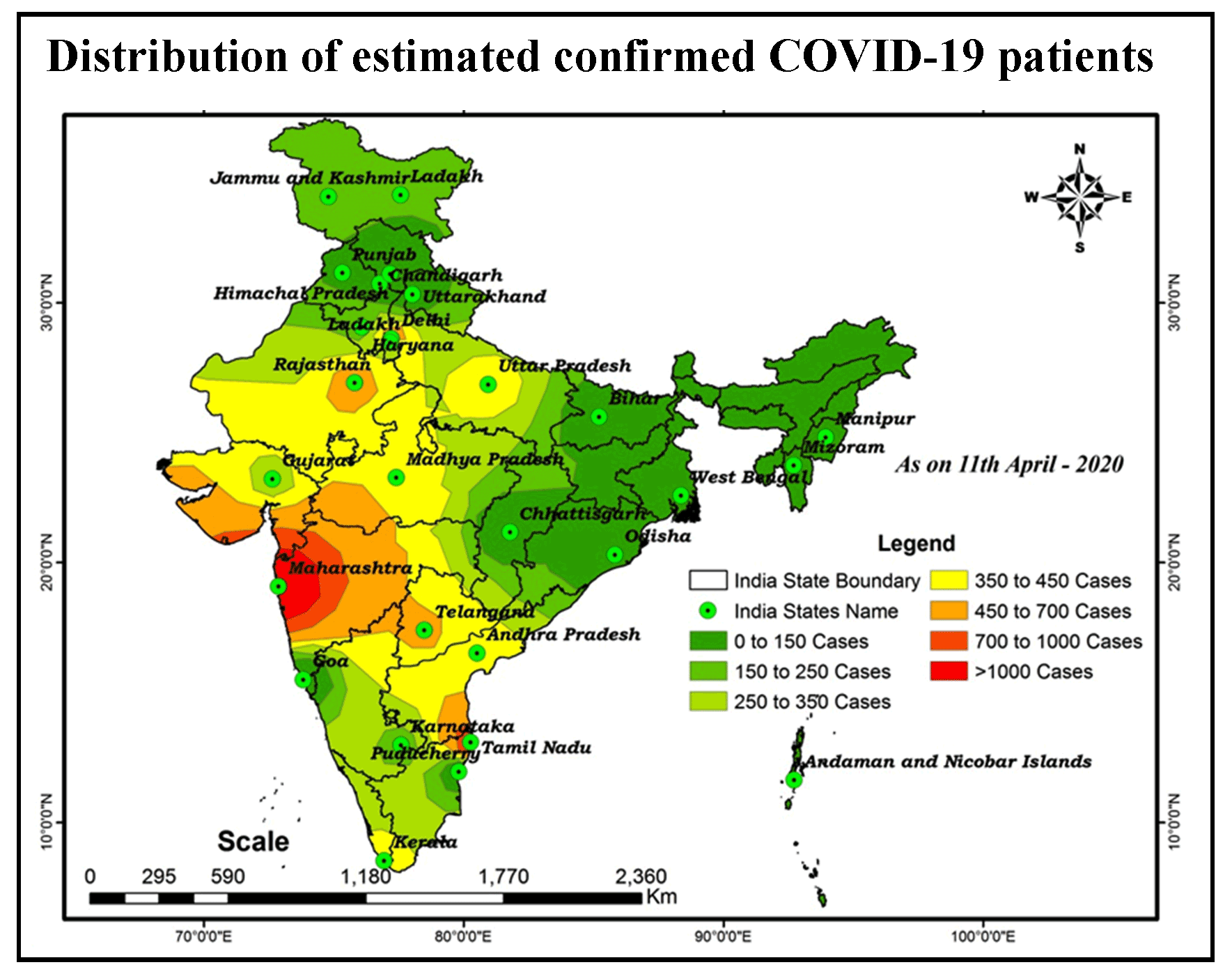
Distribution and Trend Analysis of COVID-19 in India: Geospatial Approach
Murugesan Bagyaraj, SHANKAR KARUPPANNAN, Alemayehu Tenaw Mengistie, Gnanachandrasamy Gopalakrishnan
COVID-19 Coronavirus is now one of the most contagious diseases of the recently discovered and spread across the China in 2019 and has received global attention. In most COVID-19-infected individuals, respiratory symptoms should be mild to moderate and improve without the need for medical care. The risk of serious disease is higher for senior citizens and people with serious health problems, such as heart disease, di…
10.21523/gcj5.20040101 1,402 views 55 citations 15 Apr 2020
-
pp. 10-21 Open access
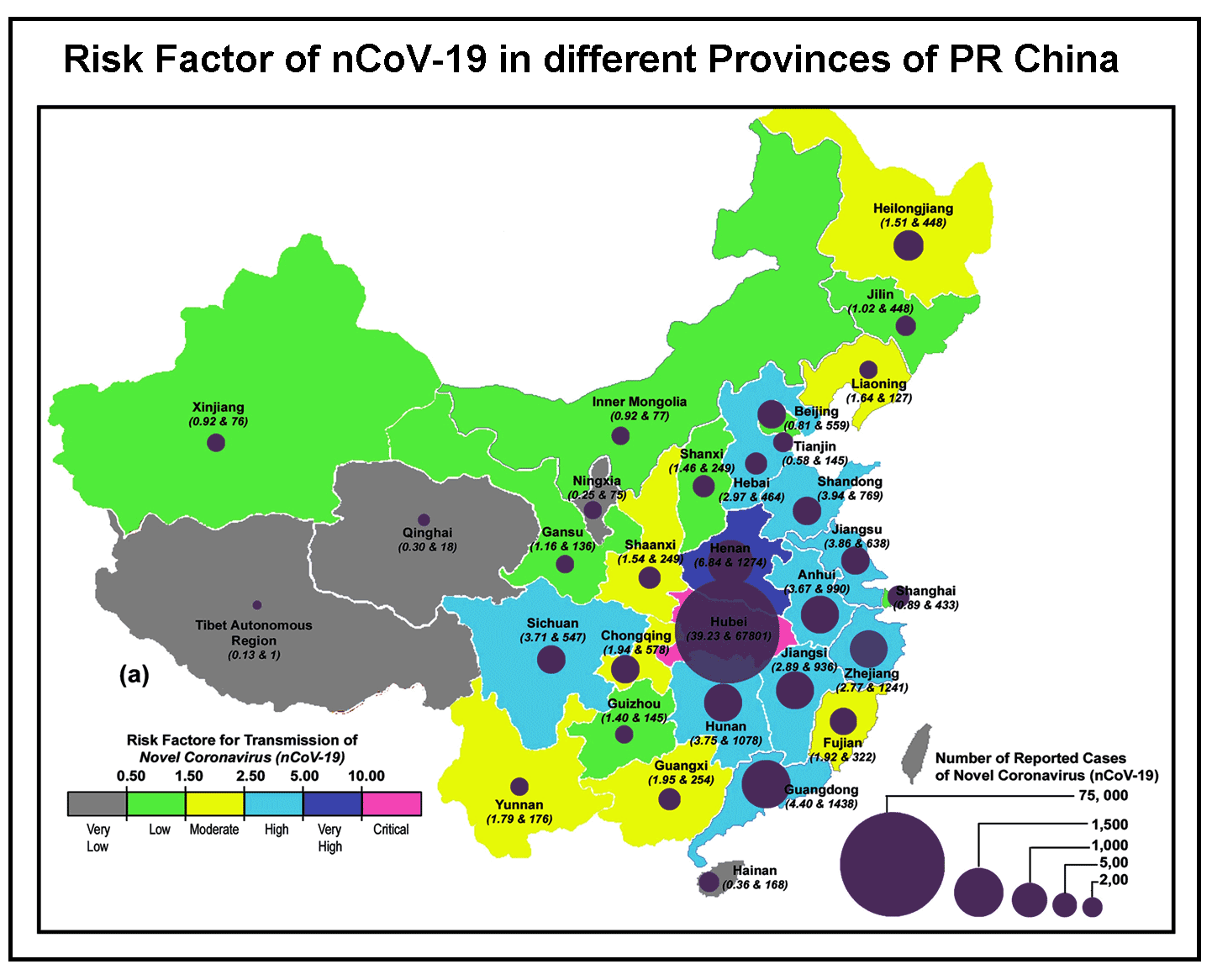
Transmission Dynamics of Novel Coronavirus nCov-19 from Wuhan to Rest of the World
SUMAN PAUL, Subhasis Bhattacharya, Subrata Haldar, Somnath Mandal, Sanjit Kundu, Anupam Biswas
The study tries to understand the aftermath infection breakout scenario pattern of Novel Coronavirus (nCov-19) from a Chinese city which is twofold in nature as per its purpose to understand its breakout and to discuss its sequential spreading over the globe. The study considers the variables responsible for such outbreak all over the globe with variation in its spreading rate or growth pattern. Social factors, behav…
10.21523/gcj5.20040102 1,185 views 1 citation 25 May 2020
-
pp. 35-43 Open access
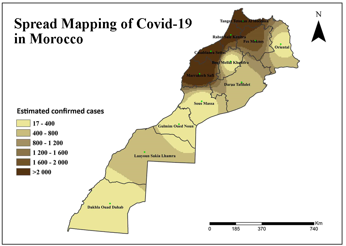
Spread Mapping of Covid-19 in Morocco Using Geospatial Approach
Elhoucein LAYATI, Abdellah Ouigmane, Marcelo de Carvalho Alves, Murugesan Bagyaraj, Mohamed elghachi
Most of the people infected in Morocco are triggered by the outbreak of COVID-19. The number of affected cases is currently rising day by day. As of July 16th, 2020, In Morocco, 15,165 cases were tested positive for COVID-19, including 239 deaths and 11,417 patients cured the highest number of Corona virus cases reported as Ministry of Health Department in Morocco. The COVID-19 virus threatens the health, economy, de…
10.21523/gcj5.20040104 908 views 4 citations 24 Sep 2020
-
pp. 45-63 Open access
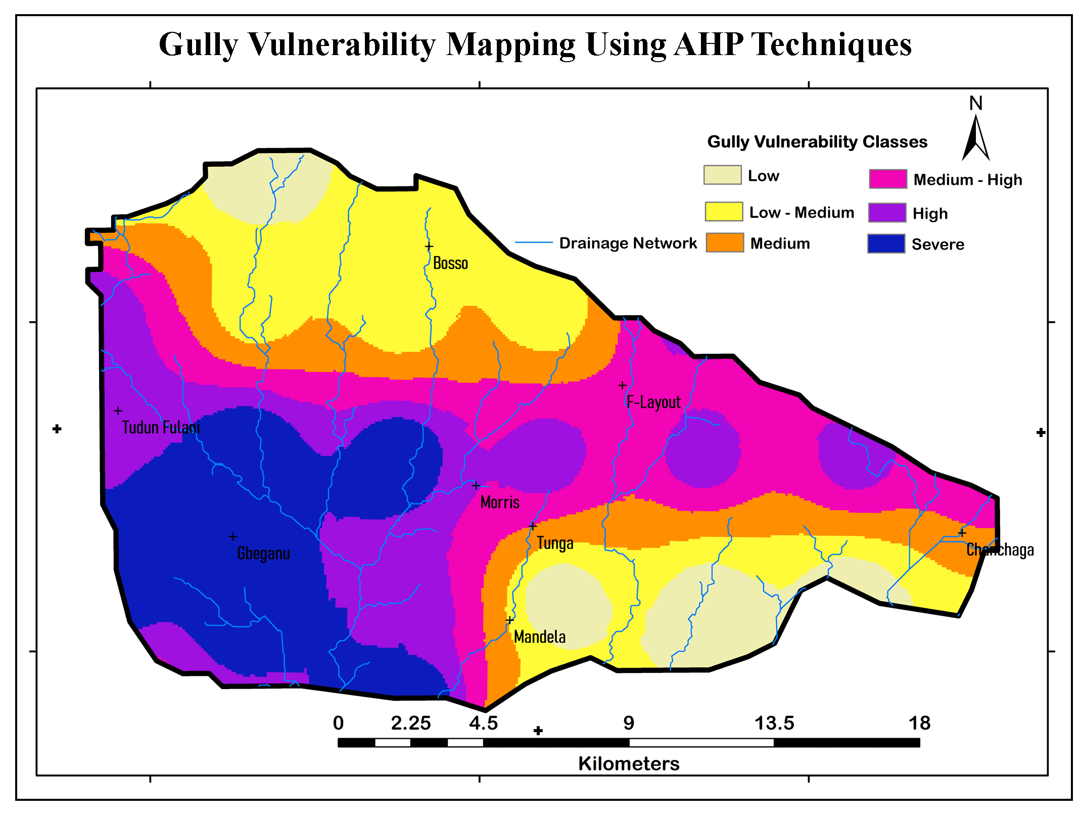
GIS-based MCDA for Gully Vulnerability Mapping Using AHP Techniques
BASHIR ISHAKU YAKUBU, Sallau Rachel Osesienemo, Sheikh Abubakar Danjuma, Aminu Zunni, Hassan Shu’aib Musa
This paper explores the potentiality of GIS-based Multi-Criteria Decision Analysis (MCDA) and Analytical Hierarchy Process (AHP) for gully vulnerability mapping. Multilayer information of basin characteristics, such as drainage density, Topographic Wetness Index (TWI), Stream Power Index (SPI), slope aspect and land use land cover (LULC), were used in this study to develop a Gully Vulnerability Index (GVI). A weighte…
10.21523/gcj5.20040201 3,211 views 4 citations 19 Oct 2020
Technical Paper
-
pp. 22-34 Open access
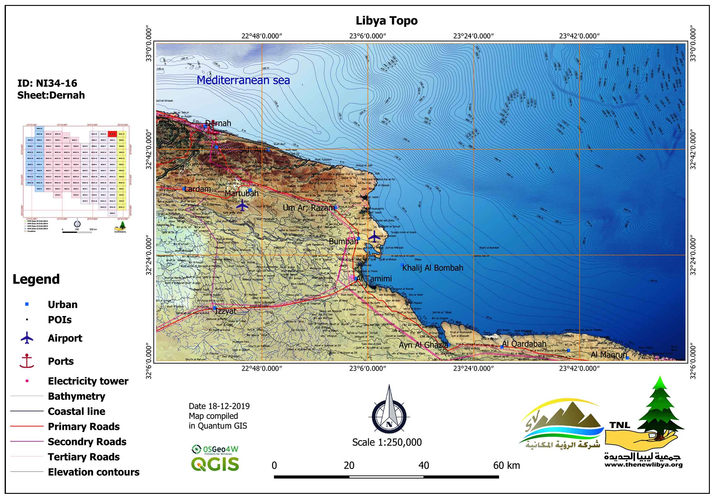
Updating Topographic Maps at Scale 1:250000 for Libyan Territory Using Quantum GIS (QGIS) and Open Geospatial Data: Libya Topo-Project
From the beginning of the twentieth century, topographic maps for the Libyan state carried out by various compilers, where the first mapping was carried out by the Italian Military Geographical Institute, the Soviet Union Military, and the U.S. Army, followed by mapping carried out by the Libyan state from the 1950s to the 2000s. Most of these maps have not been digitized and updated using the techniques of geographi…
10.21523/gcj5.20040103 3,362 views 6 citations 13 Sep 2020
Credits to reviewers (52)
- Dr. Vijay Bhagat, Post-graduate Research Centre in Geography, Agasti Arts, Commerce and Dadasaheb Rupwate Science College, Akole-422601, Ahmednagar, Maharashtra (India).
- Dr. Suyash Kumar, Geology Department, Govt. PG Science College, Gwalior, MP 474009 India.
- Dr. Nitin Mundhe, Post Graduate Teaching & Research Centre, Department of Geography, S. P. College, Pune
- Dr. Archana Patil, RNC Arts, JDB Commerce and NSC Science College, Nashik Road, India
- Dr. Ravindra Medhe, Department of Geography, Savitribai Phule Pune University, Pune
- Dr. Chaitanya Pande, All India coordinate research project for dry land agriculture, Dr. Panjabrao Deshmukh Krishi Vidyapeeth, Akola
- Dr. BHAVANA Umrikar, Department of Geology, Savitribai Phule Pune University, Pune - 411 007 (India).
- Dr. Sanjay Kale, Department of Environmental Sciences, University of Pune, Pune- 411 007.
- Dr. Driss Bouyahya, Moulay Ismail University, Meknès Morocco School of Arts and Humanities
- Dr. Sainath Aher, Post Graduate Department of Geography, S. N. Arts, D. J. Malpani Commerceand B.N. Sarda Science College, Sangamner 422 605, India
- Dr. Mohammad Suhail, AS College, Lakhaoti, BSR, CCS University, Meerut, Uttar Pradesh (India).
- Professor. Shahida Murtaza, Deartment of Women Education,Maulana Azad National Urdu University,Gacchibowli,Hyderabad. 5000032Telengana.India.
- Dr. Taruna Bansal, Department of Geography, Jamia Millia Islamia - A Central University, New Delhi-110025 (India).
- Prof. Lubna Siddiqui, Department of Geography, Jamia Millia Islamia, New Delhi-110025 (India).
- Dr. Saif Said, Department of Civil Engineering, Z. H. College of Engineering and Technology, Aligarh Muslim University (AMU), Aligarh U.P. (India).
- Professor. Shahab Fazal, Department of Geography, Aligarh Muslim University, Aligarh, UP
- Dr. Ananad Malik, Swami Sharadhanand College, Delhi University
- Dr. Firdous Azmat Siddiqui, Sarojini Naidu Centre for Women's Studies, Jamia Millia Islamia, New Delhi
- Mr. Gajendra Singh Yadav, AFC
- Professor. Mohd. Firoz Khan, Department of Geography, JMI, New Delhi
- Dr. Raihan Ahmed, Department of Geography, Jamia Millia Islamia, New Delhi
- Professor. Somnath Dasgupta, Chair Professor, Department of Geography, Jamia Millia Islamia, New Delhi
- Dr. Abhay Kumar, Lokashraya Foundation, A-101, Gauri Sadan, 5-Hailey Road, New Delhi-110001
- Dr. R Islam, Wadia Institute of Himalayan Geology
- Dr. Ajaykumar Kadam, Department of Geology, Savitribai Phule Pune University, Pune
- Professor. Nizamuddin Khan, Department of Geography, AMU Aligarh
- Professor. Abdul Muneer, AMU Aligarh
- Dr. Rajasekhar M, Department of Geology, Yogi Vemana University, Kadapa-516003, Andhra Pradesh (India).
- Dr. Rahul Todmal, VP's ASC College Baramati, Pune (Maharashtra)
- Dr. K. V. Suryabhagavan, School of Earth Sciences, Addis Ababa University, P.O. Box 1176, Addis Ababa, Ethiopia.
- Prof. Syed Ahmad Ali, Department of Geology, AMU Aligarh
- Dr. SHANKAR KARUPPANNAN, Department of Aplied Geology,School of Applied Natural Sciences (SoANS), Adama Science & Technology University, Adama, Ethiopia.
- Dr. Nanabhau Kudnar, C. J. Patel College Tirora, Gondia
- Mr. Sumit Das, Savitribai Phule Pune University, Pune
- Dr. Arun Magar, Department of Geography, Tuljaram Chaturchand College of Arts, Science and Commerce College, Vivekanand Nagar, Baramati- 413102,Maharashtra (India).
- Dr. Santosh Bhailume, Department of Geography, K.V.N. Naik College Nashik
- Prof. Biplab Biswas, Department of Geography, Bardawan University, West Bengal
- Miss. Abhra Singh, Jamia Millia Islamia, New Delhi
- Professor. Mamdouh El-Hattab, Institute of Environmental Studies and Research, University of Sadat City, Egypt.
- Dr. Yogesh Badhe, Department of Geography, Savitribai Phule Pune University, Pune - 411 007 (India).
- Dr. Sagar Mali, Department of Geography,Vidya Prabodhini College of Commerce, Education, Computer and Management, Vidyanagar, Alto-Parvari-Goa.
- Dr. Murugesan Bagyaraj, Department of Geology, College of Natural and Computational Sciences, Debre Berhan University, Debre Berhan, Ethiopia.
- Dr. Selvakumar P, Department of Chemical Engineering, ASTU, Adama, Ethiopia.
- Dr. Md. Baharuddin Shah, P. G. Department of Geography, G. P. Women's College, DHANAMANJURI UNIVERSITY, Imphal
- Dr. Shrinwantu Raha, Bhairab Ganguly College, Belgharia-7,000,56, West Bengal, India.
- Professor. Arjun Doke, Baburaoji Gholap College Sangavi Pune-27 Maharashtra India
- Dr. Sanjay Navale, Department of Geography, S. N. Arts, D.J.M. Commerce and B.N.S. Science College, Sangamner, Dist.Ahmednagar, Maharashtra (India), 422605.
- Professor. Rajendra Zolekar, Department of Geography, K.V. N.Naik College Nashik
- Dr. Shah Fahad, Department of Geography, Institute of Science, Banaras Hindu University, VARANASI
- Dr. Adnan Shakeel, Jamia Millia Islamia, New Delhi
- Professor. Poonam Sharma, Shaheed Bhagat Singh College, University of Delhi, Sheikh Sarai , Phase-II, New Delhi 110017, India
- Dr. MD. Kaikubad Ali, Department of Geography, Jamia Millia Islamia