1 . INTRODUCTION
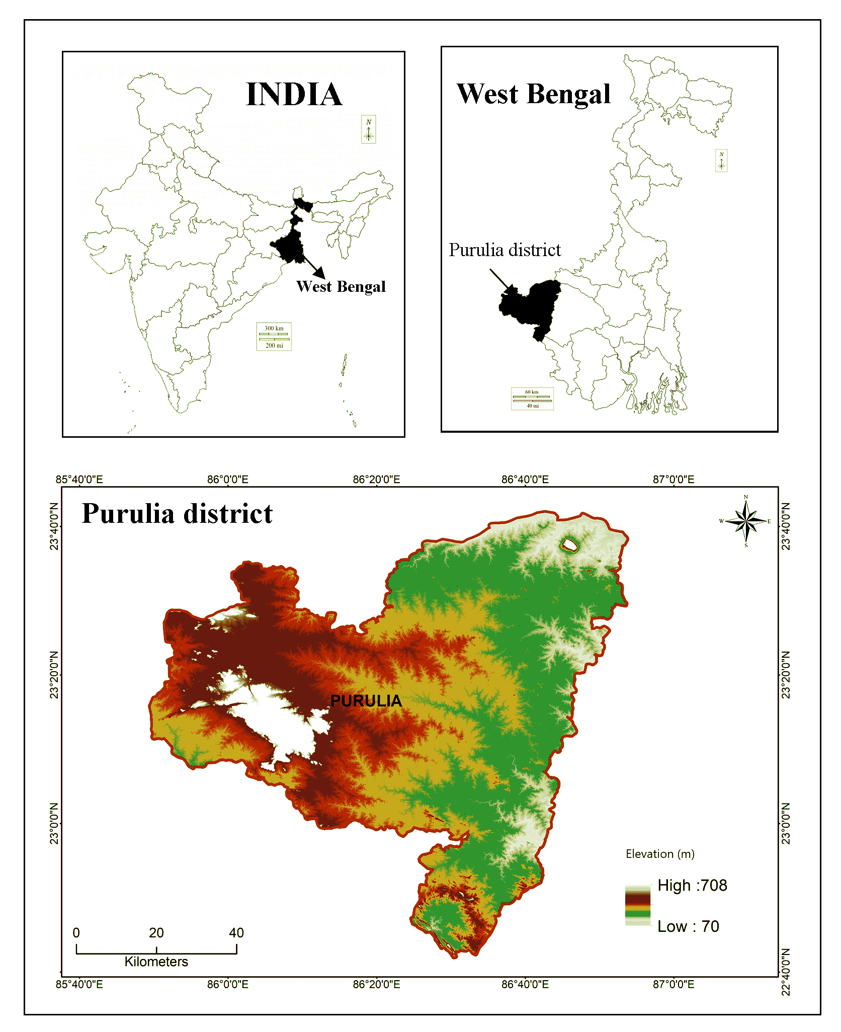
The conceptual definition of ecotourism is a form of tourism, which is ecologically responsible, economically viable with minimum environmental damage and respect towards the cultural tradition of indigenous people. It ensures an ethical visit to natural site, makes a contribution to the preservation of the natural environment and helps to improve the standard of living of the local community (TIES, 2015; Elena and Thomas, 2018). Ecotourism as a substitute for traditional tourism has become increasingly popularize due to detrimental effects that conventional tourism had on both the natural environment and the cultural practices of the native population (Dwyer et al., 2010). The conventional way of tourism severely impacted the environment, loss of habitats and destruction of nature and natural landscape, pressurizing local resources and the loss of cultural uniqueness of the local community (Palazzo et al., 2022; Sunlu, 2003; Liu et al., 2014). The fundamental difference between conventional tourism and ecotourism is how they interact with nature; conventional tourism is less concerned with the welfare of locals and the preservation of nature, whereas ecotourism aims to have the least possible negative effects on both the environment and people (Kontogeorgopoulos, 2004; Singh, 2015; Jackson, 2022). Ecotourism, namely an alternative form of tourism that gives travelers ecological experience, feels the uniqueness of nature encouraged them to protect the ecological landscape and benefit the local communities economically and help them preserve the environment (Ullah and Hafiz, 2013; Wight, 1993). The concept of ecotourism popularized in 1990s, came out as reaction of traditional tourism which less bother about environment, severely affect diversity, environment and culture of indigenous people. Ecotourism emerged as a potential and effective tool to address the drawbacks of conventional tourism with the aim of sustainable development and empowers locals with financial security (Bunruamkaew et al., 2011; Reddy, 2019). Due to many beneficial aspects of ecotourism, developing countries of the world are interested for investing in ecotourism sector as a tactical tool for their economic growth and conservation strategies to build environmental awareness (Stem et al., 2003). In order to develop land for ecotourism, one must engage in meticulous planning and the gradual inclusion of land while keeping in mind the need of preserving the natural environment (Kiper, 2013; Burgoyne and Mearns, 2022). Ecotourism development needs to be managed and adapted to the local ecosystem’s sensitivity and natural values if it is to have a less detrimental impact. The increasing number of people interested in ecotourism and the conservation prospects it present one-of-a-kind opportunities to integrate rural development, tourism resource management and protected area management in a variety of locations across the globe. For several nations, like Costa Rica, Cambodia, Laos, Thailand, Maldives, Bhutan, etc., ecotourism is not a simple recreational activity to support financial assistance for protection of environment but also provides a sizeable economic contribution to the host country (UNWTO, 2013; Manzoor et al., 2019). Ecotourism as a concept relatively new one in India though it has the tremendous potentiality of ecotourism because of diversifying natural landscapes and rich flora and fauna (Patel, 2020). India is blessed with a diverse range of natural marvels, from the snow-capped panoramic view of the Himalayan Mountain in the north to the quaint and refreshing seacoast of Kanyakumari in the south. In contrast, the western part of India is full of magnificence glory and cultural paradise of the deserts in Rajasthan, whereas Northeast portion of India covered with rare and exotic flora and fauna that yet to be unexplored. India thus has the potential to develop into a popular ecotourism destination as a consequence of its abundant natural wealth. Present study area Purulia district is one of the potential destinations of ecotourism in the state of West Bengal (India), with its splendid natural landscape hills, forests and wildlife sanctuaries, rivers, reservoirs, waterfalls, places of historical importance, tribal culture and crafts that offer us perfect destination of a nature lover to explore the ecotourism spots. Tourists are always searching for the most advantageous and convenient location for staying from where the rest of the targeted areas can be explored (Ilban and Yıldırım, 2017). Every traveler has a different view and preference before choosing tourist destination based on beneficial factors such as natural beauty, connectivity, food preferences, cultural attractiveness and non-beneficial factors rugged topography, harsh climate, per day cost, distance, safety and security (Pileliene and Grigaliunaite, 2019).
Particularly, in the light of ecotourism advancements, remote sensing and GIS have become essential tools for exploring and monitoring tourism resources. GIS considered as one of the powerful, cost-effective time saving, tool for mapping ecotourism potential with decent accuracy (Abed et al., 2019; Ali and Maryam 2014; Acharya et al., 2022). Different researchers across the world have used remote sensing and GIS techniques to explore potential ecotourism sites (Boyd et al., 1994; Geremew et al., 2015; Taye et al., 2019). The multi-criteria decision-making analysis (MCDA) coupled up with GIS has a powerful tool for judging the credibility of a place in terms of tourism. It helps to compared relevancy among alternative sites and chooses the best alternative from a tourist point of view, which is economically viable, communicationally sound and near to the tourism destination (Onder et al., 2013; Moghaddam et al., 2022). Since last twenty years different multi-criteria weightage methods have been widely used for ecotourism study and proved its effectiveness for predicting and monitoring tourism resources (Ghamgosar, 2011; Kumari et al., 2010). Multi-criteria decision-making tools can deal with different spatial or non-spatial criteria and determine those factors which have a significant influence in the assessment of the tourism attractiveness of destinations (Islam et al., 2022; Garedew and Walabu, 2020; Sahani, 2019). Although several MCDA methods have been tested and analyzed in diverse problem-solving scenarios, the Analytical Hierarchy Process (AHP), which was developed by Saaty (1980), continues to be the most extensively used and simple to comprehend MCDM techniques (Chandio et al., 2013; Satty and Vargas, 2001; Wu et al., 2022). AHP could able to provide assistance to improve decision-making in various tourism related problem solving, particularly in situations in which this entails such as relevance of each criteria in determining the choice of desired location, comparing tourism facilities and environment of tourism spots, resort location selection. AHP does this by providing a hierarchy of criteria according to their importance, which assists administrators and other stakeholders in the decision-making process. Some of the previous literature regarding the suitability of ecotourism spots using AHP and others MCDM techniques are described in greater detail below (Table 1).
Table 1. Studies conducted on ecotourism site suitability using MCDM methods
|
MCDM
|
Authors
|
Study area
|
Results
|
|
AHP
|
Abed et al. (2011)
|
North of Iran
|
Utilizing various socioeconomic, environmental, land-use, tourist-service, and infrastructure parameters to identify suitable tourism destination.
|
|
Weightage overlay
|
Pareta (2013)
|
Hoi An, Quang Nam province (Vietnam)
|
Good road network, proximity to railway stations, airport this coupled with nearness to scenic beauty showed strong tourist potential site for tourism development and mapping.
|
|
AHP and TOPSIS
|
Önder et al. (2013)
|
Turkey
|
The “safety and security”, “health and hygiene” and “price” are determined as the three most important criteria by AHP.
|
|
AHP, TOPSIS and fuzzy logic
|
Göksu et al. (2014)
|
Bosnia and Herzegovina
|
Natural beauty and historical and cultural criteria are the most significant factors for attracting tourists.
|
|
P Method
|
Nahar et al. (2015)
|
Bangladesh
|
Six criteria such as cost, distance, accommodation facilities, transportation system, safety and architectural and natural beauty were used.
|
|
AHP
|
Dhami et al. (2016)
|
West Virginia (USA.)
|
Examined and mapped nature-based tourism areas based on visitors’ perception and expert perception for spatial suitability mapping.
|
|
Weights overlay
|
Nisa (2017)
|
Kohistan District (Pakistan)
|
Implementation of ecotourism being a positive change in their economic life and beneficial for the tourism industry of Pakistan.
|
|
AHP method and GIS technique
|
Asmamaw et al. (2018)
|
Hugumburda Forest (Ethiopia)
|
Land use land cover was the most important in this evaluation and soil, slope, elevation, scenic attractiveness, rainfall and temperature were the much important, respectively.
|
|
AHP
|
Mansour et al. (2019)
|
Masirah Island, Oman
|
Most important criteria with higher influential impacts are proximity to marine turtle zones and coral reef coasts, followed by proximity to road network, sandy beaches and geological structures.
|
|
Fuzzy AHP and TOPSIS
|
Oo and Hnin (2019)
|
Thailand, Singapore, Malaysia, Indonesia, Philippine, Vietnam, Cambodia, Brunei
|
FAHP is used in determining the weight of criteria and TOPSIS method is used for determining the final ranking of the alternatives and preference of island selection of these countries.
|
|
AHP
|
Sahani (2019)
|
Himachal Pradesh, India
|
Criteria such as slope, topographic roughness, vegetation, surface water accessibility, elevation, protected area, climate, visibility, road proximity, village proximity, soil, groundwater and geology have been taken into consideration.
|
|
AHP
|
Amin et al. (2021)
|
Gilgit-Baltistan, Pakistan
|
Fifteen factors influencing the ecotourism were selected based on local knowledge and expert opinion. The criteria layers cover natural beauty, infrastructure, physical and social parameters of the study area.
|
|
AHP
|
Othman et al. (2022)
|
South Kelantan, Malaysia
|
The criteria such as land use, slope, elevation and proximity to road were selected to identify the potential area for ecotourism.
|
|
AHP
|
Chaudhary et al. (2022)
|
Garhwal Himalayan region
|
Areas adjacent to the densely forested areas, cool climate with frequent snowfall areas, U and V-shaped valleys, very attractive landscapes sites suitable for ecotourism.
|
The ideas suggested in this research could substantially help the management and preservation of environmentally sensitive landscapes and provide decision-makers with a suitable blueprint for developing strategies for the establishment of ecotourism sites in the area under study. This is due to the paper’s emphasis on the identification of the best alternate sites, one of the most important components of ecotourism growth. This research was conducted with the intention of identify potential ecotourism development locations in the Purulia district and assessed their capacity to meet visitor needs. The intention of this research is to determine an ecotourism site spatially using multi-criteria decision analysis within a GIS environment. It was already mentioned that the AHP MCDM method has been employed in this research to demarcate ecotourism potential zone in ARC-GIS Environment.
3 . MATERIALS AND METHOD
3.1 Methodology
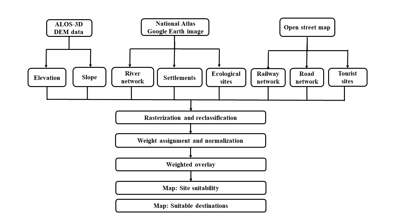
A survey of relevant literature on ecotourism, tourist activities and related aspects was also taken into account for the research. Based on previous studies on potentiality of tourism sites with available information and suggestion from tourism experts, extensive experience in the local area, as well as perceptions gained via field surveys in the Purulia district eight priorities of factors, such as elevation (C1), slope (C2) proximity to river area (C3), distance from road (C4), distance from settlement patches (C5), distance from ecological sites(C6), distance from railway track (C7) distance from existing tourism sites (C8) are taken as a criterion for determining potential ecotourism suitable zones of Purulia District.
For mapping the elevation, DEM data with 30- meters resolution ALOS World-3D was downloaded from JAXA’s global ALOS portal (https://www.eorc.jaxa.jp/ALOS/en/aw3d30).
Mosaicking and subset functions were performed to delineate the area of interest (AOI) using ArcGIS software. After geometric and atmospheric correction of image raster map of elevation was derived from DEM data using ARC-GIS 10.6.1. The rivers and settlement patches are digitized from Google Earth image. Road, tourist sites, ecological sites and railway datasets were downloaded from open street mapping. All the criteria are categorized into five suitability classes according to index values, highly suitable (S1), moderately suitable (S2), suitable (S3), less suitable (S4) and unsuitable (S5). After adopting the AHP approach to determine weights for each criterion and sub-criterion, all of the criterion maps are combined together with the help of a weightage linear combination in order to determine potential areas for ecotourism development. After that six alternative tourism destinations were depicted from first two suitability class (S1 and S2) to rank the best alternative tourist destination according to the tourist point of view (Table 2).
3.2 Criteria
Numerous factors, including natural attractions, topographical variation, climatic decency, rainfall, overall cleanliness of the place, cuisine, shopping, transportation and the quality of hotels and restaurants are considered when determining whether or not an area is suitable for ecotourism. For this study, fourteen criteria are initially selected based on previous literature of study area and consider physical, socio-economic, and cultural set up of Purulia district but finally, according to the local stakeholders’ and experts’ preferences, eight factors are found more relevant in this study area for exploring the potentiality of ecotourism. Following is a discussion on selected criteria and how they affect the growth of ecotourism.
Table 3. Criteria, sub-criteria, ranking, weights and influence
|
Criteria
|
Sub-criteria
|
Area in
(km2)
|
Suitability
ranking
|
Suitability
levels
|
Sub-criteria
weights
|
Influence (%)
|
|
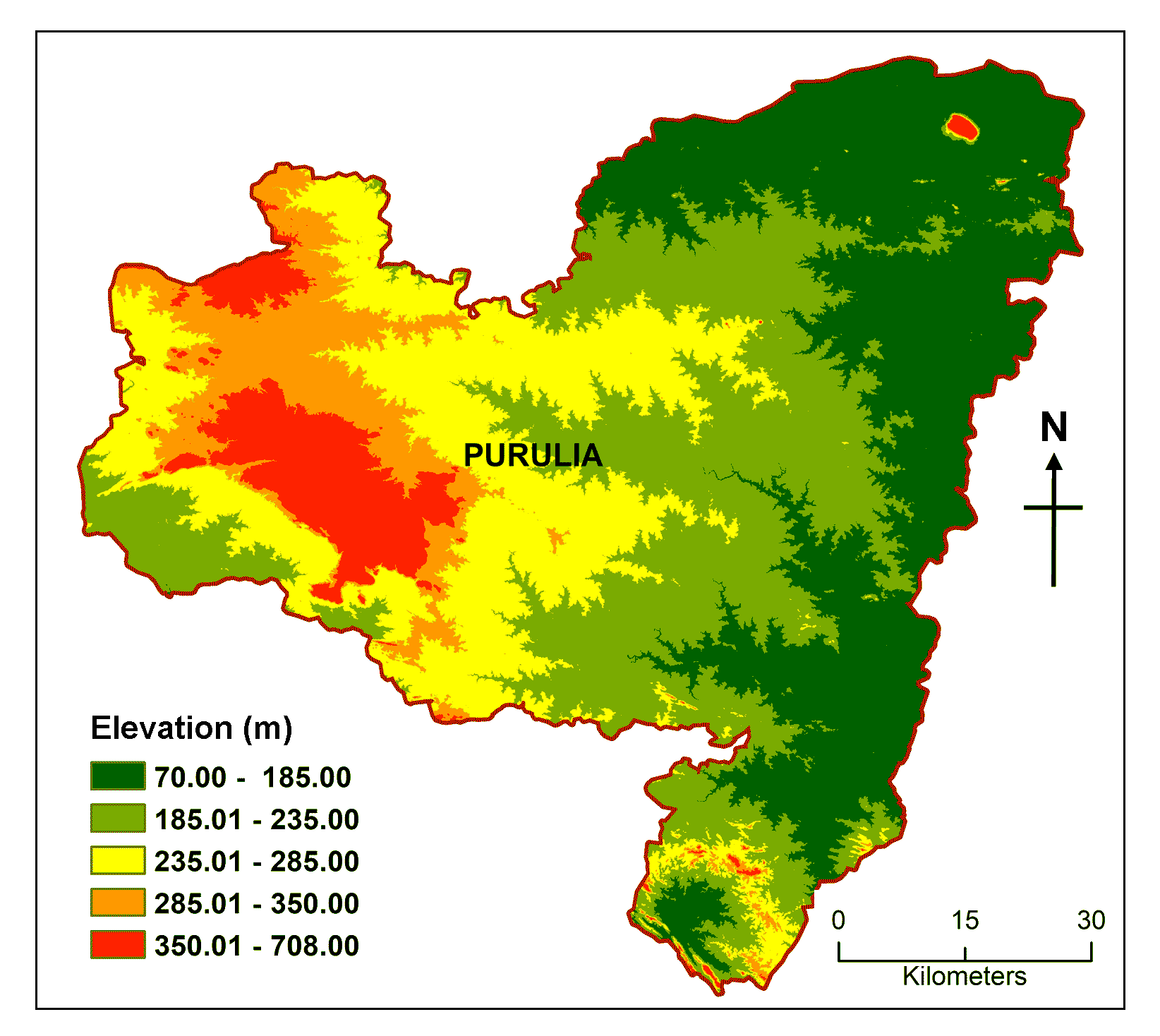
Elevation (m) (C1)
|
70.00-185.00
|
1776.43
|
1
|
Unsuitable
|
0.04
|
17.47
|
|
185.00-235.00
|
1834.96
|
2
|
Less suitable
|
0.08
|
|
235.00-285.00
|
1826.89
|
3
|
Suitable
|
0.14
|
|
285.00-350.00
|
576.59
|
4
|
Moderately suitable
|
0.27
|
|
350.00-708.00
|
244.13
|
5
|
Highly suitable
|
0.47
|
|
Slope (º) (C2)
|
0-2.50
|
2972.542
|
1
|
Unsuitable
|
0.04
|
6.63
|
|
2.51-5.00
|
2112.808
|
2
|
Less suitable
|
0.07
|
|
5.01-10.00
|
519.1121
|
3
|
Suitable
|
0.09
|
|
10.00-20.00
|
345.7891
|
4
|
Moderately suitable
|
0.33
|
|
> 20.00
|
308.756
|
5
|
Highly suitable
|
0.47
|
|
Proximity to rivers (m) (C3)
|
<500
|
331.38
|
5
|
Highly suitable
|
0.51
|
2.56
|
|
500-1000
|
341.55
|
4
|
Moderately suitable
|
0.26
|
|
1000-2000
|
643.98
|
3
|
Suitable
|
0.13
|
|
2000-3000
|
627.06
|
2
|
Less suitable
|
0.06
|
|
3000-16500
|
4315.03
|
1
|
unsuitable
|
0.03
|
|
Distance from road (m) ( C4)
|
< 250
|
591.30
|
5
|
Highly suitable
|
0.42
|
5.57
|
|
250-500
|
521.10
|
4
|
Moderately suitable
|
0.26
|
|
500-750
|
461.03
|
3
|
Suitable
|
0.16
|
|
750-2000
|
912.56
|
2
|
Less suitable
|
0.10
|
|
2000-15400
|
3773.01
|
1
|
Unsuitable
|
0.06
|
|
Distance from Settlement (m)
(C5)
|
0.00-1000
|
549.23
|
5
|
Highly suitable
|
0.47
|
11.10
|
|
1000-2000
|
698.34
|
4
|
Moderately suitable
|
0.22
|
|
2000-3000
|
809.38
|
3
|
Suitable
|
0.14
|
|
3000.00-4000
|
1998.09
|
2
|
Less suitable
|
0.10
|
|
4000.00-11050
|
2753.19
|
1
|
Unsuitable
|
0.07
|
|
Distance from ecological sites
(m) (C6)
|
0-1000
|
921.22
|
5
|
Highly suitable
|
0.54
|
20.20
|
|
1000-3000
|
1298.09
|
4
|
Moderately suitable
|
0.26
|
|
3000-5000
|
1143.7
|
3
|
Suitable
|
0.12
|
|
5000-7000
|
952.76
|
2
|
Less suitable
|
0.06
|
|
7000-23000
|
1943.23
|
1
|
Unsuitable
|
0.03
|
|
Distance from railway track (m) (C7)
|
<1500
|
672.98
|
5
|
Highly suitable
|
0.38
|
9.69
|
|
1500-3000
|
580.97
|
4
|
Moderately suitable
|
0.26
|
|
3000-4500
|
500.98
|
3
|
Suitable
|
0.18
|
|
4500-6000
|
434.09
|
2
|
Less suitable
|
0.11
|
|
6000-52000
|
4069.98
|
1
|
Unsuitable
|
0.06
|
|
Distance from tourism center (m) (C8)
|
0.00-2000
|
475.68
|
5
|
Highly suitable
|
0.53
|
26.78%
|
|
2000-4000
|
492.98
|
4
|
Moderately suitable
|
0.26
|
|
4000-6000
|
512.35
|
3
|
Suitable
|
0.12
|
|
6000-8000
|
562.46
|
2
|
Less suitable
|
0.06
|
|
8000-25000
|
4215.53
|
1
|
Unsuitable
|
0.03
|
3.2.1 Elevation (C1)
High elevation always enhancing the degree of landscape attractiveness which draw tourists because of the stunning natural beauty, many recreational opportunities and extensive cultural history. The vertical relief creates diverse attractiveness, unique biodiversity with natural vegetation and native wildlife considering temperature and climatic variation (Ahmadi et al., 2015; Bunruamkaew et al., 2012; Foggin, 2016; Kumari et al., 2010). Those locations that are blessed with significant differences in altitude, tourists can enjoy a magnificent vista of the valley, the grassland, and any other picturesque attractions further downstream. Present study area Purulia district, enriched with undulating land with scattered hills like Joychandi Pahar, Panchet hill and Ajodhya hills which is easternmost part of Chhotanagpur plateau and extended portion of Eastern Ghats range. The elevation map was depicted from DEM data segmented into five classes and weights were given based on attractiveness of the landscape where higher elevation consider being more suitable. The entire area has been divided into four categories based on elevation: 70-185m, 185-235m, 235-285m and 285-350m, respectively (Table 3; Figure 3A).
3.2.2 Slope (C2)
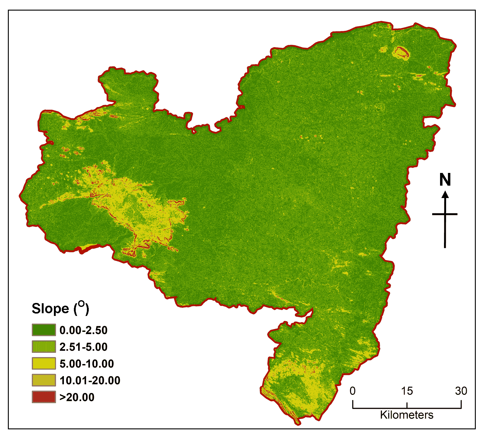
The degree of slope determines topographical steepness and curvature in an area where slope inclination can be retrieved directly from DEM data. Slope profile gives the impression of having a visually appealing appearance to spectators across a greater geographical area. Owing to its attraction slope is regarded as an important criterion factor in the evaluation of a location’s viability for ecotourism. Higher slopes are better for the expansion of ecotourism since they are more attractive but excessively steep slopes could impede tourism growth owing to transportation challenges (Sahani, 2019; Bunruamkaew and Murayama, 2012; Kumari et al., 2010). The completely flat region has very little chances of dense vegetation cover and wildlife, whereas the hilly and mountainous terrain offers the best possibilities for nature-based tourism. After computing the slope degree from the DEM data, it was further reclassified into the appropriate class based on suitability for ecotourism. Therefore, slope map divided into following segments 0.00-2.50° (unsuitable), 2.50-5.00° (less suitable), 5.00-10.00° (suitable), 10.00-20.00° (moderately suitable) and >20.0° (highly suitable) (Table 3; Figure 3B).
3.2.3 Proximity to Rivers (C3)
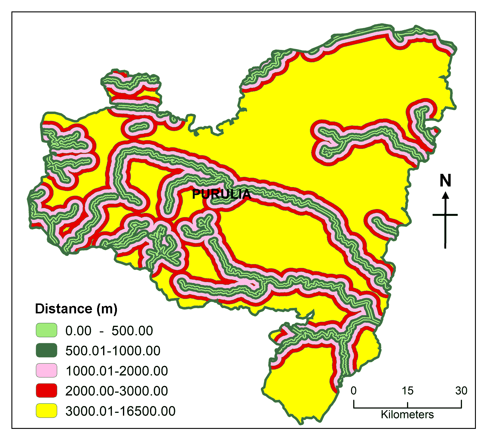
Rivers and riverfronts are possible destinations for water sports including rafting, kayaking, swimming and bird observation. They also provide a sense of heritage and adventure as well as links with the environment and natural world and can be developed to create tourist attractions (Prideaux and Cooper, 2009). The river was considered in evaluating the suitability of the ecotourism location for the aforementioned reason. Rivers such as Kangsabati, Kumari, Silabati, Dwarakeswar, Subarnarekha and Damodar are flowing across Purulia district. Following the preparation of maps depicting the network of streams and the computation of distances, the areas that are geographically closest to the rivers have been assigned the highest rating. Based on the distance from various river network, this district has been divided up into five different suitability zones such as highly suitable (<500m), moderately suitable (500-1000m), suitable (1000-1500m) and less suitable (1500-2000m) and unsuitable (2000-2500m) (Table 3; Figure 3C).
3.2.4 Distance from Road (C4)
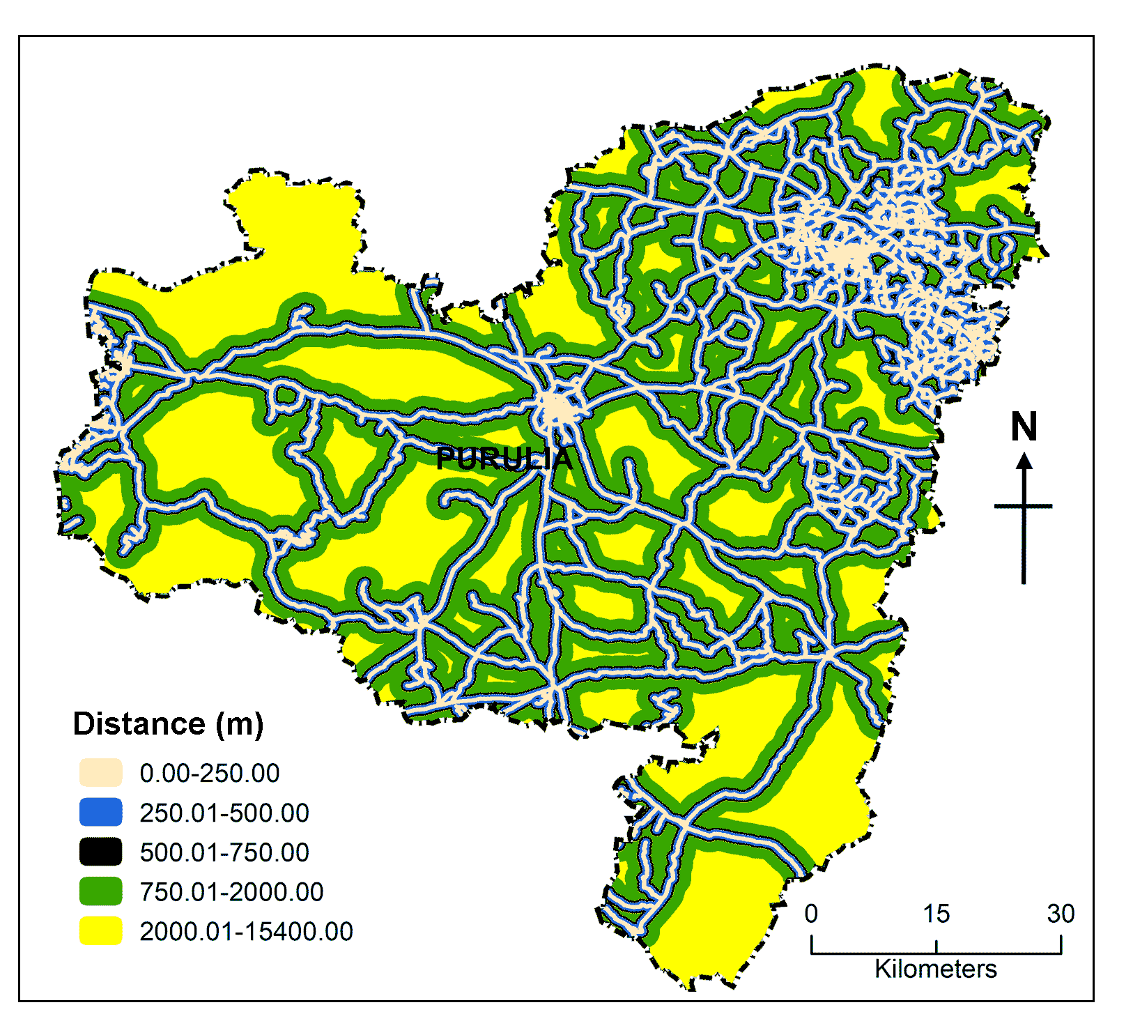
Accessibility is a precondition for the growth of ecotourism, for engaging in tourism related activities, there must be adequate connectivity between the point of origin and the tourist attraction. Comfortable and secure road access to the desired ecotourism destination boosts visitor possibilities (Chandio et al., 2013; Istomina et al., 2016). In any steep hills, the highways are viewed as the main business and tourist routes, this system establishes the connections between the locations, outdoor activities and lodging. Rugged terrain and sloppy ground make it difficult to build other modes of transportation where road networks can be a convenient means of transport (Taye et al., 2019). Many potential ecotourism destinations such as deep forests, waterfalls, lofty hills and historical and archaeological sites may remain unexplored if there is insufficient or poor connectivity. As ecotourism activities located far away from road access are unsuitable for ecotourism development that’s why areas nearest to the road were given the highest grade. For the identification of ecotourism sites, five zones of 250m, 250-500m, 500-750m, 750-2000m and 2000-15400m from the road network have been prepared (Table 3; Figure 3D).
3.2.5 Distance from Settlements (C5)
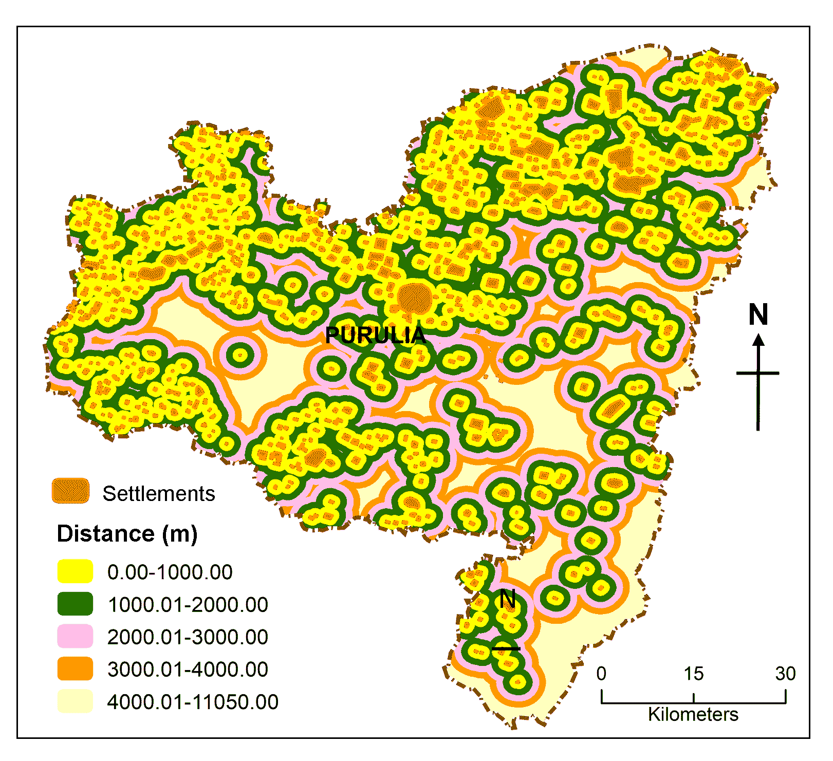
Although locations that are away from the hustle and bustle of cities tend to be more appealing to tourists being in close proximity to a city ensures that visitors have access to essential public services and amenities, like lodging, transit, food and shopping centers, banks, and ATMs (Tanjung and Hutagaol, 2019). Ecotourists essentially desire to stay in locations where it is possible to engage in cultural interactions with locals, that’s why there’s a good correlation between human settlement and ecotourism growth. There are just a few minor towns with greener environs in the study region at the moment, the largest of which being Purulia town (1.21 lakh people), followed by Raghunathpur (25561), Balarampur (24431), Jhalda (19544), Baghmundi (4035) and other census towns. Distance from the settlement areas were mapped and classified it into five categories highly suitable (0-1000m), moderately suitable (1000-2000m), suitable (2000-3000m), less suitable (3000-4000m) and unsuitable (4000-11050m) areas, respectively (Table 3; Figure 3E).
3.2.6 Distance from Ecological Sites (C6)
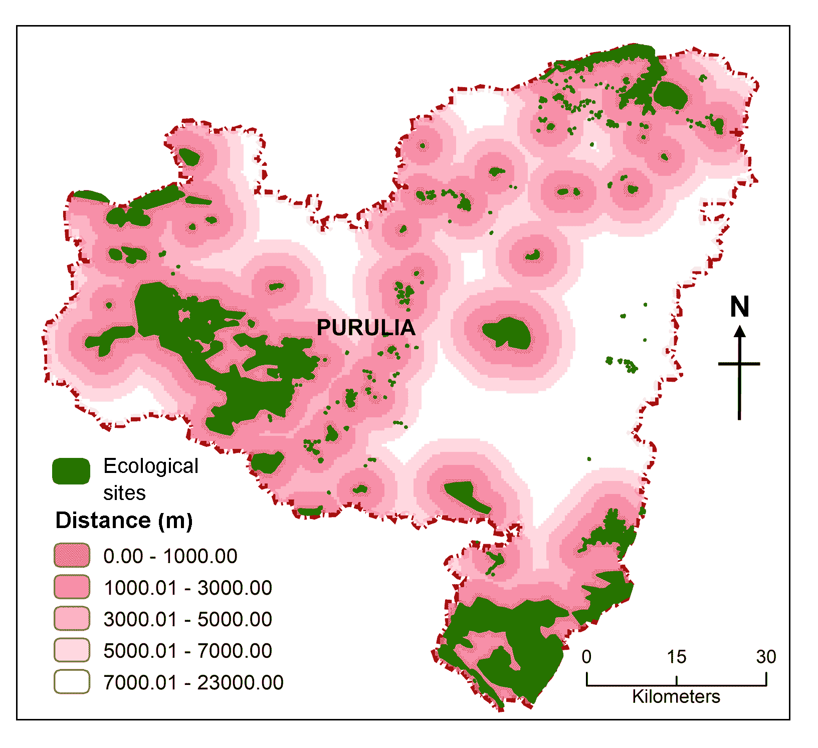
It has been found that landscape naturalness and ecotourism attractions, specifically scenic appeal and vegetation cover, have a favorable association with one another (Roque et al., 2020; Cetin and Sevik, 2016). The lush green forested panorama usually offers pleasure to the human mind increases our desire for travelling. Tracking through dense forests cover always thrilled the tourists by its beauty of natural landscape. In the Purulia district, lots of eco-park, eco-sites, nature-based tourism sites, mountaineering sites and climbing sites are established to encourage nature lover, Gorgaburu Eco-resort, Palash Bitan Jungle Hut at Murguma, and Eco-Adventure Resort at Khairabera are examples of ecotourism development. This region is covered with thickly forested ranges like as Balarampur, Bagmundi, Ajoydhya, Arsha, and Jhalda. After preparing a map of forest cover and ecotourism sites, priority was given to those areas which are nearer to ecological sites. Distances were calculated from those ecological sites and classified into five namely 0-1000m (highly suitable), 1000-3000m (moderately suitable), 3000-5000m (suitable), 5000-7000m (less suitable) and 7000-23000m (unsuitable) for tourism perspective (Table 3; Figure 3F).
3.2.7 Distance from Railway Track (C7)
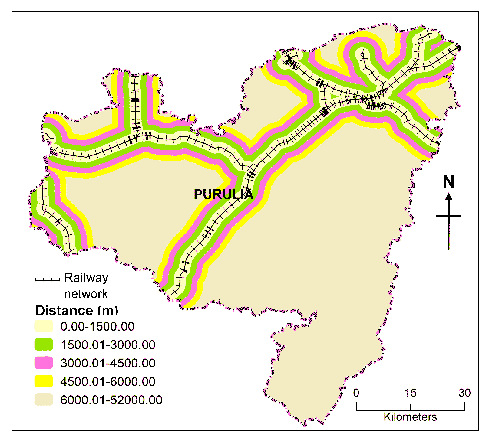
There is no commercial airport in this district so only way to reach this area from other parts of India through railways and roadway. It provides connectivity between tourism spots and other cities of India. Rail connectivity is not only more affordable than other forms of communication but also safer and faster. Areas that are connected to the railway network and road network have a better chance of expanding into larger tourist hubs.
Railway has an important role in Purulia district for the development of ecotourism there was three major railway stations which connected with this tourism sites with other parts of the country. Purulia, Asansol, Adra junction are the major railway junction in this area. Distance from the railway track were mapped and sub-divided into five distinct categories 0-1500m, 1500-3000m, 3000-4500m, 4500-6000m and 6000-5200m (Table 3; Figure 3G)
3.2.8 Distance from Tourism Center (C8)
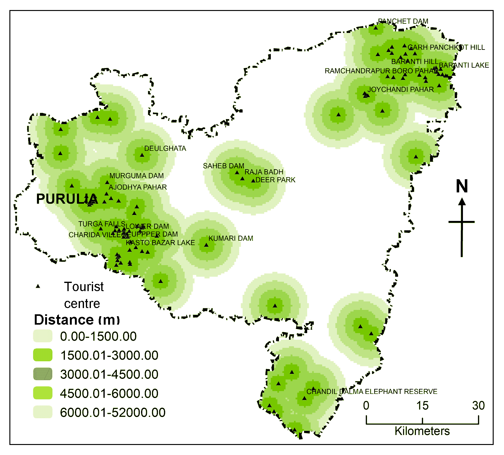
Because already established tourist destinations have the essential infrastructure, including lodging, restaurants, shops, transportation, dining, shopping, banking and ATMs, they are advantageous for continued tourism growth and economic development. Furthermore, building tourism infrastructure like hotels and highways would be expensive for the government and commercial developers, thus locations closer to already established tourist destinations are given more weight. Purulia district there are several hills and small mounds, the important ones are Ayodhya hills, Joychandi hill, Panchkot hill as well as other popular tourist destinations baranti lake, Garpanchkot. Waterfalls like Machkanda falls and Bamni falls, the artists village Charida (renowned for its chhau mask) are popular for tourism point of view. Distance from present tourism sites are mapped and classified into five categories: 0-2000m, 2000-4000m, 4000-6000m, 6000-8000m, 8000-25000m (Table 3; Figure 3H).
3.3 Generation of Criteria and Sub-criteria and their Respective Weights
As already discussed criteria were selected from previous literature and expert guidance for suitability mapping of ecotourism sites after screening finally eight criteria were found most detrimental which influence the suitability of tourism sites in present study area Purulia district. Now criteria weights are assigned based on their relative importance to each criterion to other criteria. Ratings for sub-criteria within a set of criteria demonstrate the relative importance of each sub-criteria than other sub-criteria to satisfy the desirable
condition for suitability of land use for a particular purpose. Then each criterion was segmented divided into five sub-criteria and ranked in terms of how well it would promote to the expansion of ecotourism, such as (i) highly suitable (criteria weights = 5), (ii) moderately suitable (criteria weights = 4) (iii) suitable (criteria weights = 3), (iv) less suitable (criteria weights = 2) and (v) unsuitable (criteria weights = 1). For sub-criteria weights each sub-criterion were compared in 5 X 5 pairwise matrix tables and weights are assigned based on their suitability for each ecotourism development in AHP methods (Hanine et al., 2016). Spatial data set were created using each criteria and sub-criteria, generally all those dataset which are in vectors format- points (urban area, tourism sites), lines (river, railway and road) and polygon (ecological sites) converted to raster format by the process of rasterization. Euclidean distance, proximity analysis, multiple buffer were performed for each criterion based on land suitability for ecotourism. All the layer is prepared, classified and reclassify in Arc-GIS 10.6.1 software. For preparation of elevation map, required data was retrieved from DAICHI-2 satellite and classified the raster layer according to their suitability for ecotourism (Table 3).
3.4 Analytical Hierarchical Process (AHP)
AHP was initially devised by Thomas Saaty in 1980, and it serves as a productive tool when dealing with complicated decision problems by adopting pairwise comparison matrices (Saaty et al., 2001; Saaty, 2008; Parry et al., 2018). It leverages hierarchical structures by establishing priorities for many alternatives based on the decision makers’ preferences, which allows it to solve complicated problems and propose answers to those difficulties (Brushan and Rai, 2004). In the present investigation, the AHP was utilized to determine the relevance of the weightings assigned to the chosen criterion by employing a matrix of pairwise comparisons (Chabuk et al., 2019). In general, AHP operates by establishing priorities for various options and criteria that are applied to the assessment of those alternatives based on Saaty’s scale values (Saaty et al., 2001). This comparisons emphasis on how important each of the two factors is in assessing if something is a good fit for the stated purpose. Consequently, a pairwise comparison matrix is constructed to compare all of the factors. Accordingly, Saaty (2008) suggested scale, rating scale values ranging from 1 to 9 points to express individual preferences or judgments, criteria weights one denotes that both criteria are equally important, but criteria weights nine signify that one criterion has overwhelming superiority over the other (Zhang et al., 2009). The relative importance of each aspect was determined by the local experience in the field as well as the opinions of the experts. In this study eight most detrimental criteria are compared and weights were given in AHP method and finally summed up using a weighted linear combination to get desired suitability maps (Table 4).
Table 4. Relative importance (Saaty, 1980)
|
Intensity of importance
|
Numerical rating
|
Reciprocal
|
Explanation
|
|
1
|
Equal importance
|
1
|
Both the criteria are contributing equally important to the activities
|
|
3
|
Moderate importance
|
1/3
|
One criterion is slightly favor over another to the activity concerned
|
|
5
|
Strong importance
|
1/5
|
Criteria Judgment strongly favor one criterion than over another for activity concern
|
|
7
|
Very strong or demonstrated
|
1/7
|
An criteria judgment is favored very strongly over another for activity concern
|
|
9
|
Extreme importance
|
1/9
|
The evidence favoring one criteria over another is of the highest possible order of affirmation
|
|
2, 4, 6, 8
|
Intermediate values between the two adjacent judgments
|
1/2, 1/4, 1/6, 1/8
|
When compromise is needed
|
|
Reciprocals (Opposites): Used for inverse comparison
|
3.5 Calculation Procedure for AHP
Step-1: Suitable criteria are derived from previous literature, expert views and keeping geophysical conditions in mind for potential ecotourism sites selection. After consulting with relevant experts in the field of ecotourism including government officials, entrepreneurs, researchers and geologists, criteria weights and sub-criteria rating for each criterion were then determined.
Step-2: With the purposes of comparison each criteria a pairwise comparison matrix needs to constructed:
\(C_{ij}= \begin{bmatrix} C_{11} & C_{12} & \cdots & C_{1n} \\ C_{21} & C_{22} & \cdots & C_{2n} \\ C_{1n} & C_{2n} & \cdots & C_{nn} \\ \end{bmatrix}\) (1)
where, C11 represent criteria score of row ith (the first row) and column jth (the first column) in the pairwise comparison matrix. Reciprocity property of the matrix mathematically stated as:
\(C_{ij} = {1 \over C_{ij}}\) (2)
Step-3: Then, values of each column in pairwise comparison matrix are summed up for normalization purposes, which can be expressed as follows:
\(C_{ij} = \sum^n_{i=1} C_{ij}\) (3)
Step-4: Normalizing the pairwise comparison matrix- each column values need to divide by its column total to develop a normalized pare wise matrix based on the following equation:
\(C_{ij}= {C{ij} \over \sum^n_{i=1} C{ij}} \begin{bmatrix} X_{11} & X_{12} & X_{13} \\ X_{21} & X_{22} & X_{23} \\ X_{31} & X_{32} & X_{33} \\ \end{bmatrix}\) (4)
Step-5: Weightage matrix- then, divide the sum of the column of normalized column of the matrix by the number of criteria used (n) to generates a weighted matrix. The following equation computes the weight for each criterion:
\(C_{ij}= {\sum^n_{i=1} C{ij} \over n} \begin{bmatrix} W_{11} \\ W_{12} \\ W_{1n} \\ \end{bmatrix}\) (5)
Step-6A: Consistency analysis- consistency vectors are calculated by multiplying a pairwise matrix by a weighted vector.
\( \begin{bmatrix} C_{11} & C_{12} & \cdots & C_{1n} \\ C_{21} & C_{22} & \cdots & C_{2n} \\ C_{1n} & C_{2n} & \cdots & C_{nn} \\ \end{bmatrix} \times \begin{bmatrix} W_{11} \\ W_{12} \\ W_{1n} \\ \end{bmatrix} = \begin{bmatrix} Cv_{11} \\ Cv_{21} \\ Cv_{1n} \\ \end{bmatrix}\) (6)
Step-6B: Then, it is accomplished by dividing the weighted sum vector with criterion weights:
\(Cv_{11} = {1 \over W_{11}} [C_{11} W_{11} + C_{12}W_{21} + C_{13}W_{31} ]\) (7)
\(Cv_{21} = {1 \over W_{21}} [C_{21} W_{11} + C_{22}W_{21} + C_{23}W_{31} ]\)
\(Cv_{31} = {1 \over W_{31}} [C_{31} W_{11} + C_{32}W_{21} + C_{33}W_{31} ]\)
Step-6C: Mean of normalized values (Lambda max method)- calculating by averaging value of consistency vectors:
\(\lambda max = \sum^n_{i=1} Cv_{ij}\) (8)
Step-7: Check the consistency- the AHP method enables us to assess the consistency of the criteria weights in order to detect and minimize contradictions in viewpoints. To check consistency Saaty suggested two index, consistency ratio (CR) and consistency index (CI) and finally compare with random index (RI) table.
Step-7A: Consistency ratio (CI)- Han and Tsay (1998) suggested following equation to measure how far a matrix is deviated from consistency.
\(CI= {\lambda max -2 \over n-1}\) (9)
where, n is the number of criteria and λ max is the biggest eigenvalue.
\(CI= {8.3152-8 \over 8-1} = 0.0394\)
Step-7B: The consistency ratio (CR)- by comparing the CI values with the tabulated RI score, the consistency ratio is ultimately obtained (Malczewski, 2005), here (RI = 1.40), where, n is the matrix size (n = 8). Table 5 shows RI value with different criteria value.
\(CR= {CI \over RI}\) (10)
\(CR= {0.0394 \over 1.40} = 0.0281\)
Table 5. Random index
|
n
|
1
|
2
|
3
|
4
|
5
|
6
|
7
|
8
|
9
|
10
|
11
|
12
|
13
|
14
|
15
|
|
RI
|
0.00
|
0.00
|
0.52
|
0.89
|
1.11
|
1.25
|
1.35
|
1.40
|
1.45
|
1.49
|
1.51
|
1.54
|
1.56
|
1.57
|
1.58
|
n = order of matrix
If consistency ratio (CR) value was less than 0.10, it should be acceptable for further analysis in AHP If it was found that CR was greater than 0.10, it was recommended that to revise the judgmental matrix to counter inconsistency in judgment (Table 6A and B).
Table 6A. Pairwise comparison matrix and criteria weights
|
Criteria
|
Elevation (C1)
|
Slope (C2)
|
River (C3)
|
Road (C4)
|
Settlement (C5)
|
Ecological sites (C6)
|
Railway
track (C7)
|
Tourism centers (C8)
|
|
Elevation (C1)
|
1
|
4
|
6
|
4
|
2
|
0.5
|
2
|
0.5
|
|
Slope (C2)
|
0.25
|
1
|
3
|
2
|
0.5
|
0.25
|
0.5
|
0.33
|
|
River (C3)
|
0.16
|
0.33
|
1
|
0.33
|
0.25
|
0.2
|
0.2
|
0.11
|
|
Road (C4)
|
0.25
|
0.5
|
3
|
1
|
0.5
|
0.25
|
0.5
|
0.33
|
|
Settlement (C5)
|
0.5
|
2
|
4
|
2
|
1
|
0.5
|
2
|
0.33
|
|
Ecological sites (C6)
|
2
|
4
|
5
|
4
|
2
|
1
|
2
|
0.5
|
|
Railway track (C7)
|
0.5
|
2
|
5
|
2
|
0.5
|
0.5
|
1
|
0.33
|
|
Tourism center (C8)
|
2
|
3
|
9
|
3
|
3
|
2
|
3
|
1
|
|
Total
|
6.66
|
16.83
|
36
|
18.33
|
9.75
|
5.2
|
11.2
|
3.44
|
Table 6B. Normalized weight matrix for AHP
|
Criteria
|
C1
|
C2
|
C3
|
C4
|
C5
|
C6
|
C7
|
C8
|
Weighted sum
|
Criteria weights
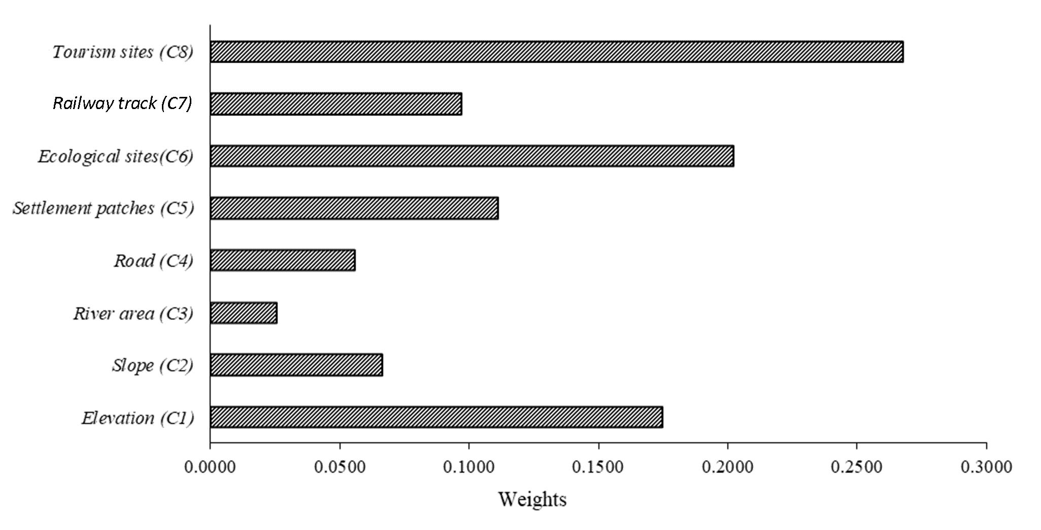
|
Consistency analysis
|
Ranks
|
|
C1
|
0.15
|
0.238
|
0.167
|
0.218
|
0.205
|
0.096
|
0.179
|
0.145
|
1.398
|
0.175
|
8.398
|
3
|
|
C2
|
0.037
|
0.059
|
0.083
|
0.109
|
0.051
|
0.048
|
0.045
|
0.097
|
0.53
|
0.066
|
8.1786
|
6
|
|
C3
|
0.025
|
0.02
|
0.028
|
0.018
|
0.026
|
0.038
|
0.018
|
0.032
|
0.205
|
0.026
|
8.3006
|
8
|
|
C4
|
0.037
|
0.03
|
0.083
|
0.055
|
0.051
|
0.048
|
0.045
|
0.097
|
0.446
|
0.056
|
8.1297
|
7
|
|
C5
|
0.075
|
0.119
|
0.111
|
0.109
|
0.103
|
0.096
|
0.179
|
0.097
|
0.888
|
0.111
|
8.3673
|
4
|
|
C6
|
0.3
|
0.238
|
0.139
|
0.218
|
0.205
|
0.192
|
0.179
|
0.145
|
1.616
|
0.202
|
8.5011
|
2
|
|
C7
|
0.075
|
0.119
|
0.139
|
0.109
|
0.051
|
0.096
|
0.089
|
0.097
|
0.775
|
0.097
|
8.2763
|
5
|
|
C8
|
0.3
|
0.178
|
0.25
|
0.164
|
0.308
|
0.385
|
0.268
|
0.29
|
2.142
|
0.268
|
8.3697
|
1
|
|
Total
|
1
|
1
|
1
|
1
|
1
|
1
|
1
|
1
|
|
1
|
8.3152
|
|
3.6 Standardization of Criterion
All the parameters used as criteria for suitability mapping of ecotourism development are in different statistical units, reflecting different degree of compatibility with the possibility for ecotourism (Effat and Hassan, 2013). In AHP method, all the selected criteria have to standardize to integrate it in weighted linear combination to identify potential ecotourism zone. AHP enables to incorporate all the qualitative and quantitative parameters. Standardization makes all the spatial layer unitless and make it easy to integrate (Pereira and Duckstein, 1993; Mansour et al., 2019). As rater format are easily integrated than the vectors format, so all the criteria converted into vectors format and reclassify in Arc-GIS.
3.7 Ecotourism Potential Priority Index (EPPI) using Weighting Linear Combination Approach
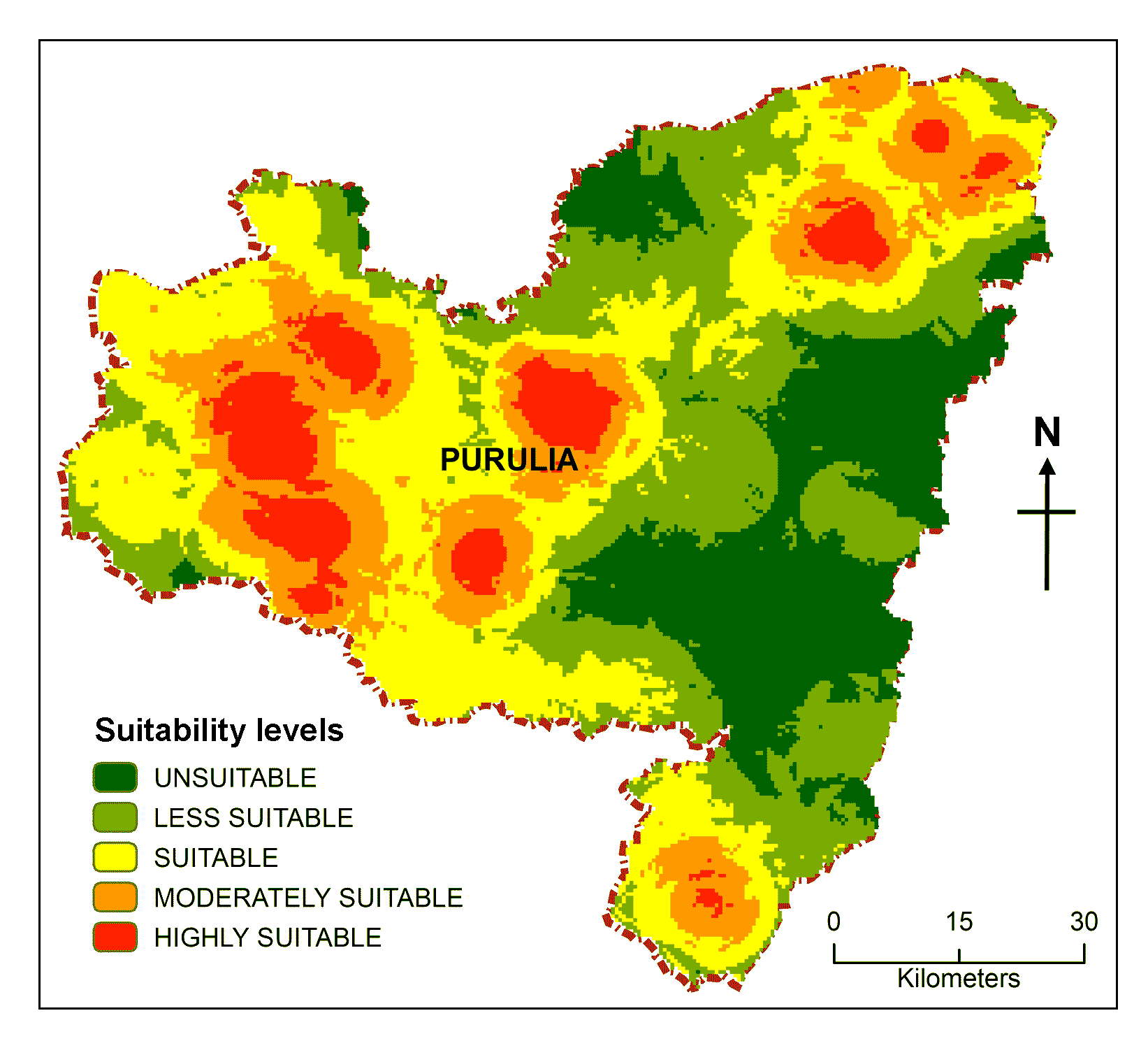
Ecotourism Potential Priority Index (EPPI) which is basically unitless spatial method use here for the delineation of ecotourism potential zone in Purulia district. All those criteria are integrated in weighted linear combination technique to get ecotourism potential map (Malczewski, 2006). In this stage, weighted overlay technique was performed to combine all weighted spatial layers and produce the ecotourism potential zone using Arc-GIS 10.6.1 (Suryabhagavan, 2015). To obtain the EPPI value for the potential areas, all these criteria map and their respective weights are summed up in Weight Linear Combination (WLC), the combined sum would be final ecotourism suitability map using the equation (Figure 4):
\(EPPI = \sum^n_{i=1} W_i \times C_{ij}\) (11)
where, EPPI represent Ecotourism Potentiality Priority Index, Wi: weights of selected criterion i, Cij: Reclassified criteria map and n denotes total number of criteria.
5 . DISCUSSION
To preserve the environment, guarantee of the local population’s livelihood is essential, especially in isolated areas with insufficient government support; in these circumstances, ecotourism development may create additional opportunities for income generation. This research attempts to address an integrated approach for ecotourism suitability coupled up GIS with AHP after matching suitable criteria identifies most desirable area for ecotourism. Here, in this portion important eight criteria which have been selected discuss its relevance for exploring tourism potential.
1) Elevation (C1)
Higher elevation always attracts tourists for its clean, green lush environment, fresh air and panoranic view of the mountain (Ariza et al., 2013). The most alluring features of Purulia tourism evolved around this verdant, hilly landscape with a dense forest cover which mesmerizes city dwellers.
2) Slope (C2)
The slope of the land is extremely important to creating a prospective ecotourism site. The choices were assigned based on the relative relevance of each class and a greater slope value suggests a better likelihood of developing a potential ecotourism site and vice versa (Dashti et al., 2013).
3) Proximity to river (C3)
Picturesque river landscape always mesmerizing hearts of tourist by its riparian forest along the river, swampy vegetation, wetland, lake and spring near to the ecotourism sites are preferable which attracts more tourists to that area (Fachrudin et al., 2016). As there is scarcity of water due to location of barren land Chotanagpur plateau that’s why people are mainly concentrated on river areas which help to develop tourism.
4) Distance from road (C4)
The traveler always prefers easy access to the tourist attractions via a convenient transportation system when travelling (Kim et al., 2011). Some of the areas also in this district remained untapped due to poor transportation.
5) Distance from settlements (C5)
Urban areas or human habitation made it easier for tourists to fulfill their fundamental requirements while engaging in ecotourism activities, which is why sites close to populated regions are given more weight than those farther away.
6) Distance from ecological sites (C6)
Visitors are attracted to a place to participate for ecotourism for a number of different reasons, including the natural, cultural and geophysical characteristics of the location. Biotic properties, such as biodiversity, wildlife and ecological regions are regarded as the most crucial factor in the creation of ecotourism sites. Forest based ecotourism approach always helps preserve forest ecology and positively impact the economy and environment of the host area and benefit local communities for their earing. In this district, recent development of tourism helped the local people for earning their daily wages.
7) Distance from railway tracks (C7)
Eastern and southeastern, southwestern part of this district don’t have any railway connectivity and tourism potentiality yet to be explored.
8) Distance from tourism sites (C8)
The development of additional tourist destinations close to popular ones will draw more visitors to the region and encourage private investor and local administrator to investigate the viability of developing new sites based on existing infrastructure.
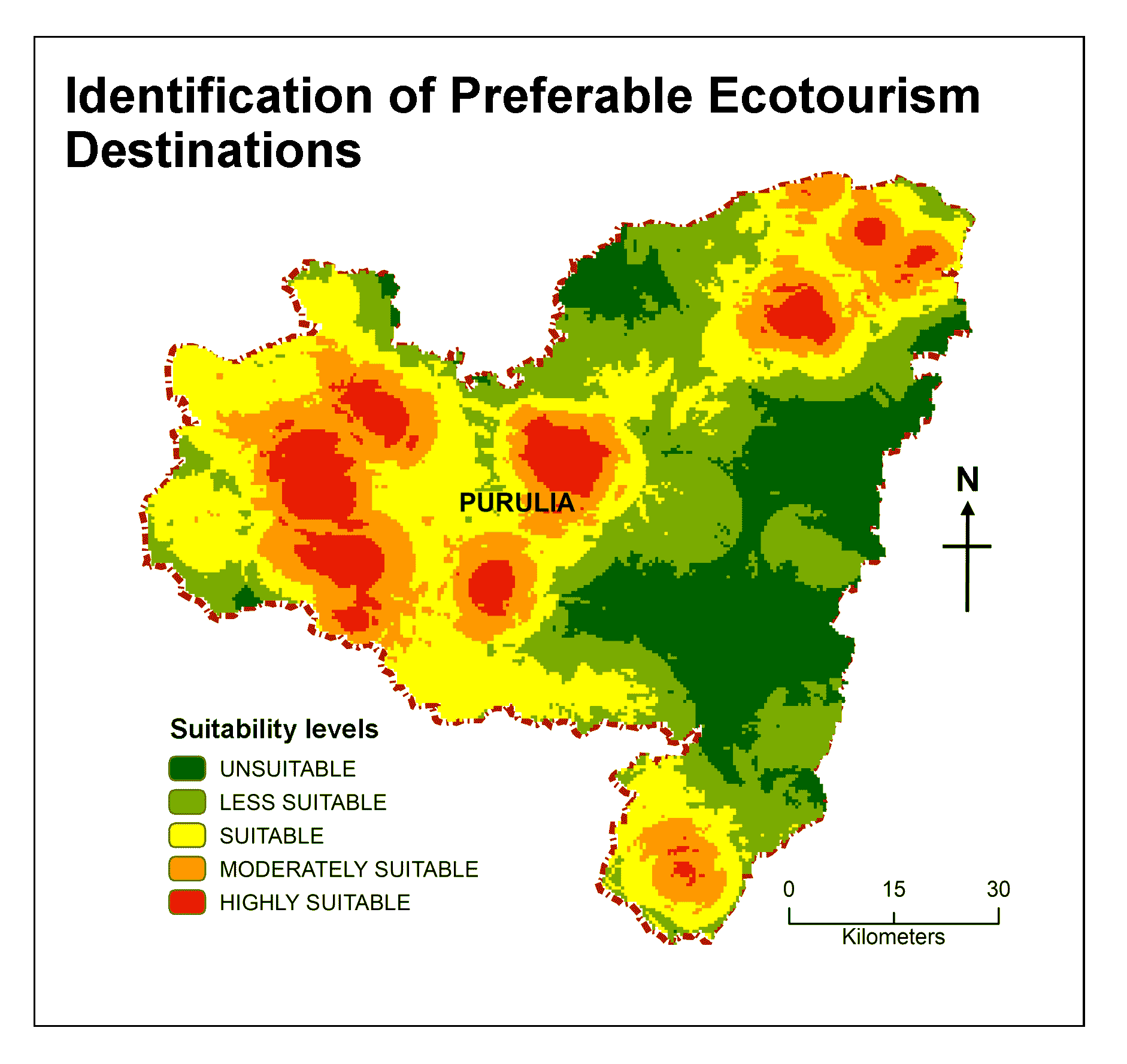
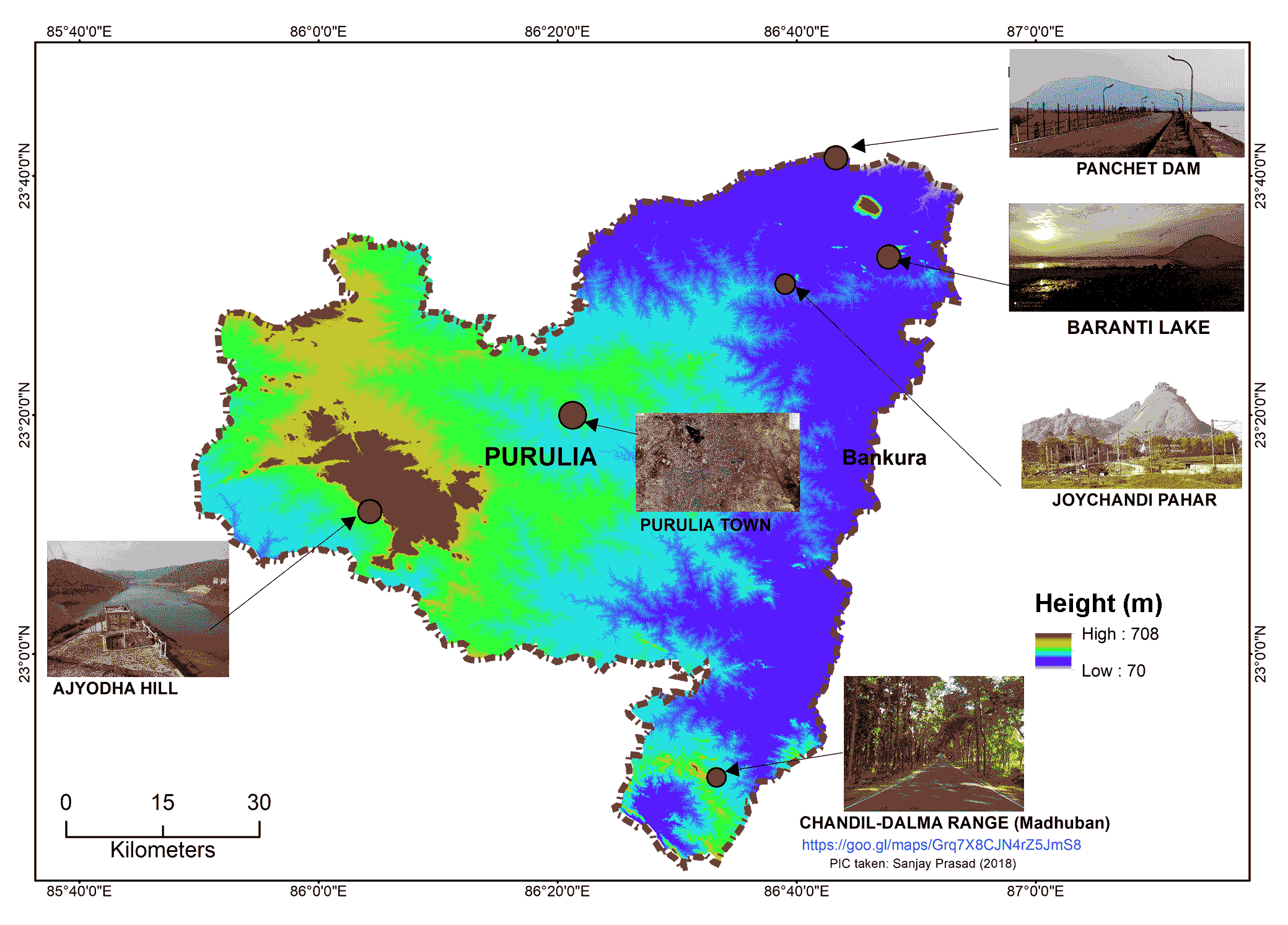
It would be a challenging task for the traveler to select a place of destination among various alternatives based on tourists’ preferences. Multi-criteria decision-making techniques (MCDM) can solve suitable site selection problems after comparing various alternatives that give the best option according to tourist preferences. employing AHP approach, possible ecotourism locations in the Purulia district were mapped for site suitability. Finally, six alternative tourist destinations were identified based on this suitability map of ecotourism and field verification through a personal visit for further investigation form the perspective of visitor choice. These alternative ecotourism sites are: Purulia town (A1), Ajodhya Hill and Forest area (A2), Raghunathpur-Joychandi Pahar (A3), Baranti hill and lake(A4), Garh Panchkot and Panchet dam (A5), Chandil Dalma elephant corridor (A6) (Figure 6). A total of 120 participants are chosen, 20 for each destination, including tourists, hotel managers, owners of local businesses and professionals in charge of managing tourism related activities. Through in-depth interviews, we are learning how visitors rank this tourism spot in terms of traveler security, natural views, accessibility, and lodging. A primary survey (2021-2022) was carried out between December and March based on five characteristics that are pretty representative from the perspective of tourists: (i) Road connectivity, (ii) per day cost, (iii) hotel availability, (iv) scenic beauty and (v) tourist safety (Table 8).
Table 8. Preferential tourism sites in Purulia district
|
Alternative ecotourism sites
|
Scenic beauty
|
Connectivity
|
Expenses (INR)
|
Hotels availability
|
Tourist
safety
|
Remarks
|
|
Purulia town (A1):
The largest town in the Purulia district is well connected to the rest of India has affordable lodging, and has urban amenities, but lack of tourist attractions in close proximity to the main town.
|
Densely populated urban area lacking with physical attractiveness.
|
Excellent road and rail connectivity
|
Foods and lodging: INR 1000 person/day
|
Room charges: INR 1000-1500
|
Absolutely safe for tourist even at night.
|
People may prefer to stay near to other ecotourism spots in order to take advantage of the natural surroundings.
|
|
Ajodhya hill and forest (A2):
Most popular ecotourism destination of Purulia district enriched with diversified landscape and ecotourism spots likes Khairabera, Murguma, Gorgaburu. It is has popular place for basic rock climbing.
|
Excellent scenic beauty diversified natural landscape such as forest, hill area, lakes, dams, tribal dance (Bihu) and various ecotourism sites. Palash and Shimul flowers are in blossom at these places at the onset of spring.
|
Good road
network with beautiful landscape
|
Foods and lodging: INR 1800 person/day
|
Room charges: INR 3000
|
Absolutely safe.
|
Very much popular among the tourists for ecotourism.
|
|
Raghunathpur-Joychandi Pahar (A3):
Popular tourist center and major attraction for rock climbing with good connectivity with rail and road, nearness to other tourism sites.
|
Lacking of physical attractiveness apart from joychandi hill but near to other tourism spots.
|
Excellent road and railway connectivity
|
Foods and lodging: INR 1250 person/day
|
Limited options.
Room charges: INR 1000-1800
|
Moreover safe for tourist.
|
Popular among rock climber but unpopular among tourist due to not much worth visiting.
|
|
Baranti hill and lake (A4):
A tribal village with dam (Muradi) and hill (Baranti), spectacular view of sunset and quiet ecotourism spots, nearness to other tourism spots like Biharinath and Garh Panchkot, costly accommodation and food.
|
Attractive lake and forest view with magnificent Palash flower in spring time. This baranti laking of attract migratory bird during winter months.
|
Good road and railway connectivity
|
Foods and lodging: INR 1550
person/day
|
Room charges: INR 1500-3500
Lots of resort and hotels.
|
Fell bit of unsafe in nighttime due to lack of streetlight.
|
Recently popular ecotourism destination among the tourist due to beautiful lake landscape.
|
|
Garh Panchkot and Panchet dam(A5):
Located in the eastern part of India at the foothills of Panchet Hill. awesome scenic beauty of forest, Panchet dam and historical significance ruined fort of Garh Panchkot.
|
Attractive landscape of Panchet dam between West Bengal and Jharkhand border.
|
Only road connectivity
|
Foods and lodging: INR 1400 person/day
|
Room charges: INR 3000. Limited options.
|
Unsafe at night.
|
Recently popularized due to its historical significance ruined fort of Garh Panchkot at the foothills of Panchet hill.
|
|
Chandil Dalma elephant corridor (A6):
Part of Dalma ranges located in border of Jharkhand and West Bengal. Still not explored properly have a potentiality to explore places like Banduan, Ghatihuli near the ecotourism spots like Dharagiri Fall, Burudi Dam of Jharkhand.
|
Potentiality to be explore new ecotourism sites Duarsini Forest, Madhuban, Mayurjharna elephant reserve area merging it’s the border with neighbor district of Paschim Medinipur district and Bankura district
|
Poor road connectivity
|
Foods and lodging: INR 1300 person/day
|
Homestay charges: INR 2000.
No standard hotel or homestay available.
|
Unsafe at nighttime.
|
Lack of popularity among the tourist due to lack of accommodation and road connectivity.
|


 ,
sayani chakraborty 1
,
sayani chakraborty 1