The present study was devoted to find out suitable sites for solid waste disposal for small town in West Bengal (India).
Landsat-8 and SRTM data was used with conventional maps for preparation of required thematic layers.
Suitable sites were detected using AHP based multi-criteria decision making technique.
Possible landfill sites were categorized into five classes as highly suitable, suitable, moderately suitable and unsuitable.
Abstract
The aim of present study is to find out suitable sites for solid waste disposal (SWD) in the tropical moist sub-humid region of Bolpur municipality, Birbhum district, West Bengal, India using Remote Sensing (RS), Geographic Information System (GIS) and Analytical Hierarchy Process (AHP) techniques. Saaty’s AHP technique was used to delineate the suitable sites for SWD using thematic layers such as land use/land cover, geology, slopes and soils. The ranks were assigned for each individual sub-criterion of thematic layers and weights assigned to each thematic layer for selection of suitable sites for SWD using Arc-GIS environment. Possible landfill sites were categorized into five classes as highly suitable, suitable, moderately suitable and unsuitable. About 16.43% (1.97 km2) and 28 % (3.42 km2) area in the region show as highly suitable and suitable sites for SWD, respectively. On the other hand, 39.13 % (4.69 km2), 9.49 % (1.14 km2) and 6.38% (0.77km2) area show moderately suitable, less suitable and unsuitable for solid waste dumping.
The solid waste becomes a global environmental problem that can arise mainly in developed and developing countries. Rapid increasing of inhabitants, economic growth and rising standard of living in the community also increases the solid wastes (Iyappan et al., 2017). The domestic, industrial and commercial activities are notified in the Bolpur municipal area, producing harmful solid wastes and treated bio-medical waste (Mondal, 2019). Therefore, the solid waste is creating different affects on human life and its disposal system is an important part which requires a lot of efforts to avoid environmental pollution and health problems (Hammer, 2003). The major problem of solid waste management was to find the suitable landfill sites away from environmental resources and residential areas. Remote Sensing (RS) and Geographic Information System (GIS) are tools that analyze and helpful to manage the interference objects on the Earth Surface (Ahmed and Suryabhagavan, 2019). The liquid waste is discharging from domestic, commercial, agricultural, industrial activity and public services. All solid waste created from man-made and animal activities are normally useless (Tchobanoglous el al., 1977). Today, Solid Waste Management (SWM) is a serious challenge in most of the municipality in India and crossed the world. They are unable to collect hug volume of solid waste. Spatio-temporal multispectral images provide suitable difference between natural features and their changes (Adeofun et al., 2011). The present study is performed to find out suitable landfill sites for solid waste disposal that are economically possible, environmentally sound and socially acceptable for Bolpur town using satellite images and AHP techniques. Site suitability analysis was performed to find landfill sites for solid waste disposal. The study is limited to site selection of suitable sites for solid waste disposal in Bolpur Municipality. The finding and methodology used in the study can be applicable for analysis of SWD from different small and medium scale cities in and developing countries.
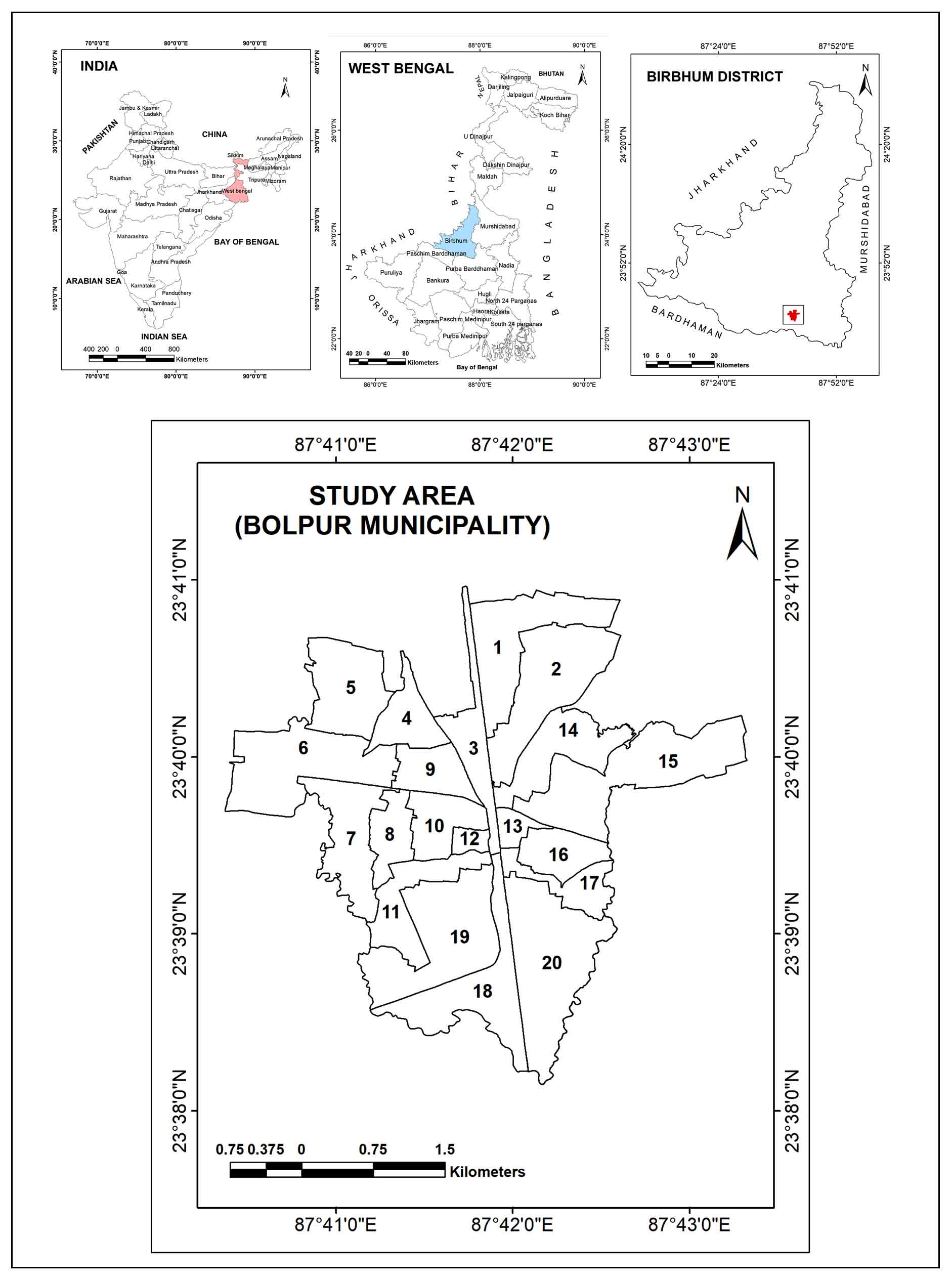
2 . STUDY AREA
Bolpur municipality (11.99km2) is located in the southern part of the Birbhum district, West Bengal, India and lies between 87°40'24.864"E to 87°43'23.129"E and 23°38'7.587"N to 23°40'58.094"N (Figure 1). This region is formed by hard-rock with more or less plain surface with lesser undulating topography. The northern region is occupied by some more undulating terrain having a slope of >20º. Some areas in the central part having steep slopes and southern parts have less undulating topography having slope about 10º-13º. The region is enclosed on the north by Nanoor, on the south by Ajoy River and on the west by Illambazar block. Average precipitation in the region is 143cm and temperature varies from 12.7ºC to 28.3ºC in winter and 25.5ºC to 41.5ºC in summer seasons.
Figure 1. Study area: Bolpu Municipality, West Bengal (India)
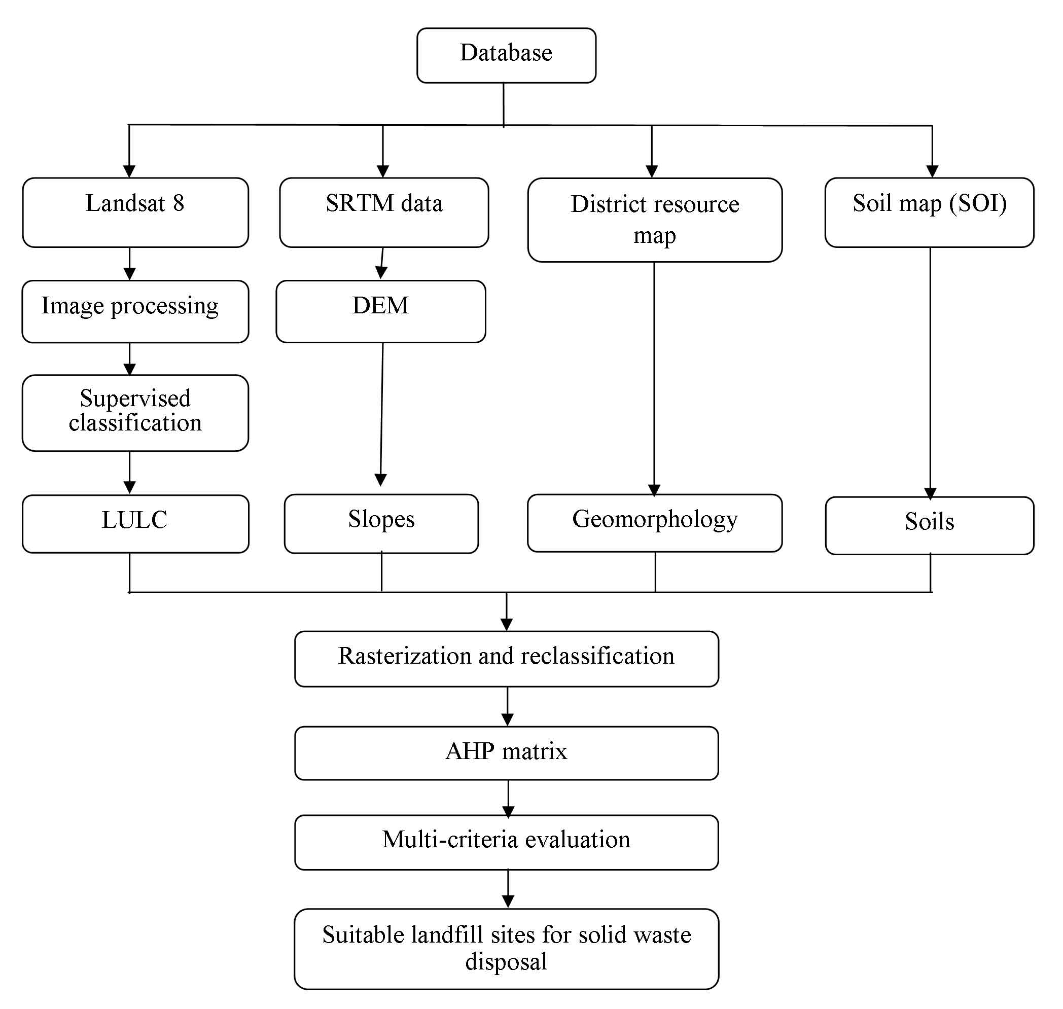
3 . DATA AND METHODOLOGY
Four steps (Figure 2) were used to analyse the site suitability for solid waste disposal in the Bolpur town: (i) preparation of different thematic layers, (ii) rasterization and reclassification, (iii) ranking and weighted analysis, and (iv) delineation of suitable sites for solid waste disposal.
Figure 2. Methodology
3.1 Preparation of Thematic Layers
Different thematic maps were prepared using RS images, topographic (SOI) and geological maps (GIS) in GIS environment. All thematic maps such as land use / land cover map (LU/LC), soil map, geological map, topographical map prepared in GIS environment. The LU/LC map is prepared by using Landsat-8 (OLI sensor) satellite dataset using supervised classification in ERDAS Imagine 2013 software (Kumar et al., 2014). The slope map was derived based on the SRTM digital elevation model (DEM). The soil map and geological map was prepared from SOI [Soil Survey of India] and GSI [Geological Survey of India] (Chowdhury et al., 2010; Ghayoumian et al., 2007).
3.2 Assignment of Weights
Analytical Hierarchical Process (AHP) was used as a decision support system for analyzing the spatial data for suitable site selection for solid waste disposal using GIS (Sehnaz et al., 2010). AHP is a pairwise weighted comparison matrix which is extracting weighted by eigenvalue and eigenvectors of principal component analysis (Theo, 2010; Sehnaz et al., 2010). The interrelationship between of four thematic layers has been developed and recognized using the AHP (Kadam et al., 2017) (Figure 2). All weights of input layers combined based on the information from different factor maps. The weight of all thematic maps were decided from the framework and independently incorporated with the advances of all those thematic classes using the AHP technique (Jhariya, 2016). In 9-point scale, ranging from 1 [minimum importance] to 9 [extremely importance] (Saaty, 1980) was used in the decision-making process for selection of waste disposal sites for Bolpur town.
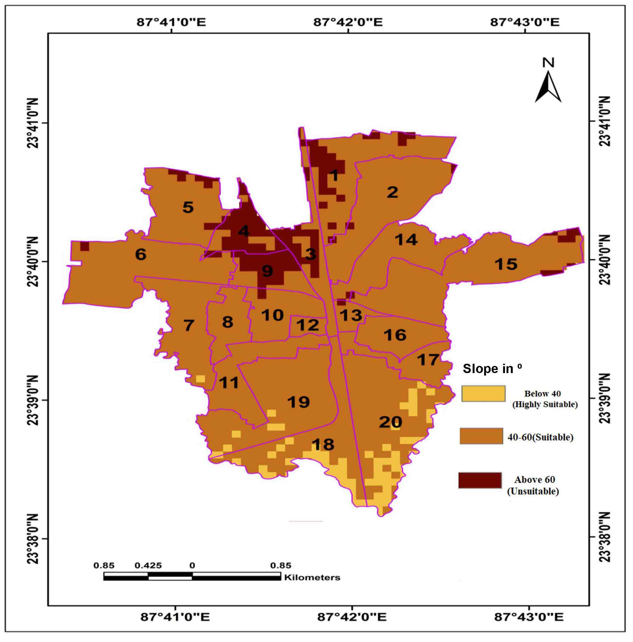
The slope can measure the changes in the terrain values at a distance and it can be expressed by the degree or percentage. Each raster grid cell represents a particular value and compared with conjoint to the reference point (Rajasekhar et al., 2018). Slope map of the region (Figure 3) is extracted from SRTM-DEM in GIS environment and classified into three categories: Below 40º, 40-60º, and above 60º (Table 2). The slope below 40º is highly suitable, while above 60º is unsuitable for site selection for waste disposal.
Figure 3. Slopes
Table 2. Slope classification
Levels (º)
Suitability levels
Below 40
Highly suitable
40-60
Suitable
Above 60
Unsuitable
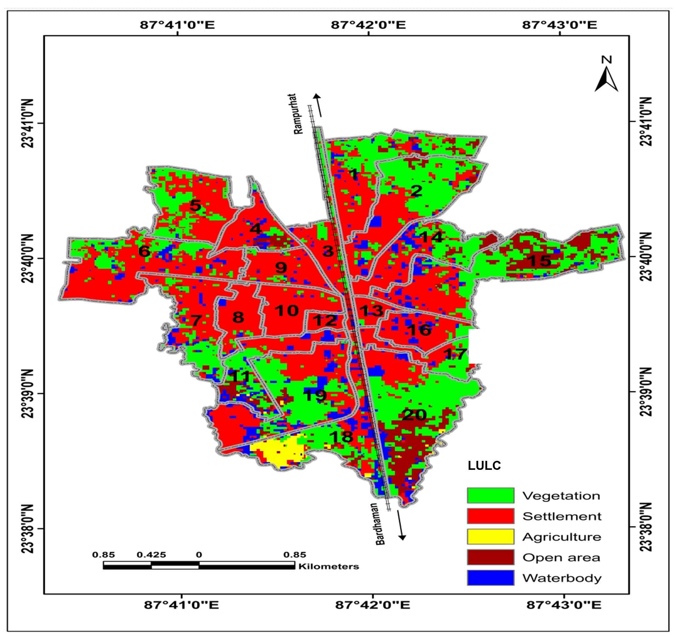
Land use/Land cover (LU/LC)
Land use / land cover map was produced using ERDAS Imagine 2013 software with supervised classification techniques, maximum likelihood algorithm based on the signature of the various features in the study area. Four LULC types have been identified (Figure 4) as namely vegetation, agricultural lands, open lands, built-up and water bodies. Vegetation and open area are most suitable for solid waste disposal and less suitable is agricultural lands, built-up lands and water (Table 3).
Figure 4. Land use land cover
Table 3. LULC classification
LULC
Suitability levels
Open area
Highly suitable
Vegetation
Suitable
Built up area
Less suitable
Agriculture
Very less suitable
Water bodies
Unsuitable
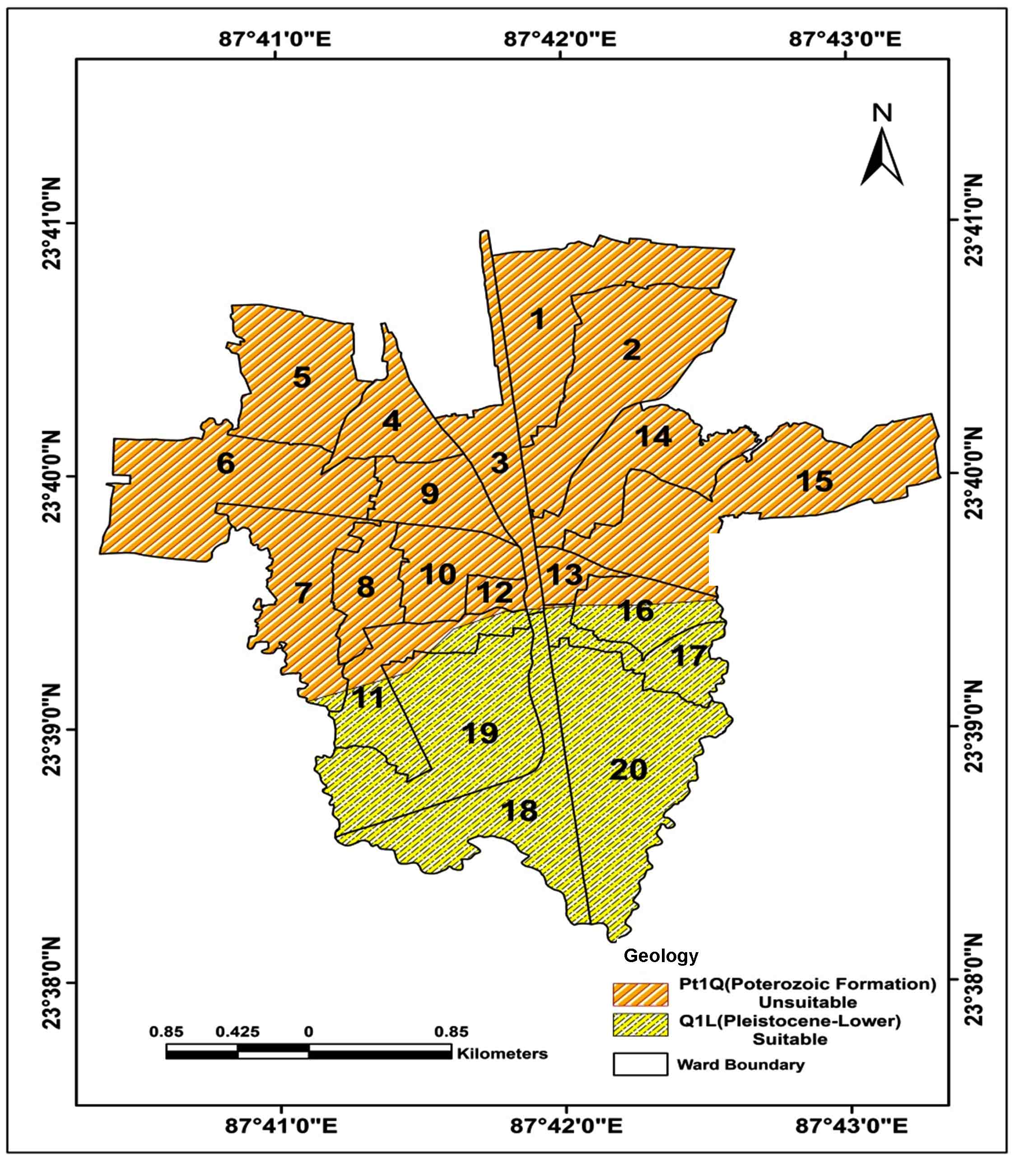
Geology
The geological formation of this region incorporates pleistocene-lower formation and poterozoic formation. On the contrary, the suitability increases from poterozoic formation to pleistocene-lower formation (Figure 5). The study area is composed by proterozoic formation in the Northern part, that is unsuitable for solid disposal and pleistocene-lower formation in Southern part of the region that is suitable (Table 4).
Figure 5. Geology
Table 4. Geology
Formations
Suitability levels
Pleistocene-lower formation
Highly suitable
Proterozoic formation
Unsuitable
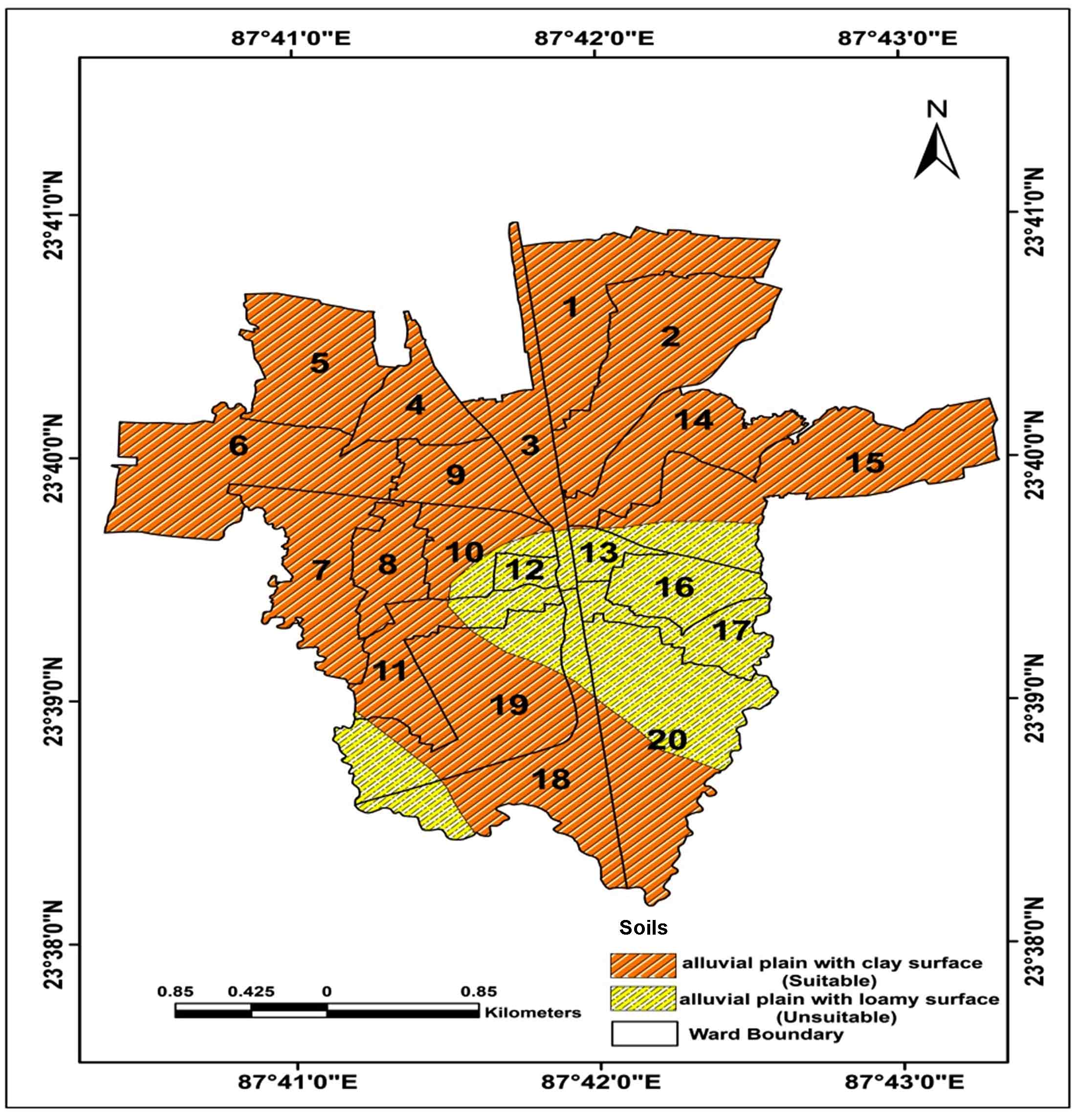
Soils
Soil map was prepared based on information generate from SOI (Soil Survey of India) (Figure 6). The soil in the region includes two principal classes: Alluvial plain with clay surface and alluvial plain with loamy surface. Alluvial plain with clay surface soil is suitable for disposal of solid waste and unsuitable soils are alluvial plain with loamy surface (Table 5).
Figure 6. Soils
Table 5. Soils
Types
Suitability levels
Alluvial plain with clay surface
Suitable
Alluvial plain with loamy surface
Unsuitable
3.4 Aggregation of Suitable Sites
WLC (Weighted Linear Combination) is a method with which is a multiplied all standardized, weighted factors map based on the given better weighted for better sites selection for solid waste disposal. WLC (equation (1)) are analyzed and developed the site suitability for waste disposal system.
(1)
where, is site suitability, is the weight of the factors map ( ), and is the criteria score of the factors based on the above equation. They were changed to bytes binary format and multiplied by the constant map to remove out the unsuitable area for solid waste disposal. Binary coded of an image was identified for the study area using a constant map, where suitable sites for solid waste disposal are not possible due to the environmental and economic factors as a zero value and remaining are shown as one. Therefore, equation (1) was modified as:
(2)
where, S is the site’s suitability, is the weight of the factors map of i, and is the criteria score of factors map i and is a constant map. This equation was used and identified the suitable sites for the potentiality of solid waste disposal.
4 . RESULTS AND DISCUSSIONS
4.1 Determinants of Suitable Sites for Waste Disposal
A detailed methodology for assessing suitable site selection for solid waste disposal in the region requires a thorough study of various parameters, such as slope, LULC, geology, soil, etc. Distinct thematic layers were prepared based on RS and conventional data in GIS software.
Slope
The topography in this region is dominantly controlling factor for solid waste management. Topography of the study area found high suitable in 67.48% (8.09 km2) and moderate suitable in 13% (1.59 km2) area and 19.22% (2.30 km2) is unsuitability area for waste disposal site (Table 6).
Table 6. Slopes and suitability
Suitability classes
Suitability weights
Area
km2
%
Highly Suitable
4
8.09
67.48
Moderately Suitable
3
1.59
13.29
Unsuitable
1
2.30
19.22
Total
11.98
100
Land use land cover
Land use land cover (LULC) map was prepared from Landsat-8 imagery and used supervised classification techniques that it validated based on field data with overall accuracy of 81.34% using ERDAS Imagine 2013. Large part in the study area is covered by built-up which are about 50.13% (61.16 km2) and open area, vegetation, agriculture and water body area are 7.86% (9.59km2), 32.08% (39.13km2), 1.33% (1.63km2) and 8.58 % (10.47km2), respectively (Table 7). From suitability point of view, open area (7.86%; 9.59km2) was found as highly suitable for solid waste disposal whereas vegetation is 32.08% (39.13km2), built-up area is 50.13% (61.16 km2), and agricultural land 1.33% (1.63km2) of the area were found suitable, moderately suitable and less suitable, respectively for waste disposal. The remaining 8.58% (10.47km2) area is under water bodies found unsuitable for solid waste disposal.
Table 7. LULC and suitability
LULC
Suitability classes
Suitability weights
Area
km2
%
Open area
Highly suitable
5
9.59
7.86
Vegetation
Suitable
4
39.13
32.08
Built up area
Less suitable
3
61.16
50.13
Agriculture
Very less suitable
2
1.63
1.33
Water bodies
Unsuitable
1
10.47
8.58
Total
121.99
100
Geology
For this study, the selection of the suitable rock type for site selection was based on amount of toughness and porosity. They are found in the south and northwestern and northeastern part of the study area and characterized by high porosity and western part is highly rough. Therefore, they are unsuitable for selection as landfill site. Most suitable geological classes in the study area is pleistocene-lower formation which covers 32.56% (3.90 km2) area and it found Northeastern part of the study area. The remaining 67.44% (8.08 km2) area of proterozoic formation is found in the Central and Central-Western parts of the study area (Table 8) is moderate suitability for solid waste disposal.
Table 8. Geology and suitability
Formation
Suitability
Suitability weights
Area
km2
%
Pleistocene-lower formation
Highly suitability
5
3.90
32.56
Proterozoic formation
Moderate suitability
3
8.08
67.44
Total
11.99
100
Soils
The soil map was prepared based on map from SOI with categories as: alluvial plain with clay surface soil is covered by 78.55% (9.42 km2) they are mainly found in the Northern, Central and Southern part of the study area which is suitable for solid waste disposal sites. The second type of soil is alluvial plain with loamy surface soil is covered 21.45% (2.57 km2) area that are found in the Eastern and some parts of the central region that area unsuitable (Table 9).
Table 9. Soils and suitability
Soils
Suitability
Suitability weights
Area
km2
%
Alluvial plain with clay surface
Suitable
5
9.42
78.55
Alluvial plain with loamy surface
Unsuitable
3
2.57
21.45
Total
11.99
100
4.2 Weightage Analysis
The weighted module developed the pairwise comparison techniques to derive the weights and its consistency ratio for selection of sites for solid waste disposal in the study area. According to the Lawel et al. (2011), the ratio of consistency is equal and less than to 0.1, so it represented acceptable reciprocal matrix.
The ratio of the consistency is accepted in the study is 0.03. The factor values and weights are summarized (Table 10) and showing pairwise distribution of weighted criteria as reciprocal matrix.
Consistency ratio = 0.03 < 0.1, acceptable.
Table 10. Weights
Criterions
LULC
GE
SO
SL
Weights
Weights (%)
LULC
1
0.50
50
SL
1/2
1
0.25
25
SO
1/3
1/2
1
0.16
15
GE
1/4
1/3
1/2
1
0.10
10
Total
1
100
4.3 Aggregation of Landfill Suitability
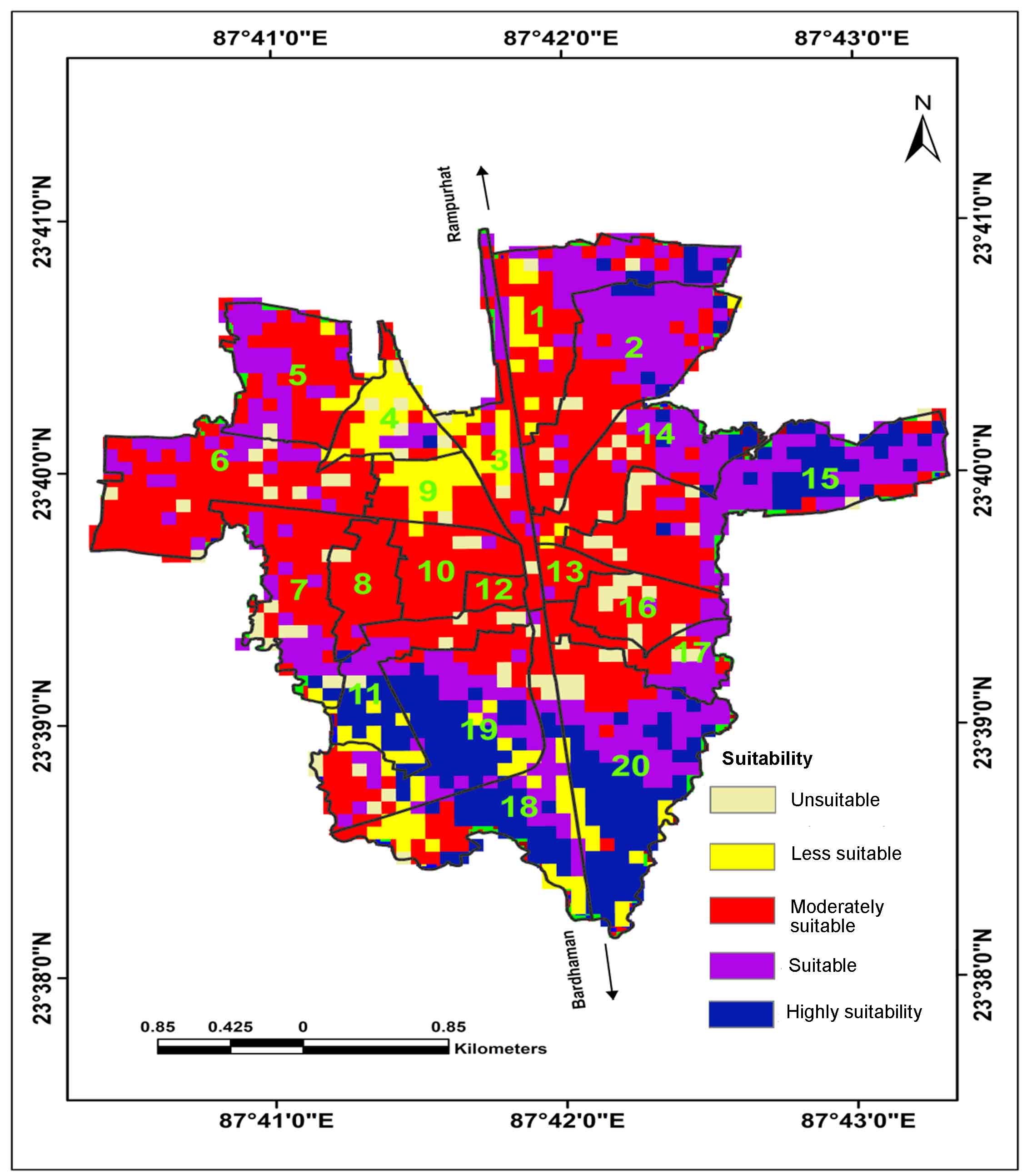
The study of landfill site suitability for solid waste disposal was based on the different components such as environmental condition, social and economic aspects. From the weight calculation, all parameters such as land use land cover (LULC), geology (GE), soil (SI), slope (SO) and these parameters are weighted assigned based on the surrounding environmental impact. The high weighted influence shows more importance for weighted criterion in all parameter. The series of pairwise comparison to provide weighted factors for suitable landfill and evaluated for all activity. The logical weights were produced and developed by Saaty (1980) to use the whole procedure under the Analytical Hierarchy Process (AHP) and put all weight rate based on the pairwise comparison in 9 points on continuous scale. The factor maps are highly important such as land use / land cover map, geological map, soil map, slope map to have overall landfill suitability for solid waste disposal. After all factors, maps, overlays and put weight through the linear combination methods to aggregation results showing five classes of suitability levels, such as; very high suitable, highly suitable, moderately suitable, less suitable and unsuitable area coverage (Table 11). Highly suitable landfill site 16.43% (1.97 km2) was found in the north-eastern part of the area. This region is satisfying the socially, economically and environmentally such as surface water, built-up land, slope, geology, land use/land cover area. The suitable area covers 28.55% (3.43 km2), the moderately suitable area covers 39.13% (4.70 km2), the less suitable area covers 9.49% (1.14 km2) and remaining 6.38% (0.77 km2) (Table 11) falls under the unsuitable for solid waste disposal sites (Figure 7). By using standard criteria for an established suitable landfill area for solid waste dumping where facilitate transportation and reduction transport cost. Landfill suitability for slope analysis that show less than 20 % where minimize environmental impacts and established site suitable area far away from the settlement, river, urban center. Highly suitable area of landfill sites is located in the northern part of the study area (Figure 7). Making an allowance for health, economy and other aspects on effects of solid waste and select most suitable perfect sites and accessed from the road.
Figure 7. Potential landfill suitability areas
Table 11. Landfill suitability
Suitability levels
Area
km2
%
Highly suitability
1.97
16.43
Suitable
3.42
28.55
Moderately suitable
4.69
39.13
Less suitable
1.14
09.49
Unsuitable
0.76
06.38
Total
11.98
100
5 . CONCLUSIONS
The suitable sites were identified from effective and efficient performance of the methodology, management and spatial data using GIS and AHP techniques. Therefore, very high suitability for landfill indicates for 16.43% (1.97km2) area and high suitability for 28% (3.42 km2) area for a solid waste disposal site. Suitable, moderately suitable and less suitable area were 39.13% (4.69km2), 9.49% (1.14km2) and 6.38% (0.77km2) in the total study area, respectively. The good suitability is considered by lower slope, vegetation and open lands in the study area. The less suitability for solid waste is found in Northern parts of the area that are mainly dissected plateau and highly fractured with agricultural lands. The integration of different multi-criteria analysis is a useful tool for problems solving of landfill suitable sites and precisely make for useful planers, researchers and policy makers who are involved in establishment and development of suitable sites for solid waste disposal and management in the Bolpur Town.
Tables
Figures
Conflict of Interest
The author declares no conflict of interest.
Acknowledgements
I am thanks to Earth System Science Department of Vidyasagar University, West Bengal, India for continuous support during the work. I also acknowledge the editor and reviewer for constructive comments and suggestions to improve the structure and presentation of the manuscript.
Abbreviations
AHP: Analytical Hierarchy Process; DEM: Digital Elevation Model; GE: Geology; GIS: Geographic Information System; GSI: Geological Survey of India; LULC: Land Use Land Cover; RS: Remote Sensing; SL: Slope; SO: Soil; SOI: Soil Survey of India; SOI: Survey of India; SWD: Solid Waste Disposal; SWM: Solid Waste Management; WLC: Weighted Linear Combination.
References
1.
Adeofun, O., Achic, A., Ufoegbune, C., Gbadebo, M. and Oyedepo, A., 2011. Application of Remote Sensing and Geographic information for selecting dumpsites and transport routes. Proceeding of Environmental Management Conference. Federal University of Agricultural in Abeokuta, Nigeria.
Iyappan, L. and J. Gopi Krishna, 2017. Suitable site selection for urban solid waste disposal using GIS in Vellore Taluk. International Journal of Applied Engineering Research, 9(22), 5708-5715.
Mondal, A., 2018. Municipal solid waste characterisation and quantification as a measure towards effective waste management in Bolpur Municipality, West Bengal. Online International Interdisciplinary Research Journal, 08(01).


 (1)
(1) is site suitability,
  is the weight of the factors map (
  ), and
  is the criteria score of the factors based on the above equation. They were changed to bytes binary format and multiplied by the constant map to remove out the unsuitable area for solid waste disposal. Binary coded of an image was identified for the study area using a constant map, where suitable sites for solid waste disposal are not possible due to the environmental and economic factors as a zero value and remaining are shown as one. Therefore, equation (1) was modified as:
 (2)
(2) is the weight of the factors map of i, and
  is the criteria score of factors map i and
  is a constant map. This equation was used and identified the suitable sites for the potentiality of solid waste disposal.