Article Title :
GIS-based MCDA for Gully Vulnerability Mapping Using AHP Techniques 
BASHIR ISHAKU YAKUBU
 ,
Sallau Rachel Osesienemo
,
Sheikh Abubakar Danjuma
,
Aminu Zunni
,
Hassan Shu’aib Musa
,
Sallau Rachel Osesienemo
,
Sheikh Abubakar Danjuma
,
Aminu Zunni
,
Hassan Shu’aib Musa
4 (2020)
45-63
MCDA , Multilayer , Gully Vulnerability Mapping , GIS , Basin characteristics , AHP


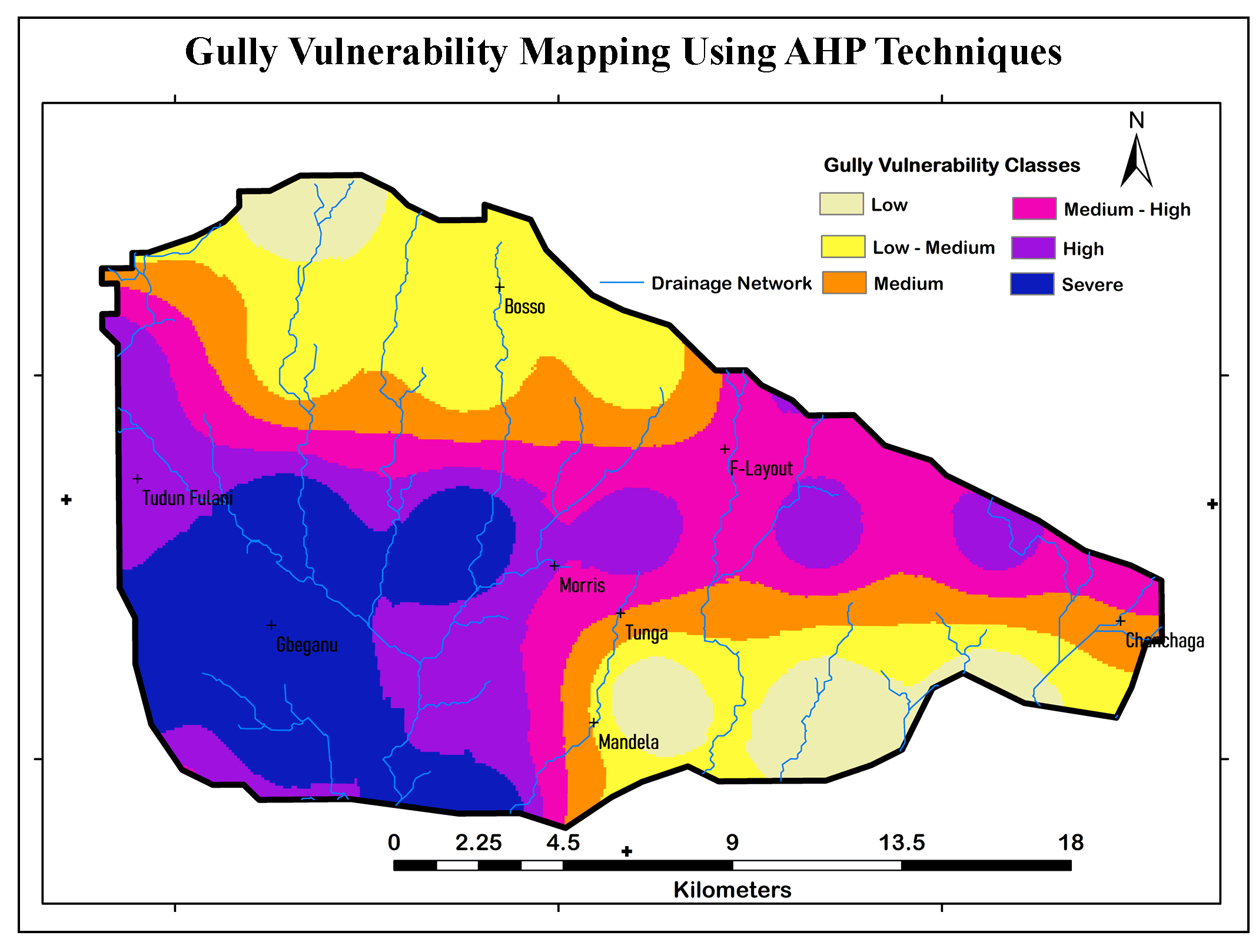
This paper explores the potentiality of GIS-based Multi-Criteria Decision Analysis (MCDA) and Analytical Hierarchy Process (AHP) for gully vulnerability mapping. Multilayer information of basin characteristics, such as drainage density, Topographic Wetness Index (TWI), Stream Power Index (SPI), slope aspect and land use land cover (LULC), were used in this study to develop a Gully Vulnerability Index (GVI). A weighted approach was implemented on each criterion relative to their inferred influence on gully vulnerability and validated by determining the Consistency Ratio (CR). Findings show a varying magnitude of gully vulnerability across the study area. The low to medium gully vulnerability class was dominant covering a land area of 6557ha (21.25%), and mostly confined to developed areas. Still, it is noteworthy to observe that the severe gully vulnerability class covers a substantial land area of 5825ha (18.88%), which presents a great risk to infrastructural development and human settlements in the study area. The study has a model predictive capability with accuracy rate of 84.62%. The integration of the MCDA and AHP into GIS workflow is an effective approach critical to minimize the limitations associated with gully occurrence analysis, using a singular basin characteristic. The results obtained in the study will equally be important in determining gully risk zones, circumspect urban development, tracking and proper infrastructure construction plans for long-term gully disaster mitigation.
The integration of MCDA and AHP techniques was used for mapping of gully vulnerability.
Drainage density, Topographic Wetness Index (TWI), Stream Power Index (SPI), Slope aspect, LULC, etc. were used estimation of Gully Vulnerability Index (GVI).
Findings show a varying magnitude of gully vulnerability across the study area.
The model shows good predictive capability with accuracy of 84.62%.
Abdulazeez, A., Sani, F. K., and Labaran, H. B., 2018. A spatial assessment for the extent and severity of gully erosion in Dawakin-Tofa LGA, Kano State. International Journal of Geography and Environ. Management, 4(2), 25-38.
Ajaero, C. K., and Mozie, A. T., 2010. The Agulu-Nanka Gully Erosion Menace In Nigeria: What Does the Future Hold for the Population at Risk? Climate Change and Migr: Rethinking Policies for Adapt. and Disaster Risk Red., 74-81.
Ambalam, K., 2014. Challenges of compliance with multilateral environmental agreements: The case of the United Nations Convention to Combat Desertification in Africa. J. of Sustainable Devt. Studies, 5(2), 145-168.
Aminu, Z., and Jaiyeoba, I. A., 2016. An assessment of soil degradation in Zaria Area, Kaduna State, Nigeria. IFE Research Publications in Geography, 13(1), 27-37.
Arabameri, A., Pradhan, B., Rezaei, K., Yamani, M., Pourghasemi, H. R., and Lombardo, L., 2018. Spatial modelling of gully erosion using evidential belief function, logistic regression, and a new ensemble of evidential belief function–logistic regression algorithm. Land degradation and devt., 29(11), 4035-4049.
Araki, S., 2012. Morphology and Formation of Gully Features on Mars Using Mars Reconnaissance Orbiter Context Images. (Master of Scienc), University of Illinois at Chicago, Chicago, Illinois.
Ayele, G. K., Gessess, A. A., Addisie, M. B., Tilahun, S. A., Tenessa, D. B. L., Eddy J., Steenhuis, T. S., and Nicholson, C. F., 2015. The economic cost of upland and gully erosion on subsistence agriculture for a watershed in the Ethiopian highlands. African J. of Agricultural and Res. Economics, 10(2), 265-278.
Dashti, S., Monavari, S. M., Hosseini, S. M., Riazi, B., and Momeni, M., 2013. Application of GIS, AHP, Fuzzy and WLC in island ecotourism development (Case study of Qeshm Island, Iran). Life Science Journal, 10(1), 1274-1282.
Goudie, A. S., 2018. Human impact on the natural environment: John Wiley and Sons.
Gudino‐Elizondo, N., Biggs, T. W., Castillo, C., Bingner, R. L., Langendoen, E. J, Taniguchi, K. T., Kretzschmar, T., Yuan, Y., and Liden, D., 2018. Measuring ephemeral gully erosion rates and topographical thresholds in an urban watershed using unmanned aerial systems and structure from motion photogrammetric techniques. Land degradation and development, 29(6), 1896-1905.
Handl, G., 2012. Declaration of the United Nations conference on the human environment (Stockholm Declaration), 1972 and the Rio Declaration on Environment and Development, 1992. United Nations Audiovisual Library of International Law, 11.
Huang, Y. L., Chen, L. D., Fu, B. J., and Wang, Y. L., 2005. Spatial pattern of soil water and its influencing factors in a gully catchment of the Loess Plateau. Journal of Natural Resources, 20(4), 483-492.
Jetten, V., Poesen, J., Nachtergaele, J., and Van de Vlag, D., 2006. Spatial Modelling of Ephemeral Gully Incision: Physical Approach. Soil erosion and sediment redistribution in river catchments: Measurement, modelling and management, 195.
Lal, R., 2017. Soil erosion by wind and water: problems and prospects. In Soil erosion research methods, 1-10. Routledge.
Mahmud, H. L., and Umaru, E. T., 2018. Impact of gully erosion on landuse/land cover in Bida Town Niger State, Nigeria. Intl. J. of Geography and Environmental Management, 4(2), 7-15.
Matlab, V., 2010. The MathWorks Inc., Natick, Massachusetts.
Patil, R. J., 2018. Spatial Techniques for Soil Erosion Estimation: Remote Sensing and GIS Approach. Springer.
Pokhara, S., 2008. Conservation of Phewa Lake of Pokhara, Nepal. NLCDC, Ministry of Culture, Tourism and Civil Aviation.
Saaty, T. L., 1980. The analytic hierarchy process: planning, priority setting, resources allocation. M cGraw-Hill.
Sajedi‐H., Farzaneh, C., Bahram, S., Karim, Cerdà, A., and Kavian, A., 2018. Spatial prediction of soil erosion susceptibility using a fuzzy analytical network process: Application of the fuzzy decision-making trial and evaluation laboratory approach. Land degradation and development, 29(9), 3092-3103.
UNCCD [United Nations Convention to Combat Desertification], 1994. Paper presented at the United Nations Environmental Programme, Geneva.
Valjarević, A., Srećković-Batoćanin, D., Živković, D., and Perić, M., 2015. GIS analysis of dissipation time of landscape in the Devil's city (Serbia). Acta Montanistica Slovaca, 20(2).
Wischmeier, W. H., and Smith, D. D., 1978. Predicting rainfall erosion losses-a guide to conservation planning. Predicting rainfall erosion losses-a guide to conservation planning.
Yusoff, I. M., Rahman, A. A., and Katimon, A., 2007. GIS based hydrologic modelling for infiltration excess overland flow. Paper presented at the proceedings of joint international symposium & exhibition on geoinformation 2007 & international symposium on GPS/GNSS (ISG-GNSS2007), Persada Johor International Convention Centre, Johor Bharu Malaysia.
Zabihi, M., Pourghasemi, H. R., Motevalli, A., and Zakeri, M. A., 2019. Gully erosion modeling using GIS-based data mining techniques in northern Iran: A comparison between boosted regression tree and multivariate adaptive regression spline. In Natural Hazards GIS-Based Spatial Modeling Using Data Mining Techniques, 1-26. Springer.