

Article Title :
Coastal Stability using Remote Sensing and Radioactive Materials in the Northwest Nile Delta Coast, Egypt 
5 (2021)
14-26
Radioactive Material , Remote Sensing , Nile Delta , Coastal Stability


This paper points to changes of the coastline using two ways, calculating the annual rate of erosion using 1) radioactive materials and 2) GIS and DSAS extension. Finally, both results were verified. Radioactivity results indicate both erosion and accretion zones, the annual scavenging rate in Promontory area shows that it is presented main accretion area, unlike the results of the DSAS extension, which showed that the Promontory is erosion area. The Burullus area annual scavenging rate results showing erosion, despite results of DSAS, it shows that it is an accretion area, but this was clarified by calculating the average distance between the shoreline of 2017 and 2018, and the 2018 shoreline retreat with an average distance 41.4 cm, which makes the Burullus region suffer from erosion. Two methods showed similarity in results in the Edco area, which shows that the Edco area suffers from erosion.
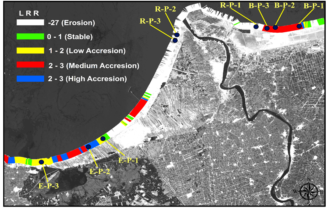
Promontory is presented main accretion area, unlike the results of the DSAS extension.
It is erosion area, but according to nourishment process it makes it appear like accretion area.
The Burullus area is indicating erosion after calculating the annual scavenging rate between the shoreline of 2017 and 2018.
The two methods showed similarity in results in the Edco area, which shows that the Edco area suffers from erosion.
El-Hattab, M. M., 2015b. Improving coastal vulnerability index of the Nile Delta coastal zone, Egypt. Journal of Earth Science & Climatic Change, 6(8), 293.
Himmelstoss, E., 2009. DSAS 4.0 Installation Instructions and User Guide. Thieler, E. R., Himmelstoss, E. A., Zichichi, J. L., and Ergul, A., 2008-1278.
Leatherman, S. P., Kearney, M. S. and Clow, B., 1983. Assessment of Coastal Responses to Projected Sea Level Rise: Galveston Island and Bay, Texas. URF report TR-8301, ICF, EPA, College Park, Maryland, 193.
Niya, A. K., Alesheikh, A. A., Soltanpor, M. and Kheirkhahzarkesh, M. M., 2013. Shoreline change mapping using remote sensing and GIS. International Journal of Remote Sensing Applications, 3(3), 102-107.
Thieler, E. R., Himmelstoss, E., Miller, T. and Zichichi, J., 2005. User Guide and Tutorial for the Digital Shoreline Analysis System (DSAS) version 3.2. Extension for ArcGIS v. 9.0. USGS Open-File Report, 1304.
