
Journal Open access Double-blind peer review
Remote Sensing of Land
'Remote Sensing of Land' (RSL) publishes double-blind peer-reviewed articles within all fields of remote sensing of the land.
Editor-in-Chief Dr. Suresh Kumar (Agriculture, Forestry & Ecology Group, Indian Institute of Remote Sensing, Dehra Dun -248001, Uttarakhand, India.)
Managing Editor Dr. Kalpana Bhagat  (Gatha Cognition.)
- Articles published
- 38
- Crossref citations
- 292
- Citation ratio · Crossref
- 7.68
- Citation ratio · OpenAlex
- 9.55
Citation ratio = citations ÷ all articles published since the first issue.
Issue
Volume 5 (2021) · Issue 1-2
Original Research Paper
-
pp. 1-13 Open access
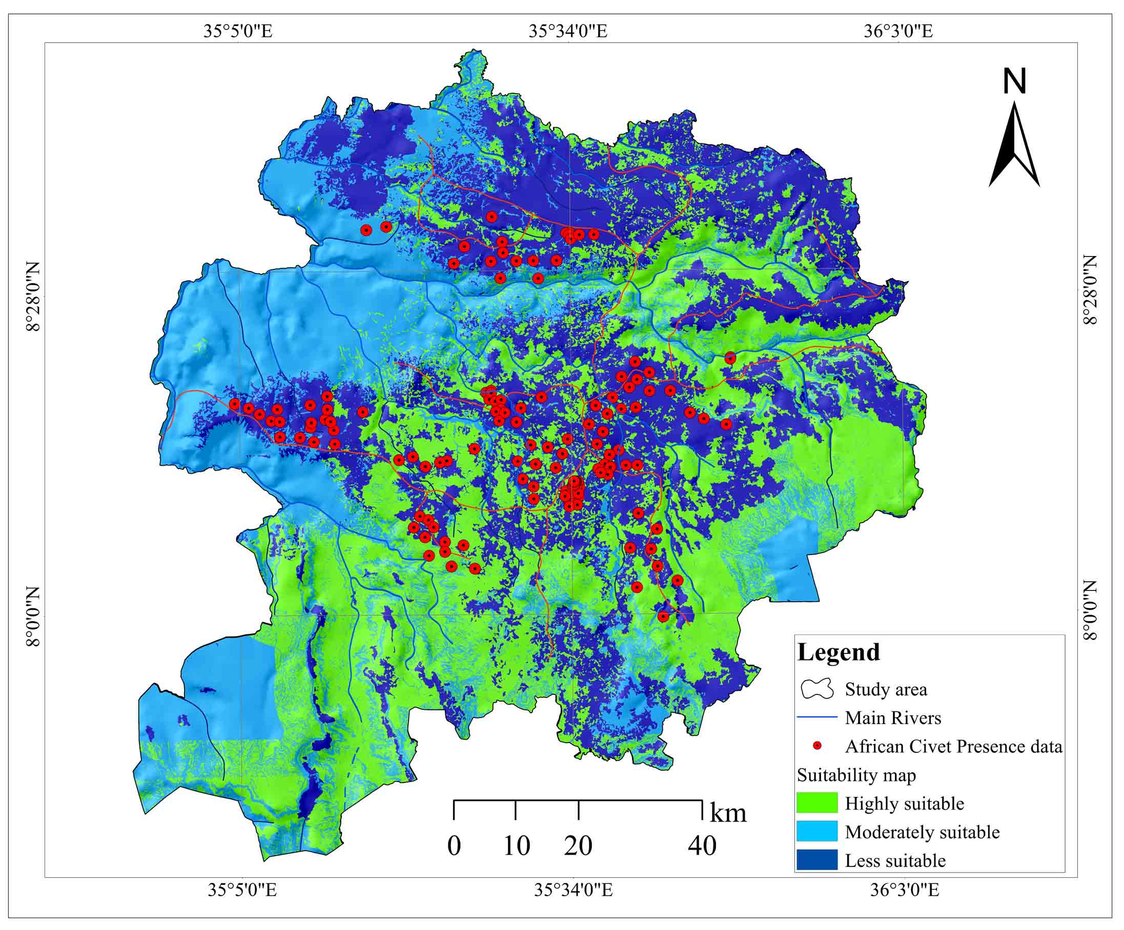
African Civet Habitat Mapping in Illu-Abbabora Zone, Southwest Ethiopia: Geospatial Approach
K. V. Suryabhagavan, Mintesnot Berhanu, Bezawork Afework, Afework Bekele, M. Balakrishnan
The African Civet (Civettictis Civetta Shreber, 1778) is one of the important natural animal resources of Ethiopia. Ethiopia is the major producer of the Civet perineal gland secretion (known as “civet”) used extensively as a base in perfume industry. However, there is no improvement in civet farming processes in rural Ethiopia, and the farmers still live in a poor state. Majority of rural population in Ethiopia is d…
10.21523/gcj1.2021050101 2,182 views 9 Nov 2020
-
pp. 14-26 Open access
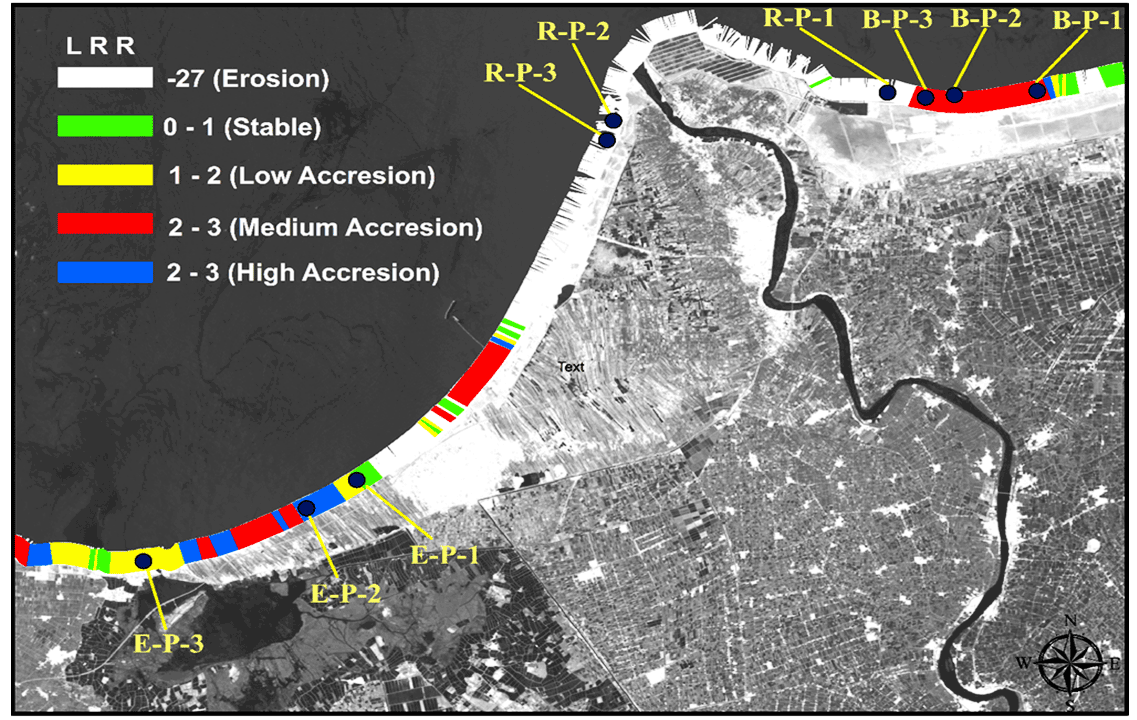
Coastal Stability using Remote Sensing and Radioactive Materials in the Northwest Nile Delta Coast, Egypt
Mamdouh El-Hattab, Ibrahim Saleh, Ayat Mohamed
This paper points to changes of the coastline using two ways, calculating the annual rate of erosion using 1) radioactive materials and 2) GIS and DSAS extension. Finally, both results were verified. Radioactivity results indicate both erosion and accretion zones, the annual scavenging rate in Promontory area shows that it is presented main accretion area, unlike the results of the DSAS extension, which showed that t…
10.21523/gcj1.2021050102 956 views 31 Jan 2021
-
pp. 27-40 Open access
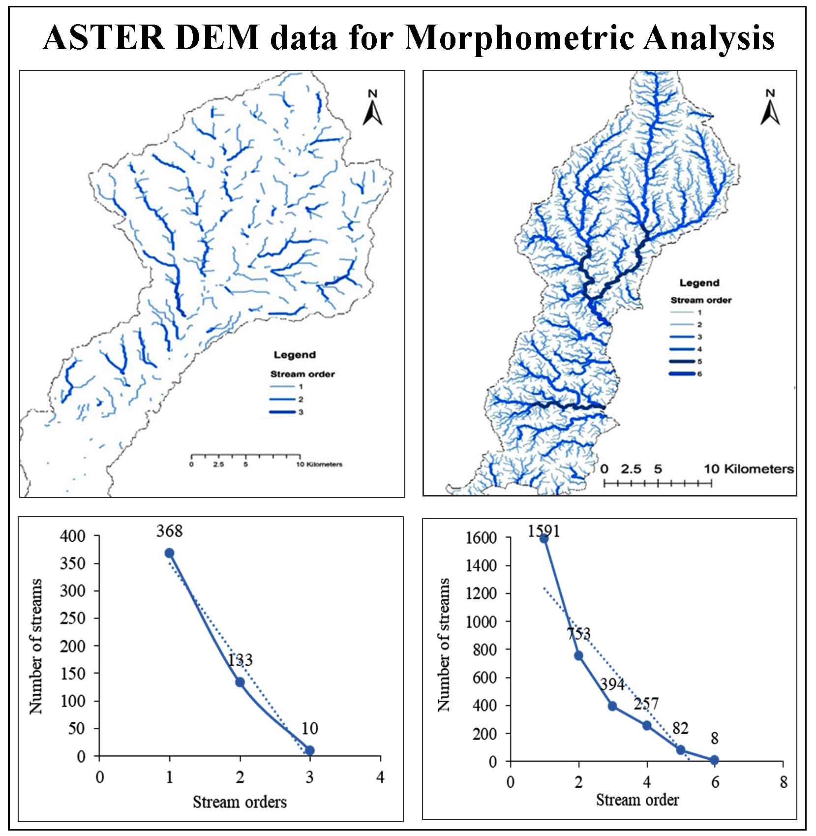
Use of ASTER DEM data for Morphometric Analysis of Megech-Dirma Watersheds, Blue Nile Basin, Ethiopia: Implications for Soil and Water Conservation
Quantitative morphometric analysis was carried out for Megech-Dirma, sub-basin of the Blue Nile, by estimating (1) linear, (2) aerial, and (3) relief aspects. An endeavor has been made to measure the Megech-Dirma watershed’s morphometric characteristics to implement conservation methods for soil and water properly. ASTER DEM has been used as input data for extracting morphometric parameters. Strahler’s classification…
10.21523/gcj1.2021050103 3,106 views 1 citation 10 Apr 2021
-
pp. 41-58 Open access
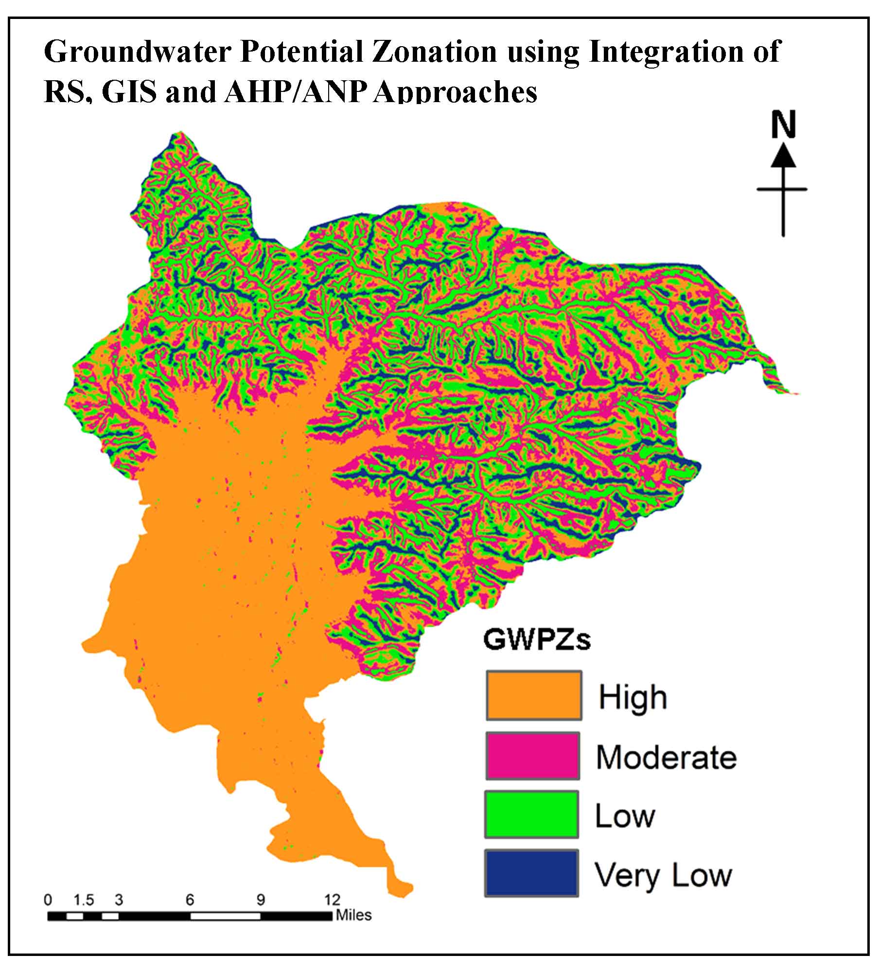
Groundwater Potential Zonation using Integration of Remote Sensing and AHP/ANP Approach in North Kashmir, Western Himalaya, India
Sajad Mir, M Sultan Bhat, G.M Rather, Durdanah Mattoo
The demand for groundwater resource estimation has increased radically attributed to the growing population and rapid urbanization. To analyze the groundwater scenario the present study aims to delineate the groundwater potential zones (GWPZ’s) using the integrated remote sensing (RS) and Geographic Information System (GIS) based approach and AHP/ANP model in Western Himalaya. For the groundwater potentiality analysi…
10.21523/gcj1.2021050104 1,522 views 21 citations 6 May 2021
-
pp. 59-72 Open access
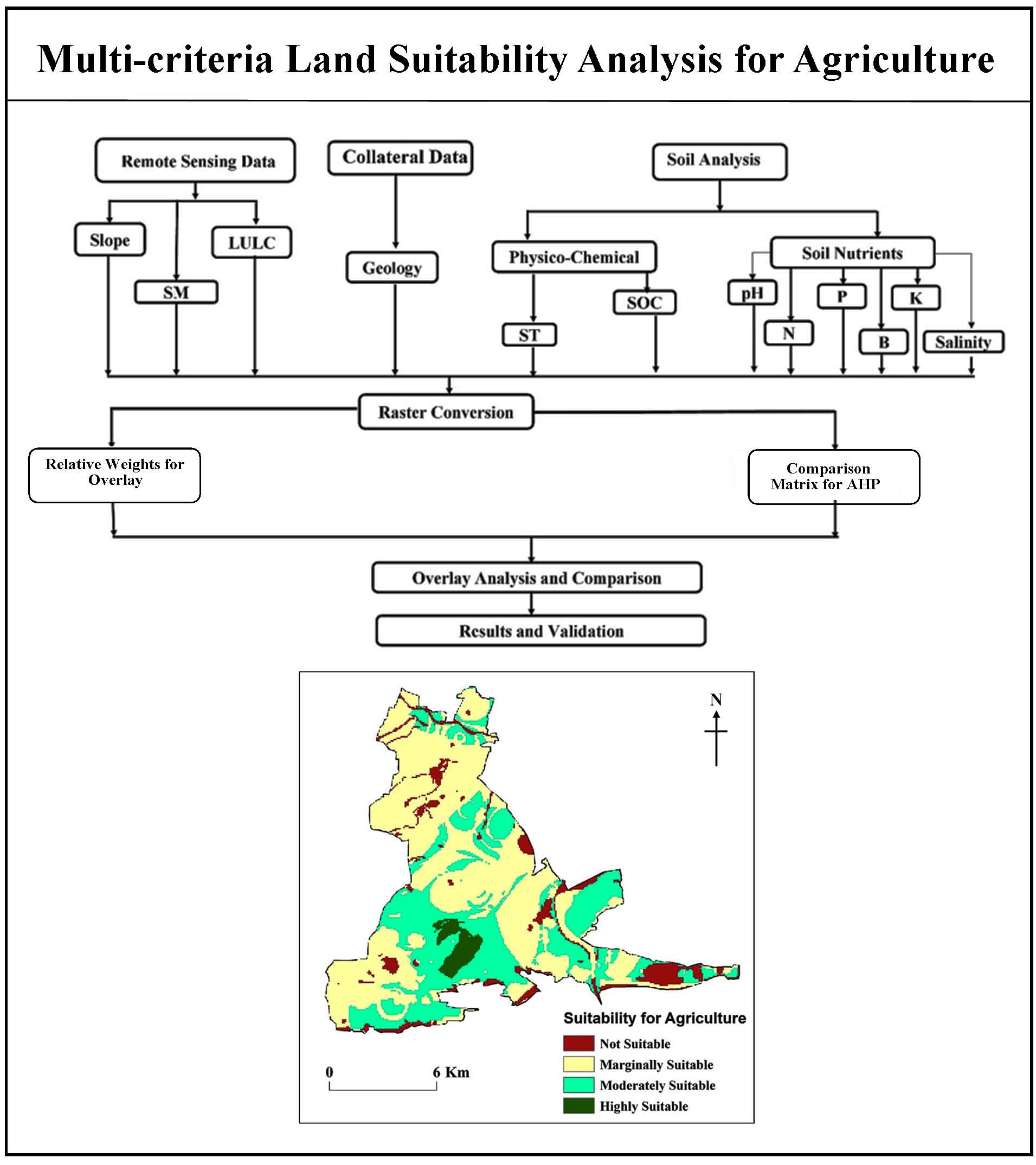
Multi-criteria Land Suitability Analysis for Agriculture in Semi-Arid Region of Kadapa District, Southern India: Geospatial Approaches
Rajasekhar M, Sudarsana Raju G, Nanabhau Kudnar, Ramachandra M, Pradeep Kumar Badapalli
This research proposes an integrated methodology for incorporating RS, GIS and AHP techniques for the assessment of agricultural land suitability. In Kadapa district, Andhra Pradesh, India, study is being done on how to best promote agriculture as a source of income to boost the economy of the region. A combined RS, GIS and AHP techniques has been utilized that incorporates organizing AHP hierarchy, criteria specific…
10.21523/gcj1.2021050201 2,106 views 27 citations 24 Jun 2021
Credits to reviewers (32)
- Dr. Vijay Bhagat, Post-graduate Research Centre in Geography, Agasti Arts, Commerce and Dadasaheb Rupwate Science College, Akole-422601, Ahmednagar, Maharashtra (India).
- Dr. Lachezar Filchev, Department of Remote Sensing and GIS, Space Research and Technology Institute at the Bulgarian Academy of Sciences (SRTI-BAS).
- Dr. Tarik Mitran, National Remote Sensing Centre, ISRO,Hyderabad – 500037 (India)
- Dr. Vanya Stamenova, Space Research and Technology Insitute - Bulgarian Academy of Sciences
- Dr. Chaitanya Pande, All India coordinate research project for dry land agriculture, Dr. Panjabrao Deshmukh Krishi Vidyapeeth, Akola
- Dr. Kishor R. Sonawane, Post-graduate Research Centre in Geography, Agasti Arts, Commerce and Dadasaheb Rupwate Science College, Akole-422601, Ahmednagar, Maharashtra (India).
- Professor. Ayad Al-Quraishi, Environmental Engineering Dept., College of Engineering, Knowledge University, Erbil 44001
- Dr. Sainath Aher, Post Graduate Department of Geography, S. N. Arts, D. J. Malpani Commerceand B.N. Sarda Science College, Sangamner 422 605, India
- Mr. Milad Janalipour, Department of Photogrammtery & Remote SensingFaculty of Geodesy and Geomatics EngineeringK. N. Toosi University of Technology
- Professor. Ali Mohammadzadeh, Remote Sensing Dept., Faculty of Geomatics Engineering, K.N.Toosi University of Technology, Tehrān, Iran.
- Dr. S. Sarvade, Assistant Professor, Department of Forestry, JNKVV Jabalpur
- Dr. SN Patil, Department of Geology, School of Environmental and Earth Sciences, North Maharashtra University, Jalgaon-425001, Maharashtra (India)
- Dr. Shridhar Jawak, University Centre in Svalbard (UNIS), SIOS - Svalbard Integrated Arctic Earth Observing System, SIOS Knowledge Centre, P.O. Box 156, N-9171 Longyearbyen, Norway.
- Dr. Ajaykumar Kadam, Department of Geology, Savitribai Phule Pune University, Pune
- Mr. Kajal Kumar Mandal, Department of Disaster Management, Pondicherry University, Port Blair Campus, Andaman, India.
- Dr. Rajasekhar M, Department of Geology, Yogi Vemana University, Kadapa-516003, Andhra Pradesh (India).
- Dr. Hamdi Zurqani, University of Tripoli, Department Soil and Water Sciences
- Dr. K. V. Suryabhagavan, School of Earth Sciences, Addis Ababa University, P.O. Box 1176, Addis Ababa, Ethiopia.
- Dr. S.P Rao, University of Dodoma
- Mr. Abhishek Danodia, Indian Institute of Remote Sensing
- Mrs. Minakshi Kumar, Indian Institute of Remote Sensing
- Dr. Satyajit Gaikwad, Department of Geology, Savitribai Phule Pune University, Pune
- Dr. SHANKAR KARUPPANNAN, Department of Aplied Geology,School of Applied Natural Sciences (SoANS), Adama Science & Technology University, Adama, Ethiopia.
- Mr. Justin George K, Indian Institute of Remote Sensing
- Dr. Muhammad Sohail Memon, Department of Farm Power and Machinery, Faculty of Agricultural Engineering, Sindh Agriculture University, Tandojam, Pakistan
- Dr. Murugesan Bagyaraj, Department of Geology, College of Natural and Computational Sciences, Debre Berhan University, Debre Berhan, Ethiopia.
- Dr. Shrinwantu Raha, Bhairab Ganguly College, Belgharia-7,000,56, West Bengal, India.
- Dr. M. V Rao, Andhra University
- Dr. Pankaj Panwar, CSWCRTI, Chandigarh
- Dr. Sanjay Navale, Department of Geography, S. N. Arts, D.J.M. Commerce and B.N.S. Science College, Sangamner, Dist.Ahmednagar, Maharashtra (India), 422605.
- Mr. Justin George Kalambukattu, Agriculture and Soils Department,Indian Institute of Remote Sensing, ISRO, Dehradun 248001, Uttarakhand, India
- Professor. Rajendra Zolekar, Department of Geography, K.V. N.Naik College Nashik