

Article Title :
Use of ASTER DEM data for Morphometric Analysis of Megech-Dirma Watersheds, Blue Nile Basin, Ethiopia: Implications for Soil and Water Conservation 

5 (2021)
27-40
Geospatial technology , Megech-Dirma Watershed , Morphometric analysis , Soil Conservation , Water Conservation


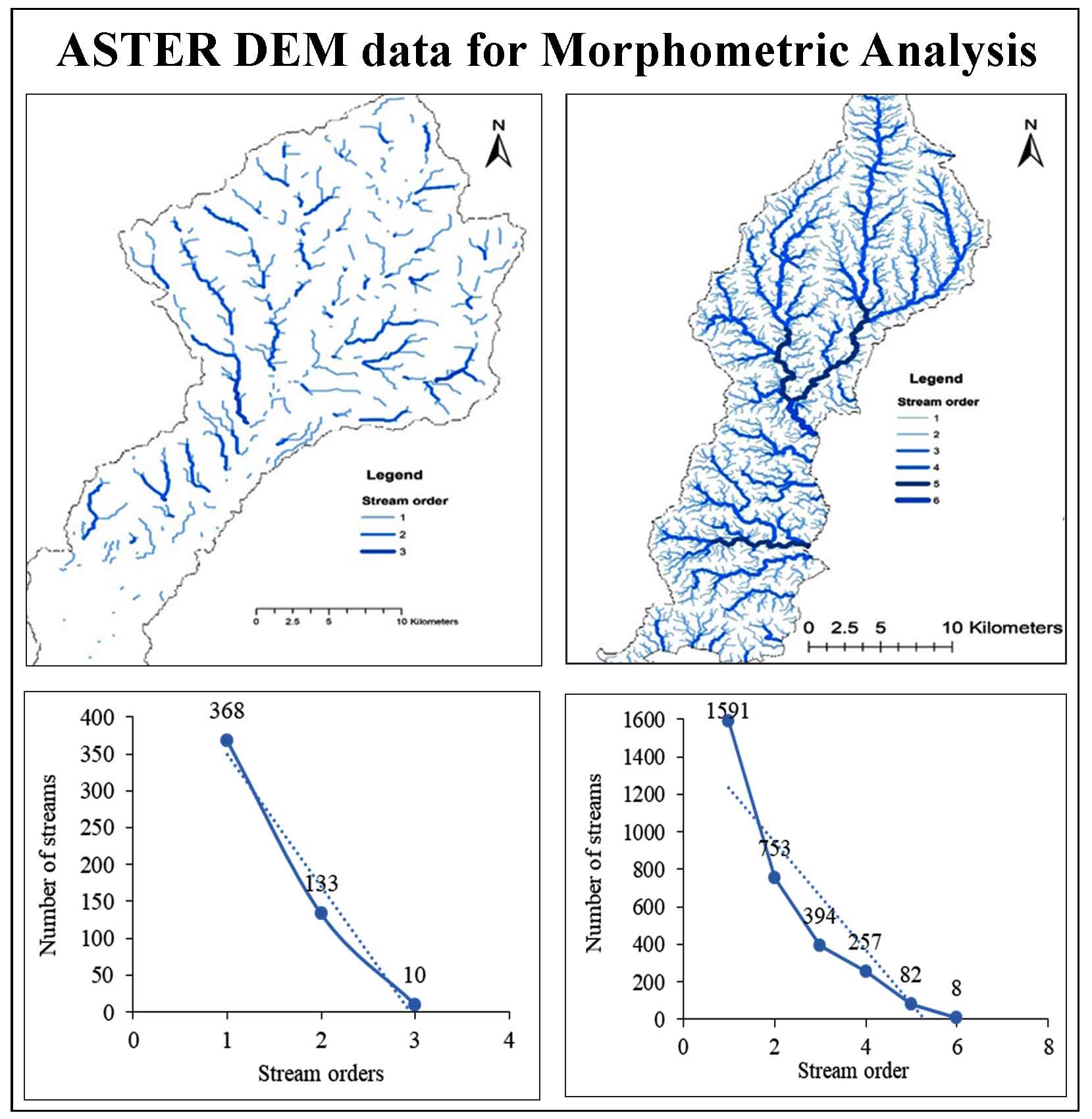
Quantitative morphometric analysis was carried out for Megech-Dirma, sub-basin of the Blue Nile, by estimating (1) linear, (2) aerial, and (3) relief aspects. An endeavor has been made to measure the Megech-Dirma watershed’s morphometric characteristics to implement conservation methods for soil and water properly. ASTER DEM has been used as input data for extracting morphometric parameters. Strahler’s classification scheme was used to classify the extracted drainage network in ArcGIS extension ArcMap 10.4. The watershed covers a total surface area of 1309.56 km2. The shape of the watersheds as calculated from elongation, circularity, and form factors reveals the elongated shape and the watersheds parade dendritic pattern. The sub-watersheds include third-order for Megech and sixth-order streams. Lower stream orders, in particular first-order streams, dominate the sub-watersheds. The length of overland flow has a higher value (1.06) for Megech indicates low relief, whereas the values of length of overland flow, which are relatively low (0.20) for Dirma, indicate high relief. The drainage density of the study watershed was morphometrically analyzed and obtained 0.47 km/km2 for the Megech sub-basin, which indicates the basin is highly permeable and result in better underground water storage capacity and 2.46 for the Dirma sub-basin indicating very coarse and coarse channel, respectively. The ruggedness number for Megech and Dirma sub-basins was 0.56 and 0.07, respectively, indicating moderate and long, rugged topography, which could be susceptible to flash flood and soil erosion. The dissection index values for Megech 0.40 and 0.36 for Dirma show river sub-basins are moderately dissected. The ruggedness number is 0.56 for Megech implies moderate soil erosion probability, whereas the high infiltration number (14.29) for Dirma river shows the high runoff potential in the sub-basin. The findings of this study include drainage morphometry data that can be used to better understand watershed characteristics and serve as a framework for better planning, management, and decision-making to ensure the long-term use of watershed resources of water and soil.
We have calculated morphometry of the Megech-Dirma watersheds•
The watershed is susceptible to soil erosion and flash floods due to moderate and long rugged topography.
High drainage density implies impermeable sub-soil and sparse vegetation cover exposing the soil for further.
The morphometric analysis show better groundwater storage potentials in these watersheds.
Abdi, N. K., Sahilu, I. G. and Ababa, A., 2016. Megech dam reservoir sediment estimation using swat model. 122.
Chavare, S. and Shinde, S. D., 2013. Morphometric analysis of Urmodi basin, Maharashtra using geospatial techniques. 4(1), 224-231.
Chitra, C., Alaguraja, P., Ganeshkumari, K., Yuvaraj, D. and Manivel, M., 2011. Watershed characteristics of Kundah subbasin using remote sensing and GIS techniques. Int J Geomatics Geosci, 2(1), 311-335.
Everest, T. and Özcan, H., 2018. Possibility of determining groundwater storage potential with cartographic materials, morphometric analysis and GIS. Uluslararası Su ve Çevre Kongresi SUÇEV, March 2018.
Faniran, A., 1968. The index of drainage intensity- A provisional new drainage factor. Australian Journal of Science, 31, 328-330.
FAO [Food and Agriculture Organization], 2002. Major Soils of the World, Land and Water Digital Media Series Food And Agricultural Organization of +e United Nations, Rome, Italy.
Gabale, S. M., and Pawar, N. R., 2015. Quantitative morphometric analysis of Ambil Odha (Rivulet) in Pune, Maharashtra, India. Journal of Environmental Science, Toxicology and Food Technology, 9(7), 1-9.
Goyal, R. and Munoth, P., 2019. Identification of relationships among morphometric parameters and QSWAT model output. International Conference on SWAT, University of Natural Resources and Life Sciences, BOKU, Vienna, Austria, July 17-19, 2019.
Hadley, R. F. and Schumm, S. A., 1961. Sediment sources and drainage basin characteristics in upper Cheyenne River Basin. USGS Water-Supply Paper. (1531-B, 1-198).
Ikbal, J., Ali, S. A., and Aldharab, H., 2017. Morphological character of a micro watershed of Katla river in Udaipur district, Rajasthan. International Journal of Current Research, 9, 8.
Kale, V. S. and Gupta, A., 2001. Introduction to geomorphology. Orient Longman Limited, New Delhi, 82–101
Khurana, D., Rawat, S. S., Raina, G., Sharma, R. and Jose, P. G., 2020. GIS-based morphometric analysis and prioritization of upper Ravi catchment, Himachal Pradesh, India. In R. AlKhaddar, R. K. Singh, S. Dutta, & M. Kumari (Eds.), Advances in Water Resources Engineering and Management, 163-185. Springer Singapore.
Miller, V. C., 1953. A quantitative geomorphic study of drainage basin characteristics in the Clinch Mountain area Virginia and Tennessee, 189-200, Department Geology Columbia University (ONR Project Tech- Report NT 389-042, No. 3)
Pidwirny, M. (2006). "Stream Morphometry". Fundamentals of Physical Geography, 2nd Edition. Date Viewed. http://www.physicalgeography.net/fundamentals/10ab.html
Selvan, M. T., Ahmad, S. and Rashid, S. M., 2011. Analysis of the geomorphometric parameters in high altitude Glacierised terrain using SRTM DEM data in central Himalaya, India. ARPN Journal of Science and Technology, 1(1), 22-27.
Singh, S. and Dubey, A., 1994. Geo Environmental Planning of Watersheds in Indian. Chugh Publications, Allahabad, 28-69
Singh, V., Sinha, L. K. and Bhavani, A. G., 2019. Application of GIS and remote sensing technique in drainage network analysis: A case study of Naina- Gorma basin of Rewa District, M.P., India. In P. J. Rao, K. N. Rao, & S. Kubo (Eds.), Proceedings of International Conference on Remote Sensing for Disaster Management, 403-411. Springer International Publishing.
Strahler, A. N., 1964. Quantitative geomorphology of drainage basins and channel networks in V. Chow (Ed.), Handbook of Applied Hydrology, 439-476. New York: McGraw Hill.
Veeranna, J., Gouthami, K., Yadav, P. B. and Mallikarjuna, V. R., 2017. Calculating linear and areal and relief aspect parameters using geo-spatial techniques (ArcGIS 10.2 and SWAT model) for Akkeru River basin Warangal, Telangana, India. International Journal of Current Microbiology and Applied Sciences, 6 (10), 1803-1809.
Waikar, M. L. and Nilawar, A. P., 2014. Morphometric analysis of a drainage basin using geographical information system: A case study. International Journal of Multidisciplinary and Current Research, 6, 179-184.
WWDSE [Water Works Design and Supervision Enterprise] 2008. Megech Dam Feasibility Design Report, Addis Abeba, Ethiopia.
Zende, A. M., Nagarajan, R. and Atal, K. R., 2013. Prioritization of sub-watersheds in a semi-arid region, Western Maharashtra, India using Geographical Information System. American Journal of Engineering Research, 2(10), 128-135.
Zende, A. M., Nagarajan, R. and Atal, K. R., 2013. Prioritization of sub-watersheds in a semi-arid region, Western Maharashtra, India using Geographical Information System. American Journal of Engineering Research, 2(10), 128-135.
