Article Title :
Groundwater Potential Zonation using Integration of Remote Sensing and AHP/ANP Approach in North Kashmir, Western Himalaya, India 
5 (2021)
41-58
Geospatial analysis , GIS , Groundwater , Thematic Layers , AHP model


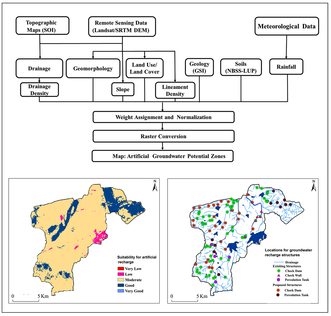
The demand for groundwater resource estimation has increased radically attributed to the growing population and rapid urbanization. To analyze the groundwater scenario the present study aims to delineate the groundwater potential zones (GWPZ’s) using the integrated remote sensing (RS) and Geographic Information System (GIS) based approach and AHP/ANP model in Western Himalaya. For the groundwater potentiality analysis, the thematic layers that were selected for the preparation of GWPZ map include lithology, Topographic Wetness Index (TWI), Topographic Position Index (TPI), slope, drainage density, lineament density, land use land cover and rainfall. The final output GWPZ map can be categorized as high (39.57%), moderate (16.23%), low (31.91%), and very low (12.29%). In light of the growing demand for groundwater, the estimated area under good groundwater capacity appears to be inadequate. As a result, the state government in general, as well as the water resources and planning departments, must develop appropriate strategies to combat the impending water scarcity. To relieve pressure on groundwater resources, the study recommends increasing the use of surface water from the sub-regional basin. With the applicability of remote sensing and GIS technology coupled the integration of AHP/ANP model the comprehensive groundwater prospecting is achieved and groundwater as quintessential resource can be harnessed and utilized as anthropogenic stresses and changing climate has accentuated the demands for water consumption.
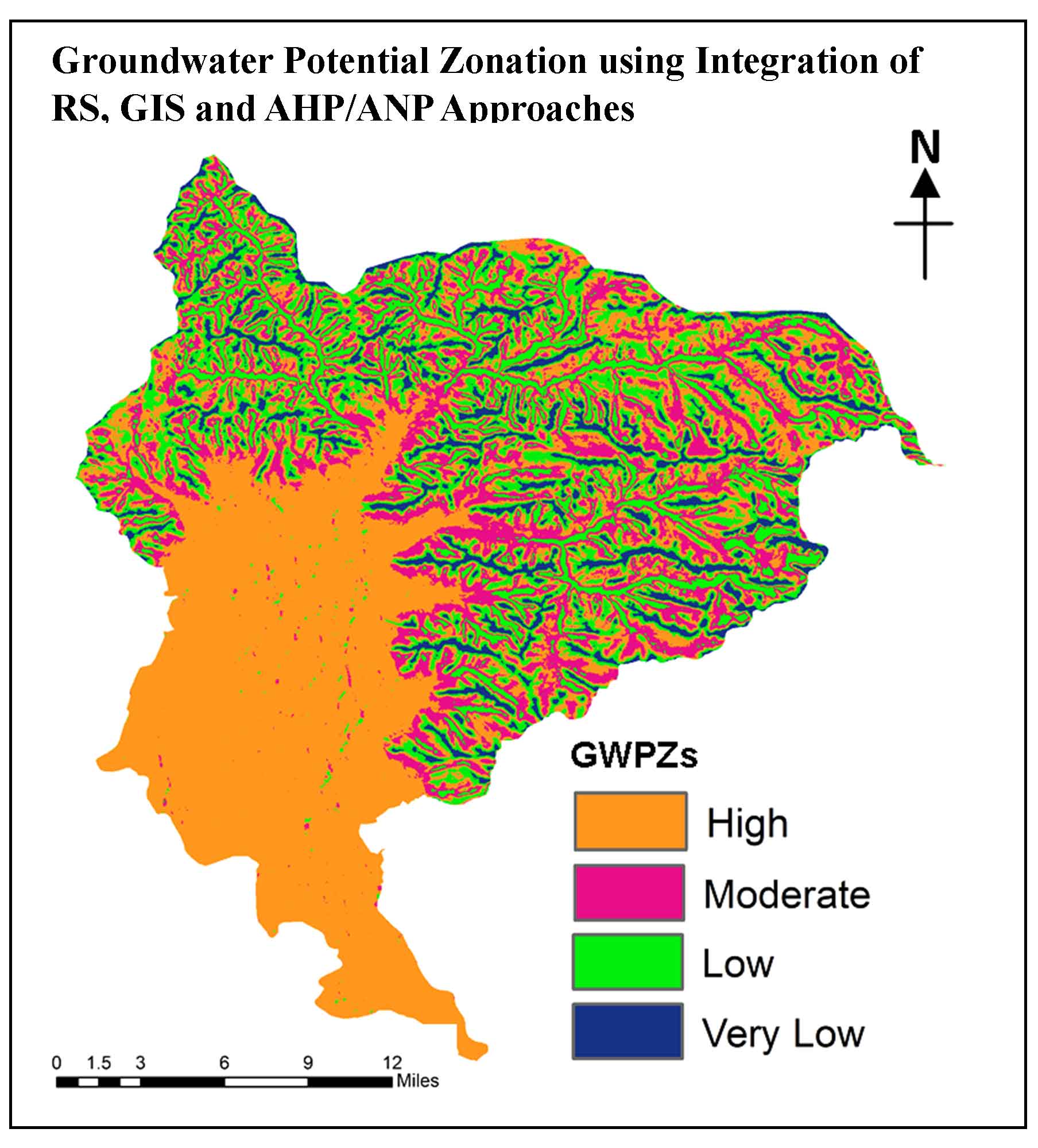
Delineation of the groundwater potential zones (GWPZ’s) using the integrated remote sensing (RS) and Geographic Information System (GIS) was based approach and AHP/ANP model in Western Himalayas.
In order to achieve the groundwater potentiality analysis the thematic layers that were selected for the preparation of GWPZ map include lithology, Topographic Wetness Index (TPI), Topographic Position Index (TPI), slope, drainage density, lineament density, rainfall and land use land cover.
The final output GWPZ map is classified into four categories, viz., very low, low, moderate and high. Results generated with these thematic layers indicate that groundwater potential zones can be categorized from the study area as moderate (28.40%) high (25.57%), low (22.67%), and very low (23.29%).
There is an urgent need for groundwater prospecting in Western Himalayas owing to its sub-surface complex formations.
Arkoprovo, B., Adarsa, J., and Prakash, S. S., 2012. Delineation of groundwater potential zones using satellite remote sensing and geographic information system techniques: A case study from Ganjam district, Orissa, India. Research Journal of Recent Sciences, 1(9), 59-66.
Jha, M. K. and Peiffer, S., 2006. Applications of remote sensing and GIS technologies in groundwater hydrology: past, present and future. BayCEER, Bayreuth, Germany, 201
Jia, Y., Zhao C. and Niu B., 2011. Application of RS and GIS technology in the study of groundwater, Groundwater J., 33, 1-3.
Kumar, A., Sharma, H. C., and Kumar, S., 2011. Planning for replenishing the depleted groundwater in upper Gangetic plains using RS and GIS. Indian Journal of Soil Conservation, 39(3), 0970-3349.
Li, J., Yang, J. and Yang, Z., et al., 2016. Extraction of underground water information at a mountainous area based on ETM images. Image Technology, J., 4, 40-44.
Ministry of Water Resources, 2009. Report of the Groundwater Resource Estimation Committee; Ministry of Water Resources, Government of India, New Delhi.
Mohammadi-Behzad, H. R., Charchi, A., Kalantari, N., Nejad, A. M. and Vardanjani, H. K., 2018. Delineation of groundwater potential zones using remote sensing (RS), geographical information system (GIS) and analytic hierarchy process (AHP) techniques: a case study in the Leylia-Keynow watershed, southwest of Iran. Carbonates Evaporites, 1-13.
NITI Aayog, 2018. India is currently suffering from the worst water crisis in its history. Composite Water Management Index (CWMI), a national tool for water measurement, management & improvement. NITI Aayog, New Delhi, Government of India. Accessed on 9 October 2020
Patra, S., Mishra, P. and Mahapatra, S. C., 2018. Delineation of groundwater potential zone for sustainable development: a case study from Ganga Alluvial Plain covering Hooghly district of India using remote sensing, geographic information system and analytic hierarchy process. J Cleaner Prod. 172, 2485-2502.
Saaty, T. L., 1980. The Analytic Hierarchy Process. McGraw-Hill, New York, NY.
Saaty, T. L., 1996. Decision making with dependence and feedback, The Analytic Network Process. RWS Publications, Pittsburgh.
Tiyip, T. and Ghulam, A., 2002. Research on model of groundwater level distribution in oasis and desert ecotone using remote sensing. Journal of Remote Sensing., 6-4, 299-306