Article Title :
Groundwater Potentiality Mapping in Viruthachalam Taluk, Tamil Nadu, India: AHP and GIS Approaches 
5 (2021)
24-33
Remote Sensing , Potential Area , IDW , Groundwater , GIS , AHP


Groundwater is the most valuable treasury commodity in the world, yet it is depleted on a daily basis. Hand arrangement is crucial in assembly for delineating a potential groundwater zones. Geographic Information System (GIS) and Remote Sensing (RS) data with Analytical Hierarchy Process (AHP) approach have proven critical for micro level analysis of groundwater potentials. This exploration was authorized in order to locate a prospective groundwater area in the Virutachalam Taluk of Southern India. The Inverse Distance Weightage (IDW) technique was used to determine the groundwater potential precinct by thematic layers of drainage, drainage density, geology, lineament, lineament density, geomorphology, soil, and slopes. Overall, the prospective groundwater zone in the study area was classified as excellent (20.66 %), good (60.29 %), moderate (16.38 %) and poor (2.73 %). This optional analysis offers an excellent possible groundwater zone for patches in the northern and central sections of Kotteri and Kammapuram in Virudhachalam Taluk. The survey revealed that the approach of inverse distance weighting provides an operating mechanism for suggesting groundwater potential zones for clear expansion and groundwater control in not the same hydro-geological settings.
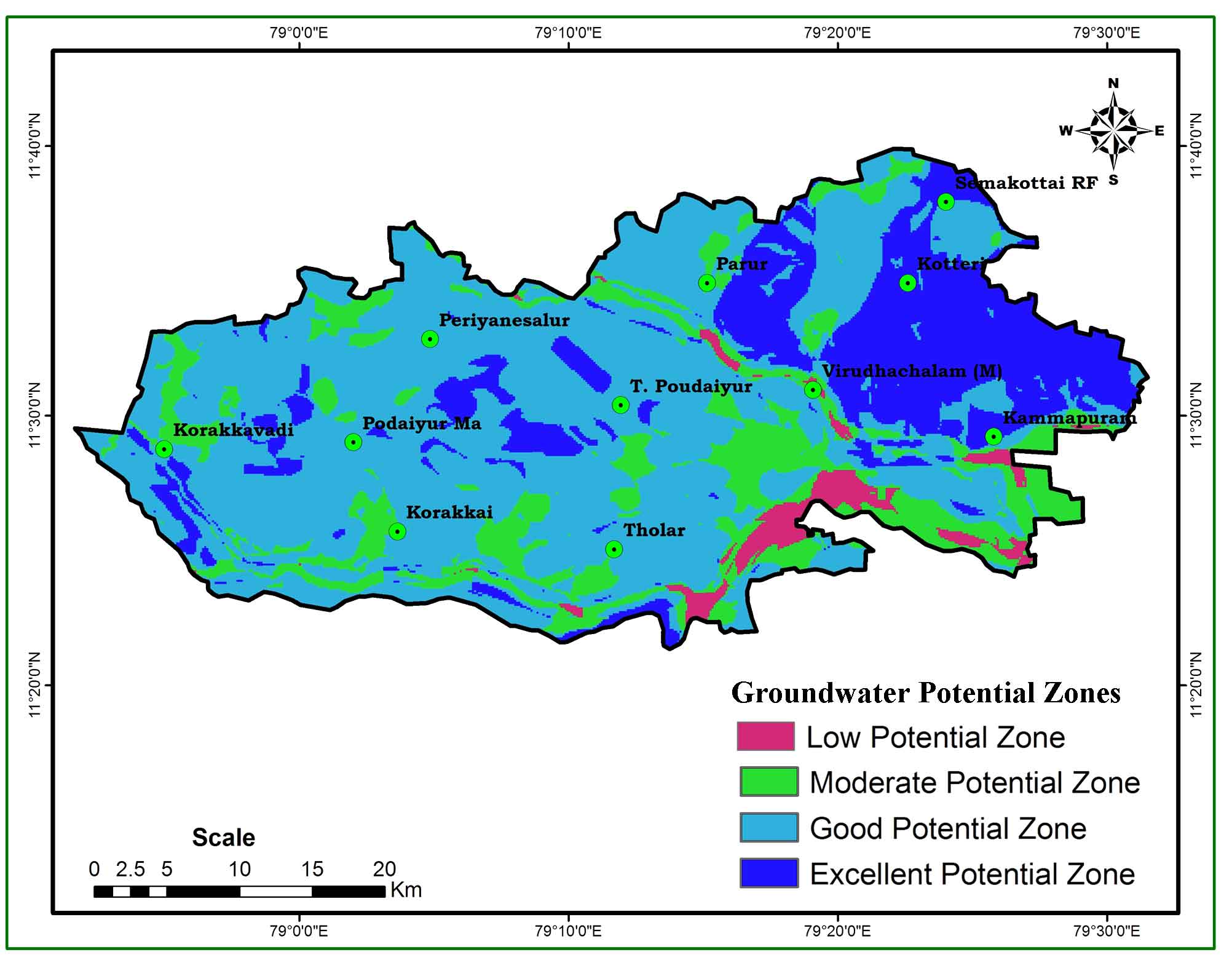
GIS and Remote sensing technology with AHP approach was used to locate a prospective groundwater areas.
Inverse Distance Weightage (IDW) technique was used to determine the groundwater potential precinct.
An excellent possible groundwater zone for patches in the northern and central sections of Kotteri and Kammapuram in Virudhachalam Taluk.
The mechanism is suggesting groundwater potential zones for expansion and groundwater control.
Goodchild, M. F., 1993. The state of GIS for environmental problem solving. In: Goodchild M. F., Parks B. O., Steyaert L. T. (Ed.) Environmental modeling with GIS. Oxford University Press, New York, 8-15.
Haridas, V. R., Aravindan, S. and Girish, G., 1998. Remote sensing and its applications for groundwater favourable area identiûcation. Quart. Jour. GARC, 6, 18-22.
Harinarayana, P., Gopalakrishna, G. S. and Balasubramanian, A., 2000. Remote sensing data for groundwater development and management in Keralapura watersheds of Cauvery basin, Karnataka, India. Indian Mineralogists, 34, 11-17.
Hinton, J. C., 1996. GIS and remote sensing integration for environmental applications. Geographical Information Systems, 10(7), 877-890.
Horton, E., 1932. Drainage-basin characteristics. Eos, Transactions American Geophysical Union, 13(1), 350-361.
Leblanc, M., Leduc, C., Razack, M., Lemoalle, J., Dagorne, D. and Mofor, L., 2003. Application of remote sensing and GIS for groundwater modeling of large semiarid areas: example of the Lake Chad Basin, Africa. In: Hydrology of Mediterranean and Semiarid Regions Conference, Montpieller, France. Red Books Series, 278. IAHS, Wallingford, 186192.
Mohammadi-Behzad, H. R., Charchi, A., Kalantari, N., Nejad A. M. and Vardanjani, H. K., 2019. Delineation of groundwater potential zones using remote sensing (RS), geographical information system (GIS) and analytic hierarchy process (AHP) techniques: a case study in the Leylia-Keynow watershed, southwest of Iran. Carbonates and Evaporites, 34, 1307-1319.
Patra, S., Mishra, P. and Mahapatra, S. C., 2018. Delineation of groundwater potential zone for sustainable development: A case study from Ganga Alluvial Plain covering Hooghly district of India using remote sensing, geographic information system and analytic hierarchy process. Journal of Cleaner Production, 172, 2485-2502.
Saaty, T. L., 1990. Decision making for leaders: The analytic hierarchy process for decisions in a complex world. RWS publications.
Singh, A. K. and Prakash, S. R., 2003. An integrated approach of remote sensing, geophysics and GIS to evaluation of groundwater potentiality of Ojhala subwatershed, Mirzapur district, UP, India. Map India conference.
Thomas, A., Sharma, P. K., Sharma, M. K and Sood A., 1999. Hydrogeomorphological mapping in assessing groundwater by using remote sensing datada case study in Lehra Gage Block, Sangrur district, Punjab. Jour. Indian Soc. Remote Sensing, 27, 31-42.