Toggle navigation
Online Platform
Manuscript Portal
®
Register
Sign In
()
Logout
Gatha Cognition
®
Perception, Learning and Reasoning
All
Authors
Journals
Books
Articles
Chapter
Bookstore
Toggle navigation
Home
(current)
About Us
Journals
e-Books
Book Store
Services
Contact
Cart (0)
0
Total:
0
Checkout
Scholar Profile
Dr. Murugesan Bagyaraj
Assistant Professor
Department of Geology, College of Natural and Computational Sciences, Debre Berhan University, Debre Berhan, Ethiopia.
Contact
Authorship
Articles (5)
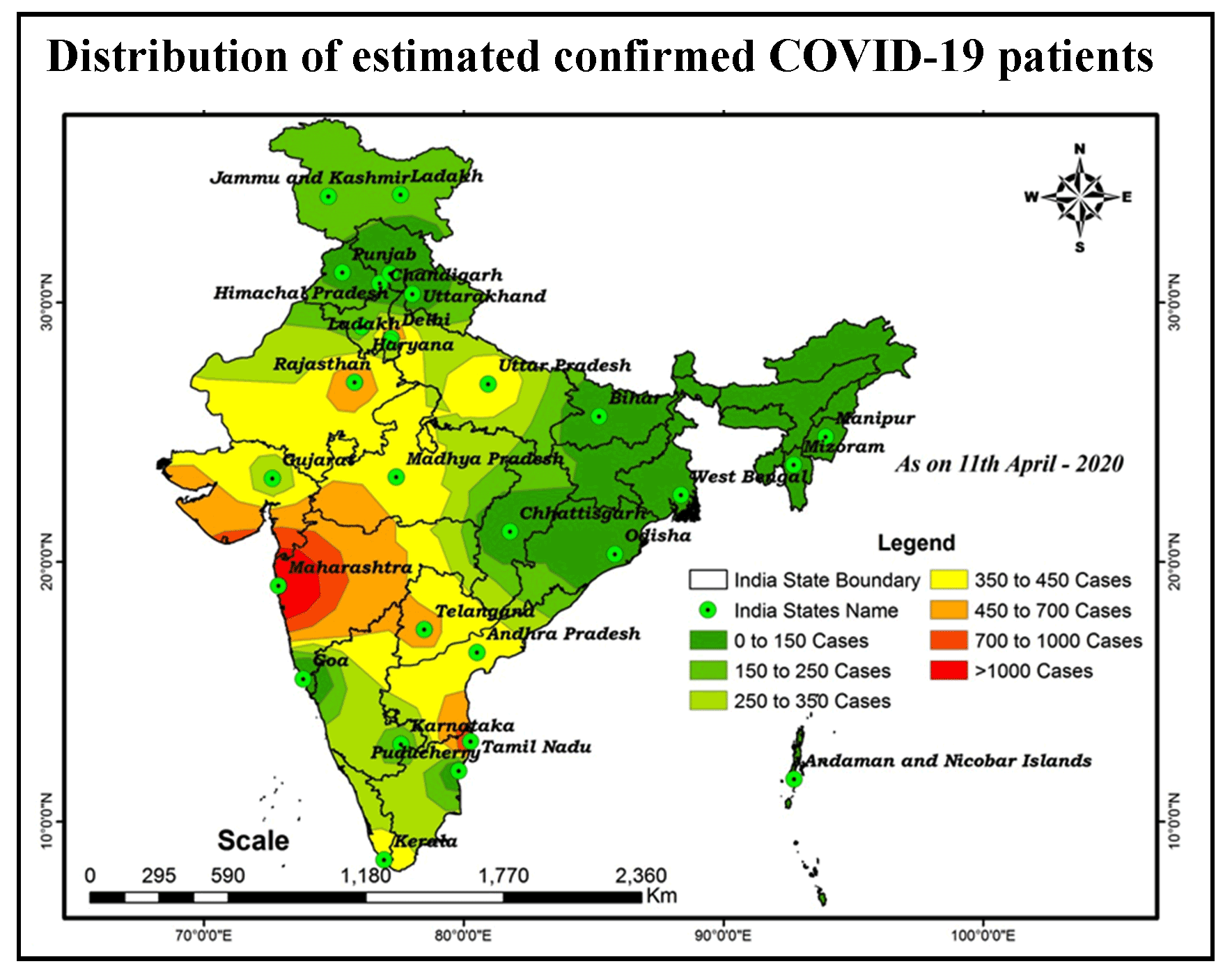
Distribution and Trend Analysis of COVID-19 in India: Geospatial Approach
Author(s) :
Murugesan Bagyaraj
SHANKAR KARUPPANNAN
Alemayehu Tenaw Mengistie
Gnanachandrasamy Gopalakrishnan
Pages :
1-9
DOI :
https://doi.org/10.21523/gcj5.20040101
Keywords :
Spatial Distribution,India,GIS,COVID-19,Coronavirus
Abstract
Graphical Abstract
Highlights
Full Text
e-Print
Recommend
Cited By
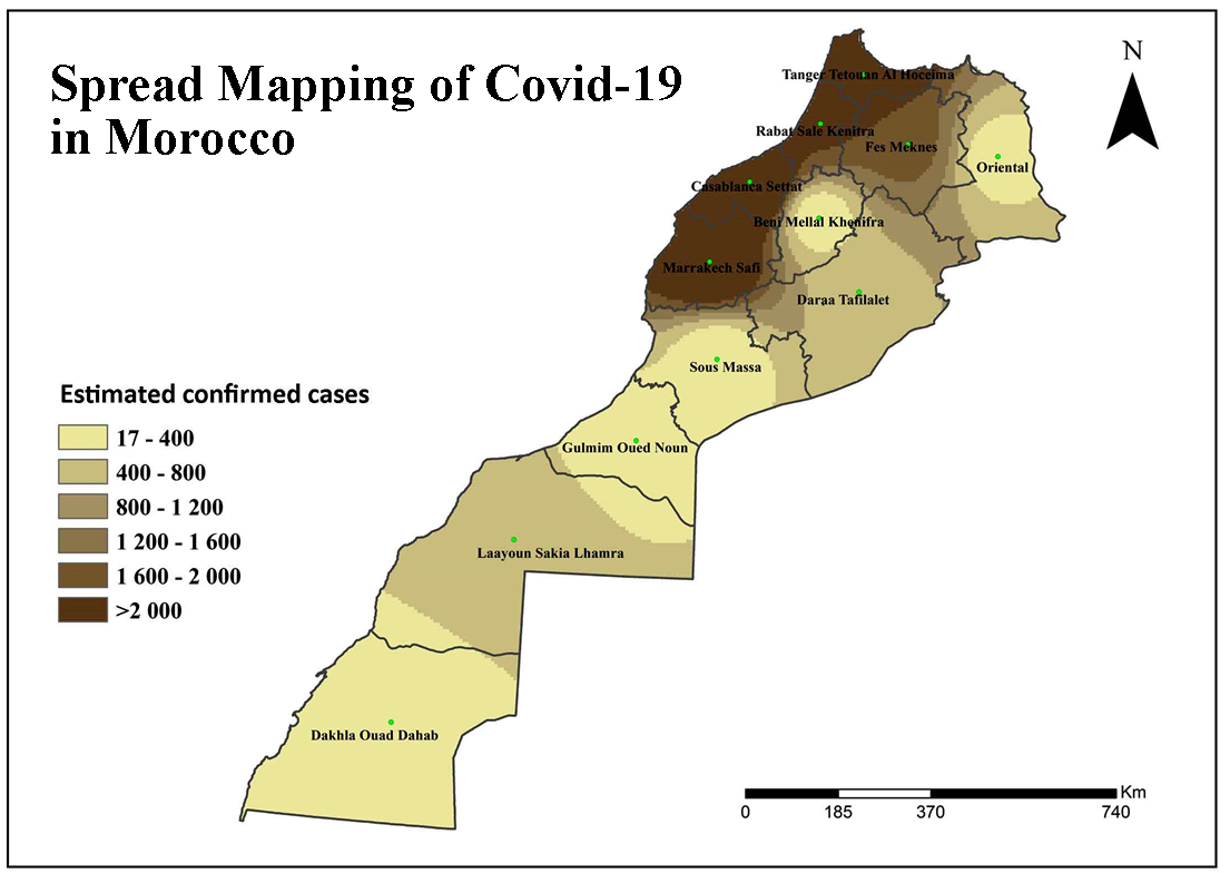
Spread Mapping of Covid-19 in Morocco Using Geospatial Approach
Author(s) :
Elhoucein LAYATI
Abdellah Ouigmane
Marcelo de Carvalho Alves
Murugesan Bagyaraj
Mohamed ELGHACHI
Pages :
35-43
DOI :
https://doi.org/10.21523/gcj5.20040104
Keywords :
COVID-19,GIS,Inverse Distance Weighted (IDW),Morocco,Spatial Distribution
Abstract
Graphical Abstract
Highlights
Full Text
e-Print
Recommend
Cited By
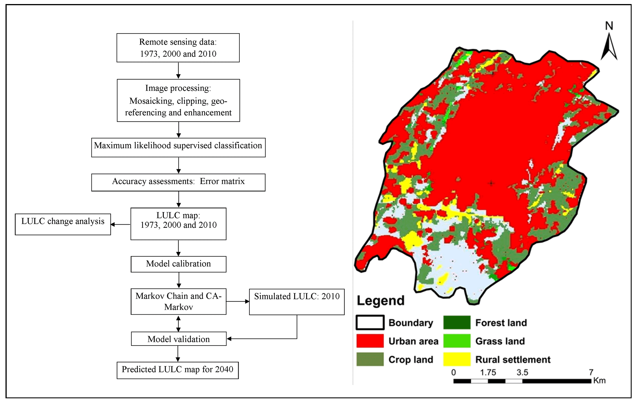
Analysis of Urban Expansion and Modeling of LULC Changes Using Geospatial Techniques: The Case of Adama City
Author(s) :
Bedasa Regassa
Mikir Kassaw
Murugesan Bagyaraj
Pages :
40-58
DOI :
https://doi.org/10.21523/gcj1.20040104
Keywords :
Cellular Automata,GIS,Image Classification,LULC,Markov Chain,Modeling,Remote Sensing
Abstract
Graphical Abstract
Highlights
Full Text
e-Print
Recommend
Cited By
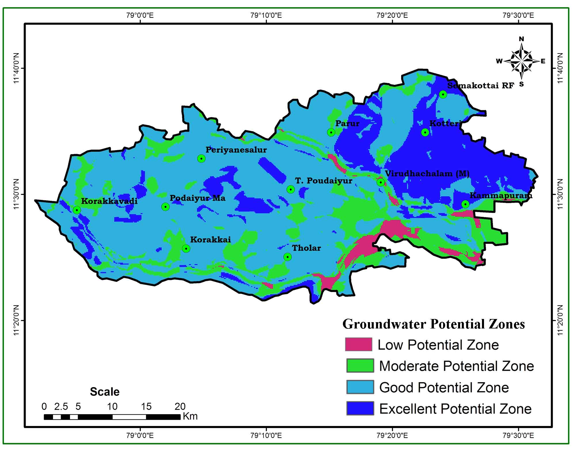
Groundwater Potentiality Mapping in Viruthachalam Taluk, Tamil Nadu, India: AHP and GIS Approaches
Author(s) :
Murugesan Bagyaraj
Mukesh M
Zubairul Islam
Daniel Tekley Gebremedhin
Grmay Kassa Brhane
Pages :
24-33
DOI :
https://doi.org/10.21523/gcj3.2021050103
Keywords :
Remote Sensing,Potential Area,IDW ,Groundwater,GIS,AHP
Abstract
Graphical Abstract
Highlights
Full Text
e-Print
Recommend
Cited By
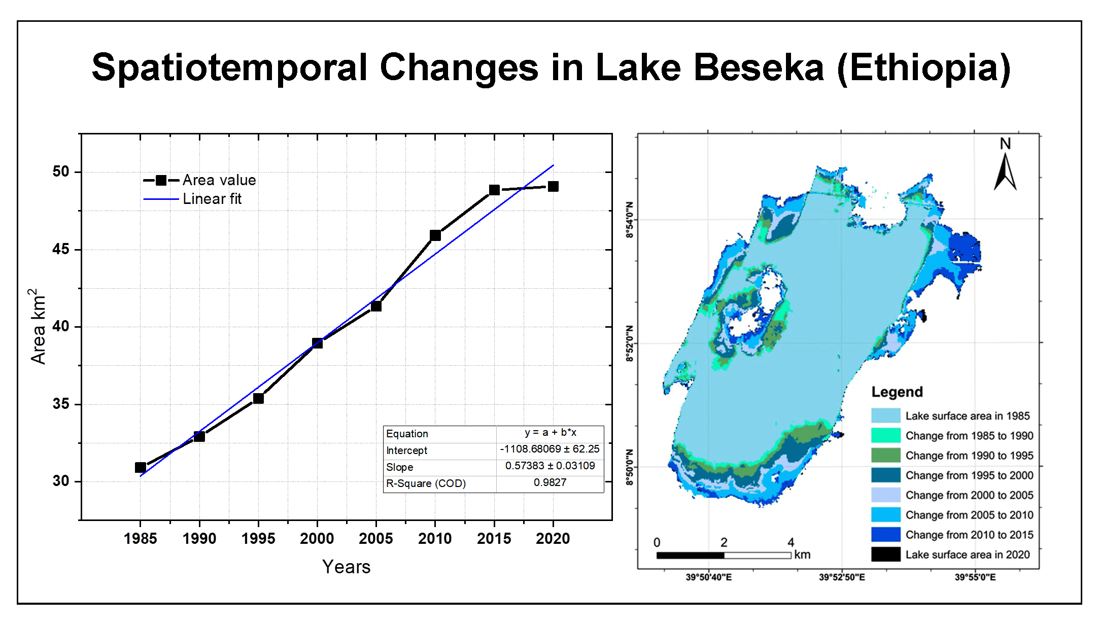
Spatiotemporal Change Assessment of Lake Beseka, Ethiopia Using Time Series Landsat Images
Author(s) :
Tewabe Melkamu
Murugesan Bagyaraj
Melkamu Adimaw
Pages :
27-39
DOI :
https://doi.org/10.21523/gcj3.2022060103
Keywords :
Water index,Surface area,Landsat,Lake Beseka,Change Detection
Abstract
Graphical Abstract
Highlights
Full Text
e-Print
Recommend
Cited By
Reviewership
Journals (3)
Remote Sensing of Land
DOI :
dx.doi.org/10.21523/gcj1
From :
31 May 2021
Hydrospatial Analysis
DOI :
https://doi.org/10.21523/gcj3
From :
20 Nov 2020
Journal of Geographical Studies
DOI :
http://dx.doi.org/10.21523/gcj5
From :
21 Apr 2020
Books (0)
×
Contact to Author
Are you sure decline this record ?
.