Article Title :
Multi-criteria Land Suitability Analysis for Agriculture in Semi-Arid Region of Kadapa District, Southern India: Geospatial Approaches 

5 (2021)
59-72
Agriculture , AHP , GIS , Land Suitability , Remote Sensing


This research proposes an integrated methodology for incorporating RS, GIS and AHP techniques for the assessment of agricultural land suitability. In Kadapa district, Andhra Pradesh, India, study is being done on how to best promote agriculture as a source of income to boost the economy of the region. A combined RS, GIS and AHP techniques has been utilized that incorporates organizing AHP hierarchy, criteria specification, pairwise comparison, and criterion map preparation. Land suitability comparison showed that an area of 4.42 km2 (2.62%) is appropriate for irrigation, while an area of 54.39 km2 (32.33%) is appropriate moderately suitable for rainfed agriculture and 95.76 km2 (56.93%) is marginally suitable for agricultural productions. About 13.64 km2 (8.11%) land is currently not suitable for agricultural production. Additionally, the analysis clearly shows the necessity of a decrease in irrigated agricultural land and an increase in dry farm agricultural land. This application of RS, GIS and AHP based agricultural land suitability analysis is helpful in referring agricultural activities to the areas with good physical and environmental conditions, allowing maximum agricultural efficiency in the countryside, increasing non-agricultural uses in areas with low efficiency, and avoiding the construction and environmental pressures on suitable farmland.
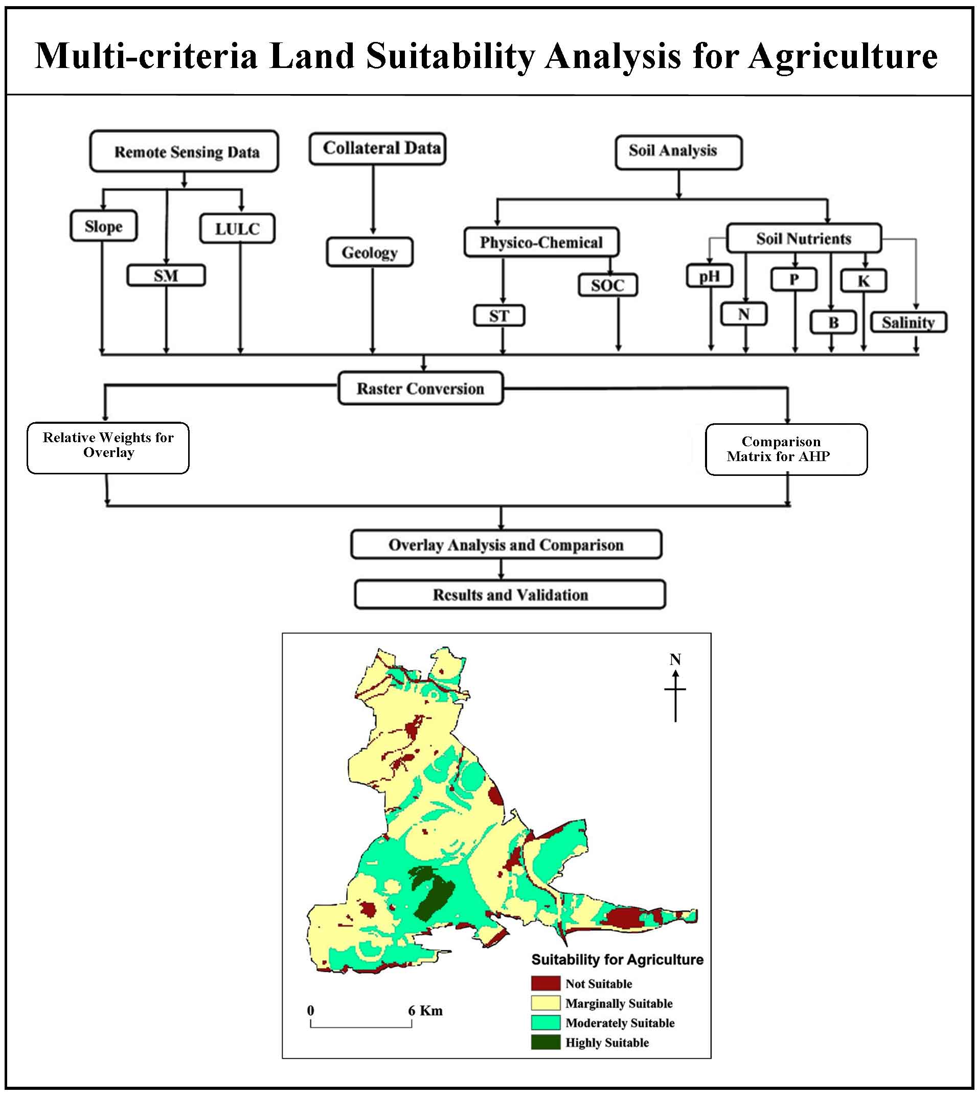
RS, GIS and AHP were used to assess land suitability for Agriculture production.
Assigned scores of sub-criterions were based on literature survey and field work.
About 2.62% of the research area was found highly suitable for agricultural production.
Integrated RS, GIS and AHP approaches were found effective in assessing the land suitability.
GSI [Geological Survey of India], 2002. District Mineral Resources Map, Anantapur, Andhra Pradesh, India.
IMSD [Integrated Mission for Sustainable Development], 1995. Integrated mission for sustainable development technical guidelines.
Kadam, A., Rajasekhar, M., Umrikar, B., Bhagat, V., Sankua, R. N. and Perspective, R., 2020. Land suitability analysis for afforestation in semi-arid watershed of western Ghat, India : A groundwater recharge perspective land suitability analysis for afforestation in semi-arid watershed of western. Geology, Ecology, and Landscapes, 5(2), 136-148.
Prakash, T. N., 2003. Land suitability analysis for agricultural crops using multi-criteria decision making and GIS approach. Journal of Agrometeorology, 1-57.
Rajasekhar, M., Gadhiraju, S. R., Kadam, A. and Bhagat, V., 2020. Identification of groundwater recharge-based potential rainwater harvesting sites for sustainable development of a semiarid region of southern India using geospatial, AHP, and SCS-CN approach. Arabian Journal of Geosciences, 13(2), 24.
Rajasekhar, M., Sudarsana Raju, G., Siddi Raju, R. and Imran Basha U., 2017. Landuse and landcover analysis using remote sensing and GIS: A case study in Uravakonda, Anantapur District, Andhra Pradesh, India. International Research Journal of Engineering and Technology (IRJET), 4(9), 780-785
Saaty, T. L., 1980. The analytic hierarchy process. New York: McGraw-Hill.
Selvarani, A. G., Maheswaran, G. and Kumar, C. S., 2016. Asian research consortium demarcation of groundwater feasible region using GIS and fuzzy logic. Asian Journal of Research in Social Sciences and Humanities, 6(7), 276-280.
Tseganeh, B., Sehra, P. S. and Sood, A., 2008. Land suitability analysis for agricultural crops using GIS and remote sensing techniques. Journal of Agrometeorology, (SPECIAL ISSUE 1), 67-71.