

Article Title :
Geoelectrical Survey for Evaluation of Groundwater Potential Within the Basaltic Terrain of Chikotra River Basin, Maharashtra (India) 
5 (2021)
72-84
Resistivity , Maharashtra , Inverse Distance Weighted , Groundwater , Chikotra River


Geoelectrical data was acquired using Wenner array over 23 sites with constant electrode separation of 70 m over Chikotra Basin, Dist. Kolhapur, Maharashtra (India). The spatial variation maps of resistivity at depths from 2 to 70 m were plotted using Inverse Distance Weighted (IDW) technique for interpolation in ArcGIS 10.5 to obtain a comprehensive subsurface hydrogeological representation of the study area. High resistivity (>140 Ωm) up to 20m depth, indicative of massive basalts is deciphered towards the NE part of the study area, while the NW sector reveal low resistive (up to 40 Ωm) feature at shallow depths due to fractured basalts, thus conducive for groundwater exploration. Alluvium deposits and columnar jointed basalts in the central part depicts as EW trending conductive (< 30 Ωm) feature suggesting prospective groundwater zone. Low resistivity (6-50 Ωm) from shallow to deeper depths (up to 70m), in the southern region can be identified as potential aquifer system. Longitudinal geoelectric cross-sections are generated over four profiles to identify the lateral and vertical variation in geology and groundwater potential zones. The western and central part of the northern profile (A-A') is highly resistive with resistivity of the order of 80-140 Ωm constituting compact basalts and thus devoid of water. Low resistive zone (30 Ωm) in the eastern part suggests groundwater at shallow depths. Low resistivity zones ranging from 10-50 Ωm is observed at different depth levels over the central profile (B-B') which can be tapped for groundwater exploitation. Several sites over profiles C-C' and the southern-most D-D' suggest promising aquifer zones. Because defining prospective groundwater zones in hard rock terrain is difficult, it’s crucial to look into a river basin’s hydrogeological arrangement early on in the planning process.
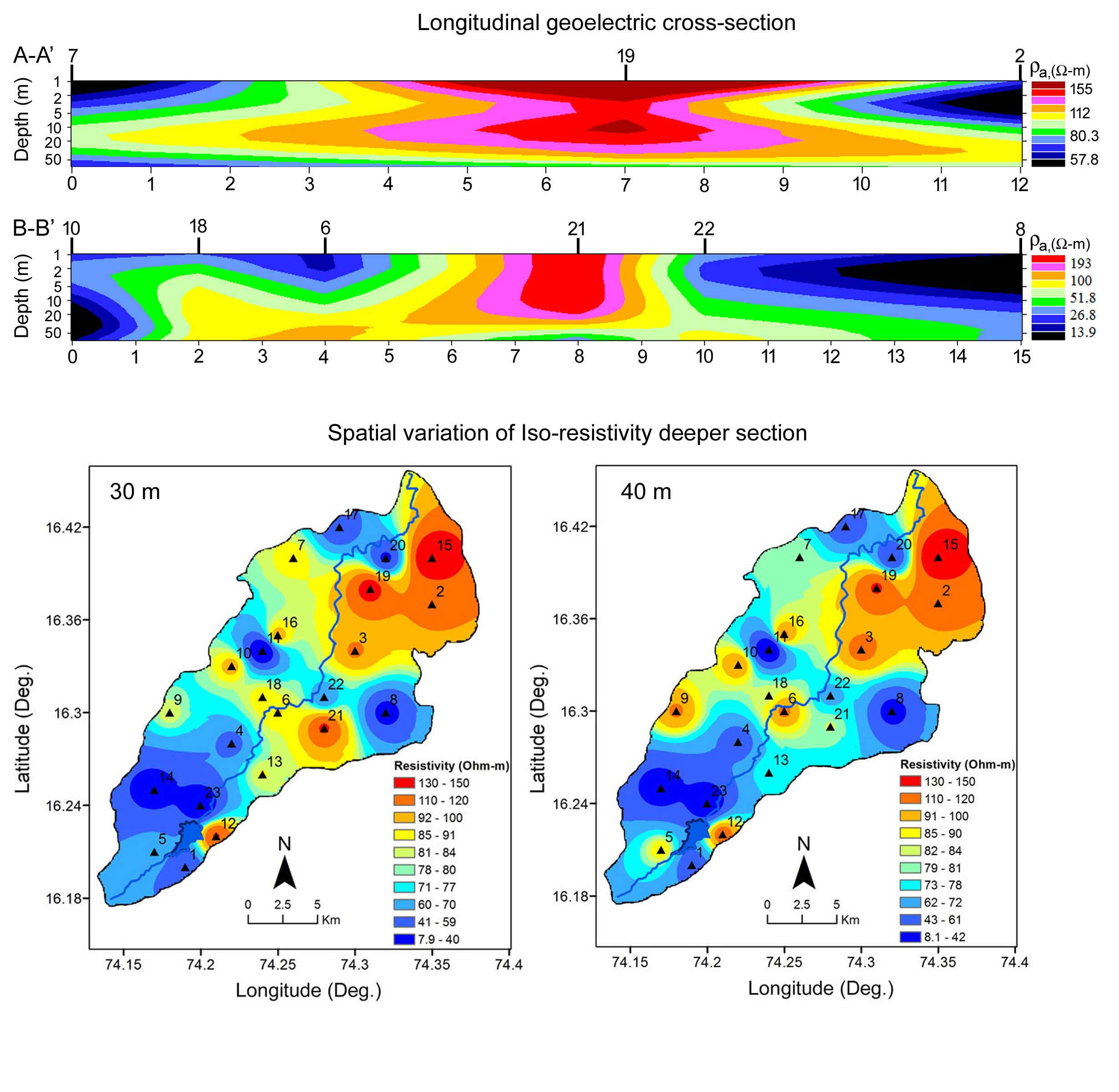
Hard rock Chikotra Basin, surveyed by Wenner array over 23 sites.
Iso-resistivity plotted by ArcGIS 10.5 to prospect groundwater zone.
Spatial variation at all depths plotted using IDW scheme.
High resistivity in NE of study area indicates massive basalts.
Longitudinal geoelectric cross-sections corroborate with spatial variation maps.
Alluvium and columnar jointed basalts are conducive for groundwater.
Adejumo, S. A, Oyerinde, A. O. and Aleem, M. O., 2015. Integrated geophysical and geotechnical subsoil evaluation for pre-foundation study of proposed site of Vocational Skill and Entrepreneurship Center at The Polytechnic, Ibadan, SW, Nigeria. International Journal of Science and Engineering Research, 6(6), 910-917.
Adeoti, L., Alile, O. M. and Uchegbulam, O., 2010. Geophysical investigation of saline water intrusion into freshwater aquifers: A case study of Oniru, Lagos State. Scientific Research and Essays, 5(3), 248-259.
Bobachev, A., 2003. Resistivity sounding interpretation. IPI2WIN: Version 3.0.1, a 7.01.03; Moscow State University.
Burrough, P. A. and McDonnell, R. A., 1998. Principles of Geographical Information Systems, second ed. Clarendon Press, Oxford.
Deshpande, G. G., 1998. Geology of Maharashtra. Geological Society of India, Bangalore.
Gómez-Puentes, F. J., Pérez-Flores, M. A., Reyes-López, J. A., Lopez, D. L., Herrera-Barrientos, F., García-Cueto, R. O., Romero-Hernández, S., Solís-Domínguez, F. A. and Martín-Loeches-Garrido, M., 2016. Geochemical modeling and low-frequency geoelectrical methods to evaluate the impact of an open dump in arid and deltaic environments. Environmental Earth Science, 75, 1062.
Gupta, S., 2013. Groundwater information, Kolhapur district, Maharashtra. Technical Report No. 1811/DBR/2010, Ministry of Water Resources, Central Groundwater Board, Govt. of India.
Keller, G.V. and Frischknecht, F.C., 1966. Electrical methods in geophysical prospecting, Pergamon Press Inc., Oxford.
Mungale, S., 2001. Geology of the Chikotra River basin District Kolhapur with special reference to watershed development. Unpublished M.Sc. Dissertation, Pune University, Pune, 63.
Pawar, N. J., Pawar, J. B., Supekar, A., Karmalkar, N. R., Kumar, S. and Erram, V. C., 2009. Deccan dykes as discrete and prospective aquifers in parts of Narmada-Tapi Zone, Dhule district, Maharashtra. In: Srivastava, R. K., Sivaji, C., Chalapathi Rao, N. V. (Eds) Indian Dykes: Geochemistry, Geophysics and Geochronology. Narosa Publishing House Pvt. Ltd., New Delhi, 189-198.
Singhal, B. B. S., 1997. Hydrogeological characteristics of Deccan trap formations of India. Proceedings Hard Rock Hydrosysteins (Rabat Symposium S2, May 1997), IAHS Publ. 241.
Tahama, K., Gupta, G. and Krishnamacharyulu, S. K. G., 2018. Geoelectrical studies to understand the groundwater regime in parts of coastal area of Sindhudurg district, Maharashtra, India. International Journal of Earth Science and Engineering, 11(2), 194-199.

