

Article Title :
Geospatial Mapping and Accessibility Analysis of Eye Health Facilities: A Case Study of Dhaka City Corporation 
Mazed Parvez
 ,
A H Md Mahabub Nawaz
,
Faisal M Ahamed
,
Syed Tanim Ahmed
,
Laila Begum
,
Fazle Rabby
,
Nawal Sarwer
,
A H Md Mahabub Nawaz
,
Faisal M Ahamed
,
Syed Tanim Ahmed
,
Laila Begum
,
Fazle Rabby
,
Nawal Sarwer
9 (2025)
56-68
Average nearest neighbor , Eye care , GIS , Healthcare facility , Public Health


Access to quality eye care is vital for public health, yet in Bangladesh, it is hindered by inadequate infrastructure, limited facilities, and insufficiently trained personnel. This study examines the accessibility and spatial distribution of eye health services in Dhaka City Corporation using Geographic Information Systems (GIS), Eight Key Informant Interviews (KIIs), and Six Focus Group Discussions (FGDs). GIS analysis revealed that only 14% of the city is adequately served, 45% is overserved, and 41% is underserved. The Average Nearest Neighbour (ANN) analysis indicated a significantly dispersed pattern (ANN ratio = 3.34; z-score = 20.49; p < 0.001). Key challenges include financial constraints (66.7% of respondents), poor accessibility for people with disabilities, transportation barriers, and lack of service information. While 68.8% of participants were satisfied with services and gender parity was noted, gaps in coverage and consistency persist. The findings call for equitable distribution of resources, mobile outreach, and improved affordability.
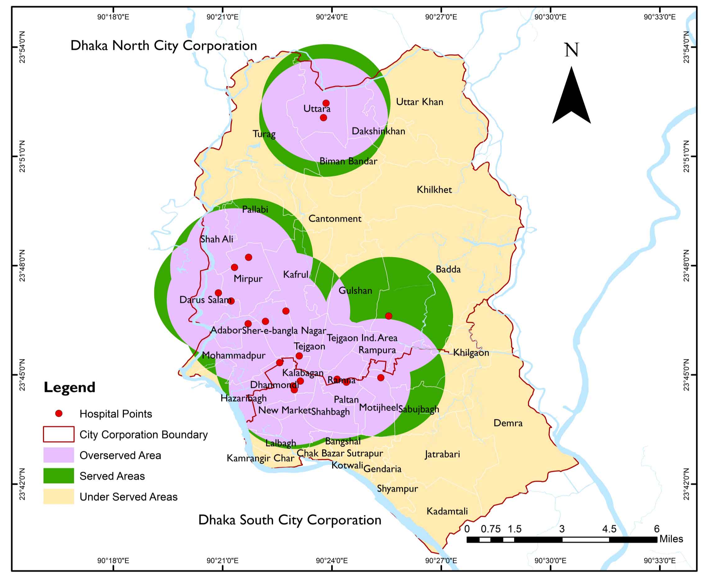
Only 14% of Dhaka City is adequately served regarding eye care hospitals, while 45% is overserved and 41% underserved, showing poor resource distribution.
ANN ratio 3.34 confirms facilities are widely dispersed, increasing travel time and delaying access.
About 66.7% face financial barriers, the highest among low-income households (<10,000 BDT/month).
People with disabilities and slum dwellers face significant access challenges due to poor infrastructure, transport, and a lack of information.
Dhaka North is overserved, while Dhaka South is underserved, especially in dense peripheral areas.
Anderson, A. and Smith, T., 2020. Geospatial mapping of eye health facilities and service coverage in a targeted region of Bangladesh. Journal of Health and Medical Geography, 12(1), 56-68.
Bourne, R. R., Steinmetz, J. D., Flaxman, S., Briant, P. S., Taylor, H. R., Resnikoff, S., Silvester, A., Stevens, G. A., Tahhan, N., Wong, T., Taylor, H. R. and Vision Loss Expert Group., 2017. Magnitude, temporal trends, and projections of the global prevalence of blindness and distance and near vision impairment: A systematic review and meta-analysis. The Lancet Global Health, 5(9), e888-e897.
Brown, P. and Lee, S., 2022. Using geographic information systems (GIS) in healthcare facility mapping: A Review of Methodologies and Applications. Health Services Research Journal, 28(4), 311-330.
Davis, R. L. and Martinez, P. C., 2019. Spatial analysis of eye care services in urban and rural areas: Implications for policy and planning in Bangladesh. Health Policy and Planning, 34(5), 321-335.
Garcia, M. S. and Jackson, R. L., 2020. Analyzing healthcare accessibility in rural areas: A GIS-based approach. International Journal of Health Geographics, 19(1), 45.
Ichhpujani, P., Thakur, S. and Sahi, R. K., 2022. Addressing disparities in eye care: A global call to action. Journal of Optometry, 15(1), 10-18.
Islam, F., Tariq, A., Rufat Guluzade, Zhao, N., Shah, S. U., Ullah, M., Hussain, M.L., Ahmad, M. N, Icon, A. A., Alzuaibr, F. M., Askary, A. and Aslam, M., 2023. Comparative analysis of GIS and RS based models for delineation of groundwater potential zone mapping. Geomatics Natural Hazards and Risk, 14(1).
Johnson, E. R. and Anderson, B. W., 2017. Assessing the spatial distribution of eye health facilities in Bangladesh: A GIS-Based Study. International Journal of Health Planning and Management, 32(4), 450-468.
Kim, S. H. and Gupta, N., 2018. Evaluating accessibility and equity in eye care services: A GIS-based assessment in Dhaka City. Health and Place, 24, 160-167.
Kuran, C. H. A., Morsut, C., Kruke, B. I., Krüger, M., Segnestam, L., Orru, K., Nævestad, T. O., Airola, M., Keränen, J., Gabel, F., Hansson, S. and Torpan, S., 2020. Vulnerability and vulnerable groups from an intersectionality perspective. International Journal of Disaster Risk Reduction, 50(101826), 101826.
Liu, X. and Wang, Y., 2018. Mapping healthcare facilities using GIS for improved access to eye care services: Lessons from Bangladesh. Geospatial Health, 13(2), 235-247.
Patel, A. B. and Jones, C. D., 2019. Geospatial analysis of healthcare disparities: A case study of eye care services in Bangladesh. Journal of Global Health, 7(2), 85-96.
Rodriguez, M. and Williams, K., 2021. Assessing geographic disparities in eye health services: A case study of Moulvibazar and Mymensingh Sadar. Geospatial Health Research, 9(3), 198-213.
Smith, J. A. and Johnson, L. M., 2021. Geospatial mapping and accessibility analysis of health facilities in a Targeted region: A Comprehensive Study. Journal of Healthcare Geography, 15(3), 225-243.
Wang, L., Li, X. and Li, J., 2017. A review of spatial analysis of ecological data in GIS and its application. Ecological Modelling, 222, 189-197.

