Article Title :
Multi-Criteria Land Suitability Analysis for Plantation in Upper Mula and Pravara Basin: Remote Sensing and GIS Approach 
2 (2018)
12-21
Land Suitability , Plantation , Analytic Hierarchy Process , Weighted overlay analysis , AHP , Plantation


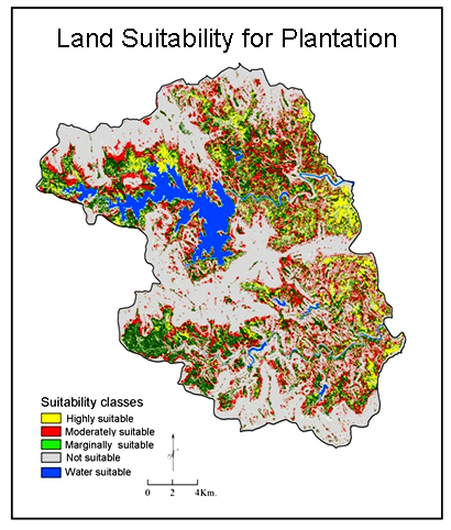
Assessment of land suitability potentials is an important step to detect the environmental limit for sustainable land management (SLM). Land suitability analysis (LSA) is more suitable, beneficial and environmentally acceptable for SLM. It deals with the assessment of land performances for the specific use like agriculture, plantation, etc. The main objective of the present study was to determine the suitable areas for plantation in the Upper Mula and Pravara Basin. GIS based Analytic Hierarchy Process (AHP) was used to analyze land suitability for plantation. Criterion like slope, LULC, depth, texture, moisture, SOC, MWHC, pH, EC and primary nutrients were used. Pairwise comparison matrix was used for calculation of weights for criterion and scores were assigned to sub-criterion using field work, experts’ opinions and literature review. Weighted overlay analysis was used for final output raster map. Then cell values of raster map were divided into four classes i.e. 9, 7, 4 and 1. Finally, these classes have reclassified into four suitability levels according to FAO. About 5% of reviewed land is highly suitable, 23% moderately suitable, 14% marginally suitable and 58% not suitable for plantation in the region.

AHP based multi-criteria land suitability analysis (LSA) is useful for planning for sustainable development of barren lands.
High resolution IRS P6 LISS-IV satellite datasets were used for LSA.
Pairwise comparison matrix was used for calculation of weights for criterion.
Score values were assigned to sub-criterion using field work, experts’ opinions and literature review.
Weighted overlay analysis was used for final output raster map.
Land is classified into: highly suitable, moderately suitable, marginally suitable and not suitable for plantation in the region.
Bhagat, V. S., 2013. Use of remote sensing techniques for robust detection and estimations of soil organic carbon: A review. Recent Progress in Space Technology, 3, 83-102.
Dumanski, J., 1997. Criteria and indicators for land quality and sustainable land management. ITC Journal, 3(4), 216-222.
FAO, 1976. A framework for land evaluation, Soil Bulletin 32. Food and Agriculture Organization of the United Nations, Rome, Italy.
FAO, 1995. Planning for sustainable use of land resources: Towards a new approach. FAO Land and Water 2, Rome.
FAO, 1999. The state of food insecurity on the world. FAO, Rome.
FAO, WFP and IFAD. 2012. The state of food insecurity in the World 2012. Economic growth is necessary but not sufficient to accelerate reduction of hunger and malnutrition. Rome, Italy.
Kuria, D., Ngari, D. and Withaka, E., 2011. Using geographic information systems (GIS) to determine land suitability for rice crop growing in the Tana delta. Journal of Geography and Regional Planning, 4(9), 525-532.
Malczewski, J., 1999. GIS and multi-criteriadecision analysis. John Wiley and Sons Inc., New York.
Mojid, M. A., Mustafa, S. M. T. and Wyseure, G. C. L., 2009. Growth, yield and water use efficiency of wheat in silt loam-amended loamy sand. Journal of the Bangladesh Agricultural University, 7(2), 403-410.
Saaty, T. L., 1980. The Analytic Hierarchy Process: Planning, Priority Setting, Resource Allocation. McGraw Hill International, New York, NY, USA.
Speth, J. G., 1993. Towards sustainable food security. Sir John Crawford Memorial Lecture to the Consultative Group on International Agricultural Research 25.
Zolekar, R. B., 2016. Land suitability analysis using remote Sensing and GIS: A case study of upper Mula and Pravara basin. Ph. D thesis submitted to Savitribai Phule Pune University.


