
Journal Open access Double-blind peer review
Journal of Geographical Studies
In association with the Department of Geography, Jamia Millia Islamia (A Central University), New Delhi
'Journal of Geographical Studies' (JGS) publishes double-blind peer-reviewed articles within all fields of geography.
Editor-in-Chief Professor. Masood Ahsan Siddiqui (Department of Geography, Jamia Millia Islamia – A Central University, New Delhi-110025 (India).)
Managing Editor Dr. Kalpana Bhagat  (Gatha Cognition.)
- Articles published
- 59
- Crossref citations
- 277
- Citation ratio · Crossref
- 4.69
- Citation ratio · OpenAlex
- 7.37
- Days to first decision
- 124
Citation ratio = citations ÷ all articles published since the first issue. Days to first decision = median days from submission to the editor’s first decision, for the last 20 manuscripts (submitted since April 2023).
Issue
Volume 2 (2018) · Issue 1
Original Research Paper
-
pp. 1-11 Open access
Appraisal of Heavy Metals in Soil/Sediments with Relation to their Physicochemical Properties from Ankaleshwar Industrial Area South Gujarat
Krushnath D Shirke, N. J. Pawar
Extensive industrialization in the southern part of Gujarat is characterized by regional pollution of soil and water resources. In view of this, the present study has been undertaken in Ankaleshwar, one of the biggest industrial townships of India. About, 25 surface sediment /soil samples were collected from top 10 cm representing entire study area and were analyzed for heavy metals by using X-ray fluorescence spectr…
10.21523/gcj5.18020101 966 views 1 citation 14 Aug 2018
-
pp. 12-21 Open access
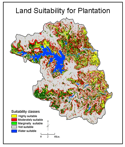
Multi-Criteria Land Suitability Analysis for Plantation in Upper Mula and Pravara Basin: Remote Sensing and GIS Approach
Rajendra Zolekar, Vijay Bhagat
Assessment of land suitability potentials is an important step to detect the environmental limit for sustainable land management (SLM). Land suitability analysis (LSA) is more suitable, beneficial and environmentally acceptable for SLM. It deals with the assessment of land performances for the specific use like agriculture, plantation, etc. The main objective of the present study was to determine the suitable areas f…
10.21523/gcj5.18020102 1,215 views 7 citations 31 Dec 2018
-
pp. 22-29 Open access
Predicting the Amount of Fertilizers using Linear Programming for Agricultural Products from Optimum Cropping Pattern
Mohammad Heydari, Faridah Othman, Meysam Salarijazi, Iman Ahmadianfar, Mohammad Sadegh Sadeghian
The most crucial problem in resolving the challenges of water operations is usually maintaining the equilibrium between supply and demand for water especially in arid and semi-arid regions like most parts of Iran. In this research, to achieve the optimal cropping pattern, firstly, the study area was classified into six classes and just 2100 hectares of farming area in the top class that had the best agricultural cond…
10.21523/gcj5.18020103 941 views 2 citations 31 Dec 2018
-
pp. 30-40 Open access
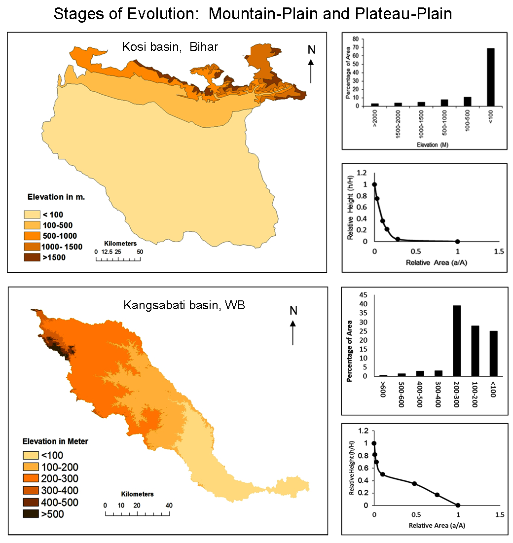
Determination of Evolution Stages of Landform - A Comparative Study of Mountain-Plain Kosi Bihar and Plateau-Plain Kangsabati WB Regions of Tropical India
The major aim of quantitative geomorphology is to understand the geomorphological stages of evolution of any area. The quantitative revolution and the development of remote sensing and GIS techniques have brought greater attention to this field of analysis. We have used a morphometric analysis, which is an important indicator to understand the geomorphic stages of evolution of any drainage basin, to compare the drain…
10.21523/gcj5.18020104 941 views 1 citation 22 Feb 2019
-
pp. 41-52 Open access
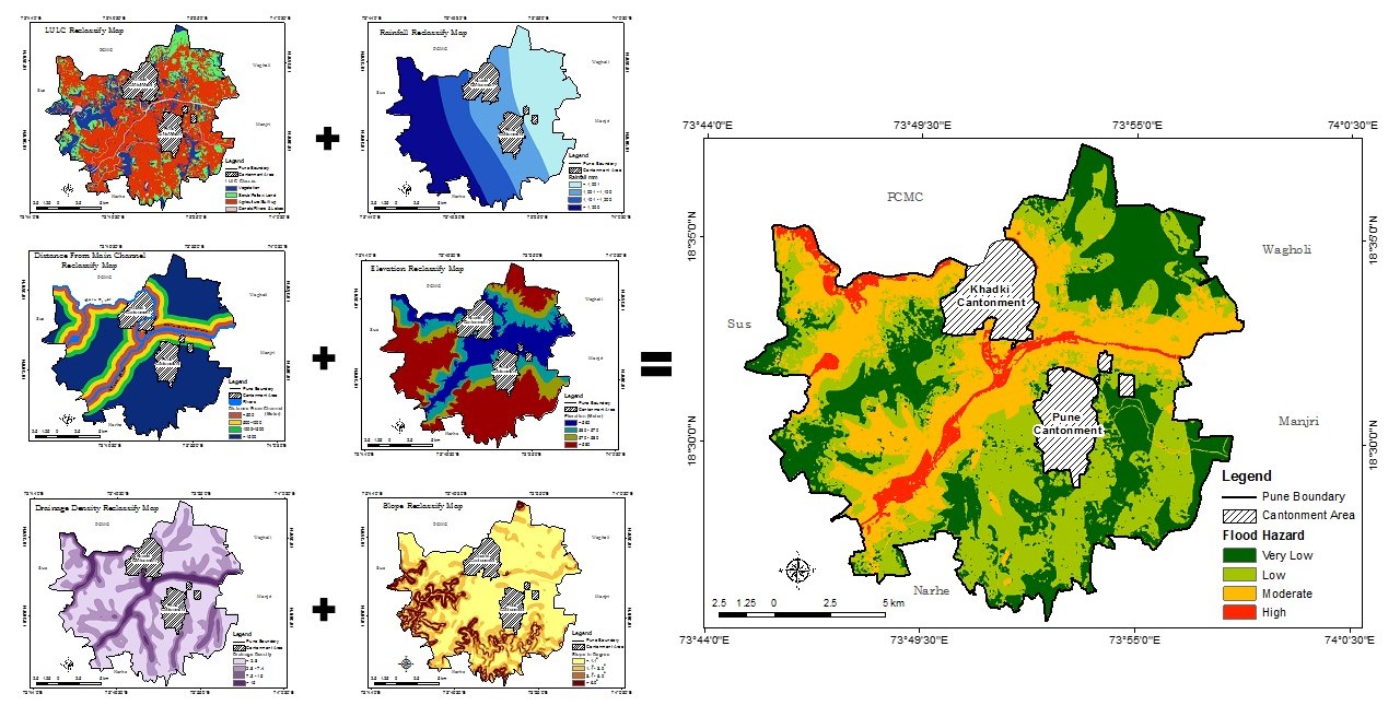
Multi-Criteria Decision Making for Vulnerability Mapping of Flood Hazard: A Case Study of Pune City
Floods are natural risk with a very high frequency, which causes to environmental, social, economic and human losses. The floods in the town happen mainly due to human made activities about the blockage of natural drainage, haphazard construction of roads, building, and high rainfall intensity. Detailed maps showing flood vulnerability areas are helpful in management of flood hazards. Therefore, present research focu…
10.21523/gcj5.18020105 3,677 views 13 citations 13 Mar 2019
Credits to reviewers (52)
- Dr. Vijay Bhagat, Post-graduate Research Centre in Geography, Agasti Arts, Commerce and Dadasaheb Rupwate Science College, Akole-422601, Ahmednagar, Maharashtra (India).
- Dr. Suyash Kumar, Geology Department, Govt. PG Science College, Gwalior, MP 474009 India.
- Dr. Nitin Mundhe, Post Graduate Teaching & Research Centre, Department of Geography, S. P. College, Pune
- Dr. Archana Patil, RNC Arts, JDB Commerce and NSC Science College, Nashik Road, India
- Dr. Ravindra Medhe, Department of Geography, Savitribai Phule Pune University, Pune
- Dr. Chaitanya Pande, All India coordinate research project for dry land agriculture, Dr. Panjabrao Deshmukh Krishi Vidyapeeth, Akola
- Dr. BHAVANA Umrikar, Department of Geology, Savitribai Phule Pune University, Pune - 411 007 (India).
- Dr. Sanjay Kale, Department of Environmental Sciences, University of Pune, Pune- 411 007.
- Dr. Driss Bouyahya, Moulay Ismail University, Meknès Morocco School of Arts and Humanities
- Dr. Sainath Aher, Post Graduate Department of Geography, S. N. Arts, D. J. Malpani Commerceand B.N. Sarda Science College, Sangamner 422 605, India
- Dr. Mohammad Suhail, AS College, Lakhaoti, BSR, CCS University, Meerut, Uttar Pradesh (India).
- Professor. Shahida Murtaza, Deartment of Women Education,Maulana Azad National Urdu University,Gacchibowli,Hyderabad. 5000032Telengana.India.
- Dr. Taruna Bansal, Department of Geography, Jamia Millia Islamia - A Central University, New Delhi-110025 (India).
- Prof. Lubna Siddiqui, Department of Geography, Jamia Millia Islamia, New Delhi-110025 (India).
- Dr. Saif Said, Department of Civil Engineering, Z. H. College of Engineering and Technology, Aligarh Muslim University (AMU), Aligarh U.P. (India).
- Professor. Shahab Fazal, Department of Geography, Aligarh Muslim University, Aligarh, UP
- Dr. Ananad Malik, Swami Sharadhanand College, Delhi University
- Dr. Firdous Azmat Siddiqui, Sarojini Naidu Centre for Women's Studies, Jamia Millia Islamia, New Delhi
- Mr. Gajendra Singh Yadav, AFC
- Professor. Mohd. Firoz Khan, Department of Geography, JMI, New Delhi
- Dr. Raihan Ahmed, Department of Geography, Jamia Millia Islamia, New Delhi
- Professor. Somnath Dasgupta, Chair Professor, Department of Geography, Jamia Millia Islamia, New Delhi
- Dr. Abhay Kumar, Lokashraya Foundation, A-101, Gauri Sadan, 5-Hailey Road, New Delhi-110001
- Dr. R Islam, Wadia Institute of Himalayan Geology
- Dr. Ajaykumar Kadam, Department of Geology, Savitribai Phule Pune University, Pune
- Professor. Nizamuddin Khan, Department of Geography, AMU Aligarh
- Professor. Abdul Muneer, AMU Aligarh
- Dr. Rajasekhar M, Department of Geology, Yogi Vemana University, Kadapa-516003, Andhra Pradesh (India).
- Dr. Rahul Todmal, VP's ASC College Baramati, Pune (Maharashtra)
- Dr. K. V. Suryabhagavan, School of Earth Sciences, Addis Ababa University, P.O. Box 1176, Addis Ababa, Ethiopia.
- Prof. Syed Ahmad Ali, Department of Geology, AMU Aligarh
- Dr. SHANKAR KARUPPANNAN, Department of Aplied Geology,School of Applied Natural Sciences (SoANS), Adama Science & Technology University, Adama, Ethiopia.
- Dr. Nanabhau Kudnar, C. J. Patel College Tirora, Gondia
- Mr. Sumit Das, Savitribai Phule Pune University, Pune
- Dr. Arun Magar, Department of Geography, Tuljaram Chaturchand College of Arts, Science and Commerce College, Vivekanand Nagar, Baramati- 413102,Maharashtra (India).
- Dr. Santosh Bhailume, Department of Geography, K.V.N. Naik College Nashik
- Prof. Biplab Biswas, Department of Geography, Bardawan University, West Bengal
- Miss. Abhra Singh, Jamia Millia Islamia, New Delhi
- Professor. Mamdouh El-Hattab, Institute of Environmental Studies and Research, University of Sadat City, Egypt.
- Dr. Yogesh Badhe, Department of Geography, Savitribai Phule Pune University, Pune - 411 007 (India).
- Dr. Sagar Mali, Department of Geography,Vidya Prabodhini College of Commerce, Education, Computer and Management, Vidyanagar, Alto-Parvari-Goa.
- Dr. Murugesan Bagyaraj, Department of Geology, College of Natural and Computational Sciences, Debre Berhan University, Debre Berhan, Ethiopia.
- Dr. Selvakumar P, Department of Chemical Engineering, ASTU, Adama, Ethiopia.
- Dr. Md. Baharuddin Shah, P. G. Department of Geography, G. P. Women's College, DHANAMANJURI UNIVERSITY, Imphal
- Dr. Shrinwantu Raha, Bhairab Ganguly College, Belgharia-7,000,56, West Bengal, India.
- Professor. Arjun Doke, Baburaoji Gholap College Sangavi Pune-27 Maharashtra India
- Dr. Sanjay Navale, Department of Geography, S. N. Arts, D.J.M. Commerce and B.N.S. Science College, Sangamner, Dist.Ahmednagar, Maharashtra (India), 422605.
- Professor. Rajendra Zolekar, Department of Geography, K.V. N.Naik College Nashik
- Dr. Shah Fahad, Department of Geography, Institute of Science, Banaras Hindu University, VARANASI
- Dr. Adnan Shakeel, Jamia Millia Islamia, New Delhi
- Professor. Poonam Sharma, Shaheed Bhagat Singh College, University of Delhi, Sheikh Sarai , Phase-II, New Delhi 110017, India
- Dr. MD. Kaikubad Ali, Department of Geography, Jamia Millia Islamia