Article Title :
Determination of Evolution Stages of Landform - A Comparative Study of Mountain-Plain Kosi Bihar and Plateau-Plain Kangsabati WB Regions of Tropical India 
2 (2018)
30-40
GIS , SRTM , Geomorphic Control , Hypsometric characteristics , Kangsabati , Kosi , Tropical India , Morphometric analysis , Geomorphological Stages , Quantitative geomorphology


The major aim of quantitative geomorphology is to understand the geomorphological stages of evolution of any area. The quantitative revolution and the development of remote sensing and GIS techniques have brought greater attention to this field of analysis. We have used a morphometric analysis, which is an important indicator to understand the geomorphic stages of evolution of any drainage basin, to compare the drainage basin characteristics and related stages of evolution of a mountain-plain and plateau-plain drainage basin in tropical India. The Kosi basin has been selected for the mountain-plain area and Kangsabati basin is the chosen region for the plateau-plain area. Different drainage morphometric parameters and measurements related to linear, areal, relief characteristics have been determined through the use of SRTM (Shuttle Radar Topographic Mission) GeoDEM and ARC GIS 10.1. Area-altitude relationship and hypsometric characteristics have also been accessed to identify the stages of geomorphic evolution. All the relief characteristics indicate Kosi in a young or rejuvenated stage when compared to the mature plateau region of the river of Kangsabati. Morphometric characteristics also indicate that there are high geologic and geomorphological controls on river basin characteristics.
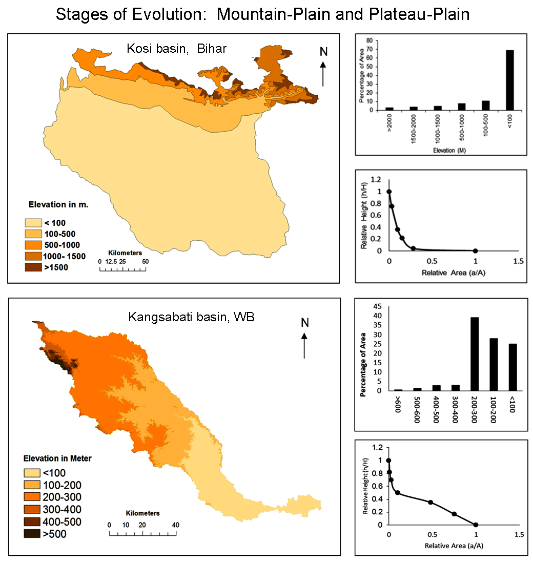
Morphometric analysis is useful to understand the geomorphic stages of evolution of the river basin.
Morphometric parameters: linear, areal and relief aspects are analysed using SRTM data and GIS.
Altitude and hypsometric characteristics have also been accessed to identify the stages of geomorphic evolution.
All the relief characteristics indicate Kosi in a young or rejuvenated stage compared to the mature plateau region of the river of Kangsabati.
Arogyaswamy, R. N. P., 1971. Some geological factors influencing the behaviour of the Kosi. Records of Geological Survey of India, 96, 42-52.
Chorley, R. J. Schumm, S. A. and Sugden, D. E., 1985. Geomorphology. London: Methuen and Co. Ltd.
Horton, R. E., 1932. Drainage Basin Characteristics (1’st ed.). New York: Trans. Amer. Geophys.
Lindsay, J. B. and Seibert, J., 2013. Measuring the significance of a divide to local drainage patterns. International Journal of Geographical Information Science, 27(7), 1453-1468.
Nag, S. K. and Lahiri, A., 2012. Hydro chemical characteristics of groundwater for domestic and irrigation purposes in Dwarakeswar Watershed Area, India. American Journal of Climate Change, 1, 217-230.
Sharma, S. and Sarma, J. N., 2013. Drainage analysis in a part of the brahmaputra valley in Sivasagar District, Assam, India, to detect the role of nontectonic activity. J. Indian Soc. Remote Sens., 41(4), 895-904.