Article Title :
Remote Sensing Based Assessment of Agricultural Droughts in Sub-Watersheds of Upper Bhima Basin India 

2 (2018)
105-111
Remote Sensing , Drought , MODIS , NDVI , Vegetation Condition Index , Temperature Condition Index


Drought assessment for agricultural sector is vital in order to deal with the water scarcity in Ahmednagar and Pune districts, particularly in sub-watersheds of upper catchment of the River Bhima. Moderate Resolution Imaging Spectro-radiometer (MODIS) satellite data (2000, 2002, 2009, 2014, 2015 and 2017) for the years receiving less rainfall have been procured and various indices were computed to understand the intensity of agricultural droughts in the area. Vegetation health index (VHI) is computed on the basis of vegetation moisture, vegetation condition and land surface temperature condition. Most of the reviewed area shows moderate to extreme drought conditions.
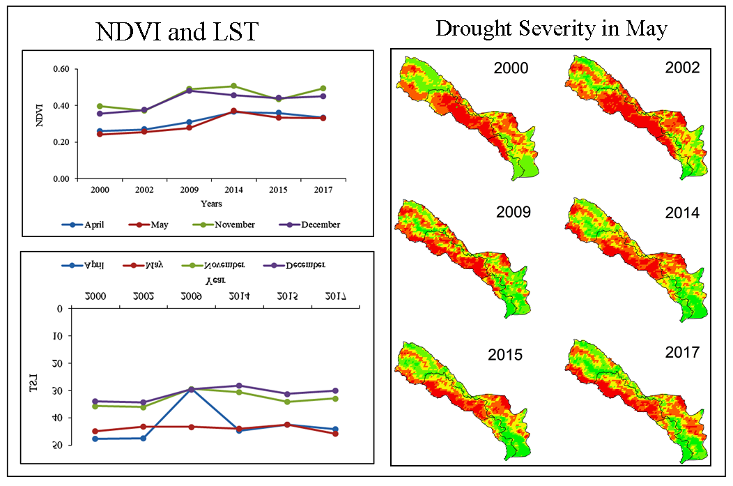
Assessment was performed to understand the drought severity in semi-arid region.
MODIS satellite data was used for drought assuagements with Vegetation Health Index (VHI) for predicting agricultural drought intensity.
Vegetation health index (VHI) was computed on the basis of vegetation moisture, vegetation condition and land surface temperature condition.
Most of the reviewed area was classified as extreme to moderate drought conditions.
Arshad, S., Morid, S., Mobasheri, M. R., and Alikhani, M. A., 2007. Development of agricultural drought risk assessment model for Kermanshah Province (Iran), using satellite data and intelligent methods. In Proceeding: The first international conference on Drought Management, Zaragoza, Spain, 12, 303-310.
Dutta, D., Kundu, A., Patel, N. R., Saha, S. K., and Siddiqui, A. R., 2015. Assessment of agricultural drought in Rajasthan (India) using remote sensing derived Vegetation Condition Index (VCI) and Standardized Precipitation Index (SPI). The Egyptian Journal of Remote Sensing and Space Science, 18(1), 53-63.
Garg, K. K., Gaur, A., and Immerzeel, W. W., 2008. Integrating spatial dynamics for sustainable water management at the river basin scale: identify areas to improve agricultural water productivity in upper Bhima Catchment of South India, IWMI Conference Proceedings 273365, International Water Management Institute.
Khalil, A. A., Abdel-Wahab, M. M., Hassanein, M. K., Ouldbdey, B., Katlan, B., and Essa, Y. H., 2013. Drought monitoring over Egypt by using MODIS land surface temperature and normalized difference vegetation index. Nature and Science, 11(11), 116-122.