
Journal Open access Double-blind peer review
Remote Sensing of Land
'Remote Sensing of Land' (RSL) publishes double-blind peer-reviewed articles within all fields of remote sensing of the land.
Editor-in-Chief Dr. Suresh Kumar (Agriculture, Forestry & Ecology Group, Indian Institute of Remote Sensing, Dehra Dun -248001, Uttarakhand, India.)
Managing Editor Dr. Kalpana Bhagat  (Gatha Cognition.)
- Articles published
- 38
- Crossref citations
- 292
- Citation ratio · Crossref
- 7.68
- Citation ratio · OpenAlex
- 9.55
Citation ratio = citations ÷ all articles published since the first issue.
Issue
Volume 2 (2018) · Issue 2
Original Research Paper
-
pp. 76-86 Open access
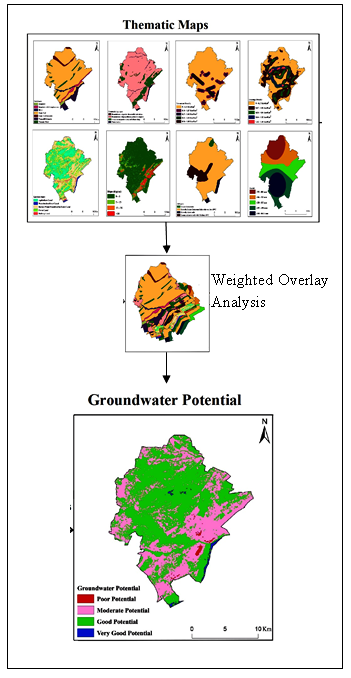
Delineation of Groundwater Potential Zones of Semi-Arid Region of YSR Kadapa District Andhra Pradesh India using RS GIS and Analytic Hierarchy Process
Rajasekhar M, Sudarsana Raju G, Bramaiah C, Deepthi P., Amaravathi Y, Siddi Raju R
Water scarcity due to increasing urbanization and population in urban and rural areas makes necessary planning for artificial groundwater recharge. Remote Sensing (RS), Geographic Information System (GIS) and Analytical Hierarchy Process (AHP) are advantageous tools to delineate the Groundwater Potential Zones (GWPZ) in arid and semi-arid areas of India. An aggregate of eight thematic layers affecting groundwater pot…
10.21523/gcj1.18020201 1,296 views 17 citations 20 Mar 2019
Technical Paper
-
pp. 87-95 Open access
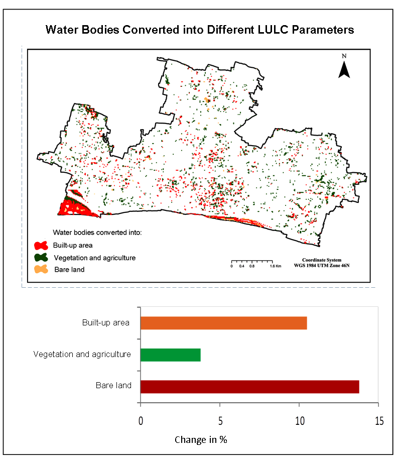
Identifying Most Influential Land Use Parameters Contributing Reduction of Surface Water Bodies in Rajshahi City Bangladesh: A Remote Sensing Approach
Abdulla - Al Kafy, Muhaiminul Islam, ABDUR ROUF KHAN, Lamia Ferdous, MD. MAMUN HOSSAIN
Surface water bodies are one of the irreplaceable natural resources for human survival, and it extensively reduces with increasing the world population. This study modeled the spatiotemporal changes of land use / land cover (LULC) and identified the most influential LULC parameters, which contributes in the reduction of surface water bodies using the Landsat 4 and 5 TM and Landsat 8 OLI images (1992-2017). Rajshahi C…
10.21523/gcj1.18020202 1,100 views 21 citations 14 Apr 2019
-
pp. 105-111 Open access
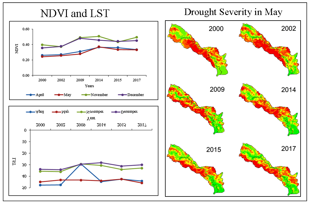
Remote Sensing Based Assessment of Agricultural Droughts in Sub-Watersheds of Upper Bhima Basin India
Nayan Zagade, Ajaykumar Kadam, BHAVANA Umrikar, Bhagyashri Maggirwar
Drought assessment for agricultural sector is vital in order to deal with the water scarcity in Ahmednagar and Pune districts, particularly in sub-watersheds of upper catchment of the River Bhima. Moderate Resolution Imaging Spectro-radiometer (MODIS) satellite data (2000, 2002, 2009, 2014, 2015 and 2017) for the years receiving less rainfall have been procured and various indices were computed to understand the inte…
10.21523/gcj1.18020204 987 views 6 citations 12 Aug 2019
Review Article
-
pp. 96-104 Open access
Remote Sensing Satellites for Land Applications: A Review
Satellite remote sensing offers a unique opportunity in deriving various components of land information by integrating with ground based observation. Currently several remote sensing satellites are providing multispectral, hyperspectral and microwave data to cater the need of various land applications. Several old age remote sensing satellites have been updated with new generation satellites offering high spatial, sp…
10.21523/gcj1.18020203 14,675 views 3 citations 4 Jul 2019
Credits to reviewers (32)
- Dr. Vijay Bhagat, Post-graduate Research Centre in Geography, Agasti Arts, Commerce and Dadasaheb Rupwate Science College, Akole-422601, Ahmednagar, Maharashtra (India).
- Dr. Lachezar Filchev, Department of Remote Sensing and GIS, Space Research and Technology Institute at the Bulgarian Academy of Sciences (SRTI-BAS).
- Dr. Tarik Mitran, National Remote Sensing Centre, ISRO,Hyderabad – 500037 (India)
- Dr. Vanya Stamenova, Space Research and Technology Insitute - Bulgarian Academy of Sciences
- Dr. Chaitanya Pande, All India coordinate research project for dry land agriculture, Dr. Panjabrao Deshmukh Krishi Vidyapeeth, Akola
- Dr. Kishor R. Sonawane, Post-graduate Research Centre in Geography, Agasti Arts, Commerce and Dadasaheb Rupwate Science College, Akole-422601, Ahmednagar, Maharashtra (India).
- Professor. Ayad Al-Quraishi, Environmental Engineering Dept., College of Engineering, Knowledge University, Erbil 44001
- Dr. Sainath Aher, Post Graduate Department of Geography, S. N. Arts, D. J. Malpani Commerceand B.N. Sarda Science College, Sangamner 422 605, India
- Mr. Milad Janalipour, Department of Photogrammtery & Remote SensingFaculty of Geodesy and Geomatics EngineeringK. N. Toosi University of Technology
- Professor. Ali Mohammadzadeh, Remote Sensing Dept., Faculty of Geomatics Engineering, K.N.Toosi University of Technology, Tehrān, Iran.
- Dr. S. Sarvade, Assistant Professor, Department of Forestry, JNKVV Jabalpur
- Dr. SN Patil, Department of Geology, School of Environmental and Earth Sciences, North Maharashtra University, Jalgaon-425001, Maharashtra (India)
- Dr. Shridhar Jawak, University Centre in Svalbard (UNIS), SIOS - Svalbard Integrated Arctic Earth Observing System, SIOS Knowledge Centre, P.O. Box 156, N-9171 Longyearbyen, Norway.
- Dr. Ajaykumar Kadam, Department of Geology, Savitribai Phule Pune University, Pune
- Mr. Kajal Kumar Mandal, Department of Disaster Management, Pondicherry University, Port Blair Campus, Andaman, India.
- Dr. Rajasekhar M, Department of Geology, Yogi Vemana University, Kadapa-516003, Andhra Pradesh (India).
- Dr. Hamdi Zurqani, University of Tripoli, Department Soil and Water Sciences
- Dr. K. V. Suryabhagavan, School of Earth Sciences, Addis Ababa University, P.O. Box 1176, Addis Ababa, Ethiopia.
- Dr. S.P Rao, University of Dodoma
- Mr. Abhishek Danodia, Indian Institute of Remote Sensing
- Mrs. Minakshi Kumar, Indian Institute of Remote Sensing
- Dr. Satyajit Gaikwad, Department of Geology, Savitribai Phule Pune University, Pune
- Dr. SHANKAR KARUPPANNAN, Department of Aplied Geology,School of Applied Natural Sciences (SoANS), Adama Science & Technology University, Adama, Ethiopia.
- Mr. Justin George K, Indian Institute of Remote Sensing
- Dr. Muhammad Sohail Memon, Department of Farm Power and Machinery, Faculty of Agricultural Engineering, Sindh Agriculture University, Tandojam, Pakistan
- Dr. Murugesan Bagyaraj, Department of Geology, College of Natural and Computational Sciences, Debre Berhan University, Debre Berhan, Ethiopia.
- Dr. Shrinwantu Raha, Bhairab Ganguly College, Belgharia-7,000,56, West Bengal, India.
- Dr. M. V Rao, Andhra University
- Dr. Pankaj Panwar, CSWCRTI, Chandigarh
- Dr. Sanjay Navale, Department of Geography, S. N. Arts, D.J.M. Commerce and B.N.S. Science College, Sangamner, Dist.Ahmednagar, Maharashtra (India), 422605.
- Mr. Justin George Kalambukattu, Agriculture and Soils Department,Indian Institute of Remote Sensing, ISRO, Dehradun 248001, Uttarakhand, India
- Professor. Rajendra Zolekar, Department of Geography, K.V. N.Naik College Nashik