

Article Title :
Optical and Radar Data Analysis for Land Use Land Cover Mapping in Peru 
3 (2019)
15-27
divergence , land use land cover , radar , optical , Remote Sensing


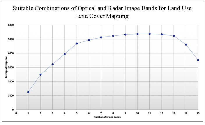
This analysis determined the best individual band and combinations of various numbers of bands for land use land cover mapping for three sites in Peru. The data included Landsat Thematic Mapper (TM) optical data, PALSAR L-band dual-polarized radar, and derived radar texture images. Spectral signatures were first obtained for each site class and separability between classes determined using divergence measures. Results show that the best single band for analysis was a TM band, which was different for each site. For two of the three sites, the second best band was a radar texture image from a large window size. For all sites the best three bands included two TM bands and a radar texture image. The original PALSAR bands were of limited value. Finally upon further analysis it was determined that no more than six bands were needed for viable classification at each study site.
The best single band for analysis was a Landsat Thematic Mapper band, which was different for each study site.
The best combination of bands included bands from different remote sensing sensors that represent different wavelengths and physical properties of the landscape.
No more than six bands were needed for a viable classification at each study site.
Divergence analysis presents a useful approach that can be used to prioritize the collection of remote sensing imagery prior to land use and land cover mapping.
Chandra, A. M. and Ghosh, S. K., 2006. Remote sensing and Geographical Information System. Alpha Science International Limited, Oxford, UK., 79-97.
Haack, B. and Mahabir, R., 2017. Separability analysis of integrated spaceborne radar and optical data: Sudan case study. Journal of Remote Sensing Technology, 5, 10-21.
Sinduja, R., Chidambaram, S. and Sumathi, A., 2015. Analysis of dimensionality reduction techniques for hyperspectral image classification. International Journal of Engineering Trends and Technology, 21(2), 111-115.
World Fact Book 2019. South America. Peru. Accessed on 2 July 2019.
