Article Title :
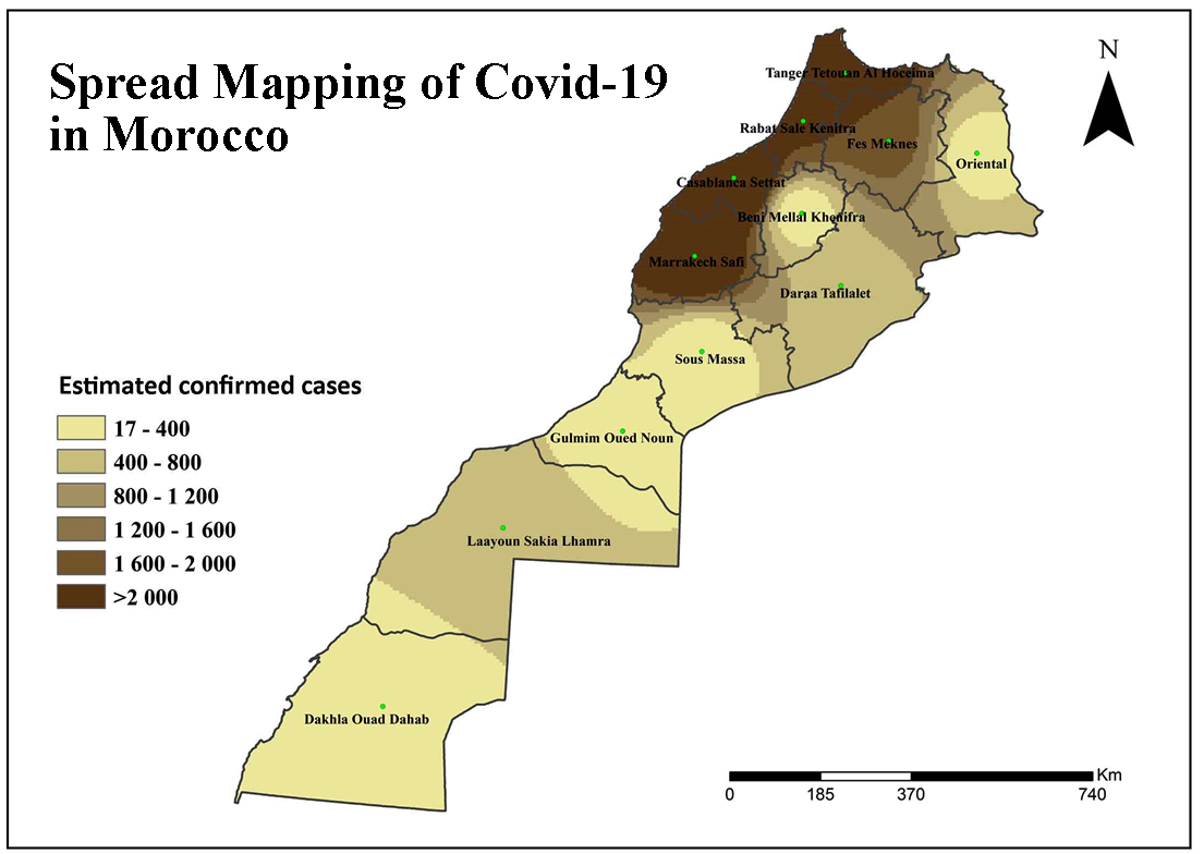
Spread Mapping of Covid-19 in Morocco Using Geospatial Approach 
Elhoucein LAYATI
 ,
Abdellah Ouigmane
,
Marcelo de Carvalho Alves
,
Murugesan Bagyaraj
,
Mohamed ELGHACHI
,
Abdellah Ouigmane
,
Marcelo de Carvalho Alves
,
Murugesan Bagyaraj
,
Mohamed ELGHACHI
4 (2020)
35-43
COVID-19 , GIS , Inverse Distance Weighted (IDW) , Morocco , Spatial Distribution


Most of the people infected in Morocco are triggered by the outbreak of COVID-19. The number of affected cases is currently rising day by day. As of July 16th, 2020, In Morocco, 15,165 cases were tested positive for COVID-19, including 239 deaths and 11,417 patients cured the highest number of Corona virus cases reported as Ministry of Health Department in Morocco. The COVID-19 virus threatens the health, economy, development and social life of individuals. The city needs to be conscious of the fight against this epidemic. GIS technology has played an important role in many aspects, including geospatial perception, geostatistical simulation and spatial knowledge enabling decision-making, mitigation and prediction including COVID-19. GIS has evolved reasonably rapidly and has a full technical route for data processing, modeling and map creation. However, in the battle against the popular endemic, the key challenge is to find ways of controlling conventional technological methods and to increase the quality and accuracy of the knowledge provided for social management. As a consequence, IDW and computational approaches are used to forecast potential cases in the region. Prediction of different parameters existing confirmed events, death and recovery of COVID-19. See reports have been used to take proactive measures in order to penetrate regions. The suggested method of understanding is effective within a certain context and would be a valuable tool for both governments and health authorities.
The human life is threatened by Covid-19 worldwide.
GIS tools are playing vital role in mapping of Covid-19.
IDW [inverse distance weighted] method is used for Spread Mapping of Covid-19 in Morocco.
The suggested method is effective and valuable tool for Covid-19 mapping.
Brooker, S., Kabatereine, N. B., Smith, J. L., Mupfasoni, D., Mwanje, M.T, Ndayishimiye, O., Lwambo, N. JS., Mbotha, D., Karanja, P., Mwandawiro, C., Muchiri. E., Clements, A. CA., Bundy, D. AP. And Snow, R.W., 2009. An updated atlas of human helminth infections: The example of EastAfrica. International Journal of HealthGeographics. 8, 1-11.
Burrough, P.A. and McDonnell, R.A., 1998. Principles of Geographic Information Systems, 1998. Oxford ; New York : Oxford University Press.
CAICT [China Academy of Information and Communications Technology], 2020. Research Report on Data and Intelligent Application in Epidemic Prevention and Control (1.0). Accessed 29 June 2020.
Cheng, Y. J., Norris, J., Bao, C. J., Liang, Q., Hu, J.L., Wu, Y., Tang, F.Y., Liu, W.D., Ding, K. Q., Zhao, Y., Peng, Z. H., Yu, R. B., Wang, H., Shen. H. B. and Chen, F., 2012. Geographical information system-based spatial analysis and implications for syphilis interventions in Jiangsu province, People’s Republic of China. Geospatial Health 7 (1), 63-72.
Childs, C., 2004. Interpolating surfaces in ArcGIS spatial analyst. ArcUser, July-September, 3235, 569.
Johnston, K., Hoef, V. J. M., Krivoruchko, K. and Lucas, N., 2004. Using ArcGIS geostatistical analyst environmental systems research, Redlands, U.S.A., 114.
Katharina, H., Marius, A. and Edzer. P., 2011. Spatial interpolation in massively parallel computing environments. AGILE, April 18-22.
Krige, D.G., 1966. Two dimensional weighted moving average trend surfaces for ore-evaluation. Journal of the South African Institution of Mining and Metallurgy, 66: 13-38.
Laborde, J. P., 2000. Méthodes d’interpolation et géostatistiques pour la cartographie automatique. Université de Nice, Sophia Antipolis, CNRS-UMR, 5651, 27.
Maged, N., Boulos, K. and Estella, M. G., 2020. Geographical tracking and mapping of coronavirus disease COVID-19/severe acute respiratory syndrome coronavirus 2 (SARS-CoV-2) epidemic and associated events around the world: How 21st century GIS technologies are supporting the global fght against outbreaks and epidemics, International Journal of Health Geographics.
Qayssar, M. A., Muntadher, A. S., Nihad, D. H., Sumaya, F. H. and Noori, A.M., 2018. GIS based spatial modeling to mapping and estimation relative risk of different diseases using inverse distance weighting (IDW) Interpolation Algorithm and Evidential Belief Function. International Journal of Engineering & Technology, 7(4.37); 185-191.
Quenum, M., 2009. Cartographie à l’échelle de la parcelle agricole de variables indicatrices de la capacité des sols à fixer le phosphore à l’aide de la télédétection et des nouvelles technologies. Université du Québec, INRS-ETE, Thèse dotorale, 16-20.
Robinson, T. P. and Metternicht, G., 2003. Optimal spatial interpolation of soil properties to assist precision agriculture. Conf. Spatial Sciences. ACT.