

Article Title :
Modeling Soil Erosion Vulnerability Using RUSLE: A Case Study Upstream of Nangal Reservoir, India 
4 (2020)
1-11
Watershed management , RUSLE , Remote Sensing , GIS , Soil


Simulation of soil erosion is an important phenomenon in watershed management studies because of the dynamic nature of soil. The present study demonstrates the capabilities of remote sensing coupled with GIS to extract soil erosion vulnerabilities using RUSLE model. Therefore this study understands spatial distribution of soil erosion at a macro-watershed scale. The input parameters for RUSLE model include the rainfall and erosivity (R) derived using the TRMM satellite precipitation product for a long term implementing regression model. The soil erodibility (K) factor is estimated using available soil map, and the topographic factor (LS) from 12m ALOS PALSAR DEM. The management practice information was extracted from the land use / cover map based on 30m multi spectral LANDSAT-8 of three season datasets. The RUSLE model predicted very low, low, moderate, high and very high erosion in 84.8%, 7.9%, 4.4%, 2.3% and 0.7% of reviewed area, respectively. The results were validated with ground infromation and NDVI, being the main identifiers of soil erosion. As presence of high vegetation indicates higher strength to hold the soil particles together and prevent soil erosion, correlation coefficient was generated to find accuracy of the results with NDVI of the area. The strong positive correlation (0.5) provided scientific support that prediction of soil erosion by RUSLE can be effectively used for watershed management and combating action plan for soil erosion.
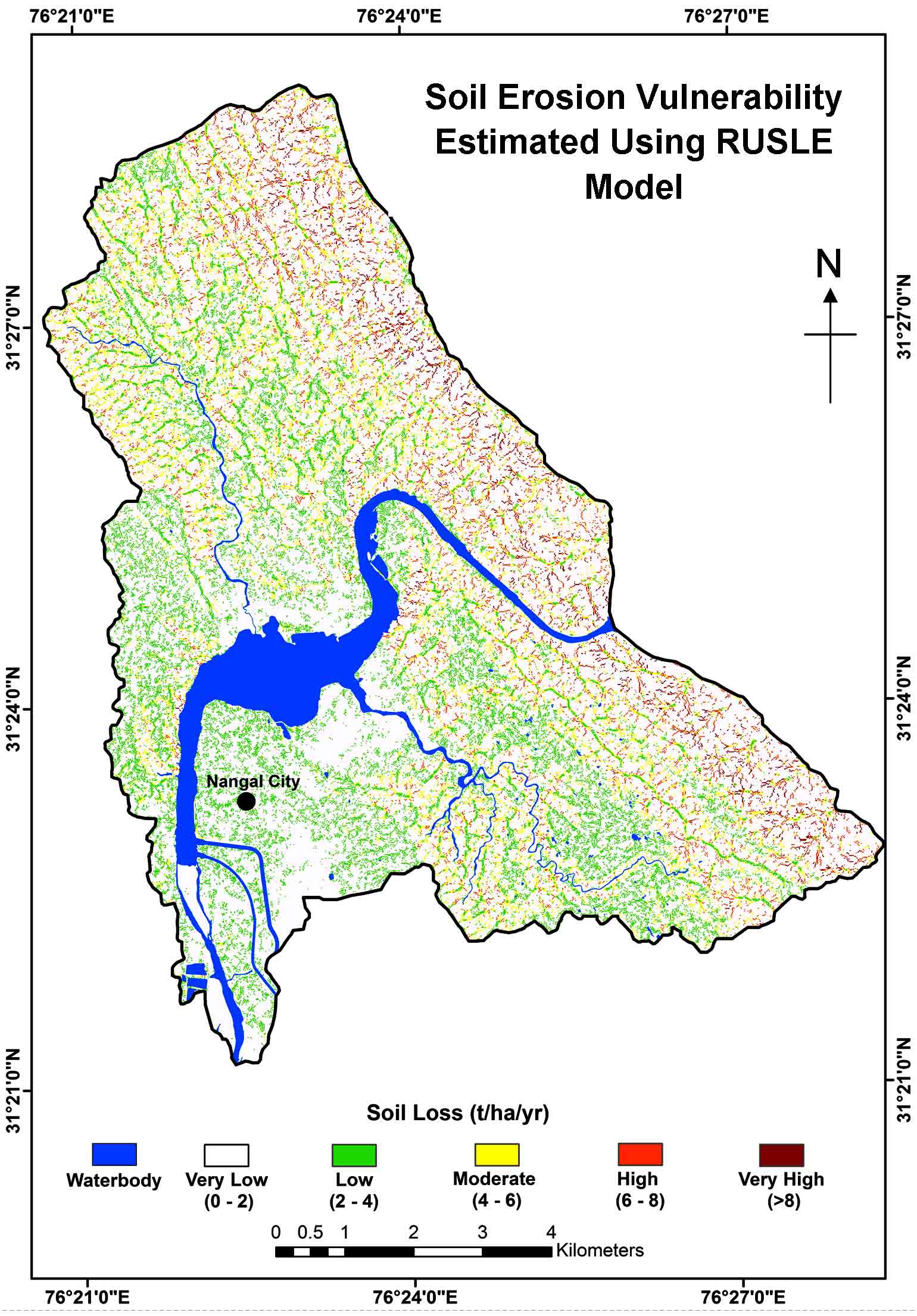
RUSLE model was used to identify the vulnerable zones of soil erosion.
Landsat-8, TRMM and ALOS PALSAR datasets were used for the analysis.
The model predicts very low, low, moderate, high and very high erosion in 84.8%, 7.9%, 4.4%, 2.3% and 0.7% of reviewed area, respectively.
The results were validated with ground information and NDVI image.
The strong positive relation was estimated between predicted soil erosion using RUSLE and ground truth information.
Blanco-Canqui, H. and Lal, R., 2008. Principles of soil conservation and management. Springer Science and Business Media.
Elwell, H.A., 1977. Soil loss estimation for southern Africa (p. 22) Harare: Zimbabwe Department of Conservation and Extension, Research Bulletin.
Foster, G. R., Yoder, D. C., Weesies, G. A., McCool, D. K., McGregor, K. C. and Bingner, R. L., 2003. RUSLE 2.0 user’s guide. USDA-Agricultural Research Service, Washington, DC.
Morgan, R. P. C., Quinton, J. N., Smith, R. E., Govers, G., Poesen, J. W. A., Auerswald, K., Torri, C. D. and Styczen, M. E., 1998. The European Soil Erosion Model (EUROSEM): A dynamic approach for predicting sediment transport from fields and small catchments. Earth Surface Processes and Landforms: The Journal of the British Geomorphological Group, 23(6), 527-544.
Renard, K. G. and Foster, G. R., 1983. Soil conservation: Principles of erosion by water. Dryland Agriculture, 23, 155-176.
Wener, C. G. 1972. Soil Conservation in Kenya, Nairobi. Ministry of Agriculture, Soil Conservation Extension Unit (1981).
Wischmeier, W. H. and Smith, D. D., 1978. Predicting rainfall erosion losses: A guide to conservation planning (No. 537). Department of Agriculture, Science and Education Administration.
