

Article Title :
Spatiotemporal Change Assessment of Lake Beseka, Ethiopia Using Time Series Landsat Images 

6 (2022)
27-39
Water index , Surface area , Landsat , Lake Beseka , Change Detection


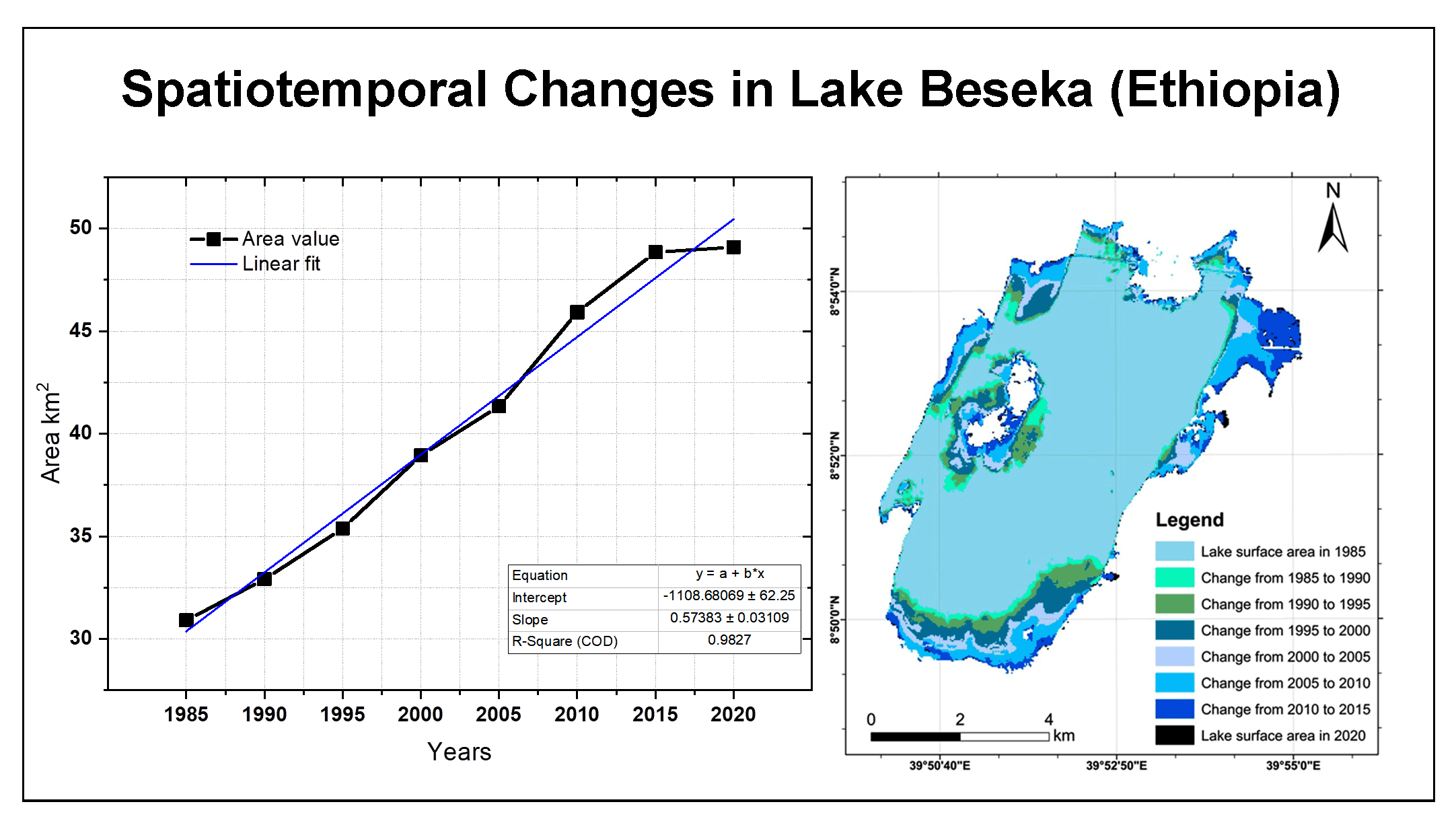
Changes in lake surface area and fluctuations in water levels are common especially in the Ethiopian Rift Valley region. The aim of this study was to present the spatiotemporal changes of lake Beseka from 1985 to 2020 using multi-temporal Landsat images. Four spectral water indices, namely Normalized Differential Water Index (NDWI), Modified Normalized Difference Water Index (MNDWI) and Automated Water Extraction Index (AWEI) were used for the extraction of the lake water. The results of the study show that lake Beseka has tended to expand significantly and strongly over the past 35 years. During 1985, the lake surface area was around 30.9km2 and within the next 35 years, the lake surface area increased by 18.18 km2and in 2020, its surface area is about 49.1 km2. lake Beseka shows 0.2412km2 area change from 2015 to 2020. This indicates lake Beseka has a decreasing trend of expansion compared to its history. However, the topography of Lake Beseka is lower in elevation a small water level rise in the lake can cover a large area and lead to significant impacts on the surrounding environment. Therefore, the monitoring of lake surface changes by multi-temporal satellite images is very necessary and of decisive importance.
Temporal satellite imageries are very crucial for change detection of lake surface area.
Integrating different water indexes enhance the accuracy of water body extraction.
Lake Beseka exhibits a remarkable and drastic expansion during the history.
Thresholding methods of separation of water from non-water feature is an easy computation.
Hailu, B. T. and Girma, S., 2019. Spatiotemporal lake level change of Lake Abijata, Ethiopia: A remote sensing approach. Environmental Analysis and Ecology Studies, 6(1).
Irons, J., Taylor, M. and Rocchio, L., 2013. Landsat Science. NASA.
Li, J. G., Huang, S. F. and Li, J. R., 2010. Research on extraction of water body from ENVISAT ASAR images: A modified Otsu threshold method. Journal of Natural Disasters, 19(3):139-145.
Olaka, L. A., Odada, E. O., Trauth, M. H. and Olago, D. O., 2010. The sensitivity of East African rift lakes to climate fluctuations. Journal of Paleolimnology, 44, 629-644.
Senbete, G., 2008. Participatory evaluation of Gillnet and long line on Lake Beseka, Ethiopia. Proceeding of Ethiopian Society of Animal Production, Addis Ababa, Ethiopia.
Sisay, A., 2016. Remote sensing based water surface extraction and change detection in the Central Rift valley region of Ethiopia. American Journal of Geographic Information System, 5(2), 33-39.
Tulbure, M. G., Broich, M. and Stehman, S. V., 2016. Spatiotemporal dynamics of surface water extent from three decades of seasonally continuous Landsat time series at subcontinental scale. International Archives of the Photogrammetry, Remote Sensing and Spatial Information Sciences- ISPRS Archives.

