Article Title :
Examining Urban Growth Dynamics and Sprawl Patterns of Ludhiana City, Punjab: A Geospatial Study 

10 (2026)
43-56
LULC , Ludhiana , Shannon’s entropy , Urbanization , Urban Sprawl




Accelerated urbanization has led to an increasing demand for land to build new areas of settlement and related infrastructure. This growing demand for land shows an encroachment onto related land uses and other natural areas. Therefore, it is important to critically examine the changing land-use/land-cover (LULC) patterns, particularly in highly urbanizing areas. This study is based on the Local Planning Area of Ludhiana, one of the most urbanized and industrialized cities in the state of Punjab, India. This study is aimed at evaluating changes in LULC over a period of forty-five years using remote sensing and GIS tools. A total of five LULC classes were used for the study: agriculture, built-up areas, forests, barren land and water bodies; and changes in area have been calculated for the years 1979, 1994, 2009 and 2024. The study utilizes the Landsat images, and classification was performed using the maximum likelihood technique with supervised classification using ArcGIS Pro. The study reveals that the area under agriculture was 72.22% in 1979, which dropped to 54.66% in 2024, whereas the area under built-up was 6.86%, which drastically increased to 30.76% by 2024. The other land use classes also witnessed a significant change, but the major transition was from agriculture to built-up, which is 39.08% of the total transition. To assess the urban sprawl, Shannon's entropy has been used. The results of Shannon's entropy revealed that the study area has a high level of urban sprawl, having relative entropy of 0.9773, 0.9729, 0.9691 and 0.9732 for years 1979, 1994, 2009 and 2024, respectively. The study offers insights into the nature of urban growth and sprawl in the Local planning Area of Ludhiana.
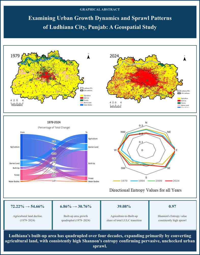
The study assessed four decades of LULC change in Ludhiana using remote sensing and GIS tools.
Agricultural land declined sharply from 72.22% in 1979 to 54.66% in 2024.
Built-up area quadrupled from 6.86% in 1979 to 30.76% by 2024 due to urban expansion.
Agriculture-to-built-up conversion accounted for 39.08% of total LULC transition.
Shannon's entropy value (0.97) reveals consistently high urban sprawl across 1979-2024.
Buttar, P. K. and Sachan, M. K., 2024. Generating Land Cover Maps in Semi-arid Regions Based on a 3D Semantic Segmentation Architecture Using Multi-temporal Sentinel-2 Satellite Images: A Case Study of Ludhiana District in Punjab, India. Journal of the Indian Society of Remote Sensing, 52(2), 383-398.
Pande, C. B., Srivastava, A., Moharir, K. N., Radwan, N., Mohd Sidek, L., Alshehri, F., Pal, S. C., Tolche, A. D. and Zhran, M., 2024. Characterising land use/land cover change dynamics by an enhanced random forest machine learning model: A Google Earth Engine implementation. Environmental Sciences Europe, 36(1), 84.