Article Title :
A Geomorphological Study on Centerline Migration of River Torsa in Sub-Himalayan Plains: Understanding River Dynamics 

10 (2026)
34-42
River Torsa , Remote Sensing , GIS , Landsat , Erosion and Accretion , Sinuosity Index




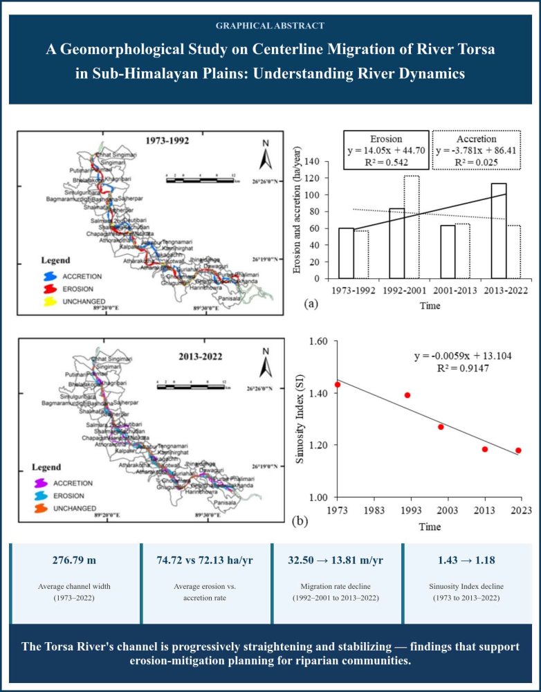
River channel centerline migration indicates the lateral movement of a river's central path across its floodplain over time in an alluvial river system situated in tectonically active areas, such as the Sub-Himalayan foothill region, resulting in many socioeconomic and environmental problems. This study analyses Channel Centerline Migration (CCM) resulting from bank erosion and accretion along the River Torsa in the Koch Bihar Sadar subdivision between 1973 and 2022 using RS and GIS. We examined four distinct periods (1973-1992, 1992-2001, 2001-2013, 2013-2022) to assess channel centerline migration patterns, rate of bank erosion and accretion, morphological characteristics (sinuosity index), and rates of width variations using Landsat MS, TM, and OLI-TRIS data. Results indicate gradual increase in channel width, channel stability and reduce channel meandering along stretch over time. The average erosion and accretion rates were found 74.72 ha/year and 72.13 ha/year along both banks. These results are significant for the prediction of channel migration rates in the context of engineering, planning, and soil-water management.
RS-GIS–based analysis of River Torsa's centerline migration in Koch Bihar Sadar subdivision, 1973–2022.
Channel width increased gradually over the 49-year period, averaging 276.79 m.
Average erosion and accretion rates were 74.72 ha/year and 72.13 ha/year, respectively.
Yearly migration rate declined from 32.50 m/year (1992–2001) to 13.81 m/year (2013–2022), indicating growing stability.
Sinuosity index fell from 1.43 (1973) to 1.18 (2013–2022), showing the channel is progressively straightening.
Findings support erosion-mitigation planning for riparian communities along the Torsa River.