Article Title :
Geospatial Assessment of Spatiotemporal LULC Dynamics in the Mula and Pravara River Basins 

10 (2026)
1-22
GIS , Remote Sensing , Landsat , Land use and land cover , Mula-Pravara River Basin




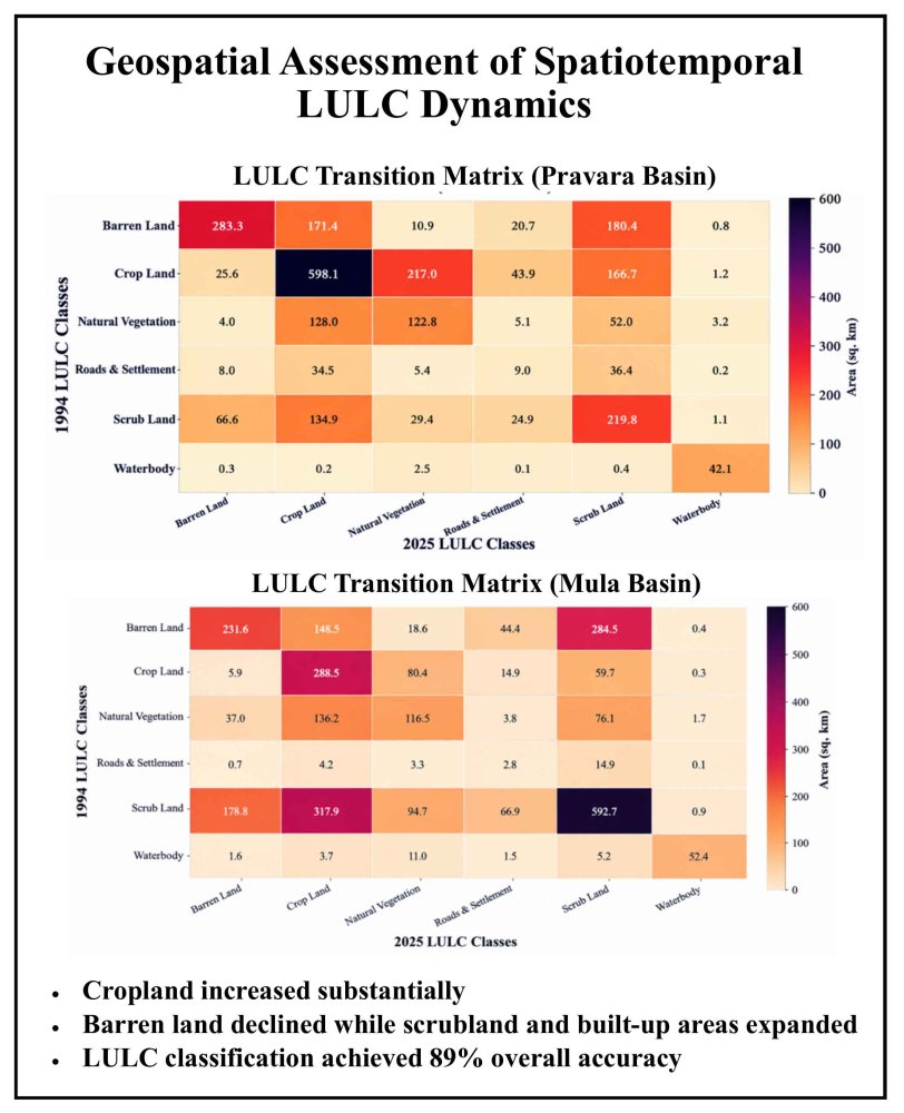
Land Use and Land Cover (LULC) dynamics provide essential insights into landscape transformation and its implications for environmental sustainability, agricultural development, and watershed management. The present study investigates temporal changes in LULC within the Mula and Pravara River Basins (MPRBs), located in the eastern region of the Western Ghats in Ahilyanagar District, Maharashtra, India. Together, the two basins cover approximately 5,551.3 km² and form part of the larger Godavari River basin. LULC changes during 1994–2025 were assessed using multi-temporal Landsat imagery, including Landsat-5 Thematic Mapper (TM) for 1994 and Landsat-9 Operational Land Imager-2 (OLI-2) and Thermal Infrared Sensor-2 (TIRS-2) for 2025. The classified imagery was grouped into six major classes: barren land, cropland, natural vegetation, roads and settlements, scrubland, and water bodies. The results revealed distinct LULC trajectories between the two basins. In the Pravara River Basin, cropland increased from 36.3% to 40.3%, while barren land decreased from 25.3% to 14.6% and scrubland increased from 18.1% to 24.7%. In the Mula River Basin, cropland increased substantially from 15.5% to 31.0%, whereas barren land declined from 25.1% to 15.7% and roads and settlements increased from 0.9% to 4.6%. Transition-matrix analysis using the ArcMap Combine tool quantified the direction and magnitude of class-to-class conversions and identified substantial transitions involving barren, scrub, cropland, and developed land. The 2025 classification achieved an overall accuracy of 89%, with a Kappa coefficient of 0.8959. The findings demonstrate spatially heterogeneous LULC transformation, with more pronounced agricultural and developed-land expansion in the Mula Basin. The study provides a quantitative baseline for future LULC monitoring and supports integrated land, water, and watershed management in the Deccan Trap region of Western Maharashtra.
LULC changes in the Mula and Pravara River Basins were assessed for 1994–2025.
Cropland increased substantially in both basins, particularly in the Mula River Basin.
Barren land declined while scrubland and built-up areas expanded during 1994–2025.
Transition-matrix analysis quantified major class-to-class LULC conversions.
The 2025 LULC classification achieved 89% overall accuracy and a Kappa coefficient of 0.8959.
Bhat, T. B., Wani, A. A., Mushtaq, S. M., Gatoo, A. A., Islam, M. A., Sofi, K. A., and Nisa, M. M. U., 2026. Assessment of Land Use–Land Cover and Phytosociological Characteristics of Bangus Grassland in the Ramhal Forest Range, Kashmir Himalaya. International Journal of Environment and Climate Change, 16(4), 486-497. .
Das, A., 2026. Prediction of Urban Surface Water Quality Scenarios Using Water Quality Index (WQI), Multivariate Techniques, and Machine Learning (ML) models in water resources, in Baitarani river basin, odisha: potential benefits and associated challenges. Earth Systems and Environment, 10(1), 605-641. .
Yasin, E. H., Czimber, K., Gadallah, N. A., Mohammed, S. M., and Yagoub, Y. E., 2025. Geospatial techniques for mapping and monitoring land use land cover change. In Application of geospatial technology and modelling on natural resources management: current state, challenges and sustainability (pp. 317-344), Cham: Springer Nature Switzerland.
Zubair, M., Nazish, M., Zulfiqar, A., Kamal, A., Rahman, S., Bibi, F., and Khan, M. I., 2026. Emerging Threats and Challenges for Alpine Vegetation: Integrated Perspectives on Shifting Dynamics, Biotic Pressures, and Ecosystem Vulnerability. In Biodiversity of Alpine Vegetation: Conservation, Challenges, Prospects, and Solutions (pp. 251-290). IGI Global Scientific Publishing. .