

Hydrospatial Analysis Volume 4 (2020), Issue 1 · pp. 14-28
Original Research Paper Open Access

Assessment of Groundwater Geochemistry of Vel River basin, Western Maharashtra, India
- Satyajit Gaikwad1*
- Nasir Pathan1
- Nikhil Bansode2
- Suryakant Gaikwad1
- Yogesh Badhe3

- Tejas Naik1
- sneha sawant1
- Department of Geology, Savitribai Phule Pune University, Pune - 411 007 (India).
- Geological Survey of India, State Unit, Tamilnadu and Puducherry, Chennai, Tamilnadu (India).
- Department of Geography, Savitribai Phule Pune University, Pune - 411007 (India).
* Corresponding author: Satyajit Gaikwad, satyajit.gaikwad@gmail.com
Contents
- Highlights
- Abstract
- 1. Introduction
- 2. Study Area
- 3. Materials And Methods
- 4. Results And Discussions
- 5. Summary And Conclusion
- Conflict of interest
- Acknowledgements
- Abbreviations
- Article information
- References
-
- Figure 1. Study area: Vel (Velu) River basin, Maharashtra (India)
- Figure 2. Geology
- Figure 3. Distribution of groundwater samples
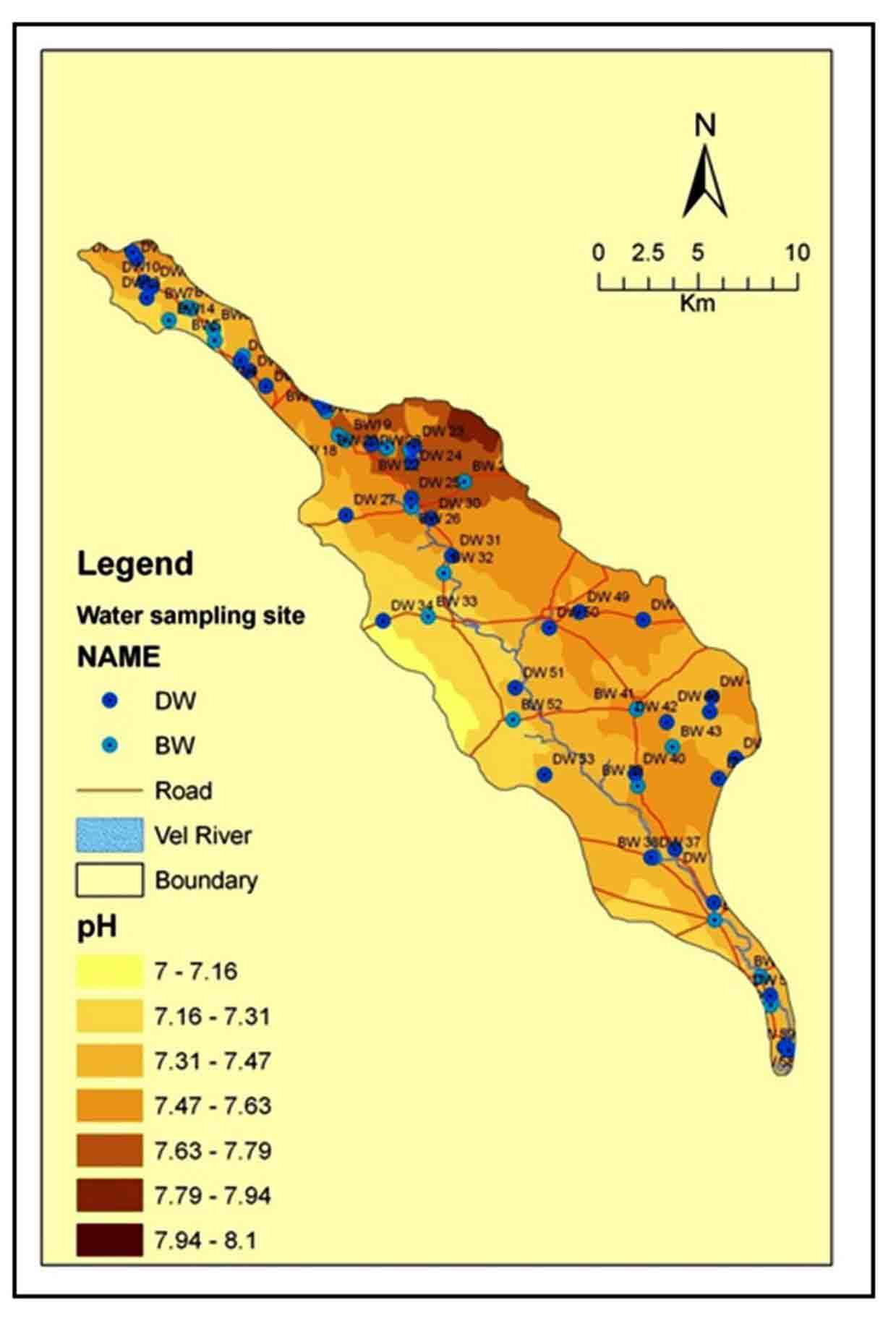
- Figure 4. Spatial variation of pH
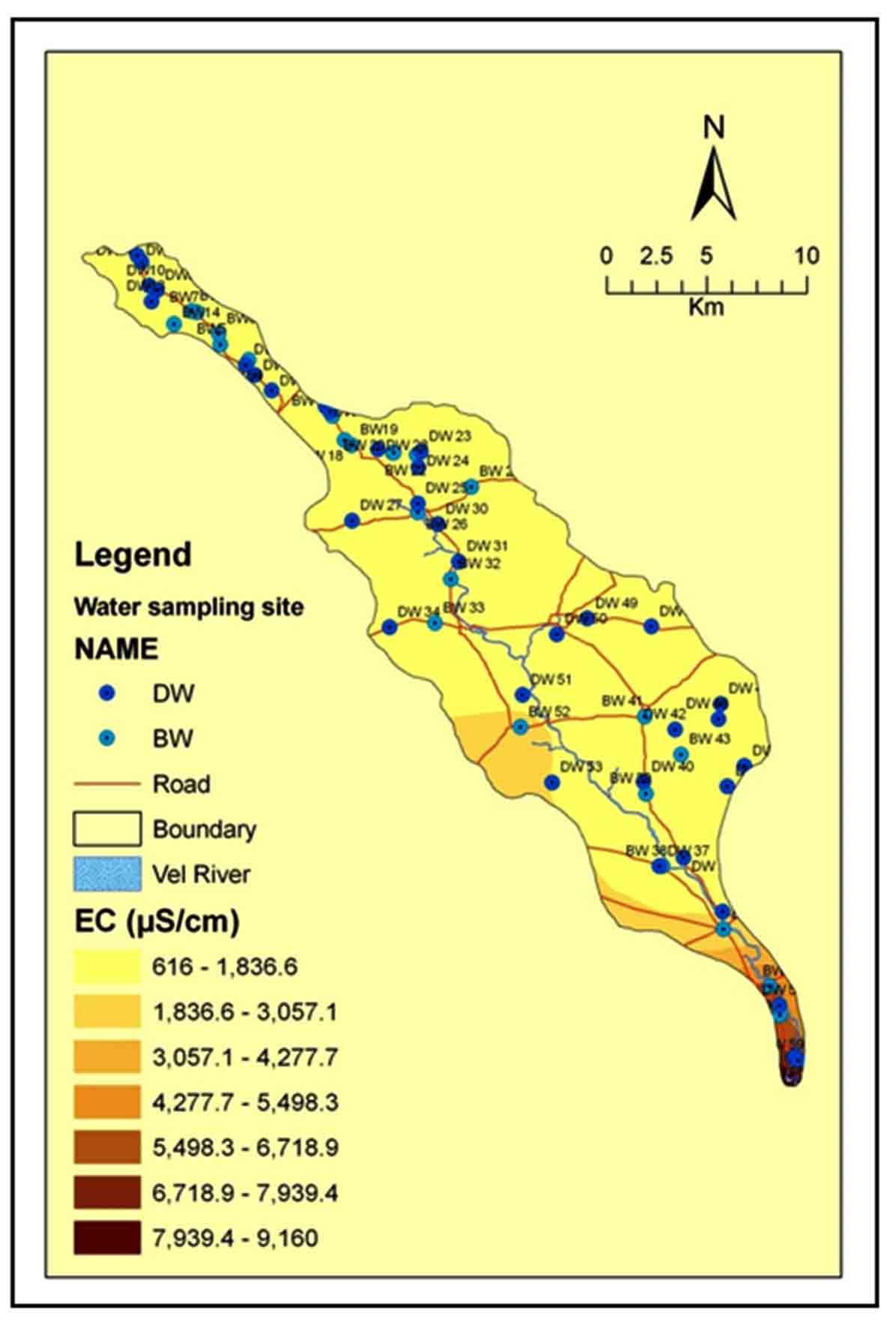
- Figure 5. Spatial variation of EC
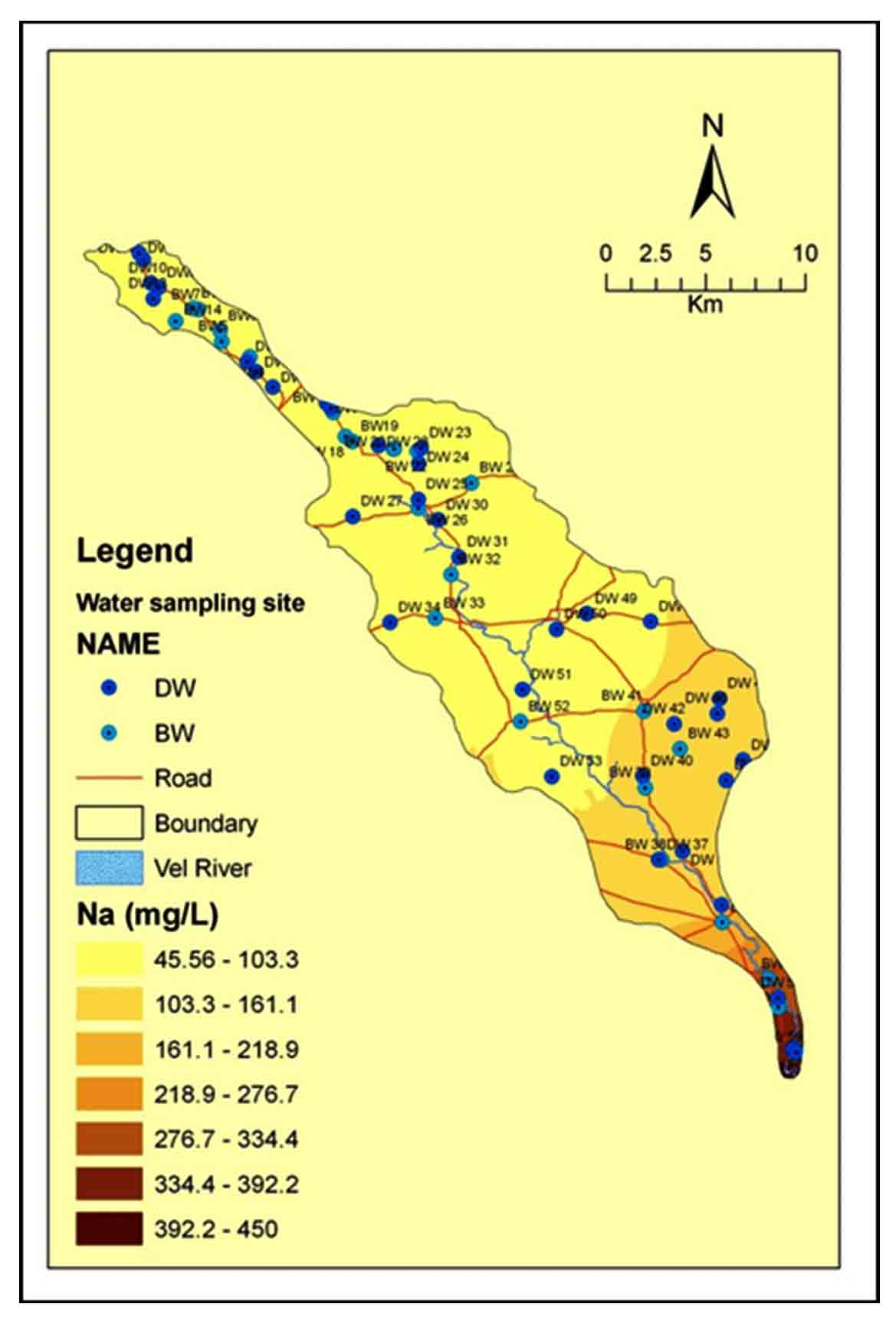
- Figure 6. Spatial variation of Sodium (Na+)
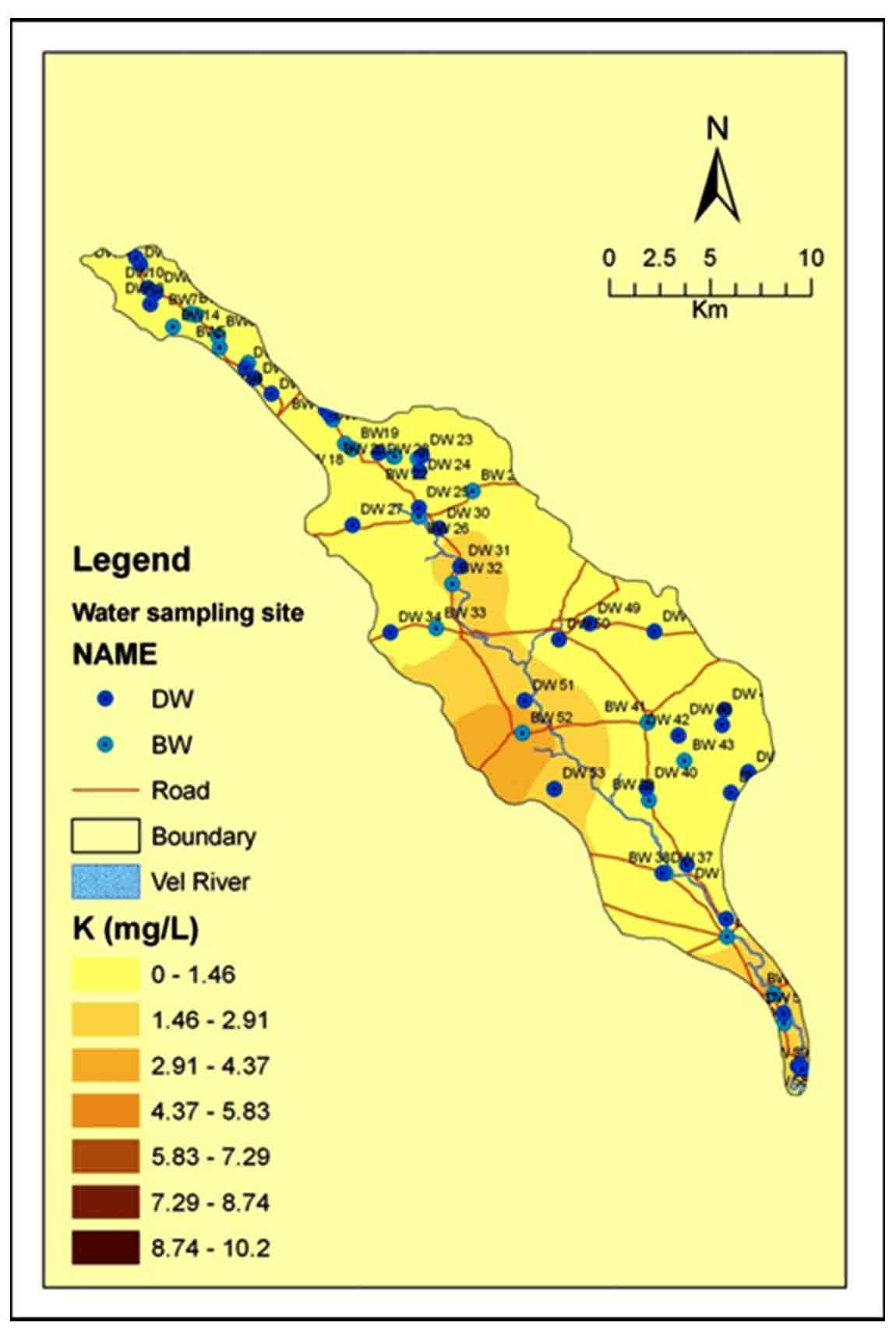
- Figure 7. Spatial variation of Potassium (K+)
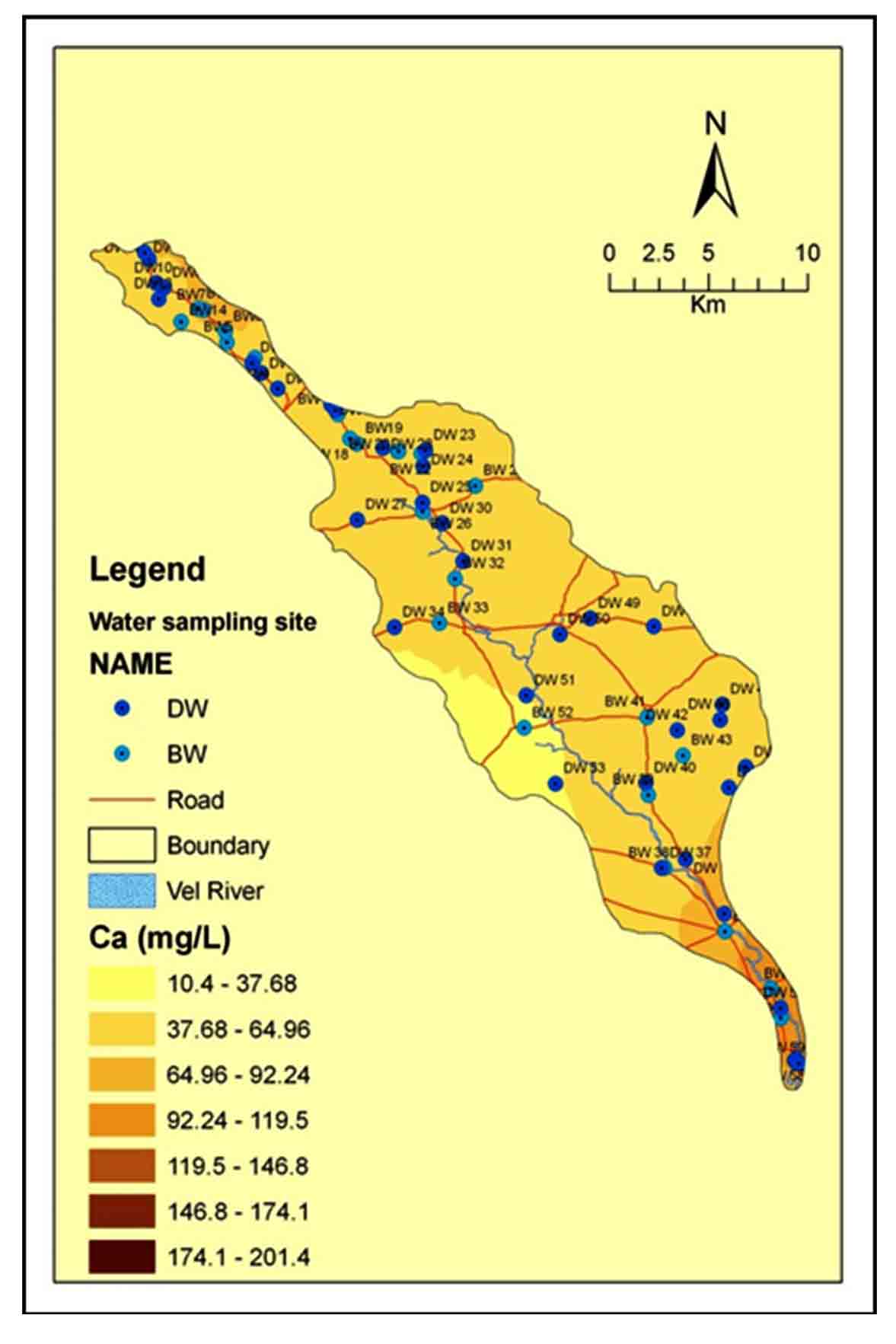
- Figure 8. Spatial variation of Calcium (Ca2+)
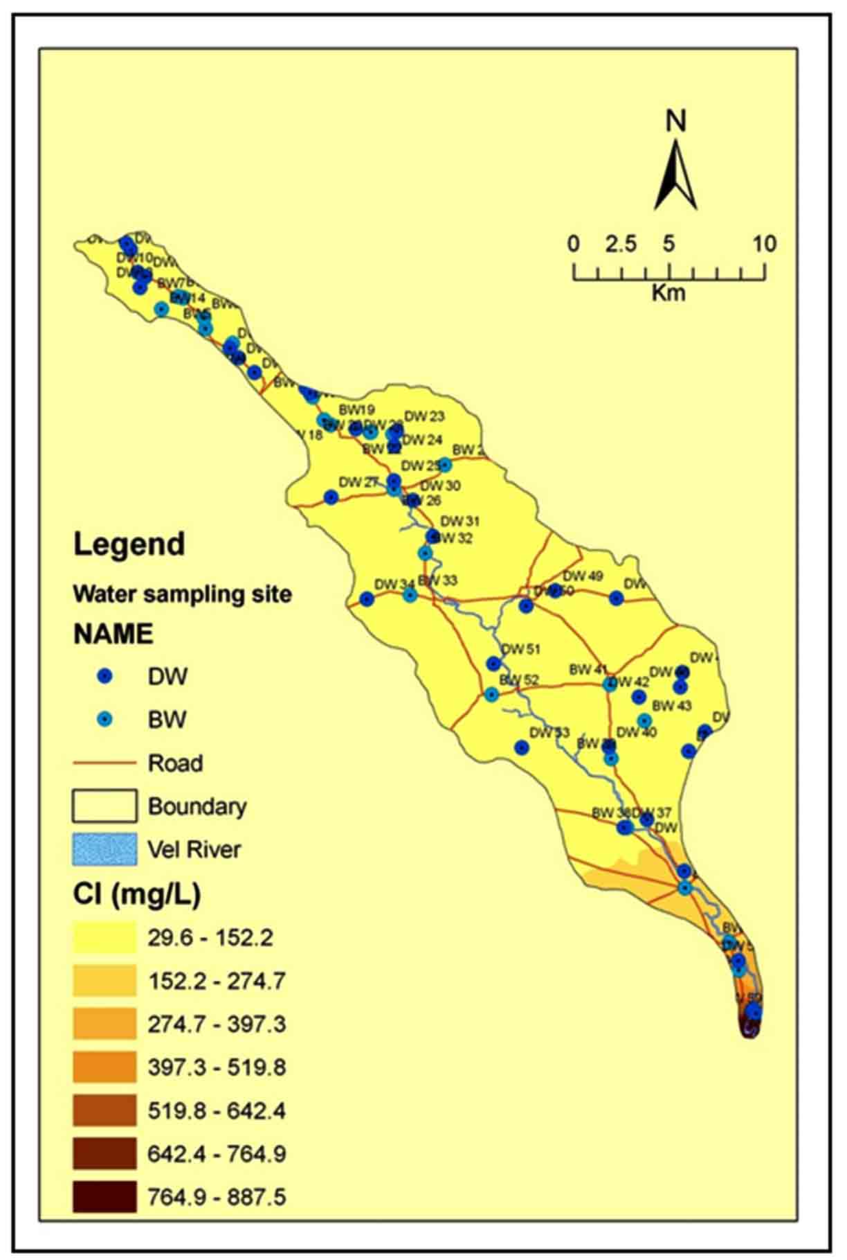
- Figure 10. Spatial variation of Chloride (Cl-)
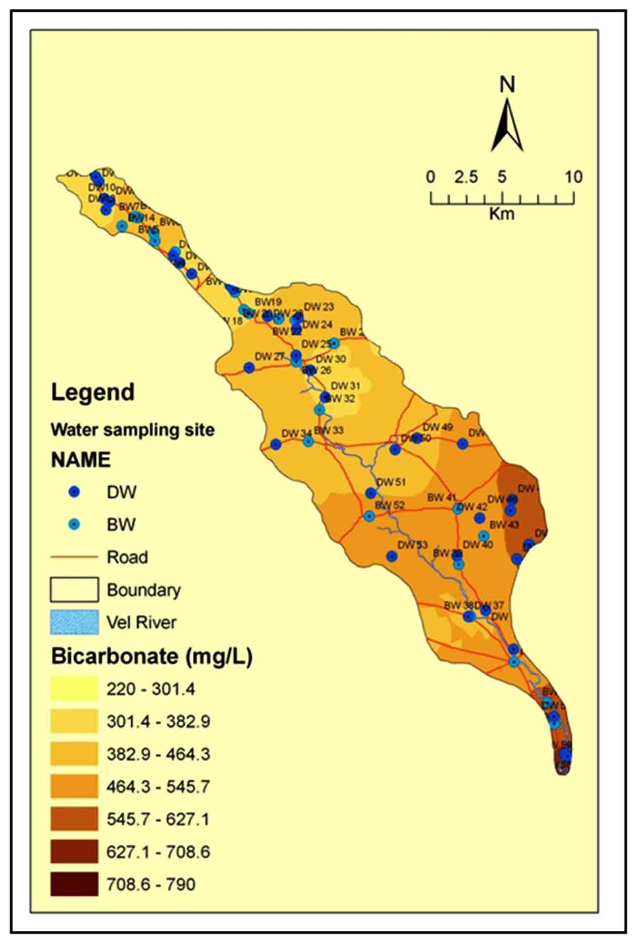
- Figure 11. Spatial variation of Bicarbonate (HCO3-)
- Figure 12. Spatial variation of Sulphate (SO42-)
- Figure 13. A scatter plot of Na+ vs. Cl-
- Figure 14. A scatter plot of Ca2++Mg2+ vs. HCO3-
- Figure 15. A scatter plot of Ca2++Mg2+ vs. SO42-+ HCO3-
- Figure 16. A scatter plot of Ca2++Mg2+ vs. Cl-+ SO42-
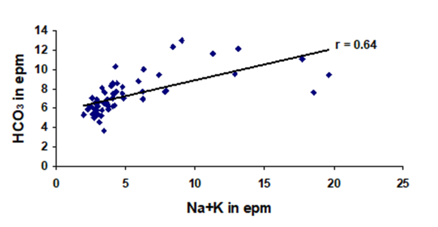
- Figure 17. A scatter plot of Na++K+ vs. HCO3-
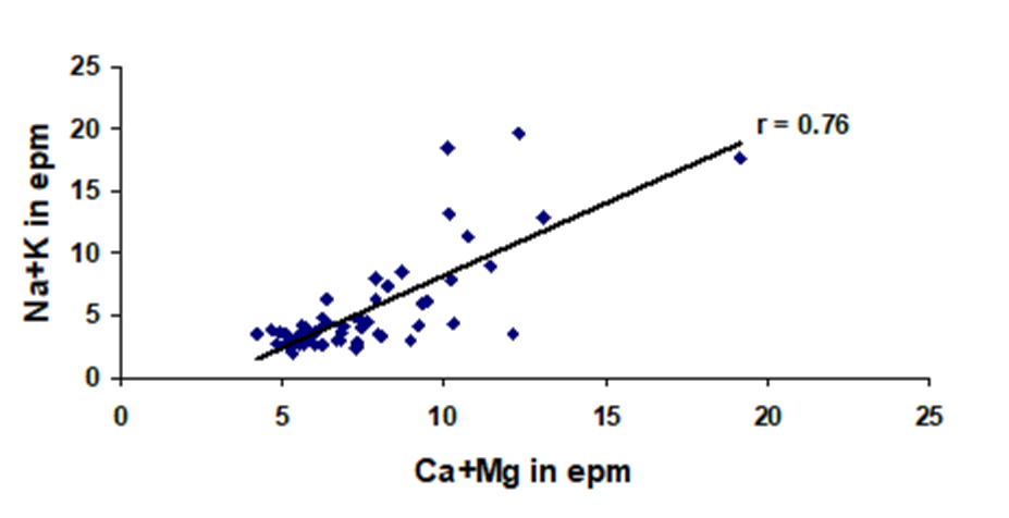
- Figure 18. A scatter plot of Ca2++Mg2+ vs. Na++K+
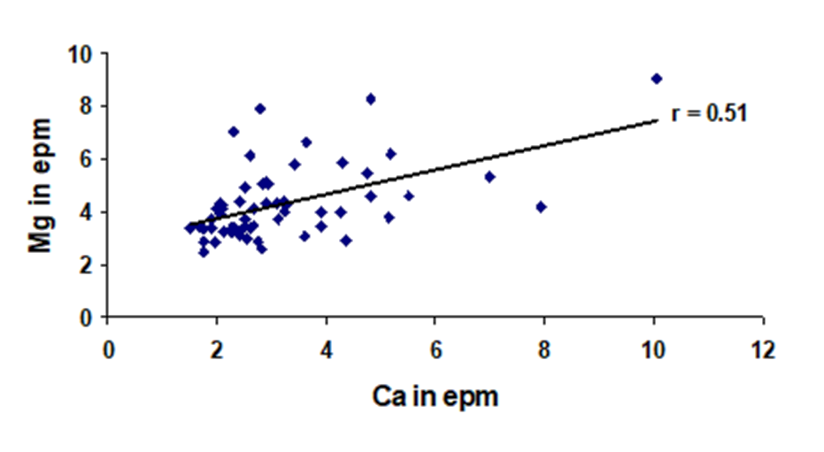
- Figure 19. A scatter plot of Ca2+ vs. Mg2+
- Figure 20. Hydrochemical facies of groundwater on Piper Trilinear Dia…
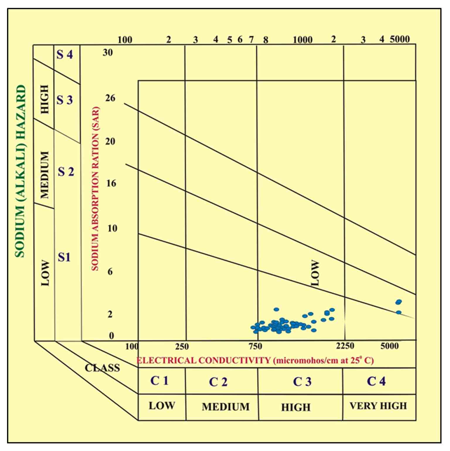
- Figure 21. USSL diagram for classification of irrigation water
Highlights
- Area under study is covered with Deccan Basalt and aquifers are mostly fractured and compact in upper and middle part of the basin.
- Most predominant cations are Na and Ca followed by Mg while in anions HCO3, and Cl are dominant anions than SO4.
- The dominant hydrochemical facies Ca+Mg, Na+K; Cl+SO4 HCO3 facies, found in 83.3 % samples indicating the alkaline earth is exceeding the alkalis and the strong acids exceeds the weak acids.
- The data compared with World Health Organization standards found that pH, Total Hardness (TH) and Magnesium (Mg) of the samples are more % of samples falling above Desirable limit.
- Different parameters like Sodium Absorption Ratio (SAR), Soluble Sodium Percentage (SSP) and Kelly ratio (KR) have been calculated to analyse the quality of water for irrigation.
- In SSP, 33.3 % samples are permissible, while 66.6% samples are doubtful for irrigation purpose.
Abstract
To study the chemistry of major ion in groundwater from Vel (Velu) River basin, sixty (60) samples of dug wells and bore wells were collected and analyzed using standard techniques given by APHA. It shows order of dominance for cations, Na+ > Ca2+ > Mg2+ > K+ and in anionic concentration as HCO3- > Cl- > SO42- in groundwater. The pH of groundwater is slightly alkaline (range: pH 7.0 - 8.1), while average values of Electrical Conductivity (EC) is about 2641 µS/cm indicating high mineralization of groundwater. In general, the cationic concentration (Na+, K+, Ca2+ and Mg2+) of the groundwater increase in the downstream side (from Northwest to South east), suggesting geological control on the composition of groundwater while highest concentration is in lower part of the basin are generally associated with the high salinity. In the major anions, bicarbonate (HCO3-) is higher due to rock-water interaction. Average value of chloride is about of 235 mg/L due to discharge zones along with anthropogenic activities. The geochemical data plotted on Piper Trilinear Diagram is showing dominant hydro-chemical facies: Ca2++Mg2+, Na++ K+, Cl-+ SO42- -HCO3- found in 83.3 % samples indicating the alkaline earth exceeding the alkalis and the strong acids exceeds the weak acids. The pH, Total Hardness (TH) and Magnesium (Mg2+) of the samples show more proportion of samples falling above desirable limit. Otherwise the quality of groundwater is good for drinking. The irrigation indices like SAR, KR and SSP were considered to evaluate groundwater suitability for irrigation. Comparing with SAR parameter all samples are excellent to good for irrigation. In SSP, 33.3 % samples are within permissible, while 66.6% samples are doubtful for irrigation purpose. In KR almost all samples (excluding 04 samples in lower side of basin) are suitable for irrigation. So, variations in climate, geology with anthropogenic activities are modifying the groundwater geochemistry of Vel River Basin.
Keywords Chemical ConcentrationsGeochemistryGroundwaterPhysicochemical ParametersVel River basin
1. Introduction
In freshwater, groundwater is very important source on the earth (Brindha et al., 2011) and it is major source for drinking in the rural parts of the developing nations (Brindha et al., 2010; Wagh et al., 2016). The chemistry of groundwater modifies by natural and anthropogenic activities (Wagh et al., 2018). Rock weathering and its dissolution is the most important mechanism that modifies the chemistry of groundwater (Weijden and Pacheco, 2006; Pawar and Nikumbh, 2007). Along with it, interaction of water with aquifer minerals along the flow path in the sub-surface and evaporation and precipitation of surface waters also modifies its chemistry (Domenico, 1972; Wallick and Toth, 1976; Adimalla et al., 2018; Kadam et al., 2020; Mukate et al., 2020; Kumari and Rai, 2020). Geochemical scatter plots give important clues about the sources of ions and pollution in groundwater (Pawar et al., 2008; Wagh et al., 2018; Wagh et al., 2019; Gaikwad et al., 2020).
Due to rapid rise in and growth of agricultural and industrial sectors and demand of groundwater has increased in many folds (Brindha and Elango, 2014; Adimalla et al., 2018; Wagh et al., 2020). Due to this development, pollution of water bodies has been increasing (Brindha and Elango, 2014; Adimalla et al., 2018). If groundwater contains dissolved ions more than standard limit, then it is harmful and unsuitable for use (Pawar et al., 2008; Brindha et al., 2011; Wagh et al., 2019a; Wagh et al., 2020; Kadam et al., 2020; Mukate et al., 2020). So the quality of groundwater for drinking as well as for irrigation purpose also can be studied comparing it with WHO standards and using different parameters like Sodium Absorption Ratio (SAR), Soluble Sodium Percentage (SSP) and Kelly Ratio (KR), respectively.
In absence of any scientific work in the area under investigation except some government organizations like CGWB (2013) and GSDA (2003) and Gaikwad et al., (2018), it is necessary to find out sources and pathways of migration of these ions in the groundwater.
The objectives of this study are to understand the spatial-temporal distribution of major ion in groundwater as well as to identify the geogenic as well as anthropogenic pollution sources in it and to investigate the groundwater quality for drinking and irrigation purposes.
2. Study Area
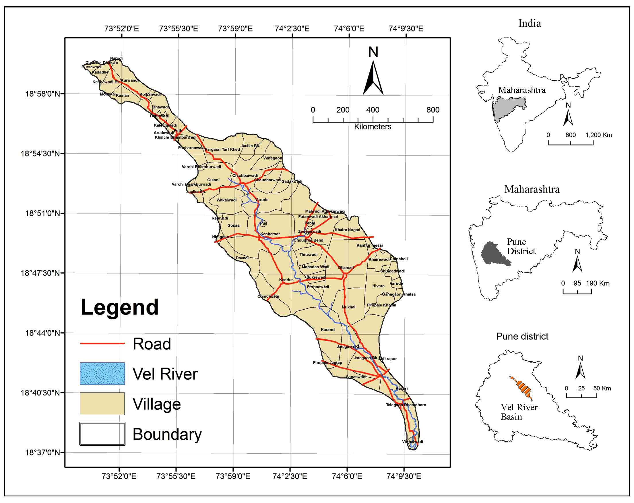
Study area is Vel (Velu) River basin; a small tributary of Bhima River flows through Pune district (Figure 1). It originates near Matewadi and meets to the Bhima River near the Vitthalwadi. Vel River is on the Northern side of Pune city. Major localities in the basin are Shikrapur, Talegaon Dhamdhare, Peth, Wafgaon, Varude, Vitthalwadi and Pargaon. The basin is bound by 73º 50ʹ to 74º 10.5ʹ E longitudes and 18º 37ʹ to 19º 00ʹ N latitudes and it is a part of Survey of India’s (SOI) toposheets No. 47 F/13, 47 J/1 and 47 J/2 of scale 1: 50,000. The study area is about 352.13 sq.km. The major water harvesting structures includes Pargaon and Thitewadi Bhandhra. The average annual precipitation of the basin is about 650 mm (Supekar, 2011). It is also observed that the rainfall is moderately heavy in western part of the study area and decreases rapidly towards lower part of the basin. The temperature ranges from 10 to 32 °C in the basin.
3. Materials And Methods
3.1 Geology
The study area is a part of the Deccan Volcanic Provinces (DVP). The DVP covers an area of more than 500,000 km2, in central and western India (Powar, 1987). The many workers have studied DVP from chemostratigraphy, mineralogy and geochemistry point of view including Beane et al. (1986), Mitchell and Widowson, (1991), Subbarao et al. (1988), Subbarao et al. (1994), Sethna et al. (1996) and Melluso et al. (1999), etc.
The major lithologies exposed in the Vel basin of Lonavala and Diveghat Subgroup of Deccan Trap Supergroup (Figure 2).
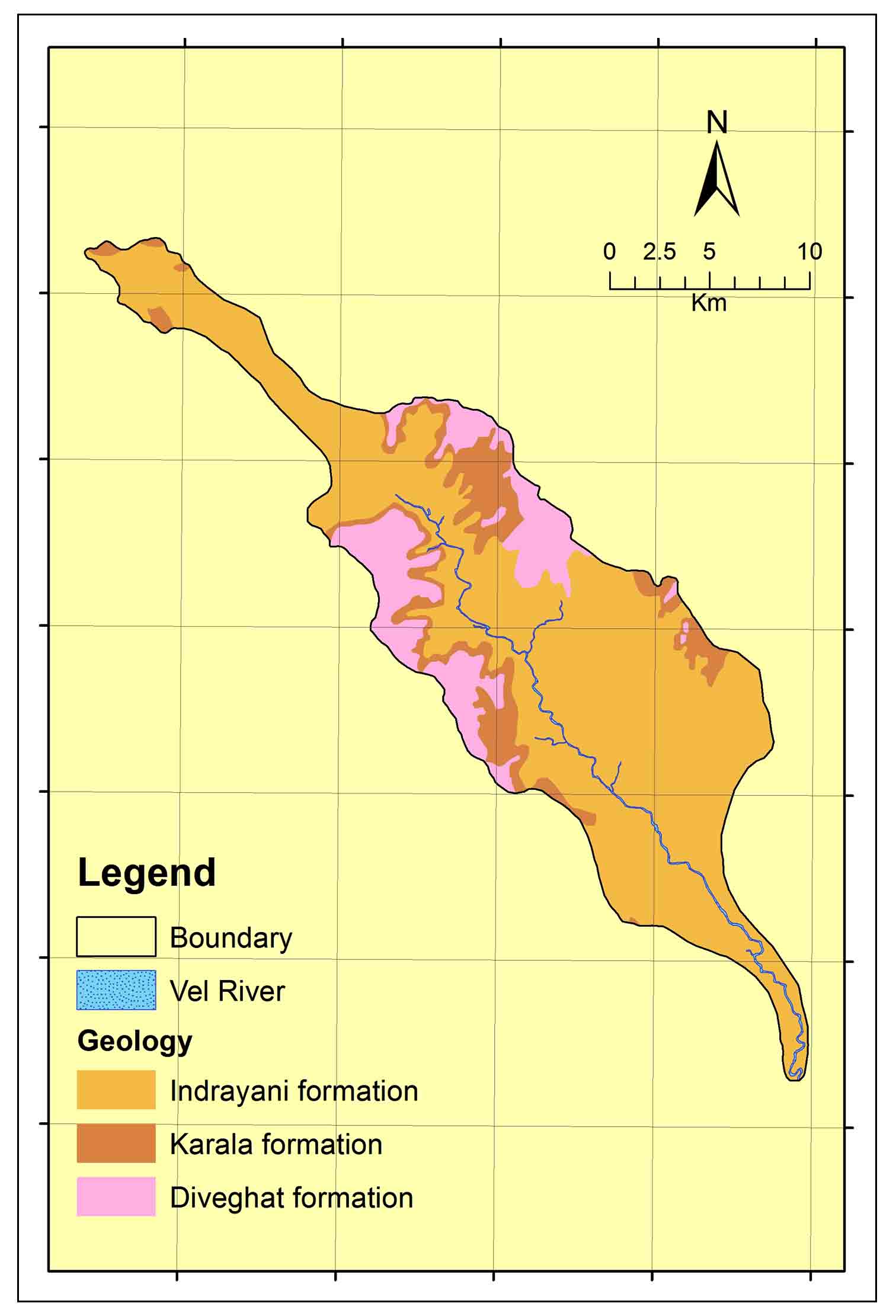
The Indrayani and Karla Formation are part of Lonavala Subgroup while Diveghat Formation is from Diveghat Subgroup (GSI, 2001). Diveghat Formation overlies the Karla Formation. It is exposed in the western and north-eastern regions of the study area. Outcrops of this formation are witnessed on the hills and along the hill slopes above 700 m AMSL (Supekar, 2011). It comprises mainly aphyric simple flows of AA type (GSI, 2001). Lava flows of this formation are characterized by presence of vesicular, plagioclase basalt with medium grained groundmass. It is parted from the upper formation by a geomorphic break (Godbole et al., 1996). The Karla Formation occurs mostly in the central part of basin and overlying the Indrayani Formation. It essentially comprises of compound lava flows revealing pahoehoe characters (GSI, 2001). The Indrayani Formation is exposed in throughout the study area comprising of simple flows covering more than 80% of the total area.
3.2 Water Samples and Chemical Analysis
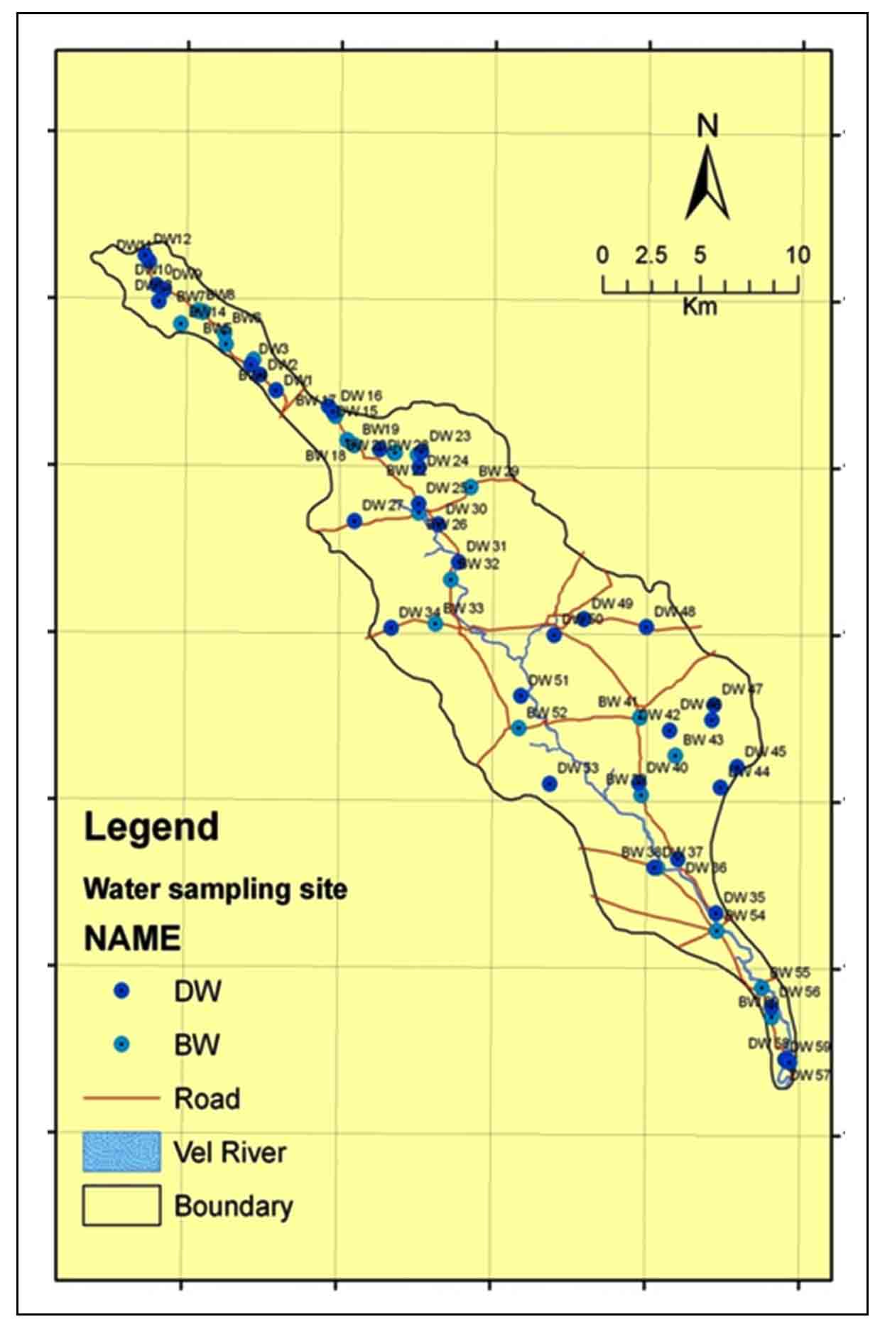
The sampling sites were selected to cover accessible part of the Vel River basin. Sixty (60) groundwater samples of wells and bore wells in different formations were collected using standard procedure for major ions analysis (APHA, 2005; CGWB, 2012; Wagh et al., 2016; Gaikwad et al., 2018; Gaikwad et al., 2020a). The location of water sampling stations in Vel River basin is shown in Figure 3.
Volumetric method was employed for analysis of total alkalinity, total hardness and chloride of water samples from study area are analyzed using the standard methods given by APHA (2005). For the determination of total alkalinity of groundwater samples, acidic-base titration method was used. While for determination of chloride, precipitation argent metric method of titration was used. The complex metric method of titration with EDTA (disodium salt) was used for the analysis of total hardness of groundwater. Sodium (Na+), Potassium (K+) and Calcium (Ca2+) were analyzed on the Photometer (Systronics, Make in India) in the Geochemistry Lab, in the Geology Department of Savitribai Phule Pune University (India). While Magnesium (Mg2+) analyzed by gravimetric analysis with the standard methods (APHA, 2005). Anions (Cl-, HCO3- and SO42- were analyzed on High Performance Ion Chromatography (HPIC) using standard Method (Gaikwad et al., 2020b). The physico-chemical analysis of water sample is shown in the Table 1.
Table 1. Physicochemical analysis of groundwater samples
|
Sr. No |
Ele.(m) |
latitude |
longitude |
pH |
EC |
TDS |
HCO3- |
Na+ |
K+ |
Ca2+ |
Mg2+ |
Cl- |
SO42- |
TH |
CBC% |
SSP |
Kelly ratio |
SAR |
|
DW1 |
779 |
18°56.028' |
73°55.134' |
8 |
715 |
458 |
305 |
62.7 |
0.3 |
39.1 |
35.1 |
72.4 |
13.1 |
242.29 |
1.76 |
36.02 |
0.56 |
1.75 |
|
DW2 |
795 |
18°56.450' |
73°54.653' |
7.6 |
925 |
592 |
350 |
67 |
0.04 |
56.2 |
32.4 |
79.5 |
11.5 |
273 |
1.01 |
34.89 |
0.54 |
1.76 |
|
DW3 |
803 |
18°56.720' |
73°54.394' |
7.5 |
847 |
542 |
330 |
60.2 |
0.08 |
48.3 |
38.4 |
76.7 |
12.3 |
278.66 |
2.25 |
31.99 |
0.47 |
1.56 |
|
BW4 |
801 |
18°56.852' |
73°54.474' |
7.2 |
1198 |
767 |
380 |
97.6 |
1.56 |
65.3 |
51.4 |
122 |
12.6 |
374.82 |
4.6 |
36.09 |
0.56 |
2.19 |
|
BW5 |
816 |
18°57.267' |
73°53.662' |
7.2 |
955 |
611 |
420 |
68.4 |
0.07 |
72.2 |
45.4 |
82.4 |
11.5 |
367 |
4.44 |
30.58 |
0.44 |
1.55 |
|
BW6 |
822 |
18°57.555' |
73°53.614' |
7.1 |
1017 |
651 |
490 |
75.5 |
0.03 |
58.6 |
62.3 |
85 |
13.4 |
402.87 |
2.85 |
29.01 |
0.41 |
1.64 |
|
BW7 |
840 |
18°58.130' |
73°52.993' |
7.2 |
1752 |
1121 |
575 |
170 |
0.15 |
85.5 |
48.5 |
210 |
13.9 |
413.35 |
0.07 |
47.25 |
0.90 |
3.64 |
|
DW8 |
840 |
18°58.171' |
73°52.832' |
7.2 |
1004 |
643 |
375 |
55.8 |
0.11 |
78.3 |
45.3 |
72 |
11.9 |
4.6 |
3.69 |
24.85 |
0.33 |
1.26 |
|
DW9 |
859 |
18°58.720' |
73°51.850' |
7.2 |
838 |
536 |
330 |
68.3 |
0.01 |
53.7 |
50.6 |
72.4 |
12.3 |
342.39 |
4.9 |
30.28 |
0.43 |
1.61 |
|
DW10 |
857 |
18°58.843' |
73°51.625' |
7.3 |
695 |
445 |
375 |
93.9 |
0.17 |
46.6 |
41.5 |
59.4 |
12 |
287.2 |
3.9 |
41.55 |
0.71 |
2.41 |
|
DW11 |
867 |
18°59.496' |
73°51.399' |
8.1 |
726 |
465 |
400 |
64 |
0.05 |
81.5 |
35.9 |
72.4 |
11.5 |
366.21 |
4.8 |
27.55 |
0.38 |
1.45 |
|
DW12 |
850 |
18°59.665' |
73°51.287' |
7.5 |
655 |
419 |
350 |
65.5 |
0.01 |
45.6 |
41.4 |
56.5 |
11.2 |
284 |
5 |
33.45 |
0.50 |
1.69 |
|
DW13 |
841 |
18°58.421' |
73°51.689' |
7.3 |
670 |
429 |
325 |
60.4 |
0.03 |
48.2 |
39.6 |
54 |
11.7 |
294 |
4.2 |
31.72 |
0.46 |
1.56 |
|
BW14 |
845 |
18°57.812' |
73°52.339' |
7.7 |
894 |
572 |
370 |
59.3 |
0.3 |
50.1 |
45.5 |
80.9 |
11.3 |
312.64 |
1.44 |
29.25 |
0.41 |
1.46 |
|
DW15 |
785 |
18°'55.798' |
73°56.540' |
7.3 |
657 |
420 |
325 |
62.8 |
0.07 |
50.2 |
39.5 |
56.8 |
11.1 |
297.64 |
1.8 |
30.43 |
0.44 |
1.56 |
|
DW16 |
785 |
18°55.600' |
73°56.704' |
7.8 |
884 |
566 |
325 |
67.1 |
0.3 |
42.8 |
35.3 |
62.5 |
10.9 |
299.6 |
4.1 |
35.26 |
0.54 |
1.46 |
|
BW17 |
782 |
18°55.349' |
73°56.873' |
7.3 |
1088 |
696 |
275 |
72.1 |
0.07 |
55.4 |
35.3 |
98 |
11.4 |
283.6 |
4.3 |
35.64 |
0.55 |
1.86 |
|
BW18 |
770 |
18°54.698' |
73°57.218' |
7.9 |
853 |
546 |
220 |
78.3 |
0.24 |
35.5 |
30.4 |
118 |
11.3 |
213.24 |
3.42 |
44.46 |
0.80 |
2.33 |
|
BW19 |
763 |
18°54.566' |
73°57.424' |
7.3 |
839 |
537 |
520 |
92.3 |
1.75 |
40.1 |
50.5 |
79.5 |
11.3 |
308.05 |
-3.71 |
39.43 |
0.65 |
2.29 |
|
BW20 |
765 |
18°54.365' |
73°58.596' |
7.7 |
698 |
447 |
420 |
85.6 |
0.07 |
30.3 |
41.4 |
49.7 |
10.7 |
245.94 |
0.75 |
43.11 |
0.76 |
2.38 |
|
BW21 |
765 |
18°54.365' |
73°58.625' |
7.5 |
656 |
420 |
400 |
78.8 |
0.03 |
33.3 |
42.3 |
93.7 |
11.3 |
257.58 |
-4.78 |
40.02 |
0.67 |
2.14 |
|
BW22 |
760 |
18°54.312' |
73°59.281' |
7.6 |
928 |
594 |
450 |
95.1 |
0.86 |
45.6 |
40.5 |
61.1 |
11.5 |
280.61 |
2.23 |
42.51 |
0.74 |
2.47 |
|
DW23 |
750 |
18°54.398' |
73°59.396' |
7.3 |
1249 |
799 |
460 |
78.7 |
3.23 |
58.8 |
61.2 |
85.2 |
11.5 |
398.89 |
4.61 |
30.03 |
0.43 |
1.71 |
|
DW24 |
742 |
18°53.971' |
73°59.321' |
7.9 |
825 |
528 |
355 |
85.7 |
0.32 |
35.5 |
35.2 |
44 |
10.9 |
233.44 |
4.12 |
44.54 |
0.80 |
2.42 |
|
DW25 |
726 |
18°52.997' |
73°59.313' |
8 |
832 |
532 |
390 |
84.7 |
0.18 |
48.8 |
53 |
107 |
10.9 |
340.29 |
4.29 |
35.11 |
0.54 |
2.00 |
|
BW26 |
714 |
18°52.760' |
73°59.317' |
7.4 |
1126 |
721 |
425 |
93.4 |
0.62 |
53.4 |
42.5 |
92.3 |
11.2 |
308.33 |
2.77 |
39.73 |
0.66 |
2.31 |
|
DW27 |
742 |
18°52.521' |
73°57.450' |
7.3 |
1095 |
701 |
520 |
100 |
2.36 |
65.2 |
53.5 |
120 |
11.1 |
382.9 |
-0.34 |
36.36 |
0.57 |
2.23 |
|
BW28 |
801 |
18°54.454' |
73°58.171' |
7.7 |
1447 |
926 |
425 |
111 |
0.02 |
62.2 |
52.4 |
207 |
12.2 |
370.95 |
-3.31 |
39.41 |
0.65 |
2.50 |
|
BW29 |
756 |
18°53.453' |
74°00.832' |
7.9 |
752 |
481 |
360 |
62.3 |
0.03 |
34.4 |
40.4 |
45.4 |
11.2 |
255.14 |
2.67 |
34.74 |
0.53 |
1.70 |
|
DW30 |
709 |
18°52.455' |
73°59.886' |
7.8 |
979 |
627 |
315 |
75.5 |
0.17 |
45.6 |
39 |
82.4 |
11.7 |
274.29 |
4.3 |
37.44 |
0.60 |
1.98 |
|
DW31 |
690 |
18°51.427' |
74°00.480' |
7.2 |
1247 |
798 |
375 |
82.2 |
7.02 |
52.6 |
41.3 |
108 |
12.7 |
301.24 |
1.65 |
37.27 |
0.59 |
2.06 |
|
BW32 |
686 |
18°50.954' |
74°00.273' |
7.3 |
806 |
516 |
350 |
76.4 |
0.03 |
51.2 |
36.3 |
71 |
11.8 |
277.61 |
4.2 |
37.47 |
0.60 |
2.00 |
|
BW33 |
687 |
18°49.764' |
73°59..823' |
7.3 |
616 |
394 |
375 |
68.6 |
0.02 |
38.1 |
45.1 |
51.1 |
11.8 |
280.84 |
4.65 |
34.77 |
0.53 |
1.78 |
|
DW34 |
708 |
18°49.642' |
73°58.522' |
7.1 |
885 |
566 |
500 |
91 |
0.05 |
50.1 |
60.2 |
76.6 |
11.4 |
373.2 |
3.26 |
34.71 |
0.53 |
2.05 |
|
DW35 |
581 |
18°41.998' |
74°08.056' |
7.4 |
1870 |
1197 |
425 |
120 |
0.19 |
96.4 |
56.3 |
29.6 |
12 |
472.22 |
2.67 |
39.72 |
0.66 |
2.40 |
|
DW36 |
592 |
18°43.445' |
74°06.935' |
7.4 |
1081 |
692 |
455 |
95.6 |
0.5 |
62.4 |
45.5 |
112 |
11.9 |
343.2 |
0.73 |
37.78 |
0.61 |
2.25 |
|
DW37 |
591 |
18°43.215' |
74°06.245' |
7.2 |
936 |
599 |
470 |
99 |
1.64 |
42.1 |
52 |
80.9 |
11.1 |
319.37 |
2.43 |
40.26 |
0.67 |
2.41 |
|
BW38 |
617 |
18°43.215' |
74°06.345' |
7.6 |
796 |
509 |
395 |
81.5 |
0.2 |
41 |
48.1 |
76.2 |
11 |
300.58 |
3.75 |
37.13 |
0.59 |
2.05 |
|
BW39 |
611 |
18°45.175' |
74°05.861' |
7.7 |
980 |
627 |
495 |
110 |
0.03 |
58.4 |
52.5 |
93.7 |
12.2 |
361 |
4.45 |
39.95 |
0.67 |
2.53 |
|
DW40 |
620 |
18°45.494' |
74°05.786' |
7.5 |
932 |
596 |
455 |
110 |
0.01 |
42.1 |
56.1 |
90.9 |
12.1 |
311.31 |
3.51 |
43.51 |
0.77 |
2.72 |
|
BW41 |
642 |
18°47.262' |
74°05.807' |
7.4 |
1395 |
893 |
470 |
143 |
1.56 |
41.3 |
52.7 |
139 |
11.4 |
319.98 |
3.15 |
49.33 |
0.97 |
3.48 |
|
DW42 |
641 |
18°46.917' |
74°06.679' |
7.5 |
860 |
550 |
470 |
78.9 |
0.02 |
38.7 |
51.2 |
55.4 |
11.9 |
307.62 |
0.37 |
22.03 |
0.28 |
1.96 |
|
BW43 |
625 |
18°46.240' |
74°06.846' |
7.2 |
1880 |
1203 |
475 |
180 |
2.69 |
78.3 |
48.5 |
78.5 |
12.2 |
395.2 |
-0.9 |
49.81 |
0.99 |
3.95 |
|
DW44 |
610 |
18°45.389' |
74°08.172' |
7.5 |
1670 |
1069 |
530 |
136 |
0.63 |
46 |
86 |
170 |
17.3 |
467 |
4.8 |
38.73 |
0.63 |
2.73 |
|
DW45 |
623 |
18°45.940' |
74°08.652' |
7.8 |
854 |
547 |
745 |
195 |
0 |
52.1 |
74.6 |
200 |
11.1 |
437 |
-2.59 |
49.16 |
0.97 |
4.04 |
|
DW46 |
635 |
18°47.208' |
74°07.905' |
7.4 |
1135 |
726 |
515 |
95.2 |
0.12 |
68.6 |
70.4 |
121 |
11 |
461 |
4.8 |
31.01 |
0.45 |
1.93 |
|
DW47 |
631 |
18°47.613' |
74°07.970' |
7.3 |
1277 |
817 |
610 |
146 |
0.13 |
56.9 |
61.5 |
116 |
11.8 |
395.56 |
2.58 |
44.52 |
0.80 |
3.19 |
|
DW48 |
673 |
18°49.701' |
74°05.991' |
7.5 |
1350 |
864 |
625 |
98.6 |
0.04 |
73 |
80.9 |
95.1 |
12.7 |
515.39 |
4.03 |
29.40 |
0.42 |
1.89 |
|
DW49 |
688 |
18°49.909' |
74°04.159' |
7.6 |
638 |
408 |
320 |
45.6 |
0.02 |
38.1 |
41.3 |
48.3 |
11.8 |
265.09 |
3.01 |
27.24 |
0.37 |
1.22 |
|
DW50 |
666 |
18°49.477' |
74°03.295' |
7.4 |
821 |
525 |
425 |
59.8 |
0.02 |
50.2 |
42.5 |
63.9 |
11.3 |
300.33 |
-2.27 |
30.23 |
0.43 |
1.50 |
|
DW51 |
649 |
18°47.827' |
74°02.331' |
7.3 |
884 |
566 |
355 |
52.6 |
0.02 |
65 |
48.9 |
88 |
11.9 |
363.08 |
4.57 |
23.95 |
0.31 |
1.20 |
|
BW52 |
648 |
18°46.957' |
74°02.269' |
7 |
4850 |
3104 |
790 |
201 |
10.2 |
10.4 |
75.5 |
272 |
13.5 |
570.66 |
-1.12 |
43.51 |
0.77 |
3.68 |
|
DW53 |
635 |
18°45.466' |
74°03.187' |
7.8 |
1450 |
928 |
405 |
69.4 |
0.4 |
43.3 |
46 |
63.9 |
13.1 |
297.6 |
1.46 |
25.25 |
0.34 |
1.70 |
|
BW54 |
585 |
18°41.516' |
74°08.082' |
7.1 |
1748 |
1119 |
470 |
181 |
0.12 |
95.6 |
66.5 |
278 |
12.9 |
512.71 |
4.74 |
43.43 |
0.77 |
3.47 |
|
BW55 |
557 |
18°39.987' |
74°09.403' |
7.1 |
9160 |
5862 |
675 |
402 |
8.5 |
201 |
110 |
888 |
12.7 |
956.6 |
0.63 |
47.79 |
0.92 |
5.66 |
|
DW56 |
558 |
18°39.464' |
74°09.680' |
7.3 |
5580 |
3571 |
460 |
425 |
0.69 |
110 |
56.5 |
610 |
12.4 |
508.15 |
4.48 |
64.64 |
1.83 |
8.22 |
|
DW57 |
572 |
18°38.057' |
74°10.093' |
7.2 |
7690 |
4922 |
575 |
450 |
2.81 |
140 |
64.5 |
827 |
11.8 |
616.36 |
-1.61 |
61.39 |
1.59 |
7.89 |
|
DW58 |
546 |
18°38.058' |
74°10.092' |
7.3 |
4800 |
3072 |
710 |
259 |
1.03 |
56.1 |
96.3 |
301 |
11.9 |
536.96 |
3.91 |
51.25 |
1.05 |
4.84 |
|
DW59 |
549 |
18°37.980' |
74°10.222' |
7.6 |
5800 |
3712 |
740 |
302 |
0.68 |
86.2 |
71.5 |
397 |
12.4 |
509.72 |
-0.57 |
56.33 |
1.29 |
5.82 |
|
BW60 |
570 |
18°39.196' |
74°09.698' |
7.5 |
4940 |
3162 |
580 |
296 |
0.13 |
46.3 |
100 |
372 |
12.3 |
654.16 |
4.34 |
49.63 |
0.99 |
5.04 |
|
Max. |
8.1 |
9160 |
5862 |
790 |
450 |
10.2 |
201 |
110 |
888 |
17.3 |
956.6 |
5 |
64.64 |
1.83 |
8.22 |
|||
|
Min. |
7 |
616 |
394 |
220 |
45.6 |
0 |
10.4 |
30.4 |
29.6 |
10.7 |
4.6 |
-4.78 |
22.03 |
0.28 |
1.2 |
|||
|
Average |
7.41 |
2641 |
1690 |
528 |
176 |
1.44 |
67.2 |
64.4 |
235 |
12.3 |
442.91 |
2.354 |
38.23167 |
0.657 |
2.5755 |
4. Results And Discussions
4.1 Spatial Variation in pH and EC
The high pH reported in the eastern and northern part of the basin while low is in the central parts (Figure 4). The pH is slightly alkaline (range: pH 7.0-8.1) which is due to loss of CO2 and mineral salts precipitation. High EC (9160 µS/cm) is observed towards lower part in the basin, while low EC value (616 µS/cm) is reported in BW-33 in middle part of the basin (Figure 5). So, an average values of EC (2641 µS/cm) is indicating high mineralization of groundwater (Pawar et al., 2008; Gaikwad et al., 2020a).
4.2 Spatial Variation in Cations
Calcium (Ca2+), Magnesium (Mg2+), Sodium (Na+) and Potassium (K+) are the main four cationic constituents in all types of waters (Pawar et al., 2008; Wagh et al., 2016; Gaikwad et al., 2020b).
Increase in Na+ concentration from northwest to southeast due to hydro-geomorphological conditions (e.g., slope) (Figure 6). Low K+ (in Figure 7) concentration in groundwater observed due to non-appearance of K-bearing minerals (Subbarao et al. 1994; Pawar et al., 2008; Gaikwad et al., 2020a); excluding quiet increase in central part (BW-52) is excessive use of fertilizers (Pawar et al., 2008). Concentration of Mg2+ in groundwater ranges from 30.4 to 110.0 mg/L (Figure 9). In lower part of basin, high Mg2+ observed due to high salinity zone (Gaikwad et al., 2018).
Elevated Ca2+ values are found in lower part of the basin (Figure 8). The average, Na+ + Ca2+ representing 75.4 % of total cations signify weathering of felsic minerals such as plagioclase feldspar is major supply from lithologies (Pawar et al., 2008; Wagh et al., 2018; Gaikwad et al., 2020a). While, Ca2+ + Mg2+ values accounts for 51.5 % (range: 28-69%) of the total cations indicating its supply is from olivine and pyroxene (Gaikwad et al., 2020b).
4.3 Spatial Variation in Anions
In anions, Bicarbonate (HCO3-) is the principal anion followed by, Chloride (Cl-) and Sulphate (SO42-).
High values of Bicarbonate (HCO3-) are observed in central and upper parts of the study area while low in the southern side. High values of HCO3- in groundwater (Figure 11) entail abundant supply of CO2 by rainwater recharge and availability of larger surface area for rock-water interaction and vice-versa (Matthess and Harvey, 1982; Drever, 1982; Pawar et al., 2008). Chloride ranges from 29.6 to 888 mg/l with average of 235 mg/L. High concentrations of chloride is observed in the lower part of the basin (Figure 10). Thus, lower and high concentrations of Cl- corresponding with recharge and discharge zones, respectively (Gaikwad et al., 2020b).
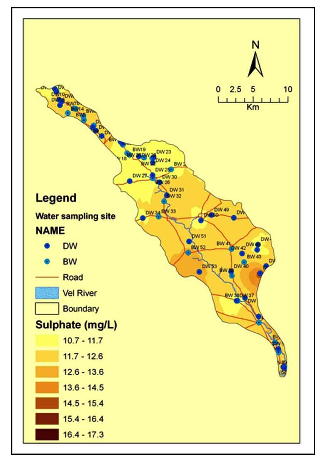
High concentration of chloride (888 mg/L in BW-55), is due to the combination of high evaporation, deeper source and use of fertilizers (Figure 10). High concentrations of SO42- are reported in lower part i.e. south central part, while low concentration is in upper part of the basin (Figure 12). But high concentration in central part may be due to the use of excess fertilizers and agricultural runoff (Pawar et al., 2008; Wagh et al., 2018).
4.4 Geochemical Plots
In study of hydrochemical evolution it is imperative to know geological inputs, agricultural activities, precipitation and climatic condition, that are influencing the chemistry of groundwater (Wagh et al., 2018).
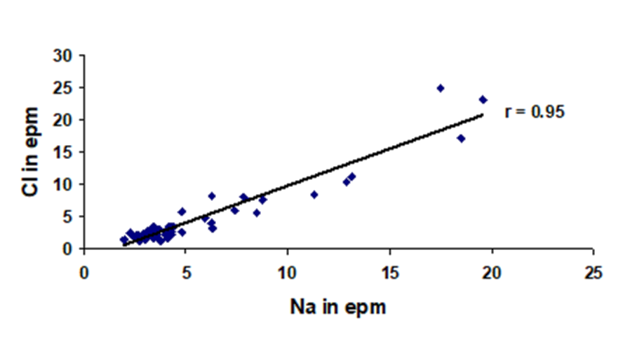
The Na+ vs. Cl- scatter diagram (Figure 13) shows positive correlation (r = 0.95) in post monsoon season indicating combined influence of anthropogenic activities and ion exchange (Gaikwad and Pawar, 2008; Tiwari and Singh, 2014; Wagh et al., 2018; Gaikwad et al., 2020).
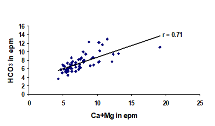
Similarly the cross plot of Ca2++Mg2+ vs. HCO3- (Figure 14) depicts a positive correlation (r = 0.71), indicating influence of mafic minerals on groundwater geochemistry (Sami, 1992; Pawar et al., 2008; Wagh et al., 2018; Gaikwad et al., 2020a). The cross plot Na++K+ vs. HCO3- plots also shows positive correlation (r = 0.64), suggesting that there is a contribution of ions from felsic lithologies in the area (Figure 17) (Pawar et al., 2008; Gaikwad et al., 2020a).
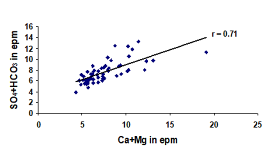
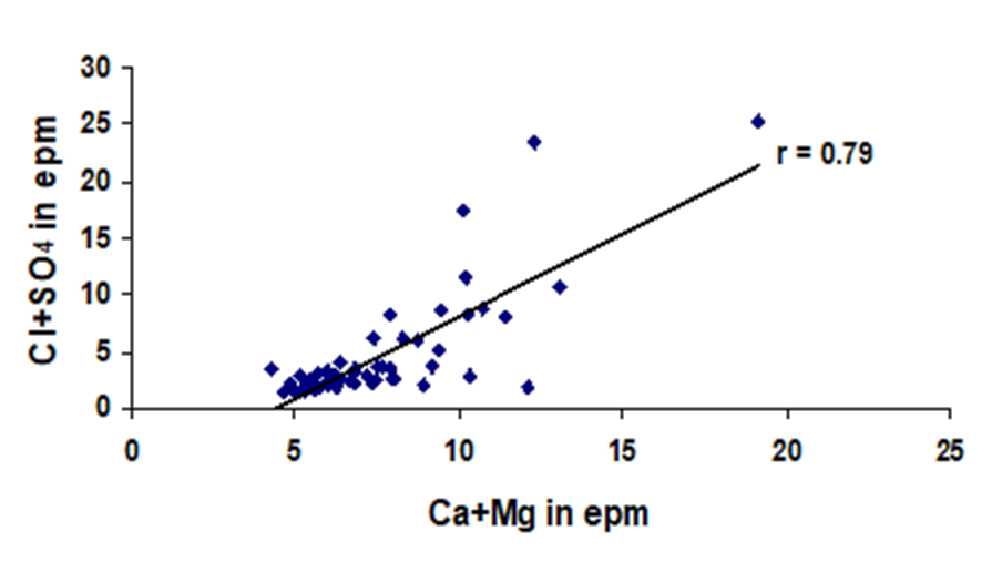
The plots of Ca2+ + Mg2+ vs. Cl- + SO42- (Figure 16) and Ca2+ + Mg2+ vs. SO42- + HCO3- (Figure 15) also show positive correlation (r=0.79 and 0.71, respectively), indicating that these are preferred ion pairs from silicate and carbonate lithologies (Pawar et al., 2008; Wagh et al., 2018; Gaikwad et al., 2020). The correlation between Ca2+ + Mg2+ vs. Na+ + K+ is also positive (r = 0.76), suggesting additions of ion from weathering of silicate rocks in the area (Figure 18) (Pawar et al., 2008; Gaikwad et al., 2020a). The positive correlation coefficients between Ca2+ and Mg2+ (r = 0.51), further confirm this reflecting role of Fe-Mg bearing silicates as their source (Figure 19).
In the (Ca2+ + Mg2+) vs. (HCO3- + SO42-) (Figure 15) scatter diagram, the ionic concentrations in meq/L are falling both the side of equiline indicating both carbonate and silicate weathering. Such a plot also shows that Ca2+ +Mg2+ are in excess of HCO3- possibly pointing to the process of ion exchange reaction (Rajmohan and Elango, 2004; Wagh et al., 2018).
4.5 Hydrochemical Facies
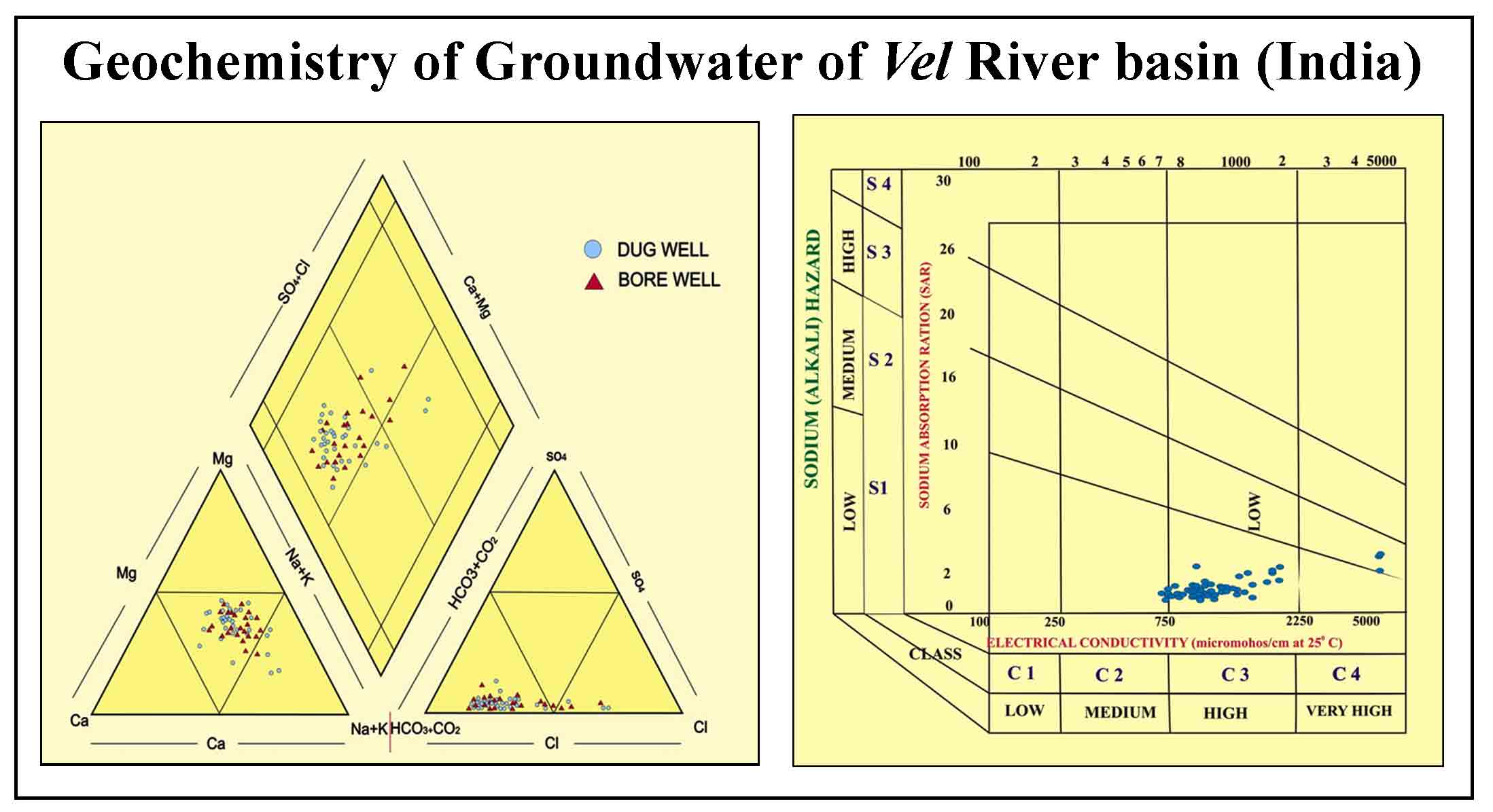
Physiochemical data of groundwater plotted on Piper Trilinear diagram to know its facies (Piper, 1944). The details are shown on figure 20 and given in table 2. The dominant hydrochemical facies Ca2+ + Mg2+, Na+ + K+; Cl- + SO42- HCO3- facies, found in 83.3 % samples indicating the alkaline earth is exceeding the alkalis and the strong acids exceeds the weak acids (Table 2).
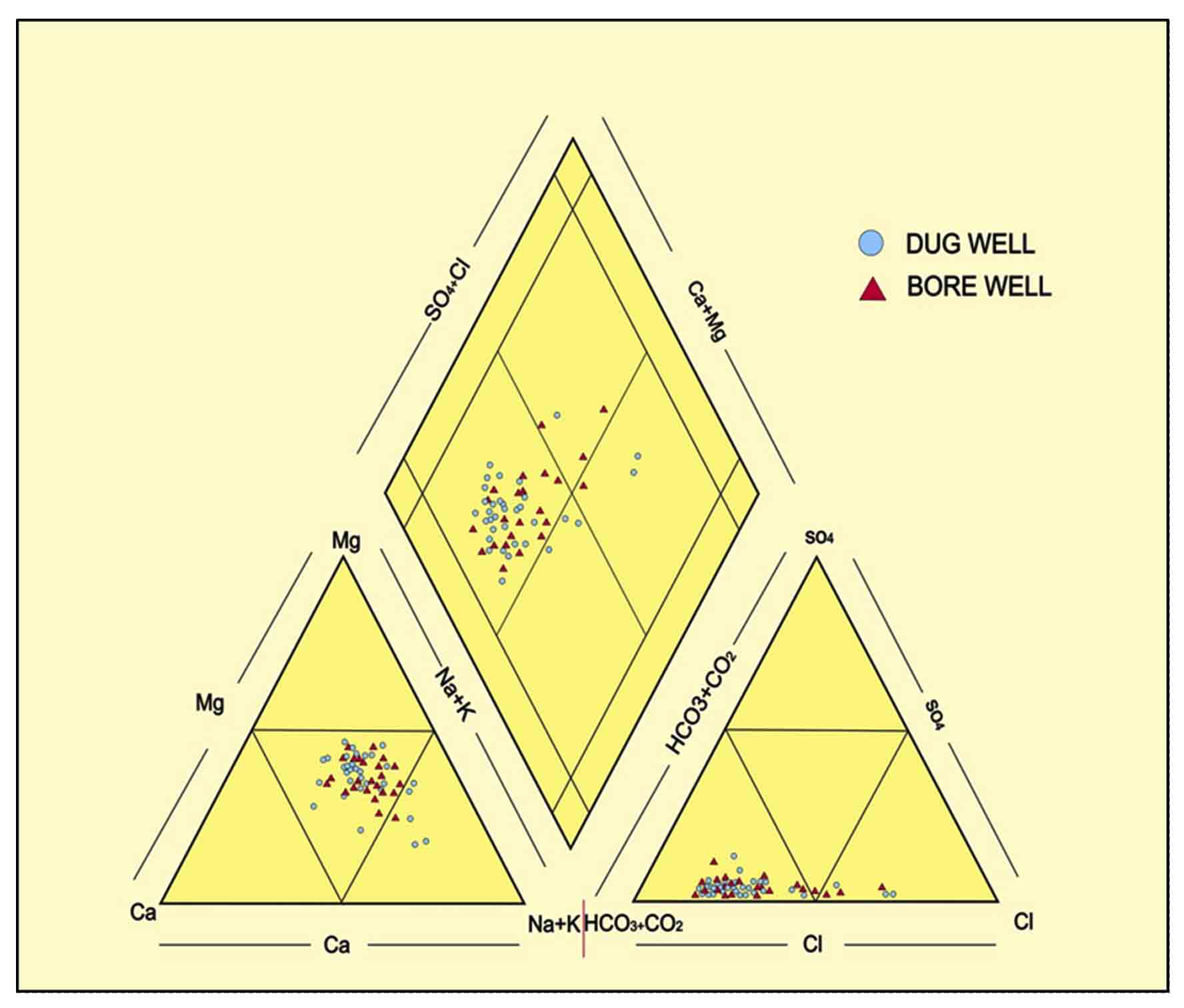
Table 2. Source wise hydro-chemical facies of groundwater
|
Hydrochemical Facies |
Sample No. |
Total |
|
Ca2++Mg2+, Na++K+, HCO3-, Cl-+SO42- |
DW-1, 2 ,3,8 ,9,10, 11, 12, 13, 15, 16, 23, 24,25, 27, 30, 31, 34, 36, 37,40,42,44,46,47,48,49,50,51,53 BW- 4, 5, 6,7,14,17,18,19,20,21,22,26,28, 29, 32, 33, 38, 39, 41, 52 |
DW-30, BW-20 |
|
Na++K+, Ca2++Mg2+, HCO3-, Cl-+ SO42- |
DW-58.59,55 |
DW-3 |
|
Ca2++Mg2+, Na++K+, Cl-+ SO42-, HCO3- |
DW-35 BW-54,55,60 |
DW-1, BW-3 |
|
Na++K+, Ca2++Mg2+, Cl-+ SO42-, HCO3- |
DW-56,57 BW-43 |
DW-2, BW-1 |
4.6 Quality of Groundwater
The quality of water is very important to the mankind, because it has a direct link with human health and welfare. As the study area is falls in the zone of low rainfall, high temperature, and drastic evaporation, which modifies the quality naturally with anthropogenic activities and its pollution (Wagh et al., 2020; Gaikwad et al., 2018).
4.7 Groundwater Quality for Drinking Purposes
The water to be used for drinking purposes should be pure from physical, chemical and biological point of view (Nikumbh, 1997). The data compared with World Health Organization standards found that pH, Total Hardness (TH) and Magnesium (Mg2+) of the samples are more % of samples falling above Desirable limit. Otherwise the quality of groundwater is good for drinking (Table 3).
Table 3. Groundwater qualities for drinking purposes (WHO, 1997)
|
Parameter |
Permissible limits |
Samples above limit (%) |
|
pH |
6.9 - 8.5 |
100 % |
|
EC |
1500 µmhos/cm |
18.3% |
|
TH |
100-500 mg/l |
98.3 % |
|
Na+ |
200-600 mg/l |
31.6 % |
|
K+ |
30 mg/l |
0 % |
|
Ca2+ |
75 - 200 mg/l |
15 % |
|
Mg2+ |
50-150 mg/l |
46.6 % |
|
Cl- |
200- 600 mg/l |
16.6 % |
|
SO42- |
200- 400 mg/l |
0 % |
|
HCO3- |
---- |
---- |
4.8 Groundwater Quality for Irrigation
Total dissolved solids (TDS), proportion of Na+, HCO3- with Ca2+ and Mg2+ and toxic substances present in water are major factors for irrigation quality point of view (Alamary, 2005). Along with these, soil properties, water table depth, slope, climatic condition and crop pattern also affect it. Different parameters like Sodium Absorption Ratio (SAR), Soluble Sodium Percentage (SSP) and Kelly ratio (KR) have been calculated to analyze the quality of water for irrigation. The details of it have been given in Table 1 and 4. It is found that according to the SAR parameters all samples are excellent to good for irrigation. In SSP, 33.3 % samples are permissible, while 66.6% samples are doubtful for irrigation purpose. In KR, almost all samples (excluding 04 samples in lower side of basin) are suitable for irrigation.
Table 4. Irrigation quality parameters
|
Irrigation Quality Parameters (meq/L) |
Range |
Classification |
Number of Samples (%) |
|
Sodium Absorption Ratio (SAR) () \(SAR = {Na^+ \over {\sqrt{Ca^{2+}+ Ma^{2+}} \over 2}}\) |
< 10 10-18 18-26 >26 |
Excellent Good Doubtful Unsuitable |
100 % ---- ---- ---- |
|
Soluble Sodium Percentage (SSP) (Eaton, 1950) \(SSP = (Na^+) \times 100 / Ca^{2+} + Mg^{2+}+ Na^++K^+\) |
< 20 20 - 40 40 - 80 > 80 |
Good Permissible Doubtful Unsuitable |
---- 33.3 % 66.6 % |
|
Kelley’s Ratio (KR) (Kelly, 1951) \(KR= Na^+ / (Ca^{2+} + Mg^{2+})\) |
<1 >1 |
Suitable Unsuitable |
93.3 % 6.6 % |
The US Salinity Laboratory Staff diagram (USSL, 1954) is used to study water quality for irrigation (Figure 21). About 8.3 % samples classified in C2-S1 category indicating low salinity and sodium hazard, while 85.06 % of samples falling in C3-S1 category indicating low salinity hazard but medium sodium hazards. Remaining 6.6 % samples of the lower reaches of the river are falling in C4-S1 zone indicating very high salinity hazard and low sodium hazard. According to Adimalla and Venkatayogi (2018a) high salinity affects the growth of crops and can create nutritional disorders.
5. Summary And Conclusion
To assess the geochemistry of groundwater and its quality for drinking and irrigation purpose from Vel River basin, Sixty (60) samples of Dug well and Bore well were collected and analyzed using standard techniques. It shows order of dominance for cations: Na+ > Ca2+ > Mg2+ > K+ and in anionic concentration as HCO3- > Cl- > SO42- in groundwater. The groundwater pH is slightly alkaline (range: pH 7.0-8.1) while average values of Electrical conductivity (EC) is about 2641 µS/cm indicating high mineralization of groundwater. The cationic values in the groundwater increase in the downstream side (from Northwest to Southeast), suggesting geological control on the composition of groundwater while highest concentration is in lower part of the basin are generally associated with the high salinity. In the major anions, bicarbonate (HCO3-) is higher due to rock-water interaction. Average value of chloride in is about of 235 mg/L due to discharge zones along with anthropogenic activities. High concentrations of SO42- are reported in lower and central part of the basin may be due to the use of excess fertilizers and agricultural runoff. The Na+ vs. Cl- scatter diagram shows positive correlation (r=0.95) indicating combined influence of anthropogenic activities and ion exchange mechanism. Similarly the cross plot of and Ca2+ + Mg2+ vs. HCO3- depicts a positive correlation (r=0.71), indicating influence of mafic minerals on groundwater geochemistry. The cross plot Na+ + K+ vs. HCO3- plots also shows positive correlation (r=0.64), suggesting that there is a contribution of ions from felsic lithologies in the area. The plots of and Ca2+ + Mg2+ vs. Cl- + SO4 and Ca2+ + Mg2+ vs. SO4 + HCO3- also showing positive correlation (r = 0.79 and 0.71 respectively), indicating that these are preferred ion pairs from silicate and carbonate lithologies. The geochemical data plotted on Piper Trilinear Diagram showing The dominant hydrochemical facies Ca2+ + Mg2+, Na++ K+; Cl- + SO42- HCO3- facies, found in 83.3 % samples indicating the alkaline earth is exceeding the alkalis and the strong acids exceeds the weak acids. In drinking water quality, pH, Total Hardness (TH) and Magnesium (Mg2+) of the samples are showing more % of samples falling above desirable limit. Otherwise the quality of groundwater is good for drinking. The irrigation quality indices SAR, KR and SSP were considered to evaluate groundwater suitability for irrigation. Study of SAR parameter showed that all samples are excellent to good for irrigation. In SSP, 33.3 % samples are permissible, while 66.6 % samples are doubtful for irrigation purpose. In KR almost all samples (except 04 samples i.e. 6.6 % in lower side of basin) are suitable for irrigation. In nutshell, groundwater geochemistry of Vel River Basin modified due to variations in climate, geology and anthropogenic activities in the basin.
Conflict of interest
The authors do not have any conflicts of interest.
Acknowledgements
S. K. Gaikwad acknowledges the Head, Department of Geology, Savitribai Phule Pune University (SPPU), Pune (India) for making available all research facility. Present work is financially supported by BCUD, Savitribai Phule Pune University (Proposal No: 13SCI001306), Pune, India.
Abbreviations
APHA: American Physical Health Association; BW: Bore Well; DW: Dug Well; CGWB: Central Ground Water Board; DVP: Deccan Volcanic Provinces; GSDA: Groundwater Survey and Development Agency; GSI: Geological Survey of India; HPIC: High Performance Ion Chromatography; KR: Kelly ratio; SSP: Soluble Sodium Percentage; SAR: Sodium Absorption Ratio; TH: Total Hardness; USDA: United States Department of Agriculture; USSL: US Salinity Laboratory Staff diagram; WHO: World Health Organization.
Article information
- Received
- 20 Aug 2020
- Revised
- 7 Nov 2020
- Accepted
- 8 Nov 2020
- Published
- 13 Nov 2020
- Handling editor
- Dr. Pramodkumar Hire
- Journal
- Hydrospatial Analysis, ISSN 2582-2969
References
-
Adimalla, N and Venkatayogi, S., 2018a.Geochemical characterization and evaluation of groundwater suitability for domestic and agricultural utility in semi-arid region of Basara, Telangana state, South India. Applied Water Science, 8, 44.
Crossref -
Adimalla, N., Li, P. and Venkatayogi, S., 2018. Hydrogeochemical evaluation of groundwater quality for drinking and irrigation purposes and integrated interpretation with water quality index studies. Environmental Processes, 5 (2), 363-383.
Crossref -
Alamary, A. S., 2005. An integrated approach for groundwater exploration in the lower part of Wadi Meifaah, Republic of Yemen. Unpublished PhD. Thesis, Univ. of Pune, India, 1-136.
-
APHA [American Physical Health Association], 2005. Standard methods for the examination of water and wastewater, 21st Ed. American Public Health Association, New York.
-
Beane, J. E., Turner C. A., Hooper P. R., Subbarao .K. V., and Walsh, J. N., 1986. Stratigraphy, composition and form of the Deccan Basal, Western Ghats, India, Bull. Volcanol, 48, 61-83.
Crossref -
Brindha, K. and Elango, L., 2014. Soil and groundwater quality with reference to nitrate in a semiarid agricultural region. Arabian Journal of Geosciences, 7, 4683-4695.
Crossref -
Brindha, K., Rajesh, R., Murugan, R. and Elango, L., 2011. Fluoride contamination in groundwater in parts of Nalgonda District, Andhra Pradesh, India. Environmental Monitoring and Assessment, 172, 481-492.
Crossref -
Brindha, K., Rajesh, R., Murugan, R., and Elango, L., 2010. Natural and anthropogenic influence on the fluoride and nitrate concentration of groundwater in parts of Nalgonda district, Andhra Pradesh, India. Journal of Applied Geochemistry, 12 (2), 231-241.
-
CGWB [Central Groundwater Board], 2012. Guide Manual: Water and Wastewater Analysis, 1-189.
-
CGWB [Central Groundwater Board], 2013. Groundwater information, Pune district, Maharashtra. Technical Report, 1810/DBR/2009.
-
Domenico, P. A., 1972. Concepts and models in ground-water hydrology. New York: McGraw-Hills.
-
Drever, J. I., 1982. The Geochemistry of Natural Waters. Prentice Hall, 1-182.
-
Eaton, F. M., 1950. Significance of carbonates in irrigation waters. Soil Sci, 69(2), 123-134.
-
Gaikwad, S. K and Pawar, N. J., 2008. Spatio-temporal geochemical distinctiveness of ground waters allied to lithological diversity in the area between Karli and Terekhol Rivers, Southern part of Coastal Maharashtra, India. International Groundwater Conference on Groundwater dynamics and global change, Organized by University of Rajasthan, Jaipur, March, 2008.
-
Gaikwad, S. K., Gaikwad, S. P., Date, D. V., Borhade, S. T., Kandekar, A. M., Supekar, A. H., Bhagat, R. S., Kambale, P. N., Madale, R. B., Raut, T. P. and Kadekar, O. S., 2018. Groundwater quality analysis of an emerging part of suburb of Pune Metropolitan Region, Maharashtra, India using GIS and Remote Sensing Techniques. Hydrospatial Analysis, 2 (2), 91-101.
Crossref -
Gaikwad, S. K., Gaikwad, S. P., Meshram, D. C., Wagh, V. M., Kandekar, A. M. and Kadam, A. K., 2020c. Geochemical mobility of ions in groundwater from the tropical western coast of Maharashtra, India: Implication to groundwater quality. Environment, Development and Sustainability, 22, 2591-2624.
Crossref -
Gaikwad, S. K., Kadam, A. R., Ramgir, R. R., Kashikar, A. S., Wagh, V. M., Kandekar, A. M., Gaikwad, S. P., Madale, R. B., Pawar, N. J. and Kamble, K. D., 2020b. Assessment of the groundwater geochemistry from a part of west coast of India using statistical methods and water quality index. HydroResearch, 3, 48-60.
Crossref -
Godbole, S. M., Rana, R. S. and Natu, S. R., 1996. Lava stratigraphy of Deccan basalts of western Maharashtra. Gondwana Geological Magazine Spl. Publ. 2, 125-134.
-
GSDA [Groundwater Survey and Development Agency], 2003. Systematic Hydrological Survey reports Groundwater Survey Development Agency (unpublished).
-
GSI [Geological Survey of India], 2001. District Resource Map of Pune.
-
Kadam, A., Wagh, V., Umrikar, B and Sankhua, R., 2020. An implication of boron and fluoride contamination and its exposure risk in groundwater resources in semi‑arid region, Western India. Environment, Development and Sustainability, 22, 7033-7056.
Crossref -
Kelley, W. P., 1951. Alkali Soils-Their Formation, Properties and Reclamation. Reinhold Publication, New York.
-
Kumari, M. and Rai, S, C., 2020. Hydrogeochemical evaluation of groundwater quality for drinking and irrigation purposes using water quality index in semi arid region of India. Journal of Geological Society of India, 95 (2), 159-168.
Crossref -
Matthess, G., and Harvey, J. C., 1982. The properties of groundwater, John Wiley and Sons, New York, 1-397.
-
Melluso, L., Sethna, S.F., Morra, V., Khateeb, A. and Javeri, P., 1999. Petrology of mafic dyke swarm of the Tapti River in the Nandurbar area, Deccan Volcanic Province, Memoir Geological Society of India, 43(1), 735-738.
-
Mitchell, C. and Widdowson, M., 1991. A geological map of the southern deccan trap, India and its structural implications. Journal of Geological Society of London, 148, 495 - 505.
Crossref -
Mukate, S, V., Panaskar, D, B., Wagh, V, M and Baker, S, J., 2020. Understanding the influence of industrial and agricultural land uses on groundwater quality in semiarid region of Solapur, India. Environment, Development and Sustainability 22, 3207-3238.
Crossref -
Nikumbh, J. D., 1997. Geochemistry of groundwaters from Behedi basin, District-Nasik, Maharashtra. Unpubl. Ph.D. Thesis, University of Pune, India, 1-153.
-
Pawar, N. J. and Nikumbh, J. D., 2007. Mass Balance Modelling of Groundwater’s from shallow basaltic alluvial aquifers of Behedi Basin, Nasik District, Maharashtra. Gondwana Geological Magazine, 11, 23-34.
-
Pawar, N. J., Pawar, J. B., Kumar, S. and Supekar, A., 2008. Geochemical eccentricity of ground water allied to weathering of basalts from the Deccan Volcanic Province, India: Insinuation on CO2 consumption. Aquatic Geochemistry, 14(1), 41-71.
Crossref -
Piper, M., 1944. A graphic procedure in the geochemical investigation of water analysis; American Geo-physic. Union Trans, 25, 915-923.
Crossref -
Powar, K. B., 1987. Evolution of the Deccan Volcanic Province. Presidential Address, (74th Session), Geol. and Geog. Section, Ind. Sci. Cong., 1-29.
-
Rajmohan, N. and Elango, L., 2004. Identification and evolution of hydrogeochemical processes in the groundwater environment in an area of the Palar and Cheyyar River Basins, Southern India. Environmental Geology, 46(1), 47-61.
Crossref -
Richards, L. A., 1954. Diagnosis and improvement of saline and alkali soils. Soil. Sci. 78(2), 154.
-
Sami, K., 1992. Recharge mechanisms and geochemical processes in a semi-arid sedimentary basin, Eastern Cape, South Africa. Journal of Hydrology, 139(1-4), 27-48.
Crossref -
Sethna, S. F., Ateeq, K. and Javeri, P., 1996. Petrology of basic Intrusive in the Deccan Volcanic Province South of Tapti Valley and their comparison with those along the west Coast. Gondwana Geological Magazine, 2, 225-232.
-
Subbarao, K. V., Chandrashekharam, D., Navaneethakrishanan, P. and Hooper, P. R., 1994. Stratigraphy and Structure of Parts of the Central Deccan Basalt Province: Eruptive Models. Volcanism, 321 - 332.
-
Subbarao, K. V., Ramasubbareddy, N. and Prasad, C.V.R.K., 1988. Geochemistry and Palaeomagnetism of dykes from Mandaleshwar region, Deccan Basaltic Province. Geological Society of India, Mem.10, 225-233.
-
Supekar, A. H., 2011. Occurrence and distribution of heavy metals in the groundwater resources of Pune Metropolitan area: A study based on GIS technique. Unpublished Ph. D Thesis, University of Pune, 1-256.
-
Tiwari, A. K. and Singh, A. K., 2014. Hydrogeochemical investigation and groundwater quality assessment of Pratapgarh district, Uttar Pradesh. Journal of the Geological Society of India, 83(3), 329-343.
Crossref -
USSL [United States Salinity Laboratory Staff], 1954. Diagnosis and improvement of saline and alkali soils, Handbook 60. US Department of Agriculture, New York.
-
Wagh, V. M., Mukate, S. V., Muley A. A., Kadam, A, K. Panaskar, D. B. and Varade, A. M., 2020. Study of groundwater contamination and drinking suitability in basaltic terrain of Maharashtra, India through PIG and multivariate statistical techniques. Journal of Water Supply: Research and Technology-Aqua, 69 (4), 398-414.
Crossref -
Wagh, V. M., Mukate, S. V., Panaskar, D. B., Muley A. A. and Sahu, U.L., 2019. Study of groundwater hydrochemistry and drinking suitability through Water Quality Index (WQI) modelling in Kadava river basin, India. SN Applied Sciences, 1, 1251.
Crossref -
Wagh, V. M., Panaskar, D. B., Aamalawar, M. L and Lolage, Y.P., 2018. Hydrochemical characterisation and groundwater suitability for drinking and irigation uses in semiarid region of Nashik, Maharashtra, India. Hydrospatial Analysis, 2(1), 43-60.
Crossref -
Wagh, V. M., Panaskar, D. B., Jacobs, J, A., Mukate, S. V., Muley A. A. and Kadam, A, K., 2019a. Influence of hydro-geochemical processes on groundwater quality through geostatistical techniques in Kadava River basin, Western India. Arabian Journal of Geosciences, 12, 7.
Crossref -
Wagh, V. M., Panaskar, D. B., Varade, A. M., Mukate, S. V., Gaikwad, S. K., Pawar, R. S. Muley A. A. and Aamalawar, M. L., 2016. Major ion chemistry and quality assessment of the groundwater resources of Nanded tehsil, a part of southeast Deccan Volcanic Province, Maharashtra, India. Environmental Earth Sciences, 75(21), 1418.
Crossref -
Wallick, E. I. and Toth, J., 1976. Methods of regional groundwater flow analysis with suggestions for the use of environmental isotope and hydrochemical data in groundwater hydrology. 37-64, Vienna: IAEA.
-
Weijden, C. H., Van der. and Pacheco, F. A. L., 2006. Hydrogeochemistry in the Vogue River basin (central Portugal): Pollution and chemical weathering. Applied Geochemistry, 21(4), 580-613.
Crossref -
WHO [World Health Organization], 1997. International standards for drinking water. Geneva.