Article Title :
Assessment and Modeling of Groundwater Potential Zones by using Geospatial and Decision-making approaches: A case study in Anantapur district, Andhra Pradesh, India 

5 (2021)
34-44
AHP , GIS , Ground Water Potential Zones , Semi-Arid region




Freshwater scarcity is a major issue in Rayalaseema region in Andhra Pradesh (India). Groundwater is the primary source of drinking and irrigation water in Anantapur district, Andhra Pradesh, India. Therefore, it is important to identify areas having groundwater potential; however, the current methods of groundwater exploration consume a lot of time and money. Analytic Hierarchy Process (AHP)-based spatial model is used to identify groundwater potential zones in Anantapur using remote sensing and GIS-based decision support system. Thematic layers considered in this study were geology, geomorphology, soils, land use land cover (LULC), lineament density (LD), drainage density (DD), slope, and rainfall. According to Saaty’s AHP, all these themes and individual features were weighted according to their relative importance in groundwater occurrence. Thematic layers were finally combined using ArcGIS to prepare a groundwater potential zone map. The high weighted value area was considered a groundwater prospecting region. Accordingly, the GWPZ map was classified into four categories: very good, good, moderate, and poor. The very good GWPZ area is 77.37 km2 (24.93%) of the total study area. The northeastern and southeastern sections of the study area, as well as some medium patches in the center and western regions, are covered by moderate GWPZs, which cover an area of 53.07 km2 (17.10%). However, the GWP in the study area’s central, southwestern, and northern portions is poor, encompassing an area of approximately 79.31 km2 (25.56%). Finally, RS and GIS techniques are highly effective and useful for identifying GWPZs.
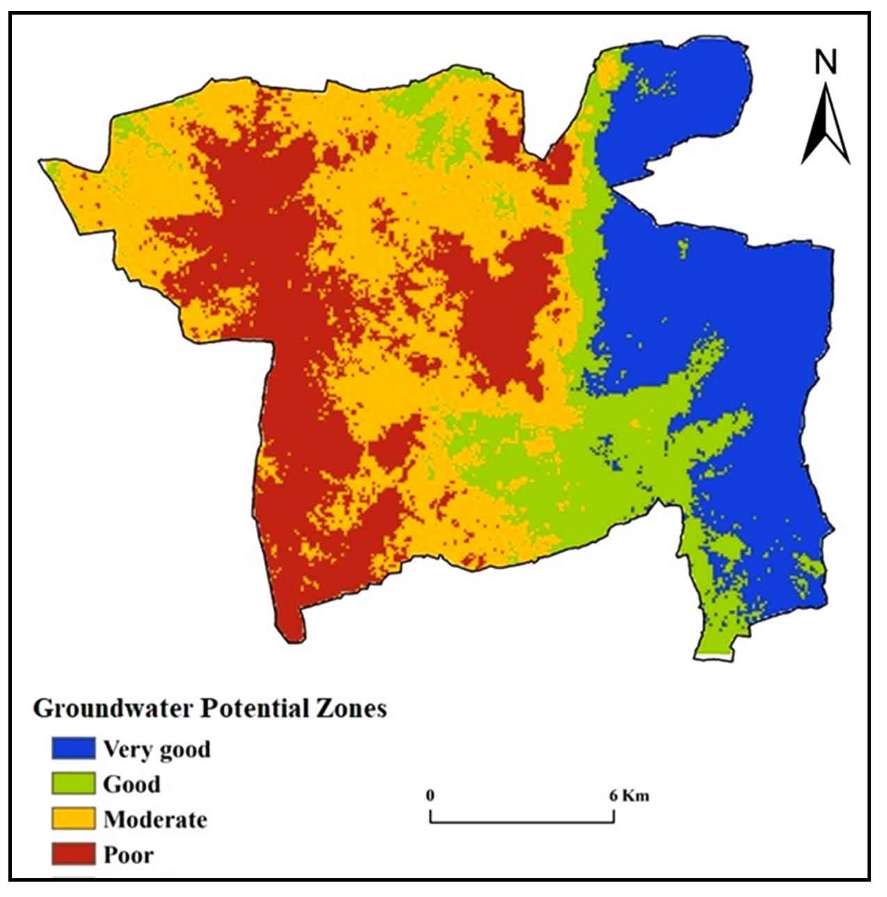
Groundwater potential zones are identified based on eight parameters using GIS-AHP approach groundwater management in the Anantapur district, Andhra Pradesh.
Detailed map of groundwater potential zones is very important for livelihood and socio-economic development.
Potential zones are validate using annual average groundwater level and well discharge values.
RS and GIS techniques are highly effective and useful for identifying GWPZs.
Abrams, W., Ghoneim, E., Shew, R., LaMaskin, T., Al-Bloushi, K., Hussein, S., AbuBakr, M., Al-Mull, E., Al-Awar, M. and El-Baz, F., 2018. Delineation of groundwater potential (GWP) in the northern United Arab Emirates and Oman using geospatial technologies in conjunction with Simple Additive Weight (SAW), Analytical Hierarchy Process (AHP), and Probabilistic Frequency Ratio (PFR) techniques. Journal of Arid Environments, 157, 77-96.
GSI [Geological Survey of India], 2002. District Mineral Resources Map. Anantapur, Andhra Pradesh, India.
Jhariya, D. C., Kumar, T., Dewangan, R., Pal, D. and Dewangan, P. K., 2017. Assessment of groundwater quality index for drinking purpose in the Durg district, Chhattisgarh using Geographical Information System (GIS) and Multi-Criteria Decision Analysis (MCDA) techniques. Journal of the Geological Society of India, 89(4), 453-459.
Kumar, P., Raghu Babu, K., Rajasekhar, M., Narayana Swamy, B. and Ramachandra, M., 2019. Landuse/landcover changes and geo-environmental impacts on beluguppa mandal of Anantapur District of Andhra Pradesh, India using Remote Sensing and GIS Modelling. Research and Reviews: Journal of Space Science and Technology, 8(2), 6-15.
Saaty, T. L., 2000. Fundamentals of decision making and priority theory with the analytic hierarchy process (6). RWS publications.
Shailaja, G., Kadam, A. K., Gupta, G., Umrikar, B. N. and Pawar, N. J., 2019. Integrated geophysical, geospatial and multiple-criteria decision analysis techniques for delineation of groundwater potential zones in a semi-arid hard-rock aquifer in Maharashtra, India. Hydrogeology Journal, 27(2), 639-654.