

Journal of Geographical Studies Volume 9 (2025), Issue 1 · pp. 11-33
Original Research Paper Open Access

Influence of Altitude and Climate on the Distribution of Vegetation, Ecosystem Services and Human Population in Garhwal Himalayan Region
- Department of Geography, Chaudhary Charan Singh University, Meerut, Uttar Pradesh-250001 (India).
- Department of Geography, NREC College Khurja- 203131 (Chaudhary Charan Singh University Meerut) (India).
- Asian Institute of Technology (AIT), PO. Box-4, Klong Luang, Pathumthani- 12120, Thailand.
* Corresponding author: Atul kumar, atulram1990@gmail.com
Contents
- Highlights
- Abstract
- 1. Introduction
- 2. Study Area
- 3. Database And Methodology
-
4. Results And Discussion
- 4.1 Physiography
- 4.2 Climatic Characteristics
- 4.3 Altitude-Wise Spatial Distribution of Vegetation
- 4.3.1Tropical natural vegetation (< 300 m)
- 4.3.2 Sub-tropical natural vegetation (301-800m)
- 4.3.3 Warm temperate natural vegetation (801-1600m)
- 4.3.4 Cool temperate natural vegetation (1601-2400m)
- 4.3.5 Cold temperate natural vegetation (2401-3200m)
- 4.3.6 Sub-alpine natural vegetation (3201-4000m)
- 4.3.7 Snow cover area (> 4000m)
- 4.4 Population Distribution
- 4.4.1 Areas with a low population density
- 4.4.2 Areas with a moderate population density
- 4.4.3 Areas with a high population density
- 4.4.4 Area with a very high population density
- 4.5 Association Between Relative Relief and Population Density
- 5. Conclusion
- Conflict of interest
- Acknowledgements
- Abbreviations
- Article information
- References
-
- Figure 1. Study area: Garhwal Himalayan region, Uttarakhand, India
- Figure 2. Methodological framework
- Figure 3. Association between mean relative relief and population den…
- Figure 4. Geomorphology
- Figure 5. Annual temperature and precipitation
- Figure 6. Forest cover
- Figure 7. Map showing vegetation types of the Garhwal Himalayan region
- Figure 8. Agro-forest-livestock based livelihood system
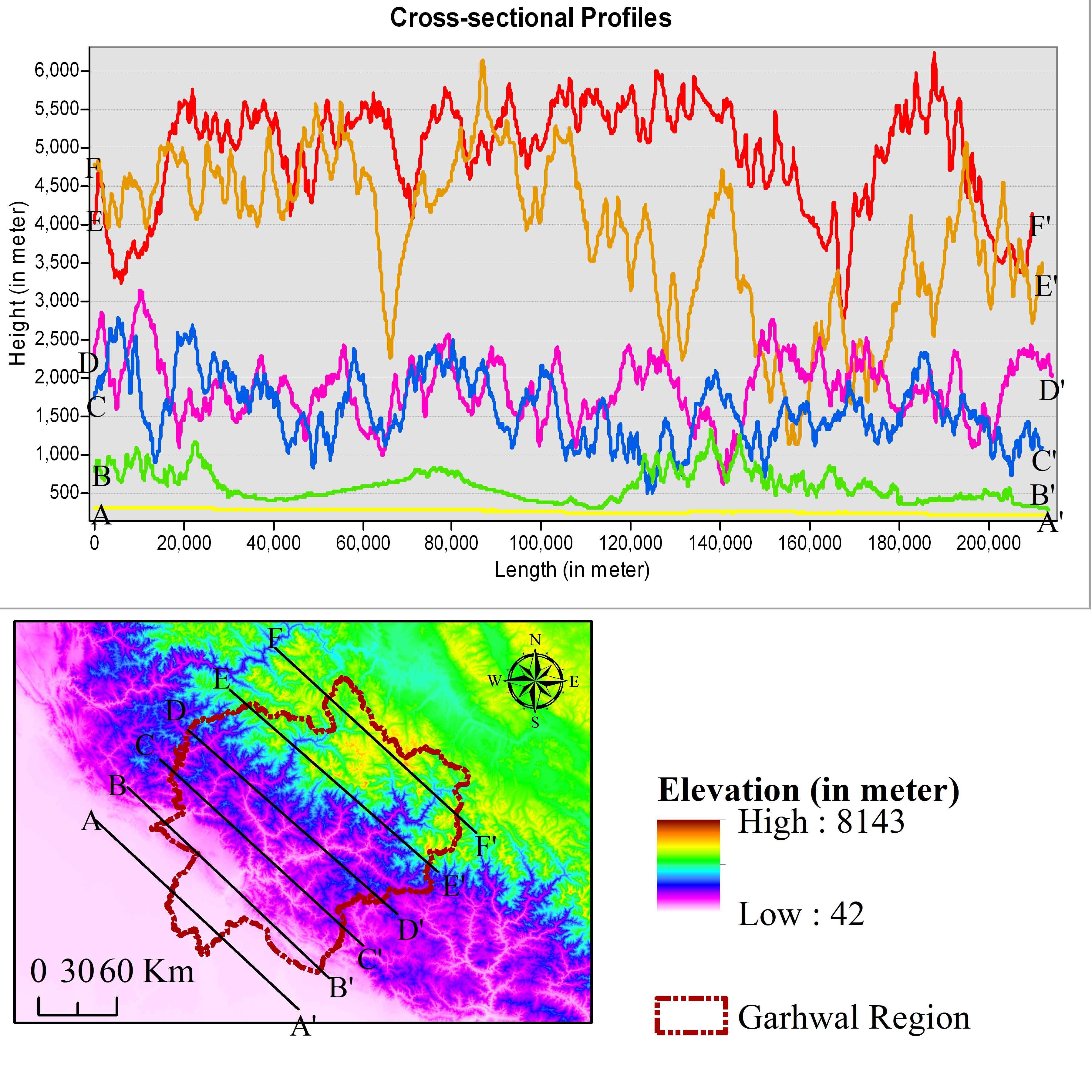
- Figure 9. Cross-sectional profiles
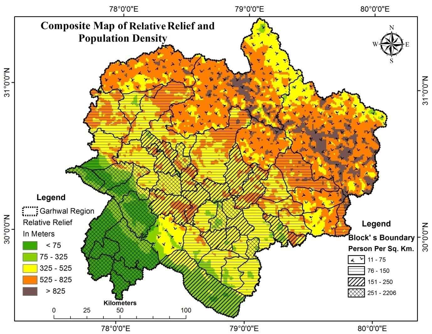
- Figure 10. Composite map of relative relief and population density
-
- Table 1. Population characteristics
- Table 2. Classification of surface according to Z-score value
- Table 3. Annual temperature and precipitation pattern
- Table 4. Altitude-wise area under vegetation
- Table 5. Block-wise Population distribution
- Table 6. Relative relief and population density
- Table 7. Distribution of population
- Table 8. Major plant species useful for fuel and fodder
Highlights
- Distribution of vegetation with altitude in the Himalayan region assessed using remote sensing and geospatial techniques.
- In the Garhwal region, 14.44% population with high-dense category residing along the River valleys.
- The negative association was observed between population density and relative relief.
- In high altitude regions (>2000m) with available pastures, over 30% population depends on NTFPs gathering and earnings.
- Relative relief and climate influence on livestock husbandry and non-timber forest products (NTFPs) in the Himalayan region.

Abstract
Altitude plays a crucial role in determining habitat distribution, species diversity, and ecological resources, which support livelihoods and employment in the Himalayan region. Covering 18% of India's territory, the Himalayas house over 50% of the country's forest cover and 40% of the Indian subcontinent's endemic species, providing ecosystem services to 115 million people. However, the relationships between elevation, ecological services, and population resource dependency are poorly understood. This study examines the spatial linkages between elevation, climate, and ecosystem distribution, as well as the relationship between ecosystem services and population density using livelihood indicators. Spatial analysis reveals an inverse relationship between population density and relative relief (-0.69; P<0.05). Population density is concentrated (14.44%) along the fertile Alaknanda and Bhagirathi River valleys (900–2200m), which cover 14.95% of the area. Conversely, 5.33% of the population is scattered across 41% of the region, with higher elevations (>2000m) relying on non-timber forest products (NTFPs) for over 30% of income. These findings highlight critical patterns in population distribution, resource dependency, and ecosystem services, offering valuable insights for policymakers to promote biodiversity conservation, equitable resource sharing, and sustainable development in the Himalayan region.
Keywords Geospatial techniqueRemote Sensingrelative reliefpopulation distributionHimalayan livelihood Garhwal Himalayas
1. Introduction
In the Himalayan region, India occupies a special place in the world’s mountain ecosystems. These geo-dynamically young mountains are important from climate and life, providing water to many parts of the Indian subcontinent and containing a rich diversity of flora, fauna, people, and cultural diversity (Singh, 2006). The Himalayan mountain system only covers 18% of India's territory but accounts for over 50% of India's forest covers and 40% of the Indian subcontinent's endemic species (Singh, 2006). Himalayan resources and ecosystem services are important for 115 million mountain people and a much larger population living in neighboring Indo-Gangetic plains (Rao et al., 2003). Around 64 percent of the total geographical area of the Garhwal Himalayan region is forested (FSI, 2003). The state is experiencing an economic transformation, and the exploitation of natural resources has reached an unprecedented level because of population growth and increased demand for different products (Pramanik, 2016).
The mountain's notable vegetation zone depends on the altitude and the climate (Malik et al., 2014). Altitude and the slope aspect play an essential role in determining an area's weather conditions. The physiographical factors impact plant microhabitats, especially on the hillside (Sharma et al., 2009). The cofactors incorporating topography, slope and slope aspect, land use and land cover (LULC), and soil type affect the forest composition based on altitude (Mondal et al., 2017; 2020). Ellu and Obua (2005) have stated that different altitudes and slopes affect the dispersal activity and abundance of tree species. In addition, the wide range of elevations has also become a factor of climatic variations with topography. The result was a heterogeneous landscape with rich habitat and species diversity and species endemism, especially in the mountainous regions (Kharkwal et al., 2005). The ecological variation associated with an elevation range and the species richness decreases with increasing elevation in the Garhwal regions in the same way as its general decrease with increasing latitude (Singh, 2006).
Various drivers of change, including human activities such as timber harvesting, intensive livestock pasture and agricultural production into forestry, threaten the sustainability of mountain habitats and sustained biodiversity (Sandhu and Sandhu, 2015). The Garhwal Himalayan area has already experienced modernization problems, such as air pollution, GHG emissions, land use transformation, fragmentation, land degradation, and deforestation. The region is also affected by rapid environmental and socioeconomic changes, which subsequently affected landscapes and communities (Biswas et al., 2015; Singh, 2006).
For the planning and policymaking of environmental protection and sustainable development of mountain regions as well as downstream areas, identity, and awareness of important ecological and socio-economic parameters of mountain ecosystems, including climate susceptibility, have become essential aspects (Singh, 2006). The composition, structure and density of different Himalayan forests changes due to the variation in climate, unregulated felling and lopping of fuel wood, grazing, and fodder (Kumar et al., 2004; Chakraborty et al., 2018; Kuniyal et al., 2024). Anthropogenic pressures cause significant alterations in forest structure and density, leading to biodiversity loss. Consequently, forest regeneration through afforestation and controlled grazing can play a crucial role in accelerating recovery. This highlights the importance of adopting sustainable land-use practices to mitigate further degradation (Pandey and Singh, 1985).
The topographical relief is an important index for classifying geomorphic forms (Asthana et al., 1991). The relationship between tectonics and the surface denudation mechanism is responsible for the characteristics of regional topographic relief. The topographic analysis is another important research component into the geomorphologic and earth surface phase as an effective research tool in active tectonics and neo-tectonics (Zhang et al., 2006). In recent years, the production and enhancement of RS, GIS, and other spatial analytic techniques have provided comfortable and rapid technological support for analyzing regional topographical relief. The topographical relief and swath profile method based on DEM can get topographical relief characteristics of the area, which could explain objectively and quantitatively the changes in the elevational attributes of the region's terrestrial forms (Kumar et al., 2021; Asthana et al., 1991; Kan et al., 2006; Pramanik, 2016). The human settlement plays an important role in the connection between people and earth and represents the relationship between people and the world in which they live (Fragkias and Seto, 2009).
In the Garhwal Himalayan region, particularly from Civil Soyam Panchayat forest and reserved forest are the major source of different ecosystem services, particularly fodder and fuelwood, which is mainly extracted from neighbouring forest fringe areas by lopping the vegetative biomass of shrubs, herbs, grasses, and trees (Singh, 1999; Singh et al., 2010). Forest-based fodder plays an important role in traditional farming, livestock production, tourism and animal husbandry (Chaudhary et al., 2022; Dhyani et al., 2011). The key source of leaf litter (used for livestock mainly) and fodder for most households/communities is the nearby public forests. It is common throughout the Himalayas and particularly valuable in the dry winter season when fodder quantities and quality from other sources are limited. Various research has been carried out daily per household fodder consumption in the Himalayan region and revealed altitudinal variations of fodder consumption pattern (Partap, 2011; Sati and Singh, 2010; Singh et al., 2017). Average fodder consumption per household found 39.14 ±30.06 kg in the Himalayan region (Dhanai et al., 2014). There are various fodder plant and tree species which are generally used for livestock fodder consumption.
Diverse forest resources are among the most valuable natural resources that play an important role in the growth of any country's society, culture, history, economy, and industry and preserve its ecological balance (Singh, 2006; Sharma et al., 2009). In addition, land under agricultural practices in such a hilly region also supports a prime resource for carrying out their livelihood activities but is immensely interlinked with forest resources. Both lands under forest and agriculture support the population and biodiversity of the region (Chaudhary et al., 2019). Although the vegetation characteristics and density of the human population along elevation gradients are not quantitatively well documented. There was a research question that enquired about the association land and human population, how the human population depends upon the forest resource, and how the forest-based ecosystem services play a vital role in the livelihood economy of the people of this region. In addition to this, the study assesses the impact of climate and geomorphic association with the human population. The spatial analysis approach was combined with the geoscience research method to quantitatively analyze the relationship between land under vegetation and population density with elevation in the Garhwal Himalayan region. Combining population density and vegetation characteristics with elevation makes it possible to derive the forest-dependent population density within a specific elevation range and geographic zone. This will estimate the vegetation characteristics and population distribution in the Garhwal region, an important parameter to estimate forest-dependent livelihood dependency and resource management.
Along with food, forest-based ecosystem services are also essential for sustaining economic sources of livelihood in this region. It helps to analyze the factors influencing population distribution and suggests that the population distribution in the Garhwal Himalayan Mountains be optimized. Understanding this spatial variation will provide useful insight for policymakers and planners. Despite considerable research on Himalayan landscape diversity, vegetation distribution, ecosystem services, and human habitation in the Garhwal Himalayas, multi-disciplinary, integrating topographic variability, climatic changes, vegetation, human adaptation, and policy perspectives remain limited. The findings of this study will also provide significant information and theoretical guidance for the distribution of population and ecological conservation in the region of the Garhwal Himalaya.
2. Study Area
For this study, the Garhwal region, a mountainous terrain, has been selected to analyze the terrain characteristics, vegetation distribution, climatic attributes and human population distribution. The Garhwal Himalaya is situated between 30°N to 31°N latitude and 70°E to 78°E longitude (Figure 1). This region, known for its breathtaking landscapes and well-preserved natural beauty, lies in northern India. To the East, it is bordered by the districts of Nainital and Pithoragarh, which separate it from Kumaon, while the Tons River forms its western boundary with Himachal Pradesh. Stretching from the foothills in the South to the snow-clad peaks along the Indo-Tibetan border in the North, the region showcases diverse topographical and ecological variations. The Garhwal Himalaya constitutes 60.67% of Uttarakhand’s total geographical area (Table 1). Uttarakhand, the 27th state of India, is administratively divided into two divisions: Garhwal and Kumaon. The Garhwal Division comprises seven districts: Uttarkashi, Chamoli, Rudraprayag, Tehri Garhwal, Pauri Garhwal, Dehradun, and Haridwar district. It is further subdivided into 30 tehsils, 382 Nyaya Panchayats, 54 development blocks, 8,658 villages, and 55 urban centers (Census of India, 2011).
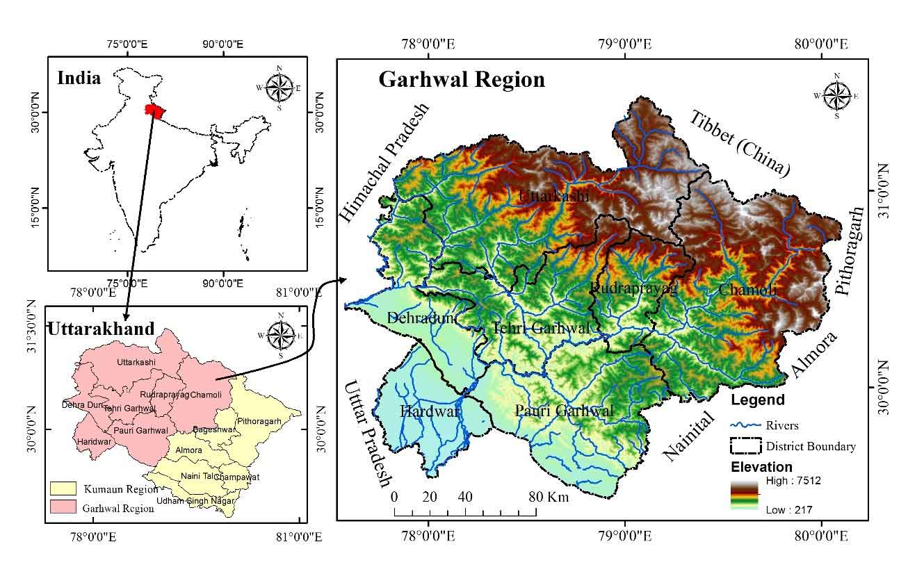
The topographical form of Garhwal Himalaya has varied characteristics. The Garhwal Himalaya is like a storehouse of landscape topology. The study area has many landscapes, i.e. glacial, periglacial, glacio-fluvial, fluvial, high valley, narrow plains, foothills, low mountains, and plains regions. Relief in the Himalayas varies from low valleys and narrow strips to very high mountainous areas. The mountain system of Garhwal Himalaya has a North–West and South–Easterly direction, and it can be regarded as a series of spurs from the Tibetan water shade. The whole region consists of a succession of steep mountain ridges divided from each other by deep glens. It is important to note that the effect of elevation may be profoundly modified by geology and soils. The region's geological history reveals rocks of different character and different geological ages, ranging from the Archaean era to recent times (Kharakwal, 1993).
Table 1. Population characteristics
|
Garhwal |
Population |
Male |
Female |
Density (Person/km2) |
|
2001 |
4923966 |
51.28 |
48.72 |
152 |
|
2011 |
5857294 |
51.00 |
49.00 |
181 |
Three significant partitions separate the entire region of Garhwal Himalaya by thrust and faults as Main Central Trust (MCT), Main Boundary Thrust (MBT), and Himalayan Frontal Fault (HFF). MCT is working as a divider between Greater Himalaya and Lesser Himalaya. MBT is working as a divider between Lesser Himalaya and Shiwalik Himalaya (Valdiya, 1988). As like HFF is separate Shiwalik Himalaya from Piedmont in the southern part of the Garhwal region. With the 50km of wideness, the Greater Himalayan region has to mean relief between 4,800m and 6,000m. The central part of the Himalayas knows as the Lesser Himalayan region. It is like a sandwich between Greater Himalaya and Shiwalik Himalaya North and South, respectively, with the 75km width the Lesser Himalaya having the relief of ridges in between 1500m to 2700m and valleys between 500m and 1200m. The relief degree of the land surface (RDLS) is a synthetic representation of the elevation and steepness of a region (Hui et al., 2015).
3. Database And Methodology
3.1 Data
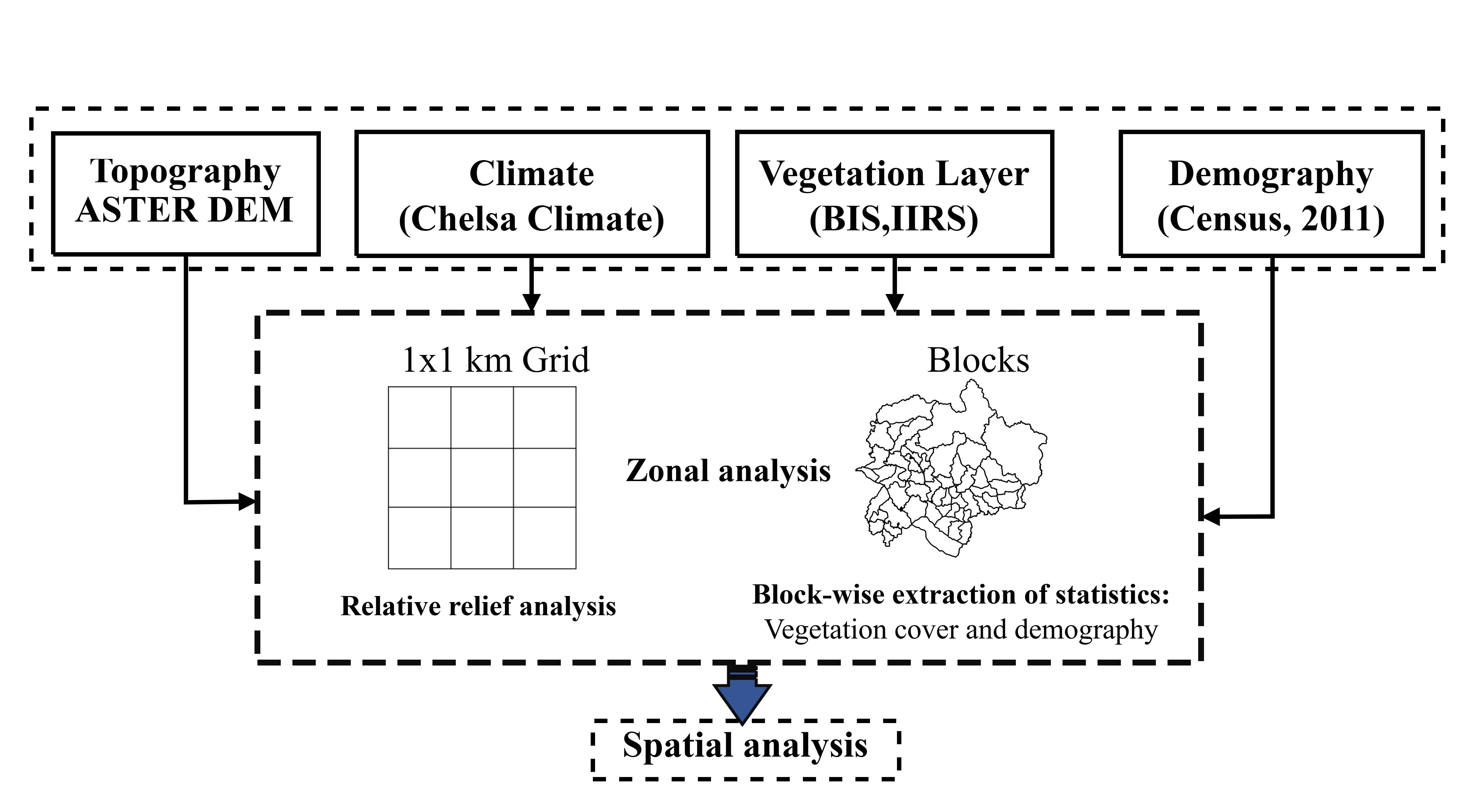
This study is based on the various remote sensing topographic, thematic and geospatial data sources. For the population-related descriptions, census data of 2011 and 2001 are used, which was collected from the census of India (2011). Based on a 30m resolution, the Advanced Spaceborne Thermal Emission and Reflection Radiometer (ASTER) DEM was used to attain relative relief value in the study area, downloaded from the United States Geological Survey (USGS) earth explorer (http://earthexplorer.usgs.gov/). For the present study, a grid was generated by the fishnet tool in Arc-GIS 10.4 with a pixel size of 1 km2 (Figure 2). The block boundary of the Garhwal Himalaya region is used in the study obtained from the statistical department. The vegetation type’s data was extracted from the Biodiversity Information System (BIS, IIRS) (https://bis.iirs.gov.in/). Block-wise minimum, maximum temperature and precipitation were analyzed using high-resolution climatology at high resolution CHELSA data, collected from https://chelsa-climate.org/. In addition to it, to map the various geomorphic characteristics of the region, geomorphological thematic GIS layer was obtained from (BHUKOSH, Geological Survey of India) https://bhukosh.gsi.gov.in/.
3.2 Methods
In the present study, to arrive at the comparison between population distribution and relative topographic relief of the area's land surface. According to the Census of India (2011), the block-wise population density was analyzed spatially and statistically with Arc-GIS. Later on, extract relative relief of land surface 1 km grid used with Advanced Space-borne Thermal Emission and Reflection Radiometer (ASTER) Digital Elevation Model (DEM). Topographic relative relief of land surface is also called local relief indefinite land unit the relief characteristics represented by using two methods, e.g., relative relief method and swath profile method. In the first method, the relative relief of land surface (RRLS) was extracted by using maximum height (m) and minimum height (m). Within the window (1 x 1) and endows them to each window to get two data layers and subtracts the maximum height from the minimum height to get the height relative relief of each grid (Zhiming et al., 2008). To eliminate the subjectivity in determining the uniform of physiographic zone classification, the 'Z' score standardized method has been adopted (Asthana et al., 1991).
To analyze the statistically block-wise, population density and mean relative relief were correlated, and spatially relative relief map and population density map were composed.
\(RRLS={[Max(H)-Min(H) ] \over A}\) (1)
where, RRLS represent relative relief of land surface, Max(H) and Min(H) represent the highest and lowest altitudes of the region, respectively. In this study, we have chosen a 1 km × 1 km grid as the fundamental unit for zonal analysis, resulting in A = 1km² (Figure 2). To classify the relief characteristics, Z score using the following equation 2.
\(Z= { x-μ \over σ}\) (2)
Where, Z = z-score, X = individual data point, μ (mu) = mean of the dataset, σ (sigma) = standard deviation of the dataset. The Z-score represents how many standard deviations a data point is from the mean. A positive z-score indicates that the value is above the mean, while a negative z-score indicates that the value is below the mean.
Subsequently, the Z-score range was categorized into five distinct classes: < -1.5, -1.5 to -0.5, -0.5 to 0.5, 0.5 to 1.5, and > 1.5. The Z-score represents the number of standard deviations a value deviates from the mean, serving as a basis for classifying regional relief. This classification facilitates zoning by integrating topographic similarities within the study area.
To associate vegetation, land-use, and population characteristics in different altitudinal zones were analyzed at block-level using zonal analysis in Arc-GIS software. In addition to this, climatic characteristics (annual mean precipitation and maximum and minimum temperature) were incorporated to demonstrate their impact on the regional environment. The stepwise procedure methodological framework is shown in figure 2. The second swath profile method indicates the digital topographic map width by calculating the band range, then generates several parallel profile lines intersected with the contours in the band zone, defined by Fielding (1994). The elevation values were determined according to the sample spacing perpendicular to the direction of the profile axis. Six curves quantitatively define the topographical relief characteristics of the band zone in the topographical profile maps.
4. Results And Discussion
4.1 Physiography
The Garhwal Himalayan region is the most dissected terrain characteristics compared to the other parts of northern India. It is due to the proximity and existence of numerous faults and thrusts. Some majors are MCT, MBT and HFF, which separates it into the four major physiographic zones: the Greater Himalayan range, the Lesser Himalayan range, the Shiwalik Himalayan range, and Ganges Great plains (Valdia, 1979; Valdiya, 1988; Mandal et al., 2023). The Garhwal region's absolute relief ranges from 145m to 7799m, shown in the figure 1. The relative relief indicates the regional/local relief range is classified by applying the ‘Z’ score standardised method into five relative relief categories shown in figure 8 (Table 2). The maximum area falls in the two major categories moderately high relief surface (40.49%), high relief, and steep slope surface (37.49%), whereas plain surface occupies 9.31%. Low relief surface 8.47 % area of the region, only 4.25% area remains in the very high relief surface in upper ridges of Greater Himalayan ranges (Figure 3).
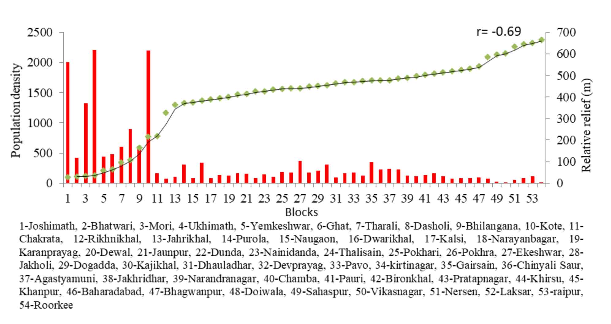
Table 2. Classification of surface according to Z-score value
|
Z-score value |
Relative relief range |
Surface characterizes |
Area (%) |
|
<-1.5 |
< 75 |
Plain surface |
09.31 |
|
-1.51 – -0.50 |
75 – 325 |
Low relief surface |
08.47 |
|
-0.5 – 0.5 |
325 – 525 |
Moderately high relief surface |
40.49 |
|
0.5 – 1.5 |
525 - 825 |
High relief and steep slope surface |
37.49 |
|
>1.5 |
> 825 |
Very high relief surface in upper ridges |
04.25 |
The zonal topographic characteristics indicate distinctive features developed due to various morphogenetic processes and structural progressions, i.e., glacial, fluvial, denudation, structural, and anthropogenic activities. According to the geomorphological map, different mophogenic processes result from the enormous variance in topography resulting in diverse climatic conditions, i.e. glacial, denudational, structural, fluvial (Figure 4). The northernmost part is influenced by glacial processes, where a significant part is perennially covered with scow in glaciers. The lower parts are largely glacio-fluvial processes, and most of the area is permafrost. There are various types of landforms, i.e., glacial terrain originated from glacial, cirque, arete, nunatak, kame terrace, hanging valley, lateral moraine and medial moraine found due to glacial processes (Figure 4). In the valley region in the upper part of the greater and lesser Himalayan ranges, denudational landforms (erosional and depositional) formed due to slope instability and rock formations are mass wasting products, piedmont slope and landslides found on various sites displayed in figure 4. In the Greater, Lesser, and Shiwalik Himalayan ranges in the region, maximum space is occupied by structural landform in the form of highly dissected hills and valleys, low dissected hills and valleys, moderately dissected hills and valleys, hills, ridge, intermontane valley, strike ridge and strike valley that is demonstrated in the map (Figure 4). In this whole region, moderately and less dissected valleys are the most habitable site for humans and their livelihood development. The fluvial process is most dominant in this sub-tropical monsoon climatic region; the Ganga, Yamuna and Ramganga rivers flowing in this region perennially develops a wide range of landforms (strath terrace, active flood plain, older flood plain, younger alluvial plain, older alluvial plain, piedmont alluvial plain, alluvial fan, point bar, braided bar, channel bar, lateral bar, channel sand, colluvial fan and dissected alluvial fan, crevasse splay, marsh, meander scar and oxbow lake) in their young, mature and old stage of landscape development (Figure 4). Besides natural processes, there are various landscapes, i.e., hill terraces, abandoned quarry, active quarry due to anthropogenic interventions and the moderate to nearly plain slope across the region.
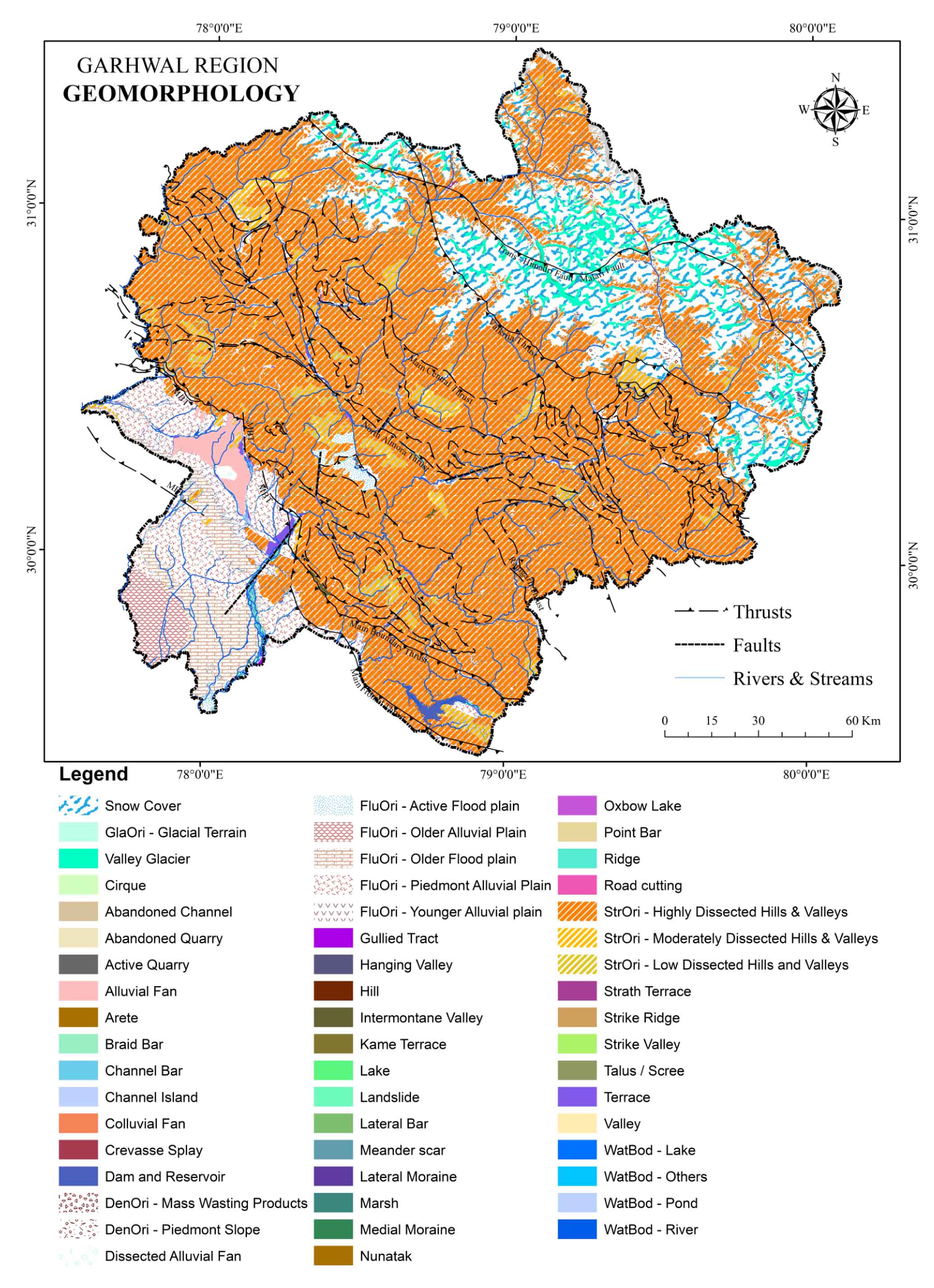
The Garhwal Himalaya is characterized by a complex network of thrusts and faults, which not only define its geological framework but also exert a significant influence on river courses. These tectonic features distinctly separate the Trans-Himalaya, Greater Himalaya, Lesser Himalaya, and Shiwalik Himalaya, running from north to south.
The Mandhani Thrust demarcates the boundary between the Greater Himalaya and the Trans-Himalaya (Tethys Himalaya), which lies in the uppermost part of the region. The Main Central Thrust (MCT), a major geological feature nearly parallel to the Himalayan terrain, marks the transition between the Lesser Himalaya and the Central Crystalline zone (Figure 4). First identified by Heim and Gansser (1939) in the Kali Valley, this thrust was later redefined by Valdiya (1979), who termed it the Munsiari Thrust. Valdiya also discovered an additional thrust located a few kilometers north of the MCT, which transported high-grade metamorphic rocks to the Vaikrita Thrust in the Higher Himalayan region.
The MCT passes through several key locations, including Arakot, Naitwar, Bhatwari, Guttu, Ukhimath, Chopta, Helang, Karamnasa, Patal Ganga, Dhak, Tharali, and Loharkhet, Narayan Bagar. Reactivation of this thrust has triggered numerous landslides, notably in Karamnasa, Badeth, Kunjapuri, Sainj, Nald, Uttron, Mori, and Arakot. Further south, the Main Boundary Thrust (MBT) represents a major tectonic boundary, separating the Outer (Shiwalik) Himalaya from the Lesser Himalaya. Along this thrust plane, the older Lesser Himalayan sequences override the younger Tertiary formations. Although the MBT extends continuously for approximately 2400 km along the length of the Himalaya, additional crystalline thrusts-such as those in Almora, Bhatwari, Lansdowne, Satengal, Banali, and Purola-further contribute to the complex tectonic setting. Notable thrusts in the region include the North Almora Thrust, South Almora Thrust, Bhatwari Thrust, Amri Thrust, and Ramgarh Thrust (Valdiya, 1979).
Apart from these thrusts, tear faults, trending NNE-SSW, disrupt the continuity of the MBT at several locations, including Kalsi, Yamuna Tear, Song, Kesharwala, and Ganga Tear between Haridwar and Laxmanjhula. These faults influence the course of several smaller rivers, such as the Western Nayar, Mehdigad, and Jalkur (Figure 4). The Shiwalik Hills in the Garhwal region, located between the MBT and the Main Frontal Thrust (MFT), extend in a northeast-southwest direction (Figure 4). The Ganga River, flowing north to south, cuts across this range in the central part of the region.
Recent research by Mandal et al. (2023) explores the structural segmentation of the Uttarakhand Himalaya and its implications for earthquake hazards. Their analysis of seismic data identifies distinct structural segments within the region, which play a crucial role in determining the distribution and magnitude of seismic activity. Their findings underscore the importance of structural variations in earthquake occurrence, emphasizing the need for region-specific seismic hazard assessments and mitigation strategies in the Uttarakhand Himalaya.
4.2 Climatic Characteristics
The Garhwal Himalayan region experiences three distinct climatic seasons: a warm summer from March to June, a humid and warm monsoon season from July to October, and a cold winter from November to February. This region is increasingly subjected to extreme weather events due to erratic precipitation patterns during the monsoon, making it highly susceptible to natural disasters such as cloudbursts, landslides, avalanches, and floods, particularly in the piedmont plains (Bhutiyani et al., 2009; Pal et al., 2016a, b). A common climatic phenomenon in this region is the decline in temperature with increasing elevation, influencing both spatial and temporal climatic patterns.
The Garhwal Himalaya exhibits a diverse climatic gradient, ranging from tropical conditions in the lowlands to glacial environments in the high-altitude zones. Based on elevation, seven distinct climatic zones have been identified from south to north: tropical (<300m), subtropical (301–800m), warm temperate (801–1600m), cool temperate (1601–2400m), cold temperate (2401–3200m), sub-alpine (3201–4000m), and glacial (>4000 m) (Kharkwal, 1993). Temperature and precipitation vary significantly across these altitudinal zones (Figure 5). The maximum recorded temperature across these zones is >39.9°C in tropical areas, 36.1°C in subtropical zones, 30.1°C in warm temperate regions, 24.1°C in cool temperate areas, 18.1°C in cold temperate zones, 9.1°C in sub-alpine regions, and <5°C in glacial zones. Minimum temperatures follow a similar pattern, ranging from 6.1°C in tropical areas to as low as -11.6°C in glacial regions.
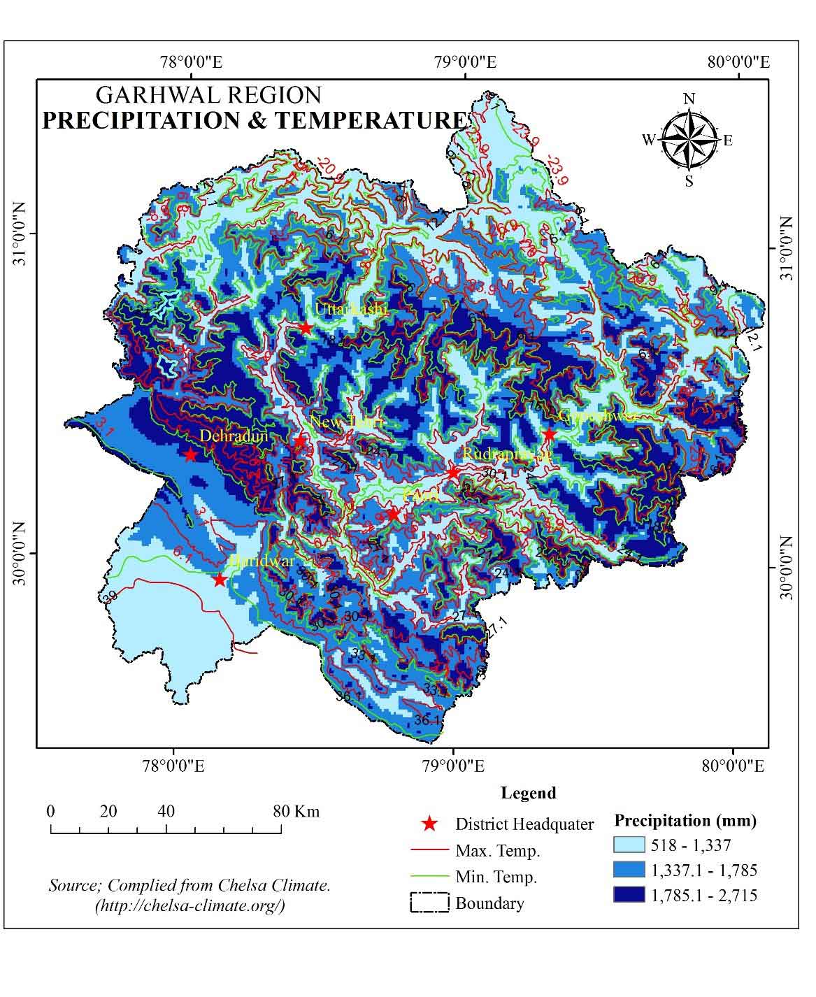
Precipitation levels also vary with altitude, with annual precipitation exceeding 2500mm in the glacial zone, primarily in the form of snowfall and hailstorms. Other zones receive varying levels of precipitation: 2500–2700 mm in the sub-tropical zone, 2000–2500 mm in warm temperate areas, 1800–2000 mm in cool temperate regions, 1600–1800 mm in cold temperate areas, 1200–1600 mm in sub-alpine regions, and less than 900 mm in the lowest-lying tropical areas (Table 3). Numerous studies have explored climatic variations and their impact on both biotic and abiotic resources, emphasizing the importance of altitude-based climatic classification in understanding regional climatic patterns (Kaushik, 1962). The region experiencing climate change scenario is evident from the study that revealed climate change scenarios of the last 4000 years and found a significant impact on vegetation in different altitudes (Quamar et al, 2023; Demske et al., 2016; Bhattacharyya et al., 2011). The regional ecosystem is susceptible; therefore, it is suffering from drastic climate change due to various natural and anthropogenic factors resulting from cloudbursts, avalanches, glacial retreat, monsoon onset, and erratic rainfall patterns, drought, etc.
Table 3. Annual temperature and precipitation pattern
|
Climatic zones |
Altitude (m) |
Minimum temp. (°C) |
Maximum temp. (°C) |
Precipitation (mm) |
|
Tropical |
< 300 |
< 6.6 |
> 39.9 |
< 900 |
|
Sub-tropical |
301-800 |
3.1 |
36.1 |
900-1200 |
|
Warm temperate |
801-1600 |
0.1 |
30.1 |
1200-1600 |
|
Cool temperate |
1601-2400 |
-2.9 |
24.1 |
1600-1800 |
|
Cold temperate |
2401-3200 |
-8.9 |
18.1 |
1800-2000 |
|
Sub-alpine |
3201-4000 |
-11.6 |
9.1 |
2000-2500 |
|
Glacial cover |
> 4000 |
> -20.9 |
<5 |
> 2500 |
4.3 Altitude-Wise Spatial Distribution of Vegetation
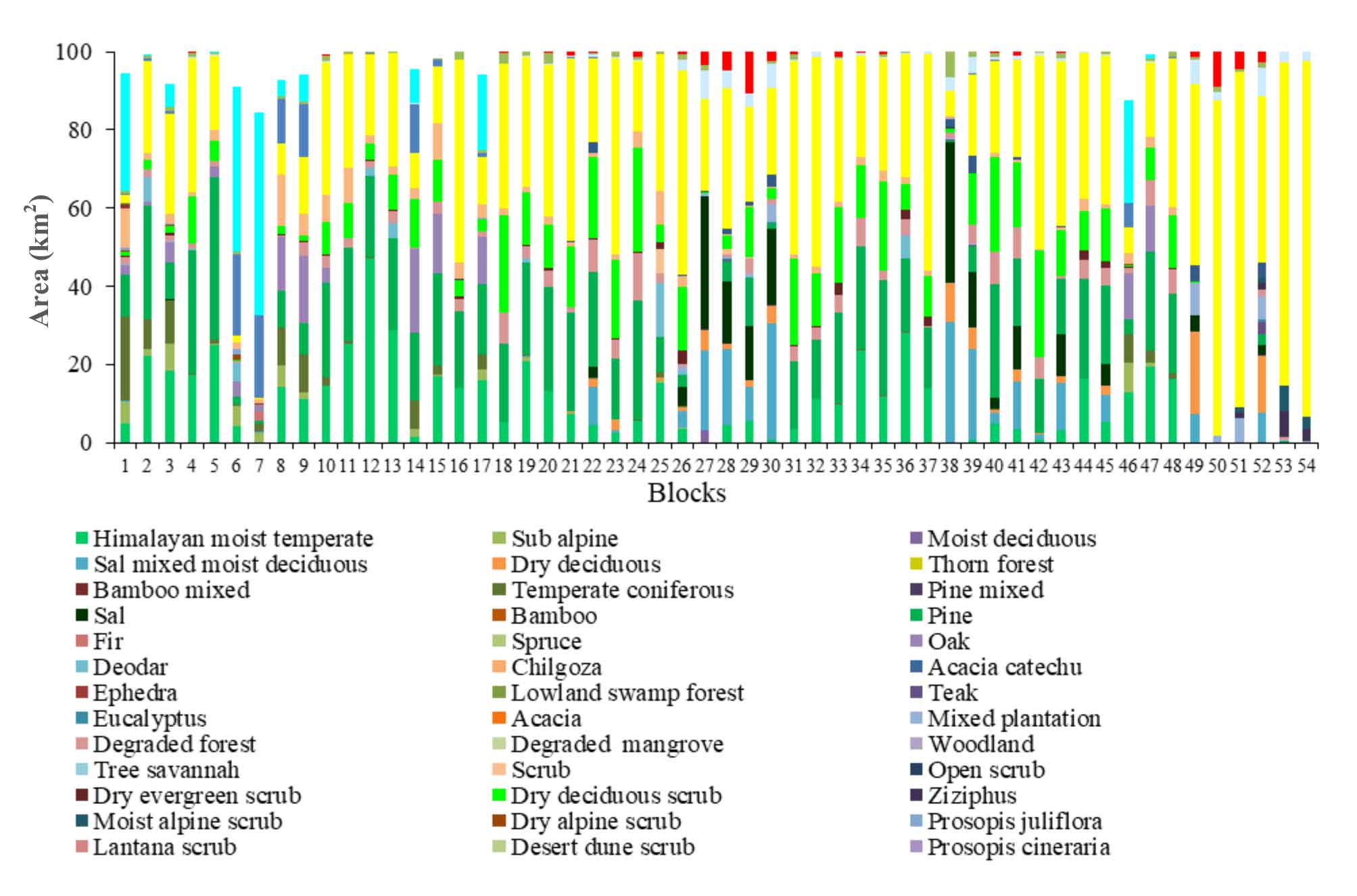
Table 4 presents the diverse forest types found across the Garhwal Himalayan region, classified according to altitudinal zones ranging from less than 300m to greater than 4000m. The region is broadly categorized into five major vegetation classes, with forests covering the most extensive area, approximately 19683.47km² (60.59%) of the total landscape. Apart from forest cover, agriculture and rural settlements collectively account for 6462.60 km² (19.89%), while snow-covered areas, water bodies, and major settlements occupy 5,513.90km² (16.97%), 622.15km² (1.92%) and 204.18km² (0.63%), respectively. A total of 59 distinct forest species have been identified in the region, which have been broadly reclassified into 22 major forest sub-classes. Am (Table 4). Long these, pine forests dominate, covering approximately 3,359.56 km² (10.34%). Other significant forest types include Himalayan moist temperate forests (2600.93 km², 8.01%), dry deciduous scrub (1757.32 km², 5.41%), alpine pastures (1666.24 km², 5.13%), sal mixed moist deciduous forests (1,225.23 km², 3.77%), sal forests (1074.82 km², 3.31%), grasslands (1,030.02 km², 3.17%), oak forests (1009.09 km², 3.11%), temperate coniferous forests (944.96 km², 2.91%), sub-alpine forests (682.69 km², 2.10%), degraded forests (660.54 km², 2.03%), dry deciduous forests (514.16 km², 1.58%), and deodar forests (379.89 km², 1.17%) (Figure 6). The distribution of forest types across different altitudinal zones, forming major forest groups, is discussed in detail in the subsequent sections (Table 4).
Table 4. Altitude-wise area under vegetation
|
Altitude (m) Vegetation Zones |
Area (%) |
|||||||
|
< 300 |
301-800 |
801-1600 |
1601-2400 |
2401-3200 |
3201-4000 |
> 4000 |
Total |
|
|
Agriculture and Rural Settlement |
20.11 |
11.36 |
43.01 |
23.87 |
1.56 |
0.08 |
0.01 |
19.89 |
|
Alpine pasture |
0.00 |
0.00 |
0.76 |
4.45 |
11.32 |
43.76 |
39.72 |
5.13 |
|
Alpine scrub |
0.00 |
0.00 |
0.00 |
0.00 |
7.98 |
65.65 |
26.38 |
0.25 |
|
Barren land |
0.01 |
0.15 |
0.31 |
0.29 |
2.28 |
18.39 |
78.57 |
6.57 |
|
Degraded forest |
2.09 |
10.25 |
39.71 |
34.33 |
11.25 |
2.32 |
0.06 |
2.03 |
|
Deodar |
0.00 |
0.00 |
3.25 |
27.35 |
48.98 |
19.88 |
0.54 |
1.17 |
|
Dry deciduous |
4.22 |
76.89 |
16.79 |
1.71 |
0.39 |
0.00 |
0.00 |
1.58 |
|
Dry deciduous scrub |
0.15 |
9.04 |
65.57 |
23.10 |
1.94 |
0.20 |
0.00 |
5.41 |
|
Dry evergreen scrub |
0.00 |
0.05 |
37.44 |
42.40 |
11.45 |
8.03 |
0.63 |
0.31 |
|
Fir |
0.00 |
0.00 |
0.01 |
9.65 |
53.24 |
33.77 |
3.33 |
0.33 |
|
Grassland |
0.73 |
12.67 |
22.95 |
46.89 |
15.80 |
0.96 |
0.00 |
3.17 |
|
Himalayan moist temperate |
0.03 |
0.46 |
9.03 |
69.15 |
21.14 |
0.19 |
0.00 |
8.01 |
|
Mixed plantation |
53.52 |
34.87 |
1.02 |
0.15 |
2.68 |
7.04 |
0.72 |
0.80 |
|
Oak |
0.00 |
0.00 |
0.19 |
8.70 |
78.64 |
12.27 |
0.19 |
3.11 |
|
Pine |
0.59 |
3.50 |
37.96 |
50.93 |
6.43 |
0.58 |
0.00 |
10.34 |
|
Pine mixed |
0.00 |
78.38 |
21.62 |
0.00 |
0.00 |
0.00 |
0.00 |
0.01 |
|
Sal |
0.10 |
81.15 |
17.41 |
0.45 |
0.17 |
0.69 |
0.03 |
3.31 |
|
Sal mixed moist deciduous |
1.26 |
76.49 |
19.90 |
0.80 |
0.21 |
1.10 |
0.24 |
3.77 |
|
Scrub |
0.00 |
8.16 |
63.49 |
25.48 |
2.72 |
0.14 |
0.01 |
0.19 |
|
Settlement |
38.64 |
52.24 |
4.39 |
4.20 |
0.30 |
0.23 |
0.00 |
0.63 |
|
Snow Cover |
0.00 |
0.00 |
0.00 |
0.02 |
0.42 |
4.83 |
94.72 |
16.97 |
|
Sub alpine |
0.00 |
0.27 |
3.20 |
9.93 |
32.87 |
49.99 |
3.75 |
2.10 |
|
Teak mixed moist deciduous |
41.07 |
58.25 |
0.13 |
0.03 |
0.18 |
0.29 |
0.05 |
0.09 |
|
Temperate coniferous |
0.00 |
0.10 |
1.97 |
20.29 |
60.87 |
16.60 |
0.17 |
2.91 |
|
Water body |
17.60 |
60.03 |
16.04 |
2.74 |
2.00 |
1.34 |
0.24 |
1.92 |
4.3.1Tropical natural vegetation (< 300 m)
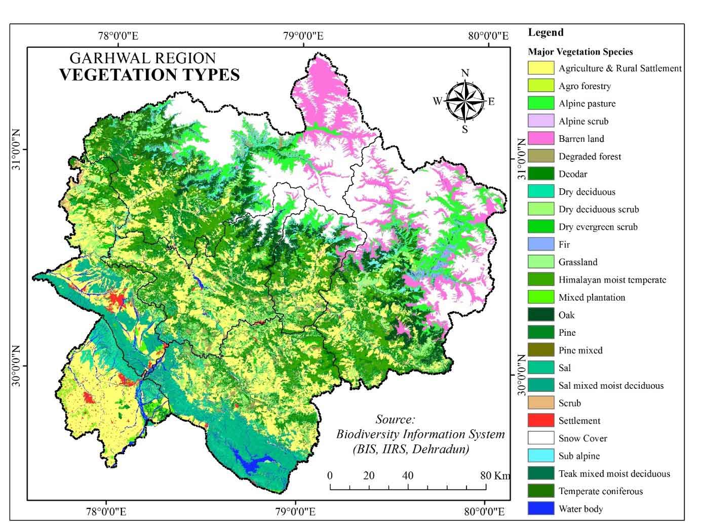
In the lowest altitude zone (<300 m), the predominant land cover is mixed plantation, occupying 139.02km² (53.52%) of the total area. In contrast, barren land constitutes the smallest portion, covering only 0.26km² (0.01%) (Table 4). Apart from mixed plantations, the region is characterized by diverse forest types, including dry deciduous forests, teak mixed moist deciduous forests, degraded forests, dry deciduous scrub, grasslands, pine forests, sal mixed moist deciduous forests, sal forests, and Himalayan moist temperate forests (Figure 7). The lower piedmont areas the dominated by grasslands and the largely fragmented woody tree species and major occupied by the fertile Ganga-Yamuna Rivers plain, where intensive agriculture and urbanisation taking place, hence forests cover is declining rapidly, mostly in the Doon and Dwar region, especially in the vicinity of reserved forest areas (Joshi et al., 2011; Sati and Kumar, 2023).
4.3.2 Sub-tropical natural vegetation (301-800m)
Sal forests dominate this altitude zone, covering 872.20 km² (81.15%) of the total area, while temperate coniferous forests occupy only a minimal portion of 0.98 km² (Table 4). Additionally, several other forest types are present in this zone, including pine mixed forests, dry deciduous forests, sal mixed moist deciduous forests, teak mixed moist deciduous forests, mixed plantations, grasslands, degraded forests, dry deciduous scrub, scrublands, pine forests, Himalayan humid temperate forests, and subalpine forests (Figure 7). The major part of this zone is protected for wildlife corridors by Rajaji National park and Corbett National park, experiencing anthropogenic pressure threatening wildlife and forests. These protected areas are the source of various products extracted and utilizing for local people's livelihood (Negi et al., 1999; Joshi et al., 2011; Gupta et al., 2020).
4.3.3 Warm temperate natural vegetation (801-1600m)
In the warm temperate altitude zone (801-1600 m), dry deciduous scrub is the most dominant vegetation type, covering 1152.26 km² (65.57%) of the total area, while fir occupies the smallest extent at just 0.01 km² (0.01%) (Table 4). This zone also features a diverse range of forest types, including scrub, degraded forest, pine, dry evergreen scrub, grassland, pine mixed forests, sal mixed moist deciduous forests, sal forests, dry deciduous forests, Himalayan humid temperate forests, deodar forests, subalpine forests, temperate coniferous forests, mixed plantations, alpine pastures, barren land, oak forests, and teak mixed moist deciduous forests (Figure 7). Areas having moderate population density in the upper Shiwalik and lesser Himalayan region besides the agriculture, settlement, and grasslands, the major part is occupied by sal mixed deciduous woody forest species. The local people primarily use it for fuelwood, and their leaves were used for fodder and manure production (Singh et al., 2010; Negi et al., 2011; Dhanai et al., 2014).
Table 5. Block-wise Population distribution
|
Classes |
Density |
Blocks |
No. of blocks |
|
Very Low Dense |
< 75 |
Joshimath, Bhatwari, Mori, Ukhimath, Yemkeshwar, Ghat, Tharali |
7 |
|
Moderate Dense |
76 - 150 |
Dasholi, Bhilangana, Kote, Chakrata, Rikhnikhal, Jahrikhal, Purola, Naugaon, Dwarikhal, Kalsi, Narayanbagar, Karanprayag, Dewal, Jaunpur, Dunda, Nainidanda, Thalisain, Pokhari, Pokhra |
19 |
|
Highly Dense |
151 - 300 |
Ekeshwar, Jakholi, Dogadda, Kajikhal, Dhauladhar, Devprayag, Pavo, Kirtinagar, Gairsain, Chinyali Saur, Agastyamuni, Jakhridhar, Narandranagar |
13 |
|
Very High Dense |
> 300 |
Chamba, Pauri, Bironkhal, Pratapnagar, Khirsu, Khanpur, Baharadabad, Bhagwanpur, Doiwala, Sahaspur,Vikasnagar, Nersen, Laksar, Rajpura, Roorkee |
15 |
4.3.4 Cool temperate natural vegetation (1601-2400m)
In the cool temperate zone (1601-2400 m), the Himalayan moist temperate forest dominates the landscape, covering a vast 1798.53km² (69.15%) of the area. In contrast, the teak mixed moist deciduous forest is barely present, occupying just 0.01km² (0.03%) (Table 4). Given the region’s climate, a small portion-1.34km² (0.02%)-is covered by snow. Beyond these, the area is home to a diverse mix of forest types, including pine, grasslands, dry evergreen scrub, degraded forests, deodar, oak, fir, alpine pastures, and several others, each contributing to the rich ecological tapestry of the region (Figure 7). This zone signifies its rich biodiversity due to very dense moist temperate forests, especially Deodar tree cover; therefore, the extensive area is conserved in the form of national parks, wildlife sanctuaries, and conservation reserves, i.e., Nandadevi Biosphere reserve (Nandadevi National park, and Valley of Flowers); Kedarnath wildlife reserve, Govind National parks, and sanctuary and Gangotri National Park, etc. (Chaudhary et al., 2018). The people residing in the forest areas' proximity are primarily involved in the non-timber forest produces (NTFP), fuelwood, fodder, and collect various medicinal plant species for their livelihood, shown in Table 6. In the region, major NTFP collection from forest area is lichens, honey, dwarf bamboo (Drepanostachyum falcatum), resin (oleoresins), wild fruits, i.e., Kafal (Myrica esculenta), Indian gooseberry (Phyllanthus emblica), mushrooms (Agaricus bisporus), Rhododendron flowers, and Fiddlehead ferns (Matteuccia struthiopteris), other flowers medicinal plants, etc.
Table 6. Relative relief and population density
|
Block Name |
Relative relief (RR) |
SD of RR |
Pop. density |
Block name |
Relative relief |
SD of RR |
Pop. density |
|
(person/km2) |
(person/km2) |
||||||
|
Joshimath |
1448 |
197.09 |
11 |
Jakholi |
557 |
97.59 |
161 |
|
Bhatwari |
1180 |
166.75 |
17 |
Dogadda |
611 |
112.99 |
167 |
|
Mori |
1322 |
121.9 |
24 |
Kajikhal |
301 |
66.62 |
167 |
|
Ukhimath |
897 |
141.37 |
49 |
Dhauladhar |
458 |
72.28 |
170 |
|
Yemkeshwar |
673 |
139.2 |
71 |
Devprayag |
510 |
93.16 |
175 |
|
Ghat |
793 |
129.21 |
71 |
Pavo |
288 |
53.03 |
176 |
|
Tharali |
510 |
97.55 |
75 |
Kirtinagar |
569 |
95.95 |
179 |
|
Dasholi |
648 |
117.88 |
81 |
Gairsain |
555 |
116.49 |
187 |
|
Bhilangana |
786 |
115.76 |
82 |
Chinyali Saur |
440 |
85.76 |
201 |
|
Kote |
369 |
77.37 |
84 |
Agastyamuni |
384 |
64.55 |
226 |
|
Chakrata |
564 |
82.53 |
84 |
Jakhridhar |
709 |
104.7 |
229 |
|
Rikhnikhal |
404 |
67.75 |
88 |
Narandranagar |
602 |
100.44 |
237 |
|
Jahrikhal |
452 |
103.36 |
88 |
Chamba |
313 |
51.12 |
304 |
|
Purola |
522 |
97.68 |
89 |
Pauri |
392 |
78.65 |
308 |
|
Naugaon |
640 |
113.57 |
93 |
Bironkhal |
348 |
60.3 |
341 |
|
Dwarikhal |
442 |
84.03 |
99 |
Pratapnagar |
719 |
106.22 |
353 |
|
Kalsi |
730 |
195.87 |
107 |
Khirsu |
348 |
51.91 |
364 |
|
Narayanbagar |
363 |
67.16 |
110 |
Khanpur |
31 |
5.8 |
419 |
|
Karanprayag |
411 |
75.34 |
116 |
Baharadabad |
266 |
51.24 |
444 |
|
Dewal |
775 |
139.24 |
117 |
Bhagwanpur |
266 |
54.28 |
477 |
|
Jaunpur |
329 |
60.43 |
122 |
Doiwala |
635 |
96 |
605 |
|
Dunda |
498 |
75.49 |
124 |
Sahaspur |
689 |
157.08 |
617 |
|
Nainidanda |
409 |
72.08 |
126 |
Vikasnagar |
241 |
58.68 |
896 |
|
Thalisain |
367 |
65.05 |
130 |
Nersen |
81 |
10.76 |
1325 |
|
Pokhari |
504 |
84.32 |
137 |
Laksar |
30 |
5.92 |
2007 |
|
Pokhra |
332 |
59.95 |
141 |
Rajpura |
546 |
178.36 |
2197 |
|
Ekeshwar |
337 |
65.4 |
150 |
Roorkee |
42 |
7.13 |
2206 |
4.3.5 Cold temperate natural vegetation (2401-3200m)
In the 2401-3200 m altitude zone, oak forests dominate the landscape, covering 793.57 km² (78.64%) of the area. On the other hand, teak mixed moist deciduous forests are almost negligible, occupying just 0.06 km² (0.06%). Due to the colder climate, a small portion of the region-23.34 km² (0.42%)-remains under snow cover (Table 4). Apart from oak, this zone also supports a variety of other forest types, including temperate coniferous, fir, deodar, subalpine, Himalayan moist temperate, grasslands, dry evergreen scrub, alpine pastures, degraded forests, alpine scrub, pine, and several others, each playing a role in the region's diverse ecosystem (Figure 7). Moreover, the rich biodiversity is not limited up to the lower zones. The maximum portion of oak, deodar, and fir forests species are dominating this zone. Besides this, a large portion of this zone implies in grasslands. Alike the cool temperate zone, this zone also a hotspot for the NTFP and medicinal plant collection. In this region, various forest species areon the verge of extinction due to indiscriminate exploitation (Bisht et al., 2006; Nautiyal et al., 2005; Negi et al., 2011).
4.3.6 Sub-alpine natural vegetation (3201-4000m)
In the Sub-Alpine zone (3201-4000 m), alpine scrub forests dominate, covering 52.72 km² (65.65%) of the area, while scrub forests occupy the smallest portion, just 0.09 km² (0.14%). Due to the cold climatic conditions, a significant part of the region-266.27 km² (4.83%)-remains under snow cover (Table 4). In addition to alpine scrub, this zone also supports various other forest types, including subalpine forests, alpine pastures, fir, deodar, barren land, temperate coniferous forests, oak, dry evergreen scrub, mixed plantations, degraded forests, sal mixed moist deciduous, grasslands, sal, pine, teak mixed moist deciduous, dry deciduous scrub, and Himalayan moist temperate forests (Figure 7).There is a significant decline in the various characteristics of the forest diversity observed across this altitudinal stratum, indicating that the sub-alpine forest transition in west Himalaya exhibits diversity in compositional patterns. The variations in species diversity indicate a high degree of heterogeneity in the landscape and disturbance regimes (Bahukhandi et al., 2024). Regional distribution of species richness is often analyzed, which have implications for many interactive causes, such as geographical location, plant production, competition, regional species dynamics, evolutionary and historical development, environmental variables, regional species pool, and anthropogenic activities (Nandy et al., 2011; Singh, 2019).
4.3.7 Snow cover area (> 4000m)
This zone, reaching elevations of up to 4000 meters, is primarily known as the glacial cover zone due to its vast snow-covered expanse, which spans 5222.94 km² (94.72%). Apart from the glacier-dominated landscape, barren land represents the largest forested area, covering 1677.87 km² (78.57%), while scrub forests occupy the smallest portion, just 0.01 km² (0.01%) of the total area (Table 4). Other forest types found in this high-altitude zone include alpine pastures, alpine scrub, sub-alpine forests, fir, mixed plantations, dry evergreen scrub, deodar, sal mixed moist deciduous, oak, temperate coniferous forests, degraded forests, teak mixed moist deciduous, and sal (Figure 7).
In addition to NTFP collection, grazing-based livestock husbandry plays a vital role in the Himalayan region's high altitude inhabitants' economy (Negi et al., 2010; Singh, 2019). But the deterioration of grazing and pasture lands, these huge livestock resources are becoming a liability and endangering the very existence of our valuable forests (Rawat, 2010). Seasonal migration of livestock in search of fodder and livelihood is an ancient phenomenon in the Central Himalayas. Livestock activities and various products of this seasonal dwelling were an integral part of the Himalayan village life. They provided opportunities for additional income generation (Sharma et al., 2009b). Growing livestock population, reducing fodder production from agriculture, and evolving cropping patterns resulted in more intensive grazing in forests (Saxena et al., 2005). Temporary, seasonal settlements of grazers on the high hills alpine zone are locally known as Kharak (Sati, 2008). These Kharaks are the summer camps of local people and their grazing animals due to the lack of fodder and grazing around the lower regions' permanent settlement. The entire agricultural land is under Kharif crops, so that the local people migrated there for grazing cattle to upland pastures in temporary settlements. The families stay there almost the April to October, and the cattle are kept on free grazing. In addition to this, crops like potato, amaranth, and kidney bean are cultivated around the camps, and generally one crop is harvested throughout this period (Kumar et al., 2020; Shiva et al., 2005).
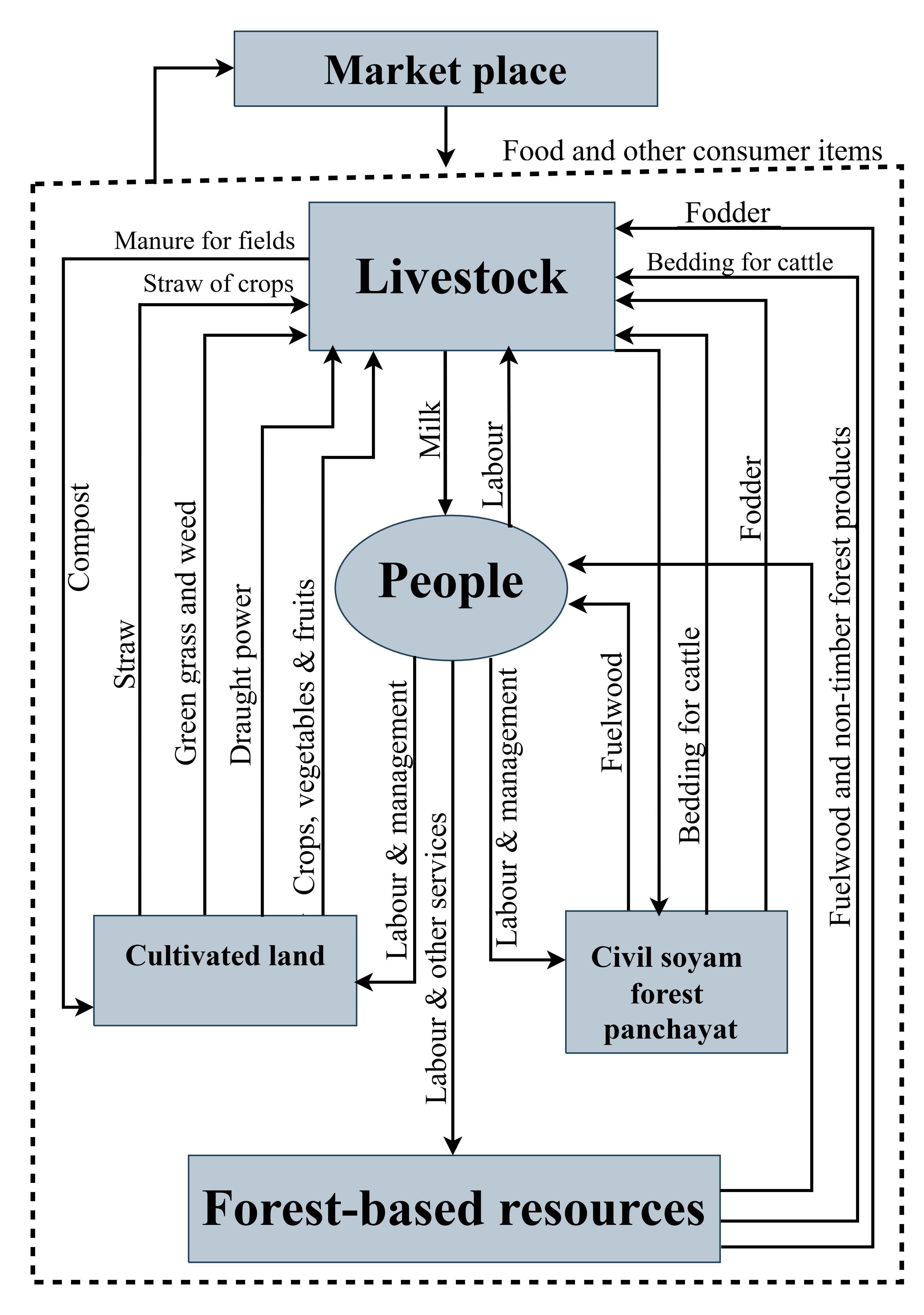
The people in the whole Himalayan region highly depend on forest-based ecosystem services. Figure 8 indicates that the farming communities follow the agro-forest-livestock based system for their livelihood. The larger part of the services that they received is associated with their livestock rearing and fuel wood (Table 8). The adjacent Civil Soyam forest areas are the prime source of most of the habitations in the rural areas in this region. It was also observed during the several visits in this region that Non-timber forest products (NTFPs) play a vital role among the rural population and provide an economical source and subsistence living. Fuel wood, flowers, fruits, nuts, medicinal plants, wild edible vegetables, house building materials etc., are an integral part of day-to-day livelihood activities, especially for people living in forest fringe. In areas above 2000m altitude, or villages with access to high altitude pastures, a very significant proportion of the population, roughly over 30% of households, depending on NTFPs gathering for a substantive part of their earnings (Semwal et al. 2007).
Lichens, Moss, Cinnamomum Tamala, Resin (Pinus roxburghii), Taxus, Behera (Terminalia bellirica), Harra (Terminalia chebula), Ritha (Sapindus mukorossi), Kafal (Myrica Esculenta), Burans Flower (Rhododendron arboretum), Ringal (Drepanostachyum Falcatum and Thamnocalamus Pathiflorus), Himalayan Morel Mushroom (Morchella Esculenta), etc. are the major forest product that contributes as an economical source of the rural economy in this region. The larger part of these sources is associated with sub-tropical and temperate areas where very little population is concentrated in valleys of the lesser and greater Himalayan region (Figure 5).
4.4 Population Distribution
According to the population census 2011, the block-wise population density was analyzed to interpreting population distribution in the Garhwal region (Table 6). Garhwal region occupies about 5857294 (58%) population in 32450km2 (60.7%) area with an average density of 181 persons per km2 (Table 1). It varies from the south (Ganges Great Plains) to the north (Greater Himalayan ranges). The population density is classified into four categories: very few dense to very high dense (Figure 3).
4.4.1 Areas with a low population density
A considerable area falls in this category, which is the part of the Greater Himalayas. Joshimath (11), Bhatwari (17), Mori (24), Ukhimath (49), Yemkeshwar (71), Ghat (71), and Tharali (75) blocks (Table 6), where population density is very low (< 75) these blocks mostly belong to Chamoli, Uttarakashi and Rudraprayag district (Figure 3). This very low density is the diverse condition of climate, topography and forest diversity (Figure 10).
4.4.2 Areas with a moderate population density
Blocks that have population density ranging from 75 to 150 person per km2 (Table 3), Dasholi (81), Bhilangana (82), Kote (84), Chakrata (84), Rikhnikhal (88), Jahrikhal (88), Purola (89), Naugaon (93), Dwarikhal(99), Kalsi(107), Narayanbagar (110), Karanprayag(116), Dewal (117), Jaunpur (122), Dunda (124), Nainidanda (126), Thalisain (130), Pokhari (137) and Pokhra (141) (Figure 3). All these 19 administrative blocks remain in the category that belongs to Chamoli Uttarakashi, Rudraprayag, Tehri Garhwal, Pauri Garhwal, and the northern areas of Dehradun. Due to highly dissected topographical conditions, these areas are less inhibited in this region (Figure 10).
4.4.3 Areas with a high population density
13 blocks fall under this category of population density, respectively Ekeshwar (150), Jakholi (161), Dogadda (167), Kajikhal (167), Dhauladhar (170), Devprayag (175), Pavo (176), Kirtinagar (179), Gairsain (187), Chinyali Saur (201), Agastyamuni (226), Jakhridhar (229) and Narandranagar (237) (Figure 3) that are distinguished with highly dense (151 - 300). In this zone, favourable geographical conditions for agriculture and other economic activities are found (Figure 10).
4.4.4 Area with a very high population density
In this group, almost all development blocks of Dehradun and Haridwar represents very high population density. As many as 15 blocks, viz. Chamba (304), Pauri (308), Bironkhal (341), Pratapnagar (353), Khirsu (364), Khanpur (419), Baharadabad (444), Bhagwanpur (477), Doiwala (605), Sahaspur (617), Vikasnagar (896), Nersen (1326), Laksar (2007), Rajpura (2198) and Roorkee (2206) (Figure 3). Besides Haridwar and Dehradun District, there are 2 blocks from Pauri and 2 from Tehri districts, where the population density is found very high because of urbanization development in these areas. In Haridwar and Dehradun, a high population concentration is because of plain surface and flat valleys (Figure 10). In these districts, agricultural and industrial activities play a significant role in urbanisation.
4.5 Association Between Relative Relief and Population Density
High to moderately dissected and rugged terrain in this stretch of the Himalayan part is very significant to explain the population's distribution with topographic relief of land surface variations. In this discussion, it is imperative to explain the topographic features of the terrain. Garhwal region has five uniform topographic zones from south to north plain surface, i.e., low relief surface, moderately high relief surface, high relief and steep slope surface, and very high relief surface in upper ridges. The block-wise population density indicates the blocks found in the northern upper parts of the region have very low population density up to 11 due to severe diverse conditions of climate and topographic features of the land surface (Figure 10).
The region has high relative relief ranging from 525-825m occupying about 28.91 %, with 15.13% of the population experiencing low population density (78-150m). These areas imply the region's central part representing the upper lesser Himalayan region, where mostly moist deciduous high dense forests exist in Figure 7. The areas have a 14.44% population with high density confining along the Alaknanda and Bhagirathi Rivers valleys (14.95% area), where substantial fertile land is cropping. The soils of this lower part of the lesser Himalayan region are affected mainly due to evolving cropping patterns and unavailability of irrigation sources-most of the farmers are involved in traditional farming with irrational practices that lead to less productivity. The southern parts are indicating relative relief < 325m showing Doon, Dwar, Bangur, and Khadar (alluvial plain) region that covers about 15% area of the region embracing more than half of the population of the region (65%) demonstrating enormous population pressure due to convenient, excellent accessibility, temperate climatic conditions and fertile cropping land (Table 7 and Figure 7). During the last decades, this region undergoing increasing population pressure due to haphazard urbanization, industrialization. The association of the land topography and population indicating huge population imbalances in this part of the Uttarakhand state that may be good or bad for the ecological environment without taking manageable measures in various aspects.
Table 7. Distribution of population
|
Classes |
Area |
Population |
Population density (person/km2) |
||
|
km2 |
% |
Total |
% |
||
|
Very low dense |
13370.50 |
41.15 |
333679 |
05.33 |
045 |
|
Moderate dense |
9393.41 |
28.91 |
947797 |
15.13 |
106 |
|
Highly dense |
4856.58 |
14.95 |
904160 |
14.44 |
187 |
|
Very high dense |
4869.48 |
14.99 |
4077559 |
65.10 |
858 |
|
Total |
32490 |
100 |
6263195 |
100 |
1196 |
Rural food and livelihoods are collected from forest-based subsistence agriculture (Tiwari, 2000; Sood, 2005). However, due to the climatic and land restrictions and insufficient agricultural production, significant food deficits and many male adults migrate from this region to seek employment and livelihoods. Marginalized farmers and landless households are mainly affected, primarily economically backward groups and severely low-income families. Thus, in this field, a community-based framework for forestry, land and water management, and the generation of sustainable off-farm opportunities are required to implement at local levels (Tiwari and Joshi, 2012). Regions where land consolidation is accomplished, organic farming, horticulture, and medicinal/aromatic plants are promising as viable sources of livelihood for the local population. Simultaneously, the provision of business linkages and marketing resources for potential agro-entrepreneurs is also critical. This lack of knowledge on future livelihoods impedes efforts to support livelihoods. Consequently, although it is necessary to establish and revise policies, it is equally vital to disseminate information and enforce current policies and schemes in both the agricultural and non-farming sectors (Naudiyal et al., 2019).
As we move towards Southern progression, we found that population density increases with decreasing topographic relief of the land surface (Figure 9). The maximum population reaches up to about 2200 persons/ km2. Where relative relief of the terrain is very low, representing flatted valleys and Ganges Great Plains in Haridwar and Dehradun districts of the region. In these areas, favorable conditions for habitation development like climate, topography, accessibility, resources, etc., exist. The negative correlation between population density and relative relief has found -0.69 (P<0.05), reflecting that the population is inversely distributed with relative relief of the surface in this region (Figure 9). The eloquent testimony of the highly unequal distribution of the population that about 65% of the region's population inhabited in 14% area of the region and contrast, only 5.33% of the population is dispersed in 41% of the total land of this region (Table 7). The studies carried out by Nand and Kumar (1989), Joshi and Gairola (2004), Pramanik (2016) witnessed the impact of altitude on land use and land cover. The most intense human activities were found to be in the lower valley areas between 900m and 2200m, demonstrating that human beings are residing at higher altitudes satisfying their food, fodder, and fuel requirements, which are the only places where forest cover exists.
Forest plays pivotal importance in sustaining the workforce in the Himalayan region. Forests not only maintaining the ecological system but also it is strengthening the geographical region socio-economically. In the upper areas of the region (>1800m), very few populations inhabited due to livelihood resources' availability. Local availability of feed resources for livestock, fuel wood, limited rearing facilities, marketing facilities, transportation and communication services, and so on are significant factors on which local livelihood resources depend in the region. It is also observed that almost all the families of rural areas use fuel wood for cooking food, lighting, water boiling, and space heating (Figure 8). It was also observed that fuel wood consumption varies with the lower region season but constant in the higher region because of climatic severity. Some common plant species were used as fuel and fodder for animals shown in Table 8. Villages preferred those species most suitable for fuel characteristics that produce less smoke and flame gradually. The durability of ember and high calorific value makes less smoke and has enough wood hardness. The people collect fuel wood and fodder from nearby Civil Soyam Panchayat forest (community forest), but sometimes people have to travel a long distance in the reserved forest. In a study, it was found that after introducing LPG in rural areas, the old energy consumption pattern has changed that not only reducing the pressure on women labor but also releasing the dependency of people on the forest to energy supply (Dhanai et al., 2015; Dhyani and Dhyani, 2020). This is strengthening ecological resources in terms of forest enhancement and empowering women in terms of health.
Table 8. Major plant species useful for fuel and fodder
|
Plant Species |
Local Name |
lower altitude (<1500 m) |
middle altitude (1500-2500 m) |
higher altitude (>2500) |
|
Abies pindrow |
Raga |
Y |
Y |
|
|
Alnus nepalensis |
Usth |
Y |
Y | |
|
Bauhinia variegate |
Quiral |
Y |
||
|
Berberis aristata |
Kilmore |
Y |
Y |
|
|
Betula alnoides |
Sor |
Y |
Y |
|
|
Carpinus viminea |
Chamkharikh |
Y |
Y |
|
|
Cedrus deodara |
Deodar |
Y |
||
|
Celtis australis |
Kharik |
Y |
||
|
Daphniphyllum himalensis |
Dambel |
Y |
||
|
Excoecaria acerifolai |
Gangiva |
Y |
||
|
Ficus roxburghii |
Timla |
Y |
||
|
Fraxinus micrantha |
Anghu |
Y |
||
|
Fraxinus micrantha |
Barara |
Y |
Y |
|
|
Grewia optiva |
Bhimal |
Y |
||
|
Lyonia ovalifolia |
Ayar |
Y |
||
|
Lyonia ovalifolia |
Ayar |
Y |
Y |
|
|
Myrica esculenta |
Kafal |
Y |
Y |
|
|
Pinus roxburghii |
Chir |
Y |
Y |
|
|
Prunus ceresiodes |
Padam |
Y |
Y |
Y |
|
Pyrus pashia buch. |
Melu |
Y |
Y |
Y |
|
Q. glauca |
Faliyat |
Y |
Y |
|
|
Quercus floribunda |
Moru |
Y |
Y |
|
|
Quercus leucotrichophora |
Banj (Tilanj) |
Y |
Y |
Y |
|
Quercus semecarpifolia |
Kharsu |
Y |
||
|
Rhododendron arboretum |
Burans |
Y |
Y |
|
|
Rubus napalensis |
Y |
Y |
||
|
Symplocos paniculata (Thunb.) Miq. |
Lodh |
Y |
Y |
|
|
Toona ciliate |
Tun |
Y |
The populations and communities primarily depend on forest resources for livelihoods and basic requirements such as fuel wood, livestock fodder, and other non-timber forest products (NTFTs) and timber (Malik et al., 2014b). This fuel wood can be readily available without paying any economic cost. Therefore, people prefer to use firewood to supply their energy requirements in the entire Himalayan region (Figure 8).
A clear picture of the nexus between forest and livelihood of the local people is depicted in Figure 8, how livelihood activities of hilly people are intertwined with forests resources. The consumption of fuel wood is influenced by climatic and seasonal effects (Bhatt and Sachan, 2004). There are differences in fuel wood consumption at various altitudes in the hilly regions (Khuman et al., 2015). Multiple studies have been carried out to assess the level and pattern of consumption of fuel wood energy from forests in the Himalayan region. NTFPs play an important role among the rural villagers, which contribute to subsistence living and income. The day-to-day livelihood activities for the area's population, particularly in forest-neighboring regions, include fuel wood, flowers of food, berries, nuts and medicinal plants, edible vegetables, household building materials, etc.
In areas above 2000m altitude, or villages with access to high altitude pastures, a very significant proportion of the population, roughly over 30%, depends on NTFPs gathering for a substantive part of their earnings (Semwal et al., 2007). Jhoola (Lichens), Moss, Tajpata, Resin (Pinus roxburghii), Taxus, Bahera, Harra, Ritha, Kafal, Burans, Ringal, Guchii, and MAPs have emerged as the significant NTFPs collected in the region for medicinal and other industrial use. Alongside this, dried culinary herbs, herb tea, and local niche agro-products also provide alternate livelihood options for the communities of the region. The targeted herb species are (Salvia Rosmarinus) Rosemary, (Petroselinum Crispum), Parsley, (Thymus Serpyllum), Thyme, (Origanum Vulgare), Oregano, (Mentha arvensis), Mint, (Mentha balsamea), Peppermint, (Salvia Officinalis) Sage, (Origanum Majorana) Marjoram, (Ocimum Basilicum) Basil, (Melissa Officinalis) Lemon Balm, (Carum Carvi) Caraway, etc.
In the Himalayas, forest ecosystems and their surrounding communities are among the most ecologically and economically threatened (Singh and Singh, 2020). Thus, the residents of hilly regions remained marginalized in the context of the more extensive development process. Communities in forest ecosystems are dependent on natural resources and biodiversity for food security and livelihoods through fuel wood, fodder, and non-timber forest products (NTFPs) collection. Nowadays, medicinal and aromatic plants (MAPs) and herbs have gained global recognition as raw material sources for pharmaceuticals and traditional health care (Maikhuri et al., 1998; Kandari et al., 2012). The demand for herbal products is huge and increasing daily across the world (Singh 2005). The need for Ayurvedic medicines is expected to rise by 20% in India every year (Tewari et al., 2020).
After careful analysis based on facts mentioned above of the population density incorporated with topographic factors of the Garhwal Himalayan region, particular consideration is to be born in the mind that the fewer population utilizes considerable area resources the upper parts of the population region. Keeping some in view of the mountainous peculiarities, the reasons for this uneven distribution of people are diverse climate conditions, inaccessibility, natural disasters, and lack of necessary human resource development facilities. A long run of time population stretched outside from the remote rural areas towards main developing resource places. Outmigration, particularly within the region, has given new dimensions in the distribution of the population. Interregional and rural-urban migration has also created imbalances in this regard (Mamgain and Reddy, 2017; Joshi, 2018). The following conclusion may be drawn in support of this uneven distribution and density of the Garhwal Himalayan region population. The cumulative and direct influence of ruggedness of terrain, diverse climate, soils, vegetation, and forests can distribute habitation in this region. The study found that there is a close relationship between cultivable land and rural population. Rivers valleys are in this mountainous region boast fertile land where maximum population concentrated, but the distribution is uneven. The lack of necessary facilities such as transport, education, communication, employment, and opportunities in other economic activities resulted in immediate outmigration from this region's interior areas (Mamgain and Reddy, 2017). The availability of drinking water sources is the most deciding factor for the habitation of population in mountains (Thapa et al., 2023). Due to natural disasters, most of the sites are restricted to population distribution. Therefore, physical factors, such as altitude, slope, aspect, and drainage density, play a significant role.
Improving the livestock sector through effective local planning with local people intervention would improve the village economy's socioeconomic status. Local availability of feed resources, livestock genetic resources, animal health services, marketing facilities, transportation and communication services, and so on are significant factors on which regional livestock development planning can be based (Rawal, 2020). Analysing the multi-dimensional role of livestock in mountain farming systems, it became essential to review current planning and policymaking, finding an alternative planning strategy for livestock sector development in mountain areas. The livestock sector is often neglected in institutional planning and policies as well. However, it needs well-planned institutional intervention for socioeconomic development in mountain areas. Furthermore, as implemented in the plains areas, conventional planning is less responsive to mountain specificities. Such planning leads to waste of money and resources, seeks no participation from local people, and ignores local realities (Sati, 2016).
5. Conclusion
The study found that topographical relief, the climate has a significant effect on the spatial distribution of population and communities in mountainous regions by influencing the availability of forest-dependent livelihood services. The population's imbalances are caused due to the severity of climate, toughness of terrain, limited livelihood opportunities, etc. In the greater Himalayan region, where 41.15% area of the region occupying 5.33% population. Due to the low carrying capacity and better for conserving natural resources experiencing immense anthropogenic pressure, especially on forests. It is also evident from the study that the forests play a significant role in carrying forward livelihood resources for the local people inhabiting the vicinity of forest regions, especially livestock husbandry and NTFP. Both resources are prominent among the inhabitants, which provide a substantial income to carry out their household economies. The Garhwal region is the western part of the Indian Himalayan region, where inhabiting communities are primarily dependent on the forests ecosystems; therefore, it is imperative to formulate guidelines at the local and regional level for sustainable management intertwined with United Nation’s sustainable developmental goals for these institutions. Following international and national regulations, the governing authorities and organizations should take action in access and benefit-sharing for native communities, especially high altitudes at block level; administrative regional biodiversity planning body should regulate their proper functioning. These authorities ensure the sustainable management of biological diversity in these areas, which are a high priority. It helps future interventions towards biodiversity conservation and the proper implementation of access and benefit-sharing provisions for the communities living in the region. The region has to begin measures towards different administrative, legal, and policy measures, apart from focusing on capacity building, awareness-raising, developing the legal, regulatory, and market-based instruments and strategies, which are relevant to realize the potential of access and benefit, and harnessing it in sustainable ways.
Conflict of interest
The authors declare that they have no known competing financial interests or personal relationships that could have appeared to influence the work reported in this paper. The submitted work is original has not been published elsewhere in any form or language (partially or in full), unless the new work concerns an expansion of previous work. No conflicts of interest.
Acknowledgements
We extend our sincere gratitude to Prof. M.S. Negi, Department of Geography, Hemvati Nandan Bahuguna Garhwal University for their invaluable guidance, insightful feedback, and generous support throughout this study.
Abbreviations
AHP: Analytic Hierarchy Process; ASTER: Advanced Spaceborne Thermal Emission and Reflection Radiometer; BIS: Biodiversity Information System; CHELSA: Climatologies at High Resolution for the Earth's Land Surface Areas; DEM: Digital Elevation Model; FSI: Forest Survey of India; GHG: Green House Gases; GIS: Geographic Information System; GSI: Geological Survey of India; HFF: Himalayan Frontal Fault; IIRS: Indian Institute of Remote Sensing; LPG: Liquid Petroleum Gas; LULC: Land Use and Land Cover; MAPs: Medicinal and Aromatic Plants; MBT: Main Boundary Thrust; MCT: Main Central Thrust; MFT: Main Frontal Thrust; NTFP: Non-Timber Forest Products; PCA: Principal Component Analysis; RDLS: Relief Degree of the Land Surface; RRLS: Relative Relief of Land Surface; RS: Remote Sensing; USGS: United States Geological Survey; WSA: Watershed Sustainability Assessment.
Article information
- Received
- 28 Dec 2024
- Revised
- 25 Feb 2025
- Accepted
- 25 Feb 2025
- Published
- 13 Mar 2025
- Handling editor
- Professor. Masood Ahsan Siddiqui
- Licence
- CC BY-NC-ND 4.0
- Journal
- Journal of Geographical Studies, ISSN 2582-1083
References
-
Asthana, V. K. and Vir, K., 1991. Cluster analysis in the identification of Morpho unit: Pervikhala drainage basin - A case study. In Sharma, H. S. (Ed.). 1991. Indian Geomorphology: Selected Papers from the 2nd Conference of the Indian Institute of Geomorphologists on Environmental Geomorphology, 123-136. Concept Publishing Company.
-
Bahukhandi, A., Chandra Sekar, K., Negi, V. S., Bisht, K., Tiwari, D. C., Mehta, P., Upadhyay, S., Siddiqui, S. and Ayari-Akkari, A., 2024. Floristic diversity and species composition along altitudinal gradient in the alpine ecosystem of the cold desert region in Western Himalaya, India. Frontiers in plant science, 15, 1469579.
Crossref -
Bhatt, B. P. and Sachan, M. S., 2004. Firewood consumption pattern of different tribal communities in Northeast India. Energy Policy, 32(1), 1-6.
Crossref -
Bhattacharyya, A., Ranhotra, P. S. and Gergan, J. T., 2011. Vegetation vis-a-vis climate and glacier history during 12,400 to 5,400 yr BP from Dokriani valley, Garhwal Himalaya, India. Journal of the Geological Society of India, 77(5), 401-408.
Crossref -
Bhutiyani, M. R., Bhutiyani, M. R., Kale, V. S. and Pawar, N. J., 2009. Climate change and the precipitation variations in the northwestern Himalaya: 1866-2006. International Journal of Climatology.
Crossref -
Bisht, I. S., Rao, K. S., Bhandari, D. C., Nautiyal, S., Maikhuri, R. K. and Dhillon, B. S., 2006. A Suitable site for in situ (on-farm) management of plant diversity in traditional agroecosystems of Western Himalaya in Uttaranchal State: A case study. Genetic Resources and Crop Evolution, 53(7), 1333–1350.
Crossref -
Biswas, S. S., Pal, R., Pramanik, M. K. and Mondal, B., 2015. Assessment of anthropogenic factors and foods using remote sensing and GIS on lower regimes of Kangshabati-Rupnarayan River Basin, India. International Journal of Remote Sensing GIS, 4(2), 77-86.
-
Chakraborty, A., Joshi, P. K. and Sachdeva, K., 2018. Capturing forest dependency in the central Himalayan region: Variations between Oak (Quercus spp.) and Pine (Pinus spp.) dominated forest landscapes. Ambio, 47(4), 504-522.
Crossref -
Chaudhary, S., Kumar, A. and Negi, M. S., 2019. A geospatial appraisal of Garhwal Himalayan bio-geodiversity and its eco-tourism potentials. IJRAR, 6(1), 911-926.
-
Chaudhary, S., Kumar, A., Pramanik, M. and Negi, M. S., 2022. Land evaluation and sustainable development of ecotourism in the Garhwal Himalayan region using geospatial technology and analytical hierarchy process. Environ Dev Sustain, 24, 2225-2266.
Crossref -
Chaudhary, S., Negi, M. S. and Kumar, A., 2018. Ecotourism aesthetics and prospects: A geospatial assessment of Rajaji National Park. Review of Research, 2331(48514), 1-17.
-
Demske, D., Tarasov, P. E., Leipe, C., Kotila, B. S., Joshi, L. M. and Long, T., 2016. Record of vegetation, climate change, human impact and retting of hemp in Garhwal Himalaya (India) during the past 4600 years. The Holocene, 26(10), 1661-1675.
Crossref -
Dhanai, R. and Parmar, M., 2014. Fuelwood and Fodder Consumption Pattern in Uttarakhand Himalayan Watershed. International Journal of Environmental Biology, 4(1), 35-40.
-
Dhanai, R., Negi, R. S., Singh, S. and Parmar, M. K., 2015. Fuelwood consumption by villagers in different altitudinal gradient: A case of Takoligad watershed of Garhwal Himalaya, India. International Journal of Current Engineering and Technology, 5(1), 72-80.
-
Dhyani, S. and Dhyani, D., 2020. Local socio-economic dynamics shaping forest ecosystems in Central Himalayas. In Socioeconomic and Eco-biological Dimensions in Resource use and conservation, 31-60. Springer.
Crossref -
Dhyani, S., Maikhuri, R. K. and Dhyani, D., 2011. Energy budget of fodder harvesting pattern along the altitudinal gradient in Garhwal Himalaya, India. Biomass and Bioenergy, 35(5), 1823-1832.
Crossref -
Ellu, G. and Obua, J., 2005. Tree condition and natural regeneration in disturbed sites of Bwindi Impenetrable forest national park, Southwestern Uganda. Trop Ecol 46(1), 99-111.
-
Fielding, E. J., Isacks, B., Barazangi, M. and Duncan, C., 1994. How flat is Tibet? Geology 22, 163-167.
Crossref -
Fragkias, M. and Seto, K. C., 2009. Evolving rank-size distributions of intra metropolitan urban clusters in South China. Comput Environ Urban Syst, 33, 189-199.
Crossref -
FSI [Forest Survey of India], 2003. The State of Forest Report, Dehradun, FSI, Ministry of Environment and Forests, Government of India. 2003, 134.
-
Gupta, N., Everard, M. and Namchu, C. V., 2020. Declining native fish, diminishing livelihood security: The predicament of Indian Himalayan communities. International Journal of River Basin Management, 1-5.
Crossref -
Heim, A. and Gansser, A., 1939. Central Himalaya, geological observations of the Swiss expeditions 1936. Mem. Soc. Helv. Sci. 73.
-
Hui, Y., Yong, L., Shaoquan, L., Yong, W., Yong, Y. and Weidong, L., 2015. The influences of topographic relief on spatial distribution of mountain settlements in Three Gorges Area. Environmental Earth Sciences, 74(5), 4335-4344.
Crossref -
Joshi, B., 2018. Recent trends of rural outmigration and its socio-economic and environmental impacts in Uttarakhand Himalaya. Journal of Urban and Regional Studies on Contemporary India, 4(2), 1-14.
-
Joshi, P. K. and Gairola, S., 2004. Land cover dynamics in Garhwal Himalayas- A case study of balkhila sub-watershed. Journal of the Indian Society of Remote Sensing, 32(2), 199-208.
Crossref -
Joshi, P. K., Yadav, K. and Sinha, V. S. P., 2011. Assessing impact of forest landscape dynamics on migratory corridors: A case study of two protected areas in Himalayan foothills. Biodiversity and Conservation, 20(14), 3393-3411.
Crossref -
Kan, A., Zhu, L. D., Gong, J. H. and Chen, Z. L., 2006. Development of the swath profile tool based on ArcView GIS and its application in morphometric analysis. J Chengdu Univ Tech Sci-Tech, 33, 64-69
-
Kandari, L. S., Phondani, P. C., Payal, K. C., Rao, K. S. and Maikhuri, R. K., 2012. Ethnobotanical study towards conservation of medicinal and aromatic plants in upper catchments of Dhauli Ganga in the central Himalaya. Journal of Mountain Science, 9(2), 286-296.
Crossref -
Kaushik, S. D., 1962. Climatic zones and their related socio-economy in Garhwal Himalaya. Geog. Review, 24(3-4), 29.
-
Kharkwal, G., Mehrotra, P., Rawat, Y. S. and Pangtey, Y. P. S., 2005. Phytodiversity and growth form in relation to altitudinal gradient in the Central Himalayan (Kumaun) region of India. Curr Sci, 89(5), 873-878.
-
Kharkwal, S. C., 1993. Physico-Cultural Environment and Development in UP Himalaya. Nutan Publications.
-
Khuman, Y. S. C., Raina, N., Pandey, R. and Rao, K. S., 2015. Fuelwood assessment at the micro-watershed level: A case study in Garhwal Himalaya, India. Chinese Journal of Population Resources and Environment, 13(2), 177-186.
Crossref -
Kumar, A., Pramanik, M., Chaudhary S. and Negi, M. S., 2020. Land evaluation for sustainable development of Himalayan agriculture using RS-GIS in conjunction with analytic hierarchy process and frequency ratio, Journal of the Saudi Society of Agricultural Sciences.
Crossref -
Kumar, A., Singh, S., Pramanik, M., Chaudhary, S., Maurya, A. K. and Kumar, M., 2021. Watershed prioritisation for soil erosion mapping in the Lesser Himalayan Indian basin using PCA and WSA methods in conjunction with morphometric parameters and GIS-based approach. Environment, Development and Sustainability, 24, 3723-3761.
Crossref -
Kumar, M., Sharma C. M. and Rajwar, G. S., 2004. A study on the community structure and diversity of a sub-tropical forest of Garhwal Himalayas. Indian Forester, 130 (2), 207-214.
-
Kuniyal, H. B., Semwal, S., Tiwari, O. P. and Sharma, C. M., 2024. Forest composition and resource utilization patterns in relation to anthropogenic pressure in moist temperate forests of the Garhwal Himalaya. Environment and Ecology, 42(4A), 1726-1735.
-
Maikhuri, R. K., Nautiyal, S., Rao, K. S. and Saxena, K. G., 1998. Role of medicinal plants in the traditional health care system: A case study from Nanda Devi Biosphere Reserve. Current Science, 152-157.
-
Malik, Z. A., Bhat, J. A. and Bhatt, A. B., 2014. Forest resource use pattern in Kedarnath wildlife sanctuary and its fringe areas (A case study from Western Himalaya, India). Energy Policy, 67, 138-145.
Crossref -
Malik, Z. A., Hussain, A., Iqbal, K. and Bhatt, A. B., 2014. Species richness and diversity along the disturbance gradient in Kedarnath Wildlife Sanctuary and its adjoining areas in Garhwal Himalaya, India. Int J Curr Res, 6, 10918-10926.
-
Mamgain, R. P. and Reddy, D. N., 2017. Outmigration from the hill region of Uttarakhand: Magnitude, challenges, and policy options. In Rural Labour Mobility in Times of Structural Transformation, 209-235. Springer.
Crossref -
Mandal, P., Prathigadapa, R., Srinivas, D., Saha, S. and Saha, G., 2023. Evidence of structural segmentation of the Uttarakhand Himalaya and its implications for earthquake hazard. Scientific Reports, 13, 2079.
Crossref -
Mondal, B., Chakraborti, S., Das, D. N., Joshi, P. K., Maity, S., Pramanik, M. K. and Chatterjee, S., 2020. Comparison of spatial modelling approaches to simulate urban growth: A case study on Udaipur city India. Geocarto International, 35(4), 411-433.
Crossref -
Mondal, B., Dolui, G., Pramanik, M., Maity, S., Biswas, S. S. and Pal, R., 2017. Urban expansion and wetland shrinkage estimation using a GIS-based model in the East Kolkata Wetland, India. Ecological Indicators, 83, 62-73.
Crossref -
Nand, N. and Kumar, K., 1989. The holy Himalaya: A geographical interpretation of Garhwal. Daya Books.
-
Nandy, S., Kushwaha, S. P. S. and Dadhwal, V. K., 2011. Forest degradation assessment in the upper catchment of the river Tons using remote sensing and GIS. Ecological Indicators, 11(2), 509-513.
Crossref -
Naudiyal, N., Arunachalam, K. and Kumar, U., 2019. The future of mountain agriculture amidst continual farm-exit, livelihood diversification and outmigration in the Central Himalayan villages. Journal of Mountain Science, 16(4), 755-768.
Crossref -
Nautiyal, S., Rajan, K. S. and Shibasaki, R., 2005. Interaction of biodiversity and economic welfare- A case study from the Himalayas of India. Journal of Environmental Informatics, 6(2), 111-119.
-
Negi, A. K., Bhatt, B. P. and Todaria, N. P., 1999. Local population impacts on the forests of Garhwal Himalaya, India. Environmentalist, 19(4), 293-303.
Crossref -
Negi, V. S., Maikhuri, R. K. and Rawat, L. S., 2011. Non-timber forest products (NTFPs): A viable option for biodiversity conservation and livelihood enhancement in central Himalaya. Biodiversity and Conservation, 20(3), 545-559.
Crossref -
Negi, V. S., Maikhuri, R. K., Rawat, L. S. and Vashishtha, D. P., 2010. The livestock production system in a village ecosystem in the Rawain Valley, Uttarakhand, Central Himalaya. International Journal of Sustainable Development and World Ecology, 17(5), 431-437.
Crossref -
Pal, R., Biswas, S. S., Mondal, B. and Pramanik, M. K., 2016. Landslides and foods in the Tista basin (Darjeeling and Jalpaiguri Districts): Historical evidence, causes and consequences. Journal of Geophysics Union, 20(2), 209-215.
-
Pal, R., Biswas, S. S., Pramanik, M. K. and Mondal, B., 2016. Bank vulnerability and avulsion modelling of the Bhagirathi-Hugli river between Ajay and Jalangi confluences in lower Ganga Plain, India. Model Earth System Environment, 2, 65.
Crossref -
Pandey, A. N. and Singh, J. S., 1985. Mechanism of ecosystem recovery: A case study of Kumaun Himalaya. Recreation and Revegetation Research, 3, 271-292.
-
Partap, T., 2011. Hill agriculture : Challenges and opportunities. International Journal of Agriculture Economics, 66(1), 33-52.
-
Pramanik, M. K., 2016. Site suitability analysis for agricultural land use of Darjeeling district using AHP and GIS techniques. Modeling Earth Syst. Environ., 2(2), 56.
Crossref -
Quamar, M. F., Singh, A. K., Joshi, L. M., Kotila, B. S., Singh, D. S., Simion, C. A., Seva, T. and Prasad, N., 2023. Vegetation dynamics and hydro-climatic changes during the Middle Holocene from the Central Himalaya, India. Quaternary, 6(1), 11.
Crossref -
Rao, K. S., Semwal, R. L., Maikhuri, R. K., Nautiyal, S., Sen, K. K., Singh, K., Chandrasekhar, K. and Saxena, K.G., 2003. Indigenous ecological knowledge, biodiversity and sustainable development in the central Himalayas, Tropical Ecology, 44 (1), 93-111.
-
Rawal, R. S., 2020. Complying with biodiversity conservation initiative that holds the future for Himalayan people. In Himalayan Biodiversity and Future Solutions. G.B. Pant ‘National Institute of Himalayan Environment (NIHE) Kosi-Katarmal, Almora, Uttarakhand, 1, 13-14.
-
Rawat, V. S., 2010. Problems of animal grazing in Uttarakhand Himalaya. Researcher, 2(5), 81-85.
-
Sandhu, H. and Sandhu, S., 2015. Poverty, development, and Himalayan ecosystems. AMBIO, 44(4), 297-307.
Crossref -
Sati, V. P. and Kumar, S., 2023. Declining agriculture in Garhwal Himalaya: Major drivers and implications. Cogent Social Sciences, 9(1).
Crossref -
Sati, V. P. and Singh, R. B., 2010. Prospects of sustainable livestock farming in the Uttarakhand Himalaya, India. Journal of Livestock Science, 1, 9-16.
-
Sati, V. P., 2008. Natural resource management and food security in the Alaknanda Basin of Garhwal Himalaya. ENVIS Bulletin: Himalayan Ecology, 16(2), 1-11.
-
Sati, V. P., 2016. Livestock farming in the Uttarakhand Himalaya, India: Use pattern and potentiality. Current Science, 111(12), 1955-1960.
-
Saxena, K. G., Maikhuri, R. K. and Rao, K. S., 2005. Changes in agricultural biodiversity: Implications for sustainable livelihood in the Himalaya. Journal of Mountain Science, 2(1), 23-31.
Crossref -
Semwal, D. P., Saradhi, P. P., Nautiyal, B. P. and Bhatt, A. B., 2007. Current status, distribution and conservation of rare and endangered medicinal plants of Kedarnath Wildlife Sanctuary, Central Himalayas, India. Current Science, 1733-1738.
-
Sharma, C. and Gupta, A., 1997. Vegetation and climate in Garhwal Himalaya during early holocene: Deoria Tal. Journal of Palaeosciences, 46(3), 111-116.
Crossref -
Sharma, C. M., Gairola, S., Kumar, M., Rawat, Y. S. and Bagwari, H. K., 2009. Resource utilisation in village ecosystem of temperate zone of Garhwal Himalaya. Indian Journal of Agroforestry, 11(2), 94-1.
-
Sharma, C. M., Suyal, S., Gairola, S. and Ghildiyal, S. K., 2009. Species richness and diversity along an altitudinal gradient in moist temperature forest of Garhwal Himalaya. J Am Sci, 5,119-128.
-
Shiva, V., Singh, V., Dankelman, I., Negi, B. and Singh, S., 2005. Biodiversity, Gender and Technology in Mountain Agriculture.
-
Singh, D., Srivastava, R. K. and Khanduri, V. P., 2005. Marketing strategies and trade of medicinal plants in Uttaranchal: Present and future prospects. Indian Forester, 131(3), 330-340.
-
Singh, G. and Rawat, G. S., 2012. Quantitative analysis of tree species diversity in different oak (Quercus spp.) dominated forests in Garhwal Himalaya, India. Notulae Scientia Biologicae, 4, 132-140.
Crossref -
Singh, G. S., 1999. Utility of non-timber forest products in a small watershed in the Indian Himalayas: The threat of its degradation. Natural Resources Forum, 23(1), 65-77.
Crossref -
Singh, G., Rawat, G. S. and Verma, D., 2010. Comparative study of fuelwood consumption by villagers and seasonal “Dhaba owners” in the tourist affected regions of Garhwal Himalaya, India. Energy Policy, 38(4), 1895-1899.
Crossref -
Singh, J. S., 2006. Sustainable development of the Indian Himalayan region: Linking ecological and economic concerns. Current Science, 90(6), 784-788.
-
Singh, M., Gupta, B., Babu, S., Avasthe, R. K. and Das, S. K., 2017. Fodder, fuelwood consumption pattern and energy dynamics along elevation gradient in Giri Catchment, Himachal Pradesh, India. Indian Journal of Agricultural Sciences, 87(2), 261-265.
Crossref -
Singh, N., Tewari, A. and Shah, S., 2019. Tree regeneration pattern and size class distribution in anthropogenically disturbed sub-alpine treeline areas of Indian western Himalaya. International Journal of Scientific and Technology Research, 8(8), 537-546.
-
Singh, R. and Singh, G. S., 2020. Integrated management of the Ganga River: An ecohydrological approach. Ecohydrology and Hydrobiology, 20(2), 153-174.
Crossref -
Singh, S., 2019. Forest landscape characterisation for biodiversity conservation planning and management gaps in Northwestern Himalaya using geospatial technology. In Remote Sensing of Northwest Himalayan Ecosystems, 197-236. Springer.
Crossref -
Sood, K. K., 2005. Role of social aspects in extent of on-farm tree growing in subsistence agroforestry systems of Western Himalaya. Small-Scale Forest Economics, Management and Policy, 4(3), 293-310.
Crossref -
Tewari, P., Singh, R. D. and Jacob, N., 2020. Promoting bio-resources as a viable livelihood option for biodiversity conservation and livelihood enhancement in Central Himalayas. In Himalayan Biodiversity and Future Solutions. G.B. Pant ‘National Institute of Himalayan Environment (NIHE) Kosi-Katarmal, Almora, Uttarakhand,1, 17-19.
-
Thapa, B., Bhattarai, C., Dahal, N., Tiwari, S. and Jacobsen, D., 2023. Drying of springs in the Himalayan region of Nepal: Perspectives of local government leaders on causes, consequences, and conservation efforts. Mountain Research and Development, 43(4), R9-R15.
Crossref -
Tiwari, P. C. and Joshi, B., 2012. Natural and socioeconomic factors affecting food security in the Himalayas. Food Security, 4(2), 195-207.
Crossref -
Tiwari, P. C., 2000. Land-use changes in Himalaya and their impact on the plains ecosystem: Need for sustainable land use. Land Use Policy, 17(2), 101-111.
Crossref -
Valdia, K. S., 1979. Kumaon Himalayas. Tectonic Geology of the Himalayas, 1-14.
-
Valdiya, K. S., 1988. Tectonics and evolution of the central sector of the Himalayas. Philosophical Transactions of the Royal Society of London. Series A, Mathematical and Physical Sciences, 326(1589), 151-175.
Crossref -
Zhang, H. P., Liu, S. F., Sun, Y. P. and Chen, Y. S., 2006. The acquisition of local topographic relief and its application: An SRTM-DEM analysis. Rem Sens Land Res, 1, 31-35.
-
Zhiming, F., Yan, T., Yanzhao, Y. and Dan, Z., 2008. Relief degree of land surface and its influence on population distribution in China. 237-246.
Crossref