Article Title :
Assessment of Flood Susceptibility Mapping in the Krishna River Basin using Geospatial Techniques 

10 (2026)
1-24
GIS , Krishna River Basin , Analytical Hierarchy Process , Flood susceptibility , Geospatial Techniques




A flood is an excess of water that swamps normally dry land due to heavy rainfall, storm surges, or dam failures, often leading to significant damage and displacement. This study evaluates flood susceptibility in Krishna River Basin (KRB) (India) using geospatial techniques and the Analytical Hierarchy Process (AHP). Thirteen physiographic parameters elevation, slope, proximity to rivers, geomorphology, drainage density, flow accumulation, rainfall, land use/land cover (LULC), geology, soil type, Stream Power Index (SPI), Topographic Wetness Index (TWI), and curvature were integrated into a multi-criteria decision framework and processed in ArcGIS 10.8. Pairwise comparison matrices assigned weights to parameters, validated by a consistency ratio (CR = 0.04), ensuring robust model reliability.
The results classify the KRB into five susceptibility zones: very low (21%), low (21%), moderate (20%), high (19%), and very high (19%). High-risk areas correlate with low-lying floodplains, clay-loam soils, dense drainage networks, and built-up-agricultural zones. The validation of the Analytical Hierarchy Process (AHP) using the Area Under the Curve (AUC) indicated robust performance, achieving 79% accuracy. Approximately 30 cities, including Pune, Vijayawada, and Solapur, face significant flood threats. The present study offers actionable intelligence for providing a spatial decision-support framework for prioritizing flood mitigation investments, enforcing land-use zoning in high-risk zones, and optimizing reservoir operations to manage downstream flood peaks. This research underscores the value of geospatial-AHP integration, offering actionable insights for urban planners and disaster management authorities to enhance community resilience. Future research should integrate real-time data and machine learning for dynamic predictions while considering local human impacts.
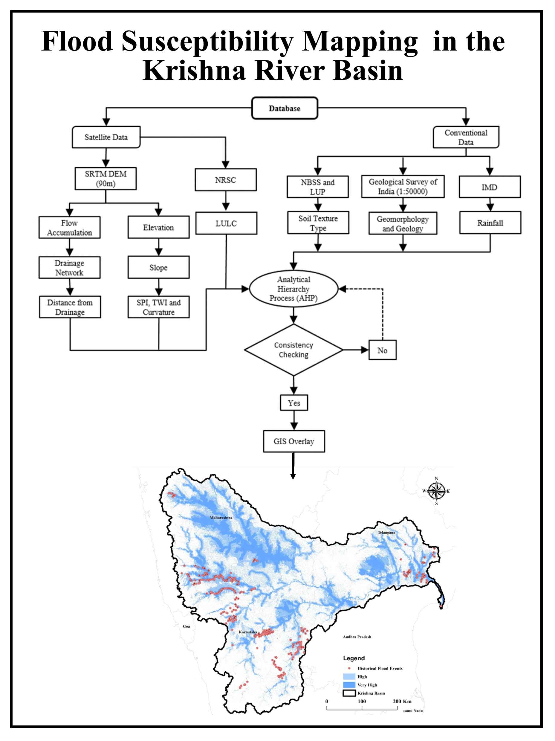
The study integrates 13 physiographic parameters in ArcGIS using a multi-criteria AHP, validated by a high consistency ratio (CR = 0.04).
It classifies the Krishna River Basin into five susceptibility zones, revealing that 38% of the area falls into the high and very high-risk categories.
High flood risk is strongly correlated with low-lying floodplains, clay-loam soils, dense drainage networks, and built-up-agricultural land use.
The model demonstrates robust predictive capability, achieving 79% accuracy when validated using the Area Under the Curve (AUC) method.
The findings identify approximately 30 major cities at risk, offering actionable insights for prioritizing mitigation, land-use zoning, and flood management.
Chattaraj, D., Paul, B. and Sarkar, S., 2021. Integrated multi-parametric analytic hierarchy process (AHP) and geographic information system (GIS) based spatial modelling for flood and water logging susceptibility mapping: A case study of English Bazar Municipality of Malda, West Bengal, India. Natural Hazards and Earth System Sciences Discussions, 1–20.
Chen, W., Panahi, M. and Pourghasemi, H. R., 2017. Performance evaluation of GIS-based new ensemble data mining techniques of adaptive neuro-fuzzy inference system (ANFIS) with genetic algorithm (GA), differential evolution (DE) and particle swarm optimization (PSO) for landslide spatial modelling. Catena, 157, 310–324.
Gaikwad, V. P., 2019. Assessment of morphometric characteristics and demarcation of ground water potential zones using geo spatial technique for vel and sal watershed, India. Unpublished M.Sc. thesis, Department of Geography, Savitribai Phule Pune University.
Krishna River Basin Report, Central Water Commission (CWC) and National Remote Sensing Centre (NRSC), Indian Space Research Organisation (ISRO), 2014. Government of India Report (2.0), 1–180.
Miguez, M. G. and de Magalhaes, L. P. C., 2010. Urban flood control, simulation and management–an integrated approach. In Methods and Techniques in Urban Engineering (131–160).
Patil, A. S., Teli, S. S., Drakshe, P. P., Patil, P. A., Kadam, A. D., Powar, G. P. and Panhalkar, S. S., 2024. Comparative analysis of machine learning, statistical and MCDA methods for rainfall-induced landslide susceptibility mapping in the eco-sensitive Koyna River basin of India. Indian Geotechnical Journal, 1–26.
Ward, R. C. and Robinson, M., 1975. Principles of Hydrology (367). McGraw-Hill.