

Hydrospatial Analysis Volume 5 (2021), Issue 1 · pp. 24-33
Original Research Paper Open Access

Groundwater Potentiality Mapping in Viruthachalam Taluk, Tamil Nadu, India: AHP and GIS Approaches
- Department of Geology, College of Natural and Computational Sciences, Debre Berhan University, Debre Berhan, Ethiopia.
- Department of Earth Sciences, Annamalai University, Annamalainagar - 608 002, India
- Department of Geography and Environmental Sciences, CSSH, Adigrat University, Ethiopia.
- Department of Geology, College of Natural and Computational Sciences, Adigrat University, Ethiopia.
* Corresponding author: Murugesan Bagyaraj, geobagya25@gmail.com
Contents
Highlights
- GIS and Remote sensing technology with AHP approach was used to locate a prospective groundwater areas.
- Inverse Distance Weightage (IDW) technique was used to determine the groundwater potential precinct.
- An excellent possible groundwater zone for patches in the northern and central sections of Kotteri and Kammapuram in Virudhachalam Taluk.
- The mechanism is suggesting groundwater potential zones for expansion and groundwater control.
Abstract
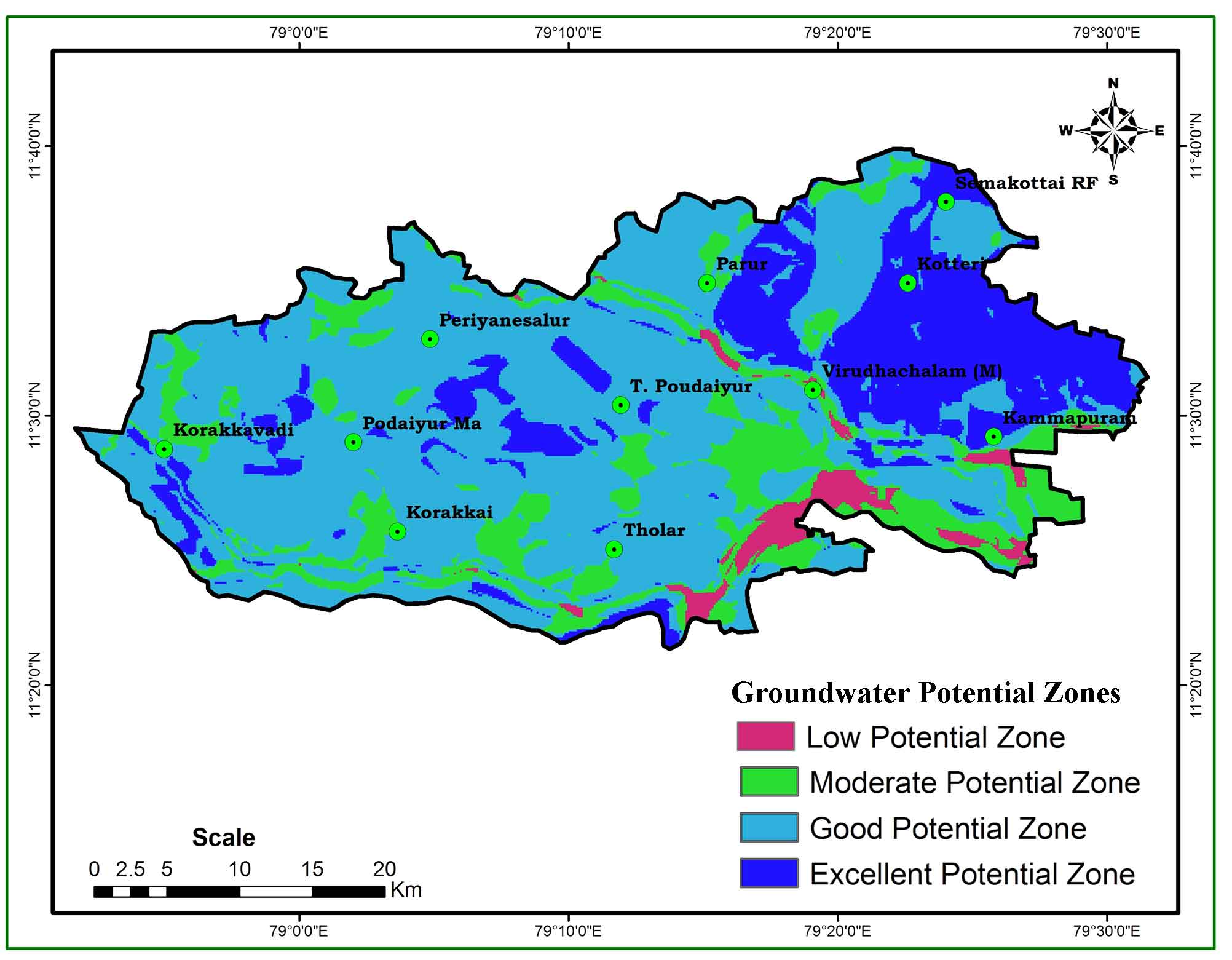
Groundwater is the most valuable treasury commodity in the world, yet it is depleted on a daily basis. Hand arrangement is crucial in assembly for delineating a potential groundwater zones. Geographic Information System (GIS) and Remote Sensing (RS) data with Analytical Hierarchy Process (AHP) approach have proven critical for micro level analysis of groundwater potentials. This exploration was authorized in order to locate a prospective groundwater area in the Virutachalam Taluk of Southern India. The Inverse Distance Weightage (IDW) technique was used to determine the groundwater potential precinct by thematic layers of drainage, drainage density, geology, lineament, lineament density, geomorphology, soil, and slopes. Overall, the prospective groundwater zone in the study area was classified as excellent (20.66 %), good (60.29 %), moderate (16.38 %) and poor (2.73 %). This optional analysis offers an excellent possible groundwater zone for patches in the northern and central sections of Kotteri and Kammapuram in Virudhachalam Taluk. The survey revealed that the approach of inverse distance weighting provides an operating mechanism for suggesting groundwater potential zones for clear expansion and groundwater control in not the same hydro-geological settings.
Keywords Remote SensingPotential AreaIDW GroundwaterGISAHP
1. Introduction
The scarcity and domination of water supply in India’s pastoral and urban regions have been impacted by fast industrial expansion, rehabilitation, and population increase. The discovery of the aquifer and the virtuous eminence of water demand an extraordinary priority for ground water numerical assessment (Oh et al., 2011). Conversely, the calculation of groundwater yield was not deliberate in hydrological education. The Geographic Information System (GIS) and Remote Sensing Strategies have an infinite number of applications in hydrological research in this sector. GIS is expressed as the greatest expertise in the arrangement of spatial data and the verdict of countless geographical, hydrological and eco-friendly sciences (Goodchild, 1993; Brunner et al., 2004; Chowdhury et al., 2009; Oh et al., 2011; Rahmati et al., 2014). This main strategy is a hasty and budget real method to manufacture bellowed data from a variety of geological strata that can be used in a cracking the groundwater possible zones. One of the most important parts of the gene is the relationship between slopes, land usage, land curves, and lineaments, which is represented by the Remote Sensing (RS) techniques. These stats can be given as a function in the GIS and overplayed with former statistics (Hinton, 1996; Jha et al., 2007). Several GIS and RS researchers are concentrating on the empathy of latent groundwater areas utilizing several thematic strata such as geology, geomorphology, drainage, drainage density, lineament, soil, and lithology (Gnanachandrasamy et al., 2018; Ganapuram et al., 2009; Magesh et al., 2012; Nagarajan et al., 2009; Chowdhury et al., 2009; Solomon and Quiel, 2006; Prasad et al., 2008; Saha et al., 2010; Kumar et al., 2016; Muralitharan et al., 2015; Yeh et al., 2016). Currently, satellite data are commonly ignored in order to include baseline records of the groundwater potential region (Thomas et al., 1999; Chowdhury et al., 2010; Harinarayana et al., 2000). This modus operandi bounces through a wide range of almost ground-level clarifications (Murthy, 2000; Leblanc et al., 2003; Tweed et al., 2007).
The properties of groundwater are connected to those of the surface (e.g. surface water and soil water). Thus, by extracting important information on surface characteristics from remote sensing pictures, relevant information on groundwater may be obtained (Amineha et al., 2017; Rahmati et al., 2015). Geographic Information System, (GIS) technologies have been widely employed in water science due to its capacity to generate spatial information as well as their practicality in spatial data analysis and prediction (Kanagaraj et al., 2019; Jha et al., 2010). A variety of studies have been conducted to evaluate potential groundwater regions using GIS and Remote Sensing (Madani et al., 2015; Deepika et al., 2013). Experiment factor analysis was used extensively in many of the experiments, which combined several theme layers (e.g., topography, geomorphology, geology, ground cover / land use (LULC), hydrology, and vegetation) with GIS methods (Alfred et al., 2018). To produce the necessary theme layers, a range of remote sensing and image processing techniques were frequently employed in these investigations. To produce thematic layers, these investigations frequently employ a variety of imaging methods. In addition, thematic layers are created using field-collected material, databases, and current maps. Most academics rely on empiricist principles and reference papers in diverse articles on groundwater capacity to determine and assign weight values to thematic layers (Kumar and Krishna, 2016; Madani and Niyazi, 2015; Patra et al., 2018). However, in this study, a change in the research field might result in an incorrect classification and the classification number, as well as an incorrect weight distribution. Human factors might contribute to errors in the final result. To avoid this error, each subject layer has defined dimensions. At the same time, this study changes by Li et al. (2010) standards formula. In order to more intuitively observe the uniform layers.
Tomas Saaty created the AHP in 1980 as a useful method for dealing with complicated decision making in groundwater related disciplines. The technique is effective for breaking down complicated decisions into a series of pairwise comparisons and then synthesizing the outcomes. Furthermore, the AHP tool is an appropriate approach for analyzing the consistency of the outcome, therefore, eliminating bias in the decision-making process (Saaty, 1990). In the Southern, Western Ghats of India, a combination of geographical information system and analytical hierarchical process techniques (AHP) was recently employed. A total of 12 thematic layers was created and investigated for groundwater potential zone delineation, including geology, geomorphology, land use/land cover, lineament density, drainage density, rainfall, soil, slope, roughness, topographic wetness index, topographic position index, and curvature (Arulbalaji et al., 2019; Ahmadi et al., 2021).
A variety of reports have addressed the method for evaluating possible groundwater zones (Mohammadi-Behzad et al., 2019; Roy et al., 2019; Amineha et al., 2017). Among them, many researchers used the AHP approach in their papers and obtained strong results (Singh et al., 2018; Verma et al., 2020; Khashei-Siuki et al., 2020). Garden-fresh water holdings of India are mostly sprayed. Throughout the rainy season and varying physiological factors, elasticity rises to an uneven sharing of water. Owing to the inordinate period of time, population increase, sprawl and agronomic enlargement have exacerbated the location. Natural mistreatment of freshwater is a significant source of water starvation. Flat now, certain areas of the world are pebbledash of dire water calamity. Quite apart from the creature’s right vital quantity of the nation’s increase, the analysis of the water store was patchy. The key goal of this analysis is therefore to demarcate the future groundwater region in Viruthachalam Taluk from the southern part of India, which is an exhausting assimilation of the geographical information system and remote sensing with AHP approach.
2. Study Area
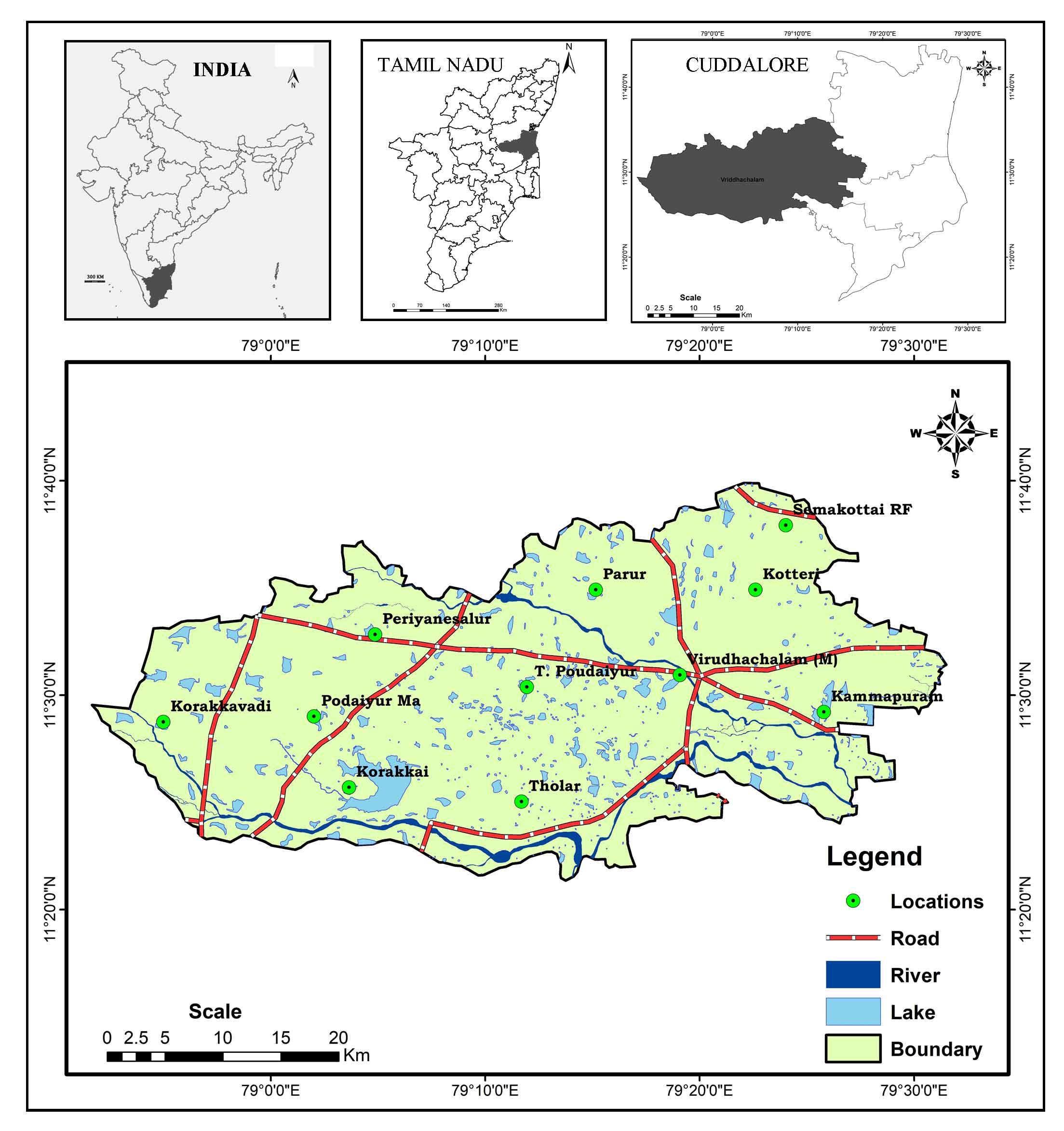
Viruthachalam Taluk, Thirumudhukundram was the town’s ancient name (Figure 1). It has a land size of 1,485.33 km2 and is located in the Indian state of Tamil Nadu. It is situated between 79° 0' and 79° 30' E longitude, 11°40' and 11°20' N latitude (Toposheet numbers 58M/10 and M58/14). Thirumanimutharu is the major river. The environment is hot and dry, with a low temperature of 19.5 °C and a maximum temperature of 39.8 °C in May and June. With an annual rainfall of 825.6 mm, rainfall peaks from November to December, underneath the Northeast monsoon. Deep red laterite soil and deep black cotton soil are the most common soil types. Hard rock terrain has red soil, limestone zones have black soil, while sandstone and Cuddalore sandstone have deep red laterite soil. The Viruthachalam Taluk is geomorphologically split by pediplains and uplands, pediplain with gentle slope lands. The drainage density is typically moderate.
3. Materials And Methods
The foundation of a base map using Survey of India Toposheet completes the identification of a probable groundwater zone. Aiming to prepare a base map, Arc map 10.2 was utilized, together with spatial research tools from the IDW weightage approach. Furthermore, geology, drainage depth, geomorphology, slope, surface, and linear depth maps were created using various state surface and land use survey cradles, the Public Works Department (PWD), the Tamil Nadu Water Supply and Drainage Board (TWAD)-GIS section, satellite imagery (IRS-1C, LISS-III, and SRTM data, and ERDAS at a scale of 1:50,000. Third, every thematic stratum categorized into various sorts and meant as classes (Table 1). Each thematic layer was ranked on the basis of its essential association groundwater funds. Influences and weighting of veneration attributed to groundwater capacity. After that, the pair-wise valuation matrix was produced using a ranking approach for computing regulated inverse distance, weights (IDW) for all thematic layers and their geographies. To begin the potential groundwater area, all theme layers were layered. To calculate the groundwater potential index, the following equation was used to calculate the overall weights of distinct polygons in the combined layer (Rao and Briz-Kishore, 1991):
GWPI = ((GMw)(GMwi) + (GGw)(GGwi) + (DDw)(DDwi) + (LDw) (LDwi) + (SLw)(SLwi) + (STw)(STwi))
where GWPI denotes the groundwater potential index, GM denotes geomorphology, GG denotes geology, DD denotes drainage density, LD denotes line density, SL denotes slope, and ST denotes soil type, and the subscripts “w” and “wi” denote the normalized weights of layer and normalized weights in each thematic layer, respectively.
Table 1. Thematic layers with class influences and weighting
|
Parameters |
Classes |
Influences |
Weightages |
|
Geology |
Alluvium Recent |
10 |
1 |
|
Anorthosite (Basic rocks) |
1 |
||
|
Clay (Reddish Brown) |
1 |
||
|
Cuddalore Sand stone |
3 |
||
|
Granite (Gr2) |
2 |
||
|
Granitoid gneiss |
1 |
||
|
Quartz vein |
1 |
||
|
Sand and silt |
2 |
||
|
Sand stone |
3 |
||
|
Geomorphology units |
Alluvial Plain |
20 |
1 |
|
Pediment |
3 |
||
|
Flood Plain |
1 |
||
|
Upland |
2 |
||
|
Slope |
Gentile slope |
35 |
3 |
|
Moderate slope |
2 |
||
|
Steep slope |
1 |
||
|
Lineament density |
Low |
30 |
0 |
|
Moderate |
1 |
||
|
High |
2 |
||
|
Drainage density |
Low |
5 |
3 |
|
Moderate |
2 |
||
|
High |
1 |
||
|
Soils |
Deep red and laterite soils |
25 |
3 |
|
Young river alluvium soils |
1 |
||
|
Moderately deep red, laterite and black soils |
2 |
||
|
Red Soils |
3 |
||
|
Black Soils |
2 |
||
|
Deep black cotton soils |
2 |
4. Results And Discussion
4.1 Geology
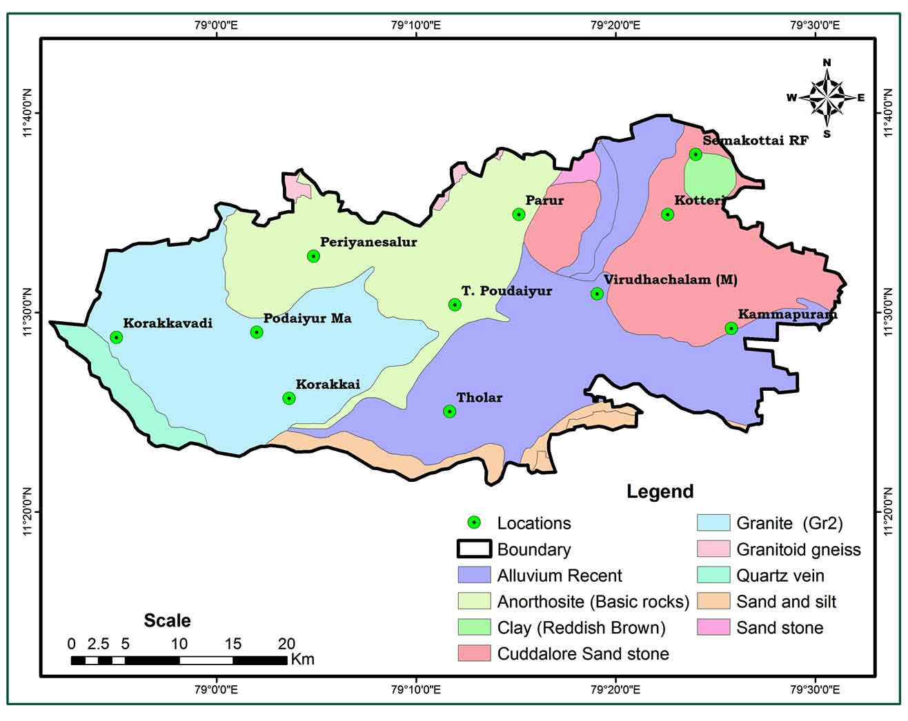
The geological map (Figure 2) was created using Arc GIS tools and a substantial number of geological arrangements that were visible and plotted with appropriate symbols. The lithological sections are Alluvial recent S-E and sandstone, Cuddal sandstone-NE, Clay (reddish brown) S-W, sand, silt and mixed with Granitiod gneiss N-W, Anorthosite (basic rocks) and granite (gr2). At the start of their water holding assets, a separable geological layer is unglued and weighted. Sandstone with clay, Cuddalore sandstone with sand, silt and clay are regarded as probable water demeanors, and therefore the highest rating was provided. This rock kind is found in the largest section of the sample region.
4.2 Geomorphology
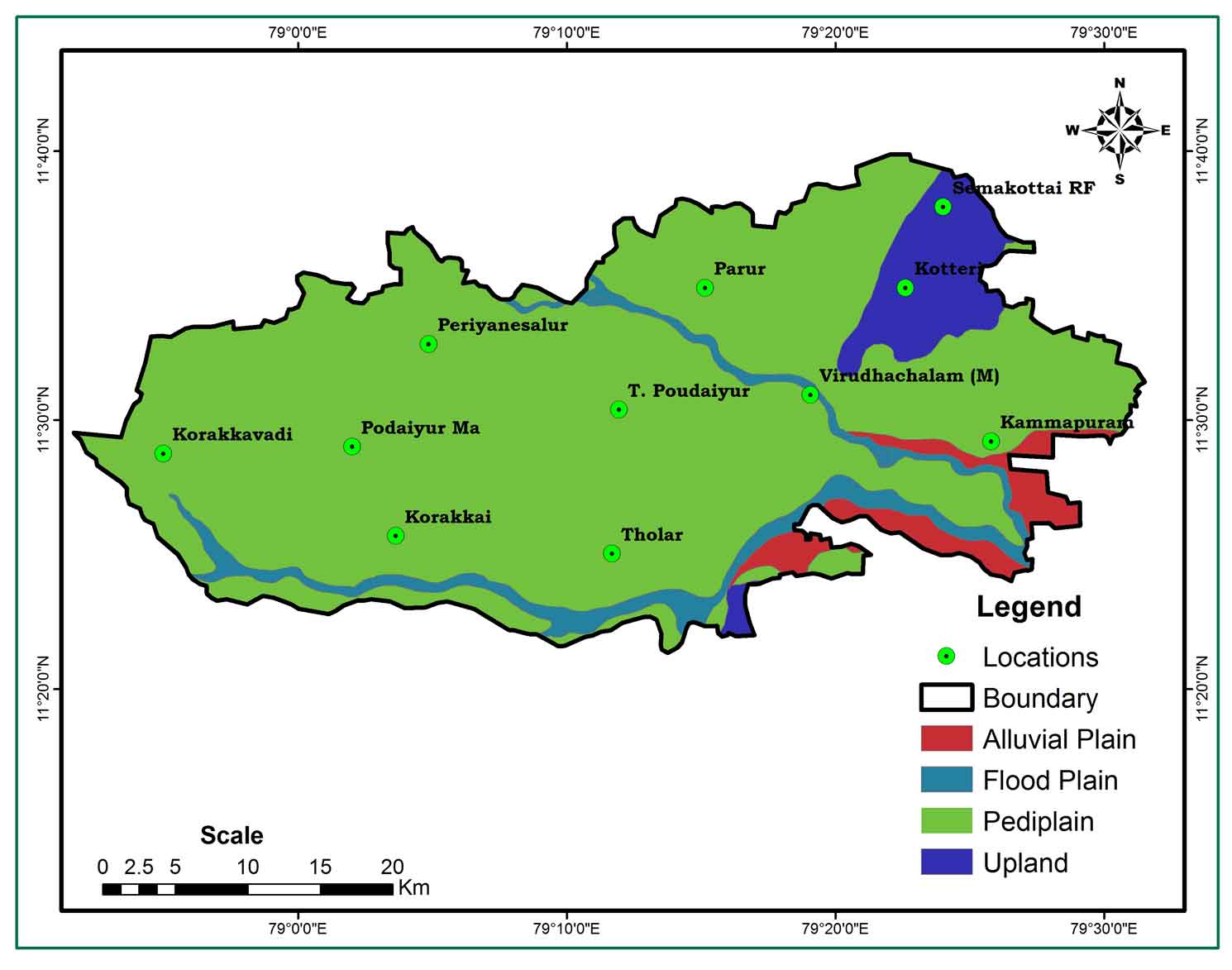
Using visual clarity techniques, a geomorphological map (Figure 3) of the research region LISS-III satellite data was created. It is split into four layers: pediplain, flood plain upland, alluvial plain, and alluvial plain. A major section of the sample region is made up of pediplains intersected by flood plains, highlands, and alluvial plains. Keeping capability rating is assigned to all strata based on land types and water.
4.3 Drainage and Drainage Density
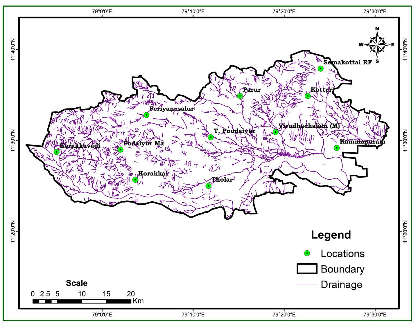
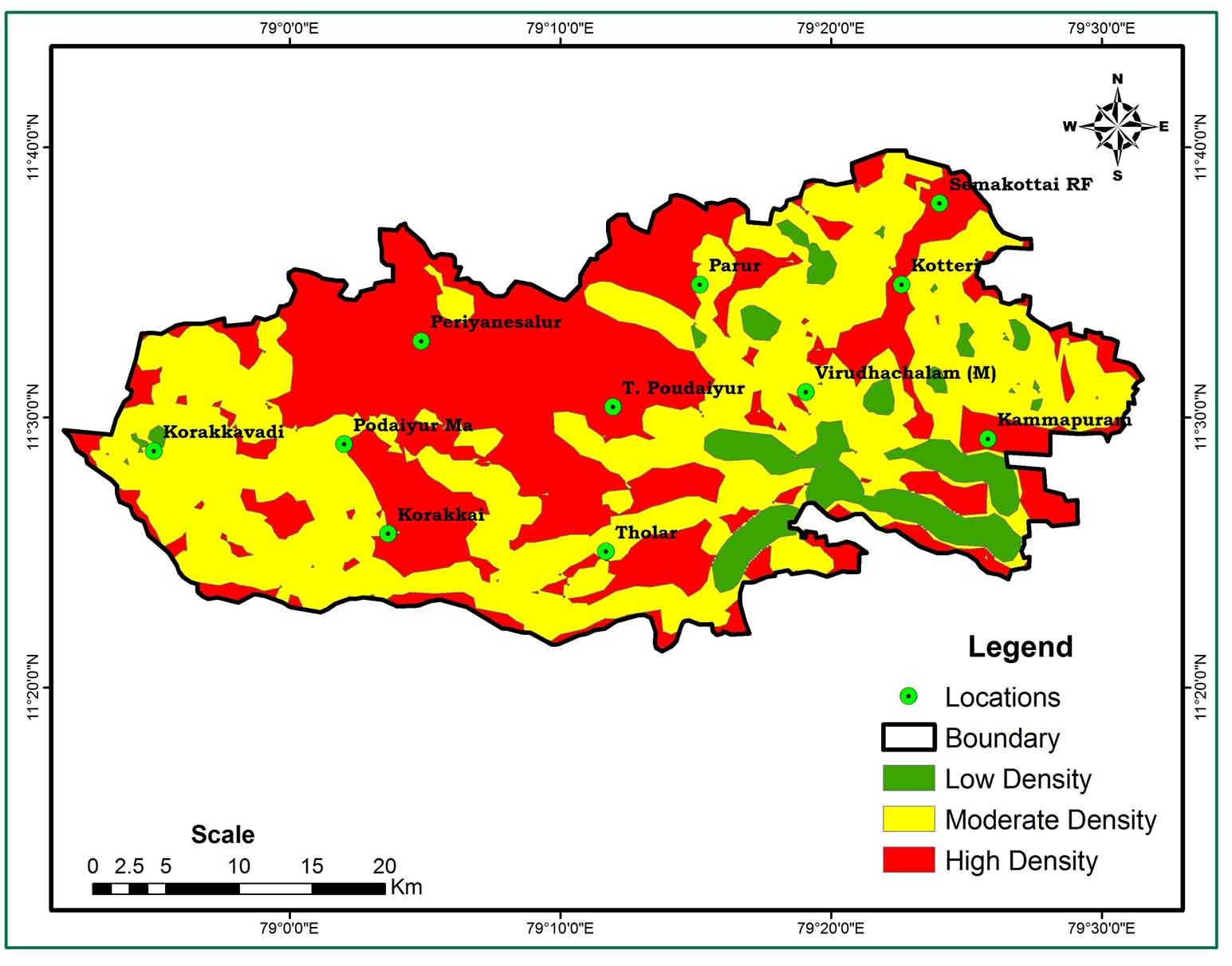
Drainage pattern in every territory shows the characteristics of both ground and underground formations. The underlying lithology recognizes this function, which provides an essential signal of the water purification rate (Shaban et al., 2006). The drainage pattern (Figure 4) is mostly dendritic, but the drainage density (Figure 5) is the sum of all tributaries that determine the distance per unit of drainage area (km / km2) and the canals’ contiguousness (Horton, 1932). The drainage density of the area is classified into three groups in the analysis, ranging from extremely low (1) to very high (> 6). The region with the lowest drainage density received the highest score, while places with the most drainage capacity received the lowest ranking. Mostly scattered across the research area of moderate density and partially filled, the higher drainage density at Kotteri, T. Poudaiyur, Periyanesalur, lower drainage density in the N-W portion of the study district.
4.4 Lineaments and Lineament Density
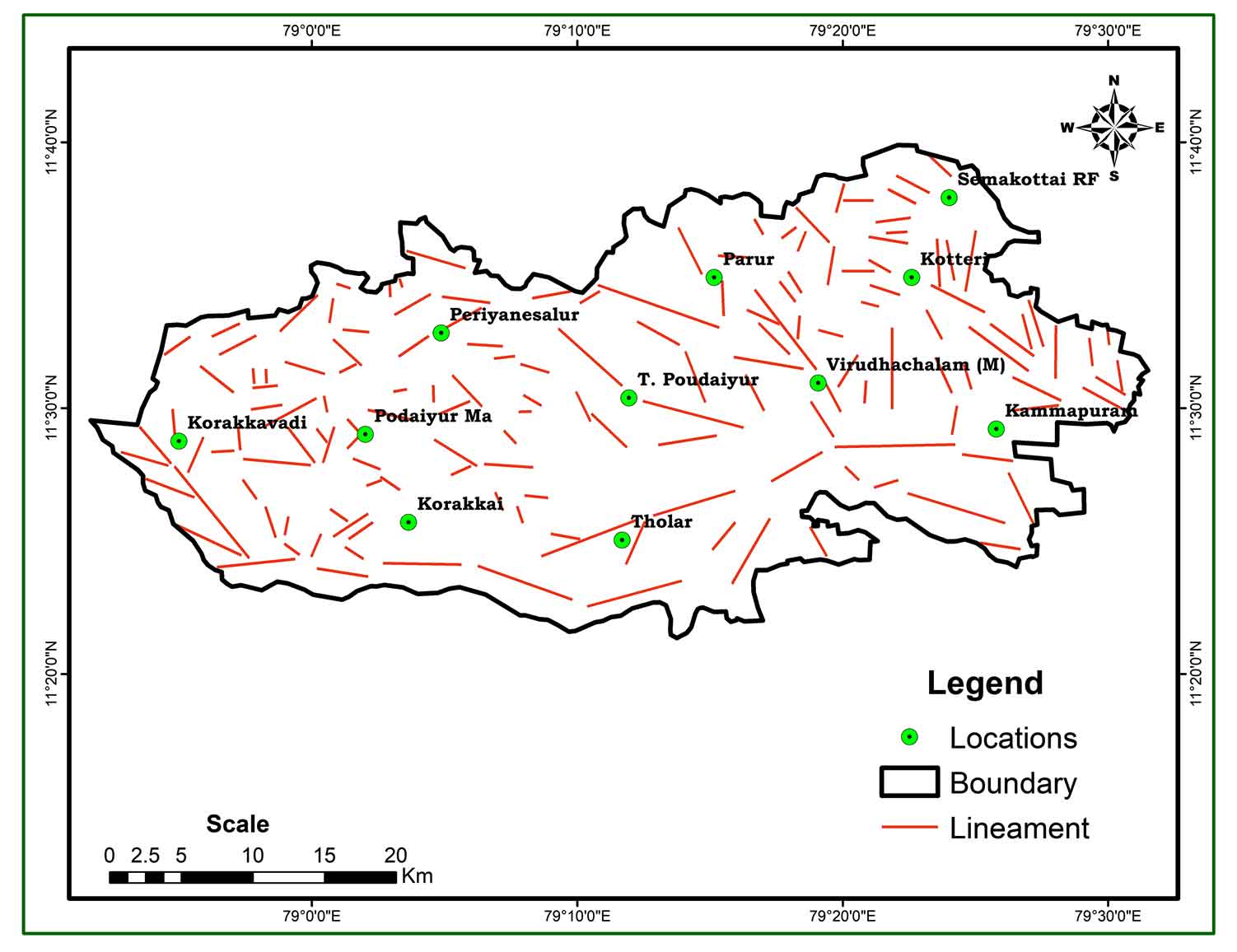
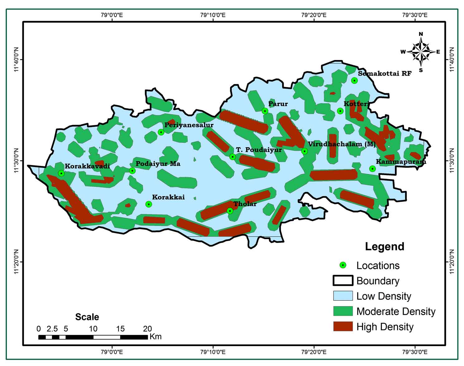
The presence of lineaments (Figure 6) usually indicates a porous zone, and a high lineament density (Figure 7) indicates a large groundwater capacity (Haridas et al., 1998; Ghosh et al., 2016; Magesh et al., 2012). Linear density is classified into three categories: high, medium, and low. With a high ranking of 2, the center of the study area, N-S-W, and the southern half of the research region have significant lineament density.
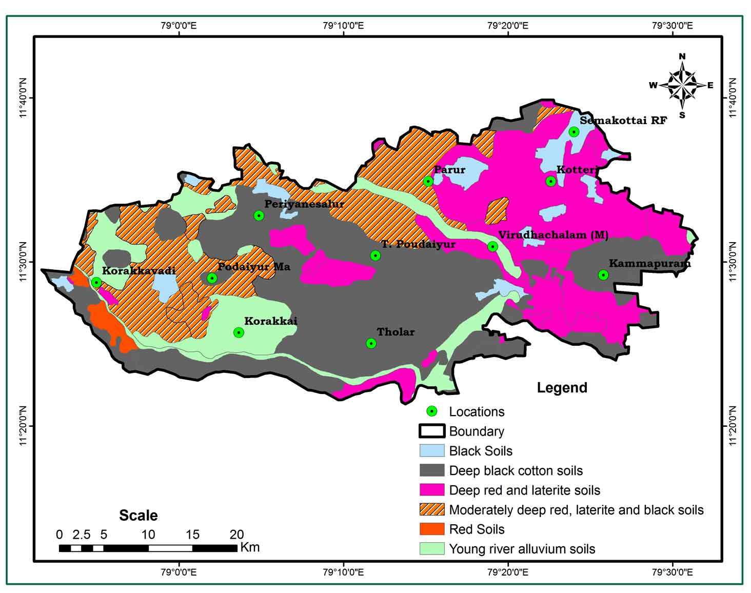
4.5 Soil
Soil (Figure 8) is also a significant factor in determining the potential groundwater region (Kumar et al., 2016). Black soils, deep black cotton soils, deep red and laterite soils, comparatively deep red laterite and black soils, red soils, and young river alluvium soils were the six types of soil described and graded. Each soil group is weighted on the basis of its characteristics correlated with groundwater. Deep red and laterite soils with a grade of 3 in the northeast and southwestern portions of the area are regarded to have a very excellent potential based on the quantity of intrusion and groundwater potential. Black soils, particularly deep black cotton soils, have a moderate to low potential (Malik et al., 2010) and have been classified as 2 and young river alluvium soils of poor potential and ranked 1.
4.6 Slope
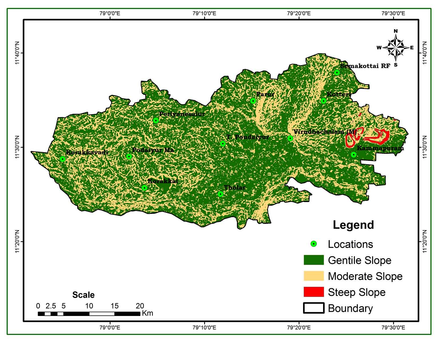
Based on the gradation of the slope, the field is graded as gentle, moderately deep, moderate and steep (Figure 9). Slight slopes are considered to be strong prospects and the top rating 3 has been assigned. In the case of steep slopes with a high surface runoff, it is well-considered that weak groundwater capacity with the lowest rating 1 has been allocated.
5. Demarcation Of Potential Groundwater Zone
The groundwater potential zone map was created by using weighted overlay techniques in the IDW spatial analysis method to overlay the accumulative weight given to all thematic layers (geology, geomorphology, drainage density, lineament density, soil, and slope). Each theme layer was divided by grading and weighting in the weighted overlay discovery method based on its water hold. Appropriately, higher and lower weights have been assigned to higher and lower groundwater capacity. The rating and weighting of each stratum are further allocated and the quantity obtained in the future groundwater region. All layers have been rehabilitated and overlaid to the raster style. The research region was categorized into four groups based on weighted overlay analysis: Excellent Potential Zone (20.66%), Good Potential Zone (60.29%), Moderate Potential Zone (16.38%) and Low Potential Zone (2.73 %). Result reveals that the majority of the area classified as Excellent Potential Zone (306.89 km2), Good Potential Zone (894.54km2) followed by Moderate (243.32km2), and Low Potential Zone (40.58 km2). Excellent possible groundwater zone existed in patches in the northern and central parts of Kotteri, Vridhachalam, Kammapuram and Parur, owing to sandstone and cuddalore sandstone and the strong penetration of groundwater by the red laterite. Furthermore, by improving the quality and geographical resolution of the data, the conclusions of this study may be enhanced. The potential region of the groundwater map is depicted in figure 10.
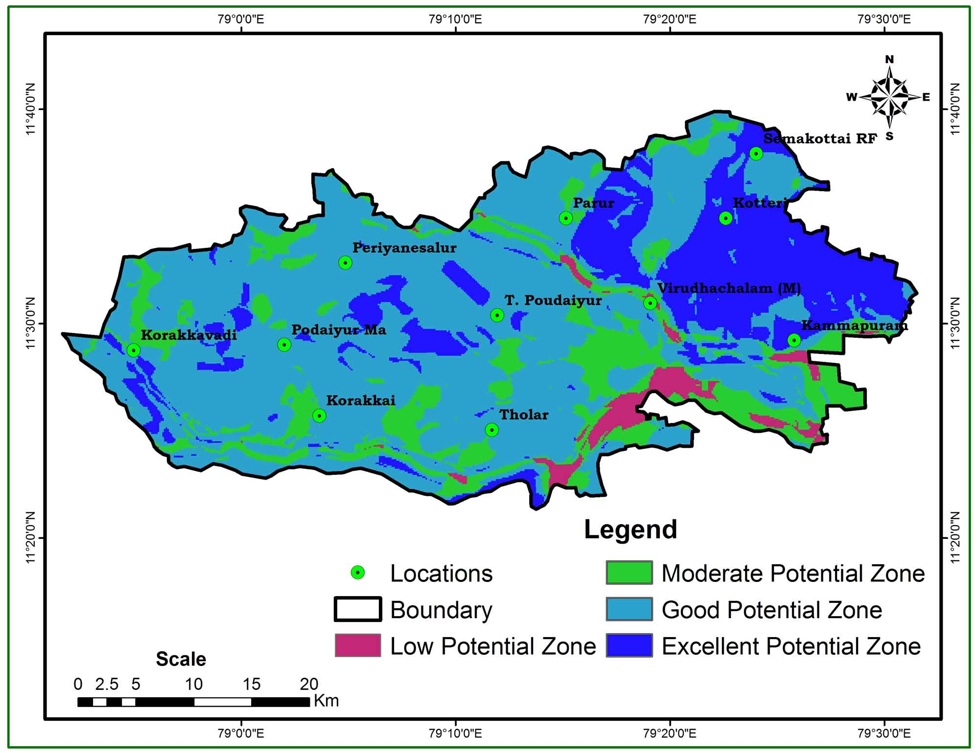
Table 2. Groundwater Potential Zones
|
Zones |
Area |
|
|
km2 |
% |
|
|
Low Potential Zone |
040.58 km2 |
02.73 |
|
Moderate Potential Zone |
243.32 km2 |
16.38 |
|
Good Potential Zone |
894.54 km2 |
60.29 |
|
Excellent Potential Zone |
306.89 km2 |
20.66 |
6. Conclusion
The present study focused on a probabilistic approach that used both GIS and RS satellite imageries to find the potential groundwater zones in Viruthachalam taluk. Various thematic layers such as geomorphology, geology, irrigation, irrigation depth, lineaments, lineament density, slope and soil maps have been prepared from satellite data using GIS and ERDAS tools to identify the possible groundwater region of the city in order to identify the potential groundwater region. Based on the combined weighted thematic charts, the Virudhachalam Taluk groundwater potential region is classified as good (60.29%), moderate (16.38%), excellent (20.66%) and low (2.73%). These GIS and RS techniques have shown that there is a very good potential groundwater zone in the northern and central areas of Virdhachalam and Kotteri. While there was a good potential groundwater zone in the North, South and Northwest of the study area. This research is very useful for the public and government sectors to know the possible groundwater region for environmental protection and use of this Taluk.
Conflict of interest
The authors declare that there are no conflicts of interest.
Acknowledgements
The authors would like to thank NRSC, Hyderabad and Public work department, Tamil Nadu for providing necessary data to conduct research work. We would like to thank the editor and anonymous reviewers for their critical and constructive comments of the manuscript.
Abbreviations
AHP: Analytical Hierarchical Process; DD: Drainage Density; ERDAS: Eastern Range Dispersion Assessment System; GG: Geology; GIS: Geographic Information System; GM: Geomorphology; GWPI: Ground Water Potential Index; IDW: Inverse Distance Weightage; LD: Lineament Density; LISS: Linear Imaging Self Scanning; LULC: Land Use Land Cover; NE: North East; NRSC: National Remote Sensing Centre; NW: North West; PWD: Public Works Department; RS: Remote Sensing; SL: Slope; SRTM: Shuttle Radar Topography Mission; ST: Soil Type; SW: South West; TWAD: Tamil Nadu Water Supply and Drainage Board.
Article information
- Received
- 7 May 2021
- Revised
- 18 Jun 2021
- Accepted
- 19 Jun 2021
- Published
- 20 Jun 2021
- Handling editor
- Dr. Pramodkumar Hire
- Licence
- CC BY-NC-ND 4.0
- Journal
- Hydrospatial Analysis, ISSN 2582-2969
References
-
Ahmadi, H., Kaya, O.A., Babadagi, E., Savas, T. and Pekkan, E., 2021. GIS-Based groundwater potentiality mapping using AHP and FR models in Central Antalya, Turkey. Environ. Sci. Proc. 5, 11.
Crossref -
Alfred, M., Webster, G., Zvikomborero, H., 2018. An assessment of groundwater potential and vulnerability in the Upper Manyame Sub-Catchment of Zimbabwe. Physics and Chemistry of the Earth, Parts A/B/C, 105, 72-83.
Crossref -
Amineha, Z. B. A., Al-DinHashemian S.J., Magholic A., 2017. Integrating Spatial Multi Criteria Decision Making (SMCDM) with Geographic Information Systems (GIS) for delineation of the most suitable areas for aquifer storage and recovery (ASR). Journal of Hydrology, 551, 577-595.
Crossref -
Arulbalaji, P., Padmalal, D. and Sreelash, K., 2019. Delineation of groundwater potential zones: A case study from southern Western Ghats, India. Scientific Reports, 9, 2082.
Crossref -
Bagyaraj, M., Ramkumar, T., Venkatramanan, S. and Gurugnanam, B., 2013. Application of remote sensing and GIS analysis for identifying groundwater potential zone in parts of Kodaikanal Taluk, South India. Front. Earth Sci., 7(1), 65-75.
Crossref -
Brunner, P., Bauer, P., Eugster, M. and Kinzelbach, W., 2004. Using remote sensing to regionalize local rainfall recharge rates obtained from the chloride method. Jour. Hydrol., 294(4), 241-250.
Crossref -
Chowdhury, A., Jha, M. K. and Chowdary, V. M., 2010. Delineation of groundwater recharge zones and identification of artificial recharge sites in West Medinipur district, West Bengal, using RS, GIS and MCDM techniques. Environ. Earth Science, 59(1), 1209-1222.
Crossref -
Chowdhury, A., Jha, M. K., Chowdary, V. M and Mal, B. C., 2009. Integrated remote sensing and GIS-based approach for assessing groundwater potential in west medinipur district, west Bengal, India. Internat. Jour. Remote Sens., 30(1), 231-250.
Crossref -
Deepika, B., Avinash, K., Jayappa, K., 2013. Integration of hydrological factors and demarcation of groundwater prospect zones: insights from remote sensing and GIS techniques. Environment Earth Science, 70, 1319-1338.
Crossref -
Ganapuram, S., Vijaya Kumar, G. T., Murali Krishna, I. V., Kahya, E. and Cuneyd Demirel, M., 2009. Mapping of groundwater potential zones in the Musi basin using remote sensing data and GIS. Adv. Engg. Software, 40(1), 506-518.
Crossref -
Ghosh, P. K., Bandyopadhyay, S. and Jana, N. C., 2016. Mapping of groundwater potential zones in hard rock terrain using geoinformatics: A case of Kumari watershed in western part of West Bengal. Model. Earth Syst. Environ., 2.
Crossref -
Gnanachandrasamy, G. Yongzhang Zhou, Bagyaraj, M., Venkatramanan, S., Ramkumar, T., Wang, S., 2018. Remote sensing and GIS based groundwater potential zone mapping in Ariyalur District, Tamil Nadu. Journal Geological Society of India, 92, 484-490.
Crossref -
Goodchild, M. F., 1993. The state of GIS for environmental problem solving. In: Goodchild M. F., Parks B. O., Steyaert L. T. (Ed.) Environmental modeling with GIS. Oxford University Press, New York, 8-15.
-
Haridas, V. R., Aravindan, S. and Girish, G., 1998. Remote sensing and its applications for groundwater favourable area identiûcation. Quart. Jour. GARC, 6, 18-22.
-
Harinarayana, P., Gopalakrishna, G. S. and Balasubramanian, A., 2000. Remote sensing data for groundwater development and management in Keralapura watersheds of Cauvery basin, Karnataka, India. Indian Mineralogists, 34, 11-17.
-
Hinton, J. C., 1996. GIS and remote sensing integration for environmental applications. Geographical Information Systems, 10(7), 877-890.
Crossref -
Horton, E., 1932. Drainage-basin characteristics. Eos, Transactions American Geophysical Union, 13(1), 350-361.
Crossref -
Jha, M. K., Chowdary, V. M. and Chowdhury, A., 2010. Groundwater assessment in Salboni Block, West Bengal (India) using remote sensing, geographical information system and multi-criteria decision analysis techniques. Journal of Hydrology, 18, 1713-1728.
Crossref -
Jha, M. K., Chowdhury, A., Chowdary, V. M. and Peiffer, S., 2007. Groundwater management and development by integrated remote sensing and geographic information systems: Prospects and constraints. Water Resour. Managmt., 21(2), 427-467.
Crossref -
Kanagaraj, G., Suganthi, S., Elango, L. and Magesh, N. S., 2019. Assessment of groundwater potential zones in Vellore district, Tamil Nadu, India using geospatial techniques. Earth Science Informatics, 12, 211-223.
Crossref -
Khashei-Siuki, A., Keshavarz, A. and Sharifan, H., 2020. Comparison of AHP and FAHP methods in determining suitable areas for drinking water harvesting in Birjand aquifer, Iran. Groundwater for Sustainable Development, 10, 100328.
Crossref -
Koike, K., Nagano, S. and Ohmi, M., 1998. Lineament analysis of satellite images using a segment tracing algorithm (STA). Computers and Geosciences, 21(9), 1091-1104.
Crossref -
Kumar, A. and Krishna, A. P., 2016. Assessment of groundwater potential zones in coal mining impacted hard-rock terrain of India by integrating geospatial and analytic hierarchy process (AHP) approach. Geocarto International, 1-25.
Crossref - Crossref
-
Leblanc, M., Leduc, C., Razack, M., Lemoalle, J., Dagorne, D. and Mofor, L., 2003. Application of remote sensing and GIS for groundwater modeling of large semiarid areas: example of the Lake Chad Basin, Africa. In: Hydrology of Mediterranean and Semiarid Regions Conference, Montpieller, France. Red Books Series, 278. IAHS, Wallingford, 186192.
-
Madani, A. and Niyazi, B., 2015. Groundwater potential mapping using remote sensing techniques and weights of evidence GIS model: A case study from Wadi Yalamlam basin, Makkah Province, Western Saudi Arabia. Environment Earth Science, 74(6), 5129-5142.
Crossref -
Magesh, N. S., Chandrasekar, N. and Soundranayagam, J. P., 2012. Delineation of groundwater potential zones in Theni district, Tamil Nadu, using remote sensing, GIS and MIF techniques. Geoscience Frontiers, 3(2), 189-196.
Crossref -
Malik, M. I., Bhat, M., S. and Najar, S. A., 2016. Remote Sensing and GIS Based groundwater potential mapping for sustainable water resource management of lidder catchment in Kashmir Valley, India. Jour. Geol. Soc. India, 87, 716-726.
Crossref -
Mohammadi-Behzad, H. R., Charchi, A., Kalantari, N., Nejad A. M. and Vardanjani, H. K., 2019. Delineation of groundwater potential zones using remote sensing (RS), geographical information system (GIS) and analytic hierarchy process (AHP) techniques: a case study in the Leylia-Keynow watershed, southwest of Iran. Carbonates and Evaporites, 34, 1307-1319.
Crossref -
Muralitharan, J. and Palanivel, K., 2015. Groundwater targeting using remote sensing, geographical information system and analytical hierarchy process method in hard rock aquifer system, Karur district, Tamil Nadu, India. Earth Sci. Inform., 8827-842.
Crossref -
Murthy, K. S. R., 2000. Groundwater potential in a semi-arid region of Andhra Pradesh: Geographical information system approach. Internat. Jour. Remote Sensing, 21, 1867-1884.
Crossref -
Nagarajan, M. and Singh, S., 2009. Assessment of groundwater potential zones using GIS technique. Jour. Indian Soc. Remote Sens., 37, 69-77.
Crossref -
Oh, H.-J., Kim, Y.-S., Choi, J.-K., Park, E. and Lee, S., 2011. GIS mapping of regional probabilistic groundwater potential in the area of Pohang City, Korea. Journal of Hydrology, 399(1), 158-172.
Crossref -
Patra, S., Mishra, P. and Mahapatra, S. C., 2018. Delineation of groundwater potential zone for sustainable development: A case study from Ganga Alluvial Plain covering Hooghly district of India using remote sensing, geographic information system and analytic hierarchy process. Journal of Cleaner Production, 172, 2485-2502.
Crossref -
Prasad, R. K., Mondal, N. C., Banerjee, P., Nandakumar, M.V. and Singh, V. S., 2008. Deciphering potential groundwater zone in hard rock through the application of GIS. Environ. Geol., 55(3), 467-475.
Crossref -
Rahmati, O., Nazari Samani, A., Mahdavi, M., Pourghasemi, H.R. and Zeinivand, H., 2014. Groundwater potential mapping at Kurdistan region of Iran using analytic hierarchy process and GIS. Arab J Geosci, 8, 7059-7071.
Crossref -
Rahmati, O., Samani, A.N., Mahdavi, M., Pourghasemi, H. R. and Zeinivand, H., 2015. Groundwater potential mapping at Kurdistan region of Iran, using analytic hierarchy process and GIS. Arabian Journal of Geosciences, 8, 7059-7071.
Crossref -
Rao, B. V. and Briz-Kishore, B. H., 1991. A methodology for locating potential aquifers in a typical semi-arid region in India using resistivity and hydrogeologic parameters. Geoexploration, 27, 55-64.
Crossref -
Roy, A., Keesari, T., Sinha, U. K. and Sabarathinam , C., 2019. Delineating groundwater prospect zones in a region with extreme climatic conditions using GIS and remote sensing techniques: A case study from central India. Journal of Earth System Science, 128,201.
Crossref -
Saaty, T. L., 1990. Decision making for leaders: The analytic hierarchy process for decisions in a complex world. RWS publications.
-
Saha, D., Dhar, Y. R., Vittal, S. S., 2010. Delineation of groundwater development potential zones in parts of marginal Ganga alluvial plain in south Bihar, Eastern India. Environ. Monitor., 165 (1- 4), 179-191.
Crossref -
Shaban, A., Khawlie, M. and Abdallah, C., 2006. Use of remote sensing and GIS to determine recharge potential zone: The case of Occidental Lebanon. Hydrogeol. Jour., 14, 433-443.
Crossref -
Singh, A. K. and Prakash, S. R., 2003. An integrated approach of remote sensing, geophysics and GIS to evaluation of groundwater potentiality of Ojhala subwatershed, Mirzapur district, UP, India. Map India conference.
-
Singh, L. K., Jha, M. K. and Chowdary, V.M., 2018. Assessing the accuracy of GIS-based Multi-Criteria Decision Analysis approaches for mapping groundwater potential. Ecological indicators, 91, 24-37.
Crossref -
Solomon, S. and Quiel, F., 2006. Groundwater study using remote sensing and geographic information systems (GIS) in the central highlands of Eritrea. Hydrogeol. Jour., 14, 1029-1041.
Crossref -
Thomas, A., Sharma, P. K., Sharma, M. K and Sood A., 1999. Hydrogeomorphological mapping in assessing groundwater by using remote sensing datada case study in Lehra Gage Block, Sangrur district, Punjab. Jour. Indian Soc. Remote Sensing, 27, 31-42.
-
Tweed, S. O., Leblanc, M., Webb, J. A. and Lubczynski, M. W., 2007. Remote sensing and GIS for mapping groundwater recharge and discharge areas in salinity prone catchments, south eastern Australia. Hydrogeol. Jour., 15, 75-96.
Crossref -
Verma, P., Singh, P. and Srivastava, S. K., 2020. Development of spatial decision-making for groundwater recharge suitability assessment by considering geoinformatics and field data. Arabian Journal of Geosciences, 13, 306.
Crossref -
Yeh, H.-F., Cheng, Y.-S., Lin, H.-I, Le, C.-H., 2016. Mapping groundwater recharge potential zone using a GIS approach in Hualian River, Taiwan. Sustainable Environment Research, 26, 33-43.
Crossref