

Hydrospatial Analysis Volume 6 (2022), Issue 1-2 · pp. 1-12
Original Research Paper Open Access

Spatial Analysis of Groundwater Qualities in Vempalle Mandal of YSR District, Andhra Pradesh, India using Geospatial Techniques
- Krupavathi Chinthala1
- Srinivasa Gowd Somagouni1*
- Ravi Kumar Pappaka1
- Harish Vijay Gudala1
- Pradeep Kumar Badapalli1

- Department of Geology, Yogi Vemana University, Kadapa-516 005, Andhra Pradesh (India).
* Corresponding author: Srinivasa Gowd Somagouni, ssgowd@gmail.com
Contents
- Highlights
- Abstract
- 1. Introduction
- 2. Study Area
- 3. Methodology
- 4. Results And Discussion
- 5. Conclusion
- Conflict of interest
- Abbreviations
- Article information
- References
-
- Figure 1. Study area
- Figure 2. Geology
- Figure 3. Geomorphology
- Figure 4. Drainage network
- Figure 4. pH with BIS limits
- Figure 5. pH
- Figure 6. Electrical Conductivity
- Figure 7. TDS with BIS limits
- Figure 9. Total Dissolved Solids
- Figure 8. Total hardness with BIS limits
- Figure 10. Total hardness
- Figure 11. Calcium with BIS limits
- Figure 13. Calcium
- Figure 12. Magnesium with BIS limits
- Figure 14. Magnesium
- Figure 15. Carbonates
- Figure 16. Bicarbonates
- Figure 17. Water qualities
Highlights
- The study focused on analyses of water quality index (WQI) for semi-arid regions of Kadapa, Andhra Pradesh, India.
- The acquired water quality index was compered with the BIS and WHO standards.
- Four groundwater samples classified into very poor category and eighteen samples are unsuitable for drinking purpose.
- The groundwater needs a proper water quality treatment for better human health in the region.
Abstract
The present study analyses the spatial variations of groundwater qualities in the Mogamureru basin of the Vempalle Mandal, YSR district of Andhra Pradesh, South India. Twenty-two groundwater samples from the post-monsoon season collected in January 2020 and tested in the laboratory for chemical analysis including Carbonate (CO3-), Bicarbonate (HCO3-), Magnesium (Mg2+), Chloride (Cl-), Calcium (Ca2+), Sodium (Na+) and Potassium (K+). The spatial variations in quality parameters mapped using interpolation technique in ArcGIS software. Water Quality Index (WQI) calculated for quality analysis and four groundwater samples classified into very poor category and eighteen samples are unsuitable for drinking purpose. The usage of groundwater for drinking purpose needs a proper water quality treatment for better health implications. The methodology adopted in this study has been found to be effective and can be used to establish strong water quality monitoring network in similar areas.
Keywords ComponentsGISGroundwaterSpatial DistributionWater QualityWQI
1. Introduction
In many countries, groundwater is a major source of water for domestic, industrial and irrigation purposes worldwide (Lapworth et al., 2020). Significant population growth and accelerated modernization have resulted in a massive increase in the demand for fresh water over the last few decades. According to Siebert et al. (2010), groundwater accounts for 43% of global irrigation water consumption (1277 km3) per year. One of the most pressing challenges of the twenty-first century appears to be ensuring adequate supplies of usable water to meet the needs of people and the environment (Gowd, 2005; Oki and Akana, 2016). Waterborne diseases account for nearly 80% of all human diseases, according to the WHO (2017) (Srinivasamoorthy et al., 2014; Wu et al., 2017; Li et al., 2019; Adimalla et al., 2021; Panneerselvam et al., 2021). Therefore, water quality testing is essential for determining its suitability for various applications. The water quality index is one of the most effective methods for disseminating water quality information to concerned individuals and policymakers. As a result, it has become an important indicator for assessing and managing groundwater. As a result, it has become an important indicator for assessing and managing groundwater. In order to properly create new groundwater schemes and manage groundwater resources, it is necessary to analyze a groundwater flow system and map spatial variation of groundwater parameters (Manoj et al., 2017). Over the last few decades, a water quality index (WQI) has been used all over the world to assess both surface and groundwater quality in order to better understand the overall water quality of a water source (Tyagi et al., 2014; Yadav et al., 2015; Seth et al., 2016; Bora et al., 2017;Vishnu Radhan et al., 2017; Bhutiani et al., 2018; Dash et al., 2021). In recent years, groundwater quality has been assessed and monitored on a regular basis using GIS technology combined with the IDW interpolation techniques, which has proven to be a powerful tool for evaluating and analyzing spatial data of water resources (Balamurugan et al., 2020; Soujanya Kamble et al., 2020; Ram et al., 2021). It’s a quick and low-cost way to transform massive data sets into diverse spatial distribution maps and projections that show trends, associations, and sources of toxins and pollutants. A Geographic Information System (GIS) was used in this study to assess the spatial distribution of various groundwater quality parameters (Ram et al., 2021). Groundwater samples have been collected during pre-monsoon (2020) and these samples analyzed using laboratory methods. The spatial variations of groundwater qualities estimated using interpolation technique in ArcGIS environment to study the groundwater suitability for drinking purposes using WQI
2. Study Area
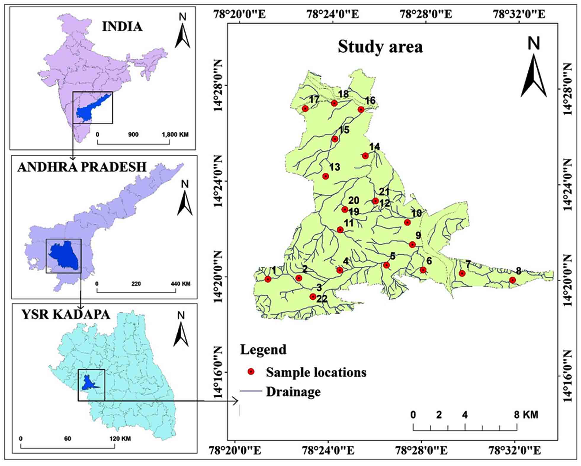
The study region lies between 78º 24ʹ 32" to 78º 05ʹ 0" E and 14º 32ʹ 0" to 14º 35ʹ 30" N (SOI toposheets: 57J/06 and 57J/11) with an area of 168.21 km2 of the Vempalle Mandal, YSR district, Andhra Pradesh (Figure 1). A tropical climate observed with an average annual temperature of 34ºC and precipitation of 753mm per year. Brown and red soils as well as loam and shallow and deep clay loam soils are observed in the region. Groundnut, sunflower, red gram, Bengal gram, paddy, cotton, and Sesamum are among the crops produced.
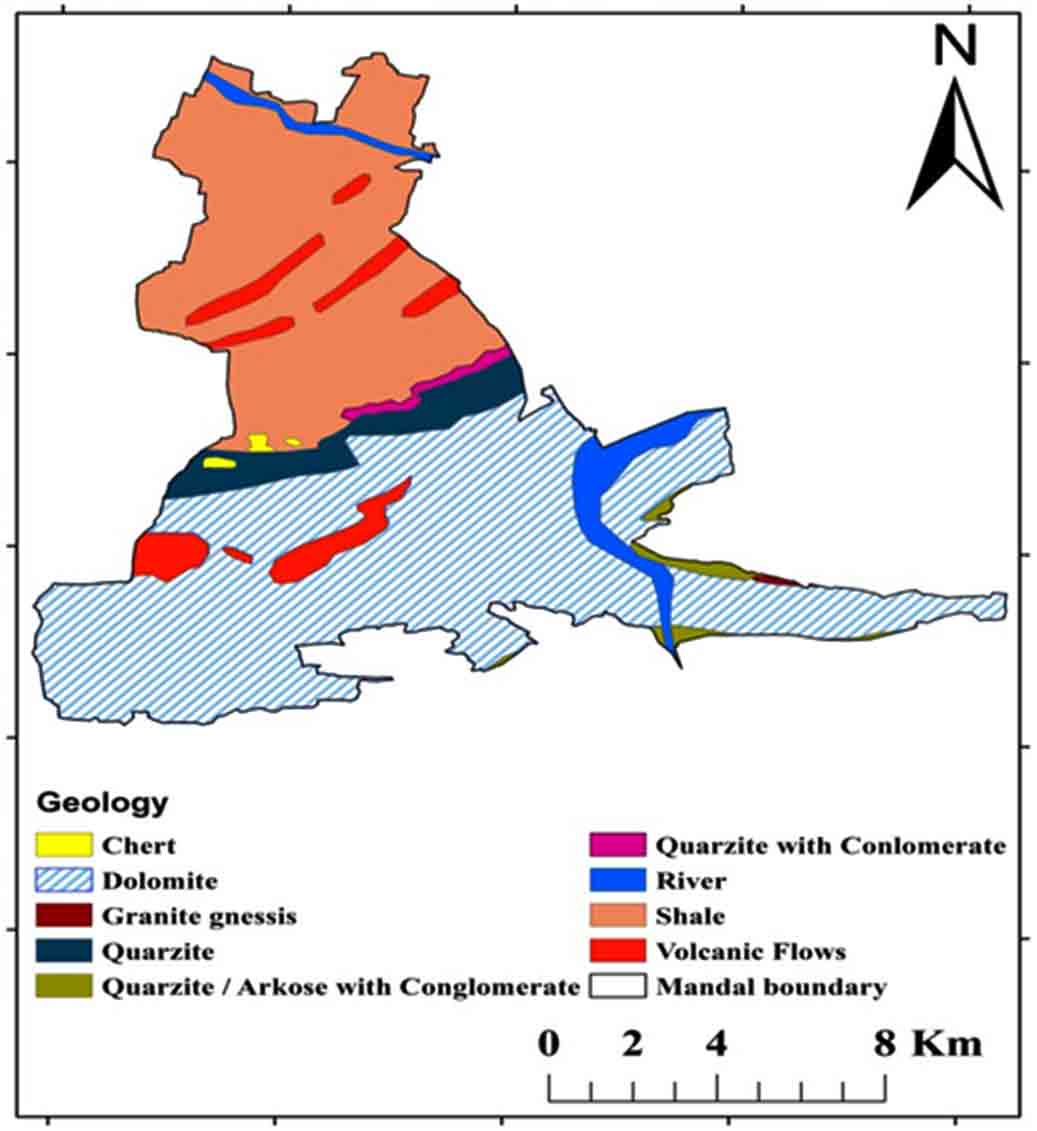
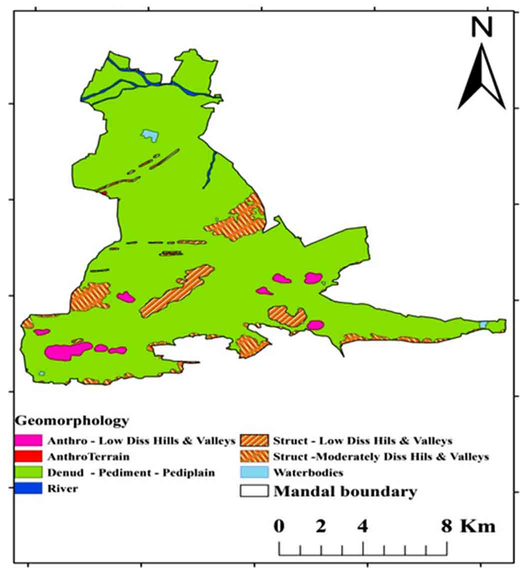
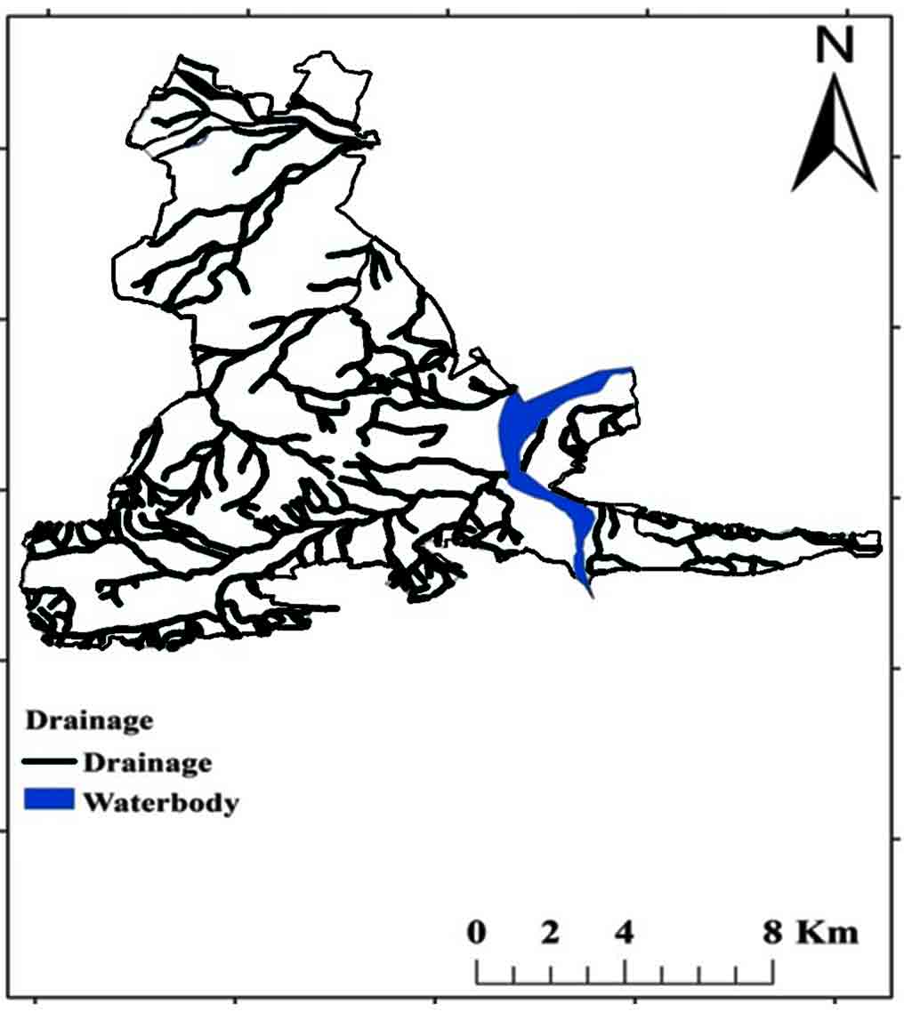
According to Zachariah (1999), the Tadipatri and Vempalle formations are 1779 Ma and 1752 Ma, respectively, and the Pulivendula formation is 1817 Ma, according to Bhaskar Rao et al., (1995). The Papaghni Group’s Vempalle Formation in the Cuddapah Supergroup is mostly composed of basic flows, dolomite, quartzite, conglomerate, and shale (Figure 2). Residual hills, Pediment, Pediplain, Structural hills and valleys are examples of geomorphological terrain generated by denudational, fluvial, and structural sources (Figure 3). The depth of the water fluctuates between 10 and 50m (CGWB, 2014). The Mogamureru River, a tributary of the Papaghni River, rises from west to east and joins the Papaghni River in Animela village in Veerapunayunipalle Mandal, with a primarily dendritic drainage pattern (Figure 4).
3. Methodology
Twenty-two samples collected from villages in the Vempalle Mandal of the YSR district. One liter storage cans were cleaned and disinfected before being preserved with nitric acid. The samples were analyzed to determine ex-site and in-site characteristics such as alkalinity (carbonates and bicarbonates), chlorides, magnesium, calcium, electrical conductivity, pH, total dissolved solids, and total hardness (Table 1). In the laboratory, alkalinity, Cl-, and Mg2+ parameters are measured using the titration method, Ca2+ is measured using a flame photometer, pH is determined using a pH meter, and EC and TDS are assessed using conductivity meter. Parameters that are compared to the ranges of the Bureau of Indian Standards are also shown in the graphs. The weighted arithmetic technique was used to calculate the Water Quality Index. The parameters and WQI values showed on the maps using the IDW tool of Arc-GIS software.
Table 1. Physico-chemical parameters
|
S. No |
Village Name |
Longitude |
Latitude |
pH |
EC |
TDS |
Ca2+ |
Mg 2+ |
CO32- |
HCO3- |
Cl- |
TH |
|
1 |
Vempalle |
78.355721° |
14.331964° |
7.9 |
1020 |
600 |
50 |
65 |
15 |
85 |
350 |
68 |
|
2 |
Edupulapaya |
78.377839° |
14.332943° |
8.5 |
968 |
575 |
125 |
82 |
47 |
69 |
110 |
87 |
|
3 |
A. Cherlopalli |
78.388129° |
14.320102° |
7.5 |
1151 |
690 |
84 |
39 |
24 |
42 |
454 |
25 |
|
4 |
Ramireddypalle |
78.407050° |
14.338755° |
8.5 |
1590 |
954 |
135 |
58 |
58 |
0 |
647 |
658 |
|
5 |
Ammaigaripalli |
78.440434° |
14.342626° |
7.7 |
634 |
390 |
65 |
112 |
12 |
36 |
100 |
125 |
|
6 |
pamuluru |
78.466688° |
14.339588° |
7.2 |
875 |
520 |
190 |
96 |
37 |
94 |
78 |
98 |
|
7 |
Alavalapadu |
78.494623° |
14.337503° |
8 |
1350 |
800 |
150 |
35 |
45 |
54 |
441 |
358 |
|
8 |
Borlagondicheruvu |
78.530698° |
14.333185° |
7.2 |
942 |
570 |
84 |
99 |
0 |
0 |
332 |
574 |
|
9 |
Naguru |
78.458748° |
14.357179° |
8.8 |
1110 |
675 |
73 |
112 |
24 |
65 |
376 |
45 |
|
10 |
Musulreddypalli |
78.455109° |
14.372630° |
7 |
954 |
590 |
100 |
58 |
29 |
38 |
320 |
39 |
|
11 |
T. Velamavaripalli |
78.407051° |
14.366983° |
7.4 |
798 |
490 |
95 |
43 |
0 |
0 |
232 |
187 |
|
12 |
Alireddypalli |
78.432104° |
14.387316° |
8.5 |
1105 |
670 |
120 |
120 |
0 |
0 |
410 |
354 |
|
13 |
Chinthalamadugupalli |
78.396207° |
14.404166° |
7.5 |
1288 |
780 |
50 |
45 |
19 |
90 |
500 |
456 |
|
14 |
kattuluru |
78.424502° |
14.418699° |
8 |
1006 |
612 |
174 |
65 |
46 |
68 |
195 |
291 |
|
15 |
kuppalapalli |
78.402485° |
14.430193° |
7.6 |
748 |
460 |
32 |
54 |
35 |
85 |
230 |
257 |
|
16 |
pamuluru |
78.420971° |
14.450894° |
8.5 |
967 |
590 |
71 |
100 |
21 |
36 |
290 |
457 |
|
17 |
Vempalli |
78.381039° |
14.451130° |
7.7 |
1120 |
670 |
89 |
87 |
27 |
65 |
364 |
354 |
|
18 |
Tallapalli |
78.401835° |
14.455093° |
7.7 |
990 |
600 |
150 |
30 |
38 |
102 |
270 |
254 |
|
19 |
Eguvathuvvapalli |
78.410204° |
14.381103° |
7 |
600 |
500 |
55 |
60 |
17 |
0 |
200 |
74 |
|
20 |
Mallepalli |
78.371232° |
14.390213° |
8 |
1000 |
650 |
90 |
118 |
25 |
70 |
420 |
550 |
|
21 |
mopurigaripalli |
78.501485° |
14.420752° |
8.3 |
700 |
590 |
86 |
85 |
44 |
80 |
300 |
130 |
|
22 |
Nandipalli |
78.512934° |
14.440371° |
8 |
620 |
750 |
35 |
125 |
35 |
100 |
445 |
200 |
3.1 Water Quality Index (WQI)
The Water Quality Index is unique measurement that identifies the root causes of contradictory water qualities. The suitability components of water for people used to calculate the WQI. pH, electrical conductivity, chloride, dissolved solids, hardness, sulphate, sodium, manganese, calcium, potassium, and magnesium were taken into account while computing WQI. The weighted computation by the WQI used in many kinds of research this type of estimates (Bouslah et al., 2017; Jamshidzadeh et al., 2018; Ekere et al., 2019; Chowdhury et al., 2021).
3.2 Weighted Arithmetic Water Quality Index
The weighted arithmetic water quality index clarifies the water quality according to the standard of quality by using the most commonly measured water quality factors. Numerous scientists have used this technique (Chauhan et al., 2010; Balan et al, 2012; Chowdhury et al., 2021) to calculate WQI (Rown et al., 1972; Xiao et al., 2019; Gao et al., 2020; Ram et al., 2021):
\(K = {1 \over \sum({1 \over Si})}\)
where, k denotes steady-state proportionality, Si is standards of parameter.
The sub-index (Wi) was calculated by taking the parameter’s optimal (ideal) value:
\(Wi = {K \over Si}\)
The following formula used to calculate the sub-index (Qi).
\(Wi = 100 [{Vi-V0 \over Si-V0}]\)
where, Vi is concentrate of the parameter in analyzing water, Si is standard desirable value of parameter, Vo is the parameter’s actual value in pure water (for natural water and Vo is 0 for hardness.
\(WQI= {\sum Wi Qi \over \sum Wi}\)
where, WQI is a number between 0 and 100 that indicates the quality of the water; Qi is a relative value of water specific to each parameter; i is represent the range of parameters.
4. Results And Discussion
4.1 pH
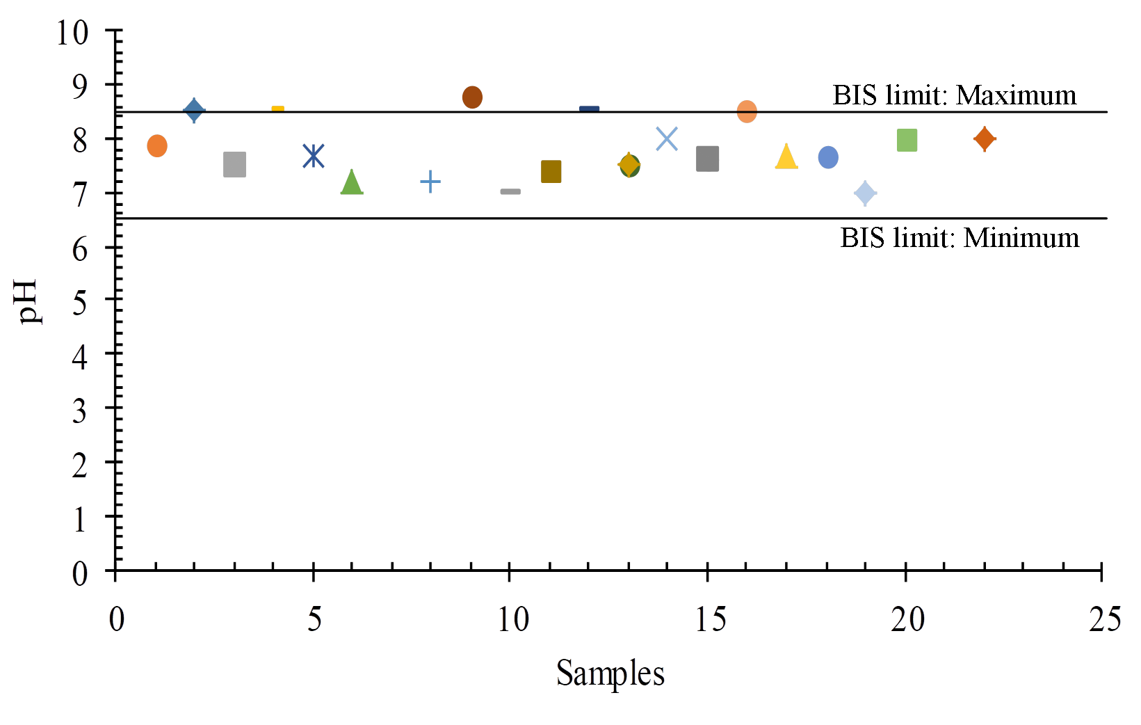
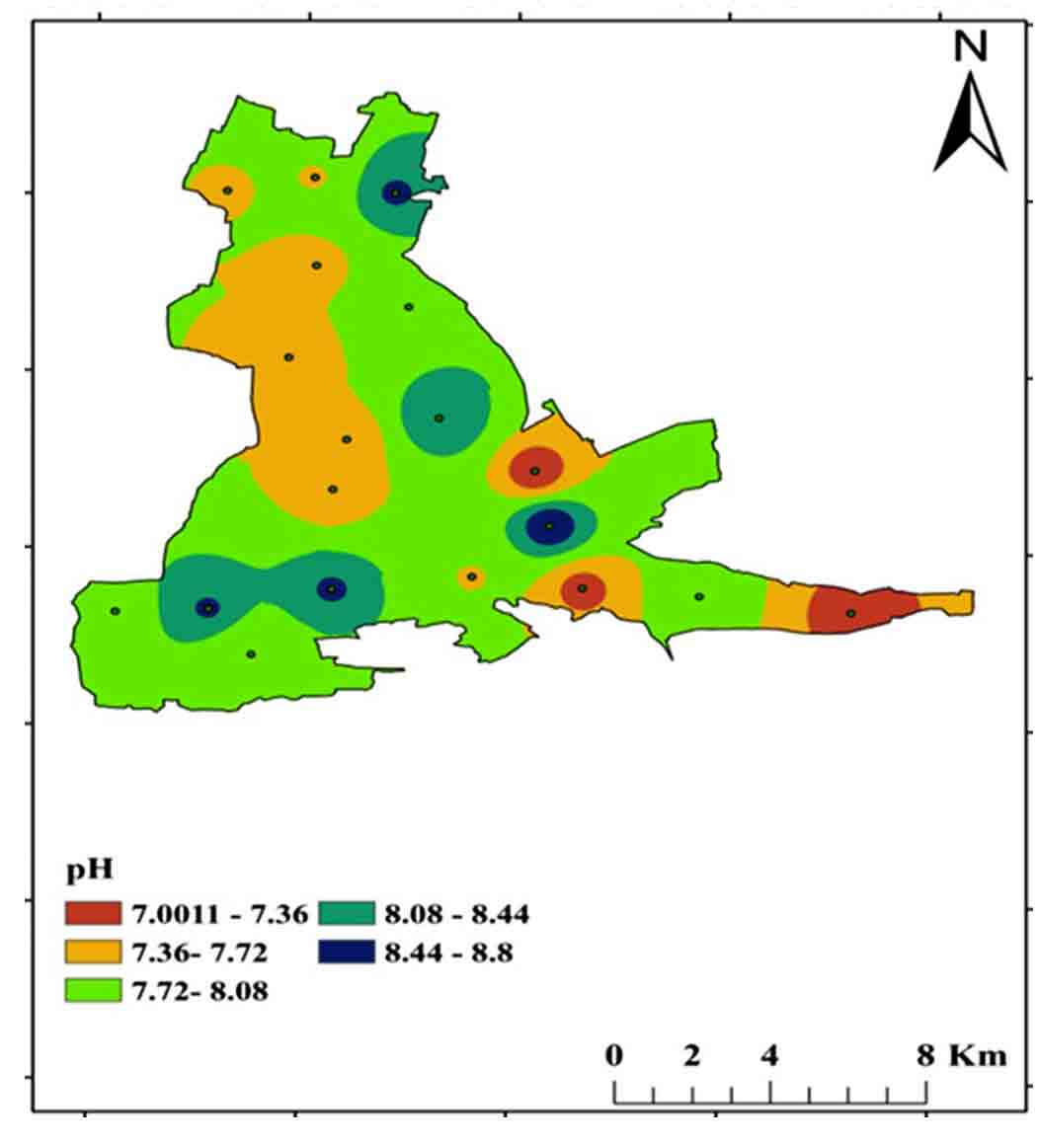
The quality and penetration rate of groundwater recharge, the rate of refilling water, and the interaction between water and rock in the aquifer all influence pH fluctuations in space and time. The recommended BIS limit for drinking purposes is 6.5 to 8.5 pH, and in the study area ranges from 7.0 to 8.8 (Figures 5 and 6).
4.2 Electrical Conductivity
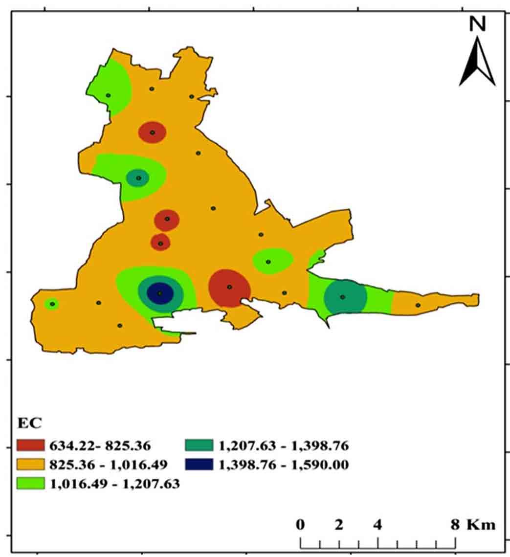
Electrical conductivity defined as its ability to conduct an electric current. When salts or other chemical substances dissolve which divided into positive and negative ions. Electrical conductivity can be classed into four categories: excellent, good, permitted, and dubious (Tlili-Zrelli et al., 2018). The study region ranges from 600 to 1590 μS/Cm, with samples falling into the good and permissible categories (Table 2; Figure 7).
Table 2. Electrical conductivity
|
Water classes |
EC |
Samples |
Sample |
|
No. |
% |
||
|
Excellent |
<250 |
- |
- |
|
Good |
250-750 |
4 |
18 |
|
Permissible |
750-2250 |
18 |
82 |
|
Doubtful |
>2250 |
- |
- |
4.3 Total Dissolved Solids (TDS)
TDS is an abbreviation for total dissolved solids, which are inorganic and small amounts of organic components that are present in water as a solution. For drinking purposes, the BIS (2012) permissible limit is 500 mg/L to 2000 mg/L, with a range of 390-954 mg/L in the study region (Figure 10 and 8). Fresh water, slightly brackish water, slightly brackish water, brackish water, saline water, and braine water are the six forms of TDS (Ramaraju and Giridhar 2017). All samples were fallen into freshwater category and the TDS (Table 3).
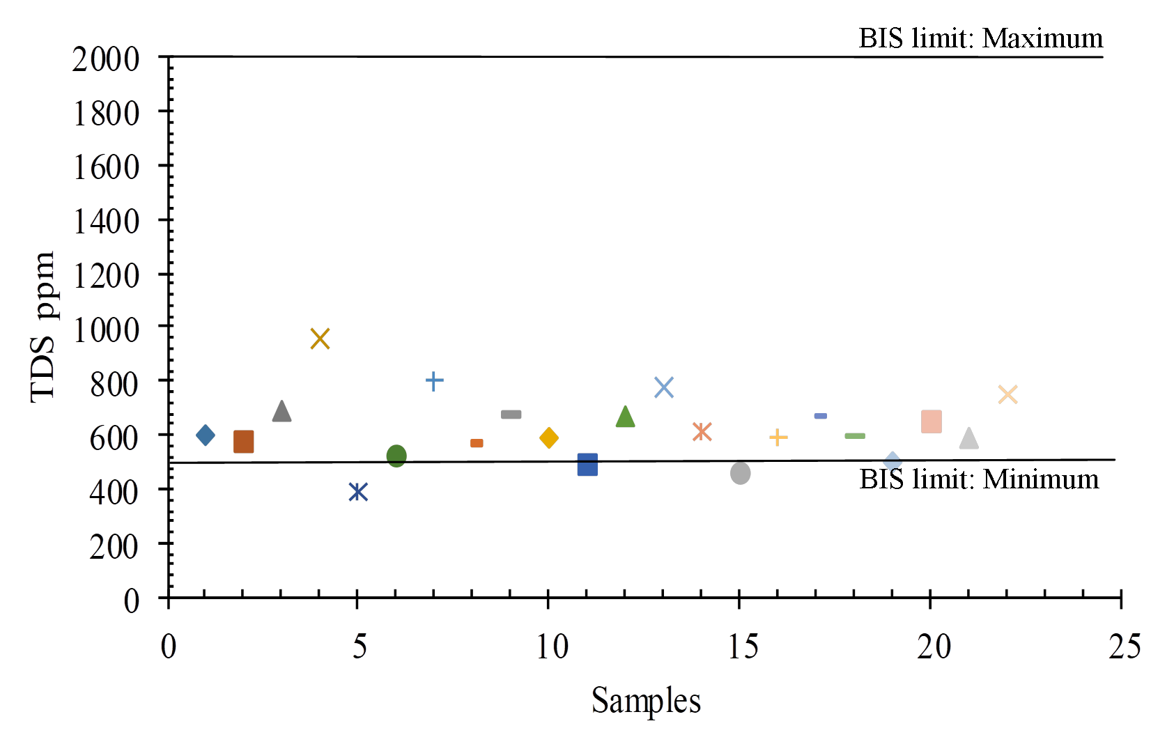
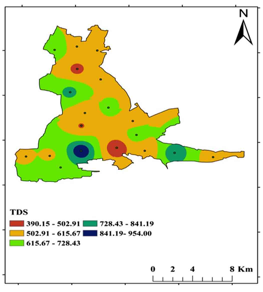
Table 3. Total Dissolved Solids
|
Water Class |
Concentration of TDS (Todd 2005) mg/l |
No. of Samples |
|
Fresh water |
10-1000 |
All |
|
Slightly water |
------- |
- |
|
Slightly-brackish water |
1000-10,000 |
- |
|
Brackish water |
10,000-10,0000 |
- |
|
Saline water |
----- |
- |
|
Braine water |
>10,0000 |
- |
4.4 Hardness
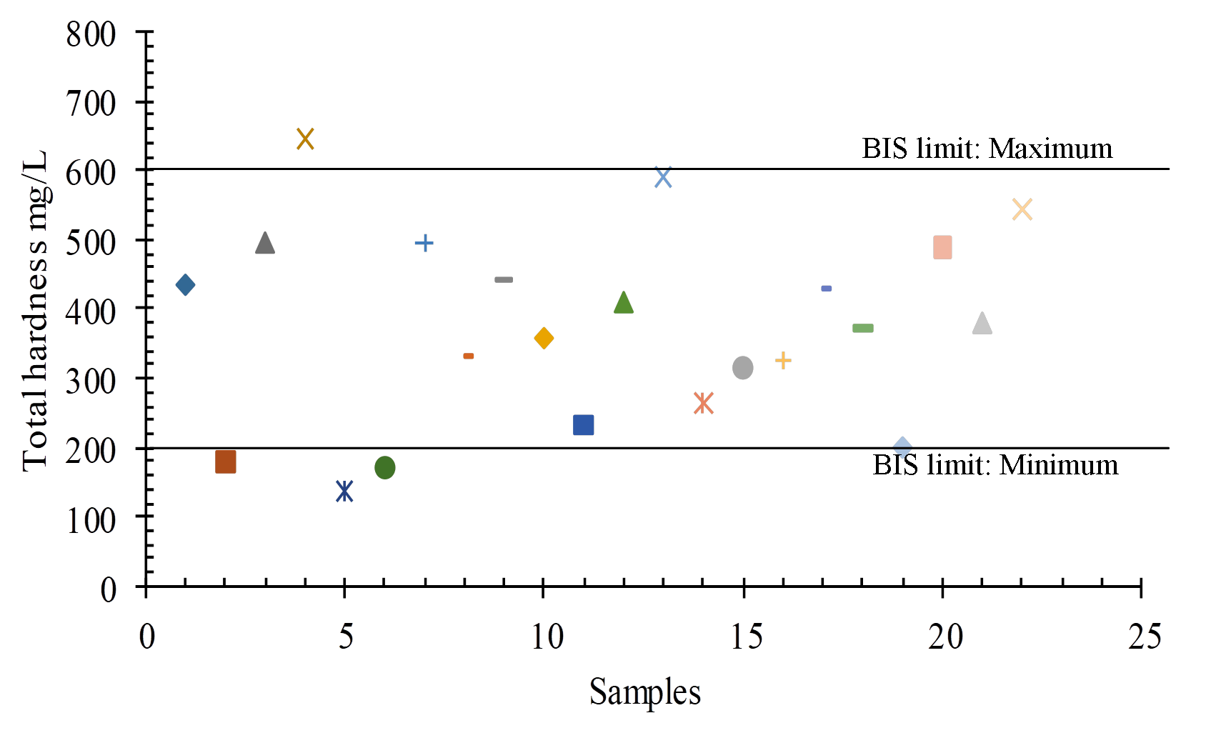
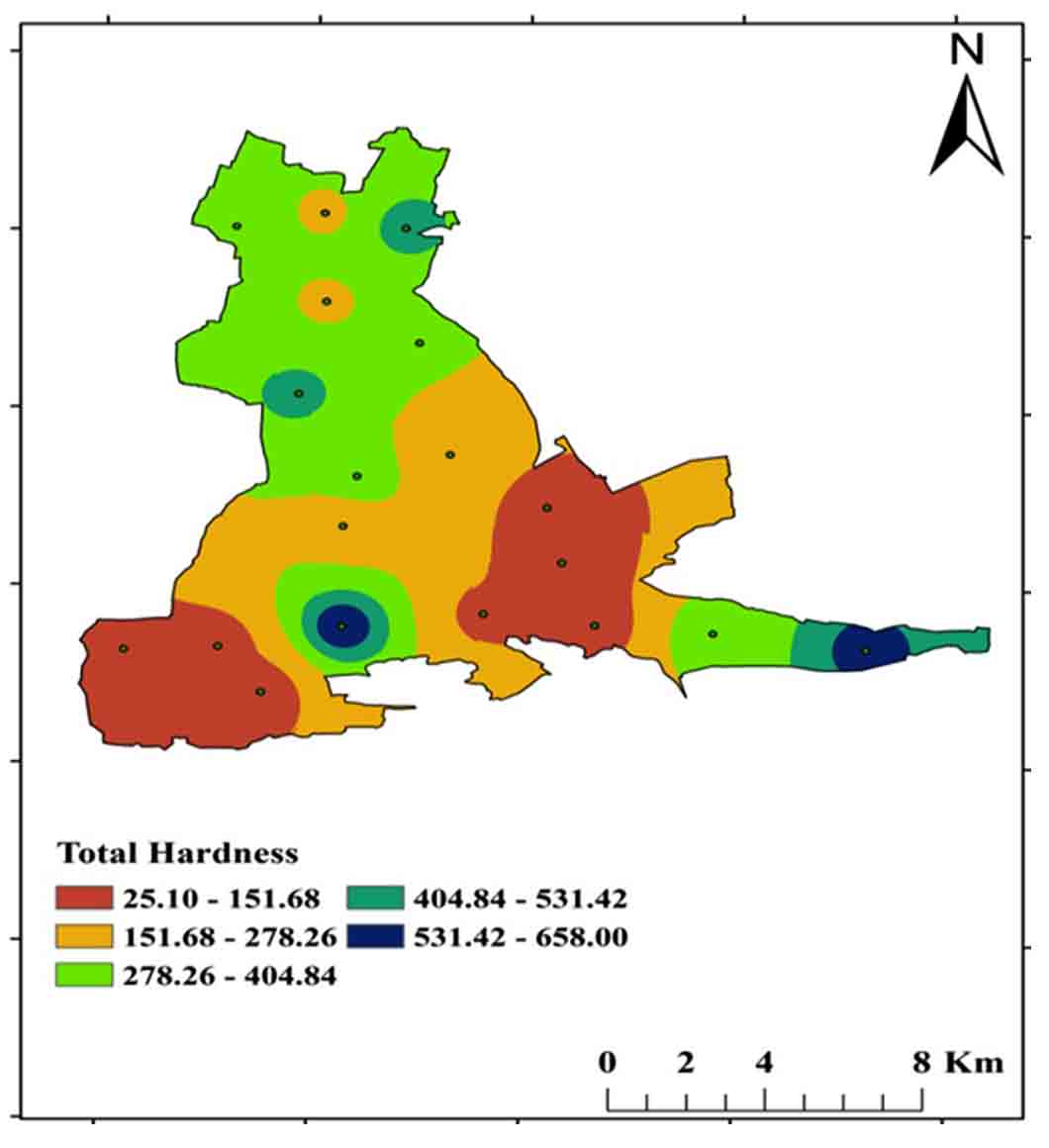
Dissolved polyvalent metallic ions from sedimentary rocks such as limestone and dolomite are the most common causes of hardness in water, and the two main ions are Ca2+ and Mg 2+. Carbonate (temporary) and non-carbonate (permanent) hardness are two types of total hardness. For drinking purposes, the BSI (2012) permissible range is 200 mg/L to 600 mg/L TH, with a range of 25mg/L-658 mg/L in the study region (Figure 9 and 11).
Total hardness (mg/l as CaCO3) = Carbonate hardness + Non-carbonate hardness
\(Calcium \ Hardness = 20 { mg \over L} {\times} {{(100 \ Caco3)⁄Mm} \over (400 mg \ Calcium)⁄Mm} mg/L\)
\(Magnesium \ Hardness = 10 { mg \over L} {\times} {{(100 \ Caco3)⁄Mm} \over (24.31 mg \ Calcium)⁄Mm} mg/L\)
4.5 Calcium
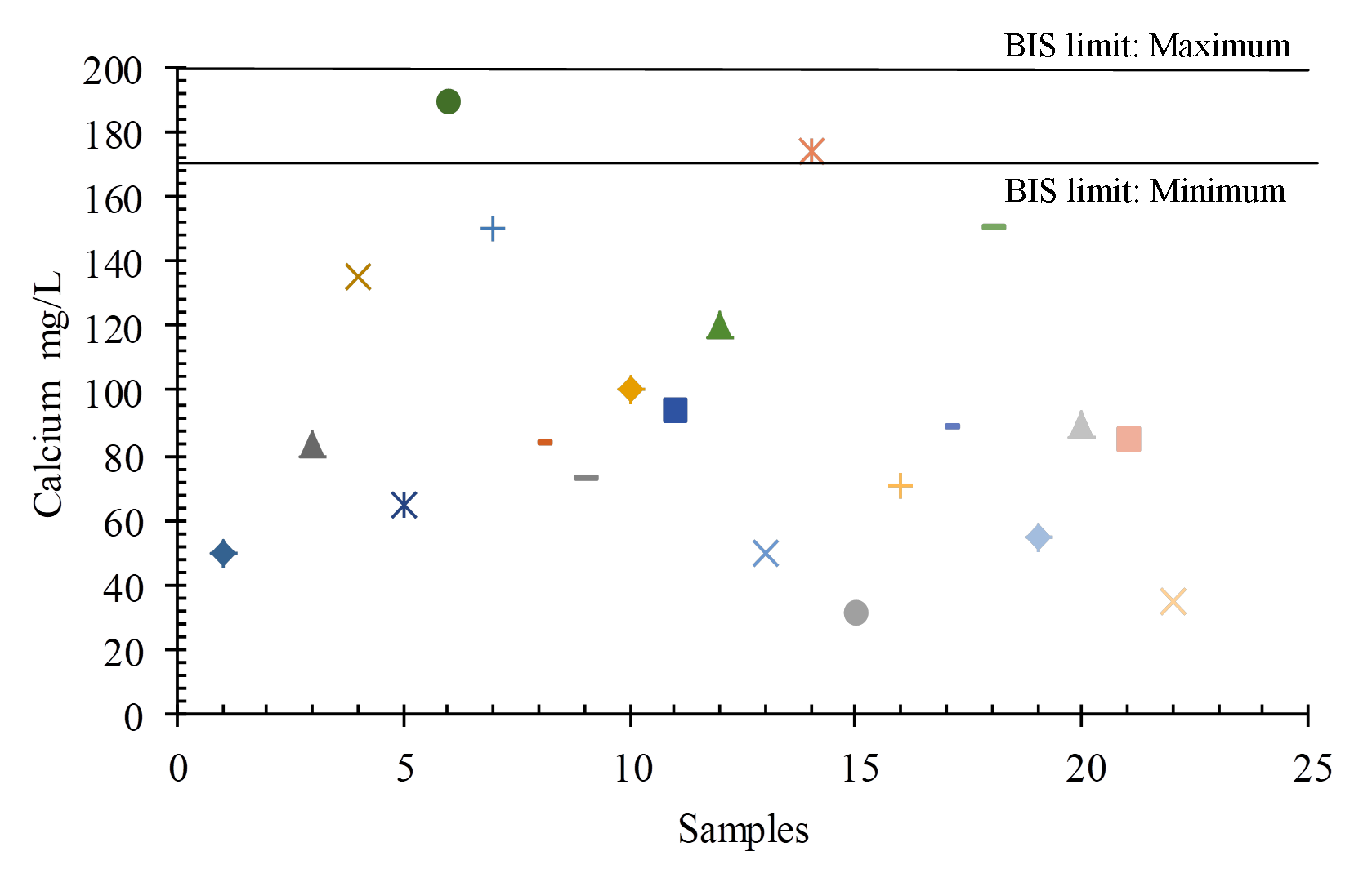
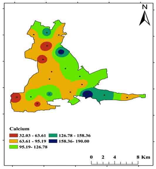
Calcium (Ca2+) may dissolve from rocks such as limestone and dolomite in the study area. For drinking purposes, the BIS (2012) permissible limit is Ca2+ 75 mg/L to 200 mg/L, whereas in the study area ranges between 32 mg/Land 190 mg/L (Figures 12 and 14).
4.6 Magnesium
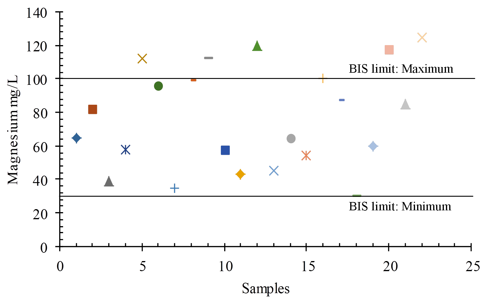
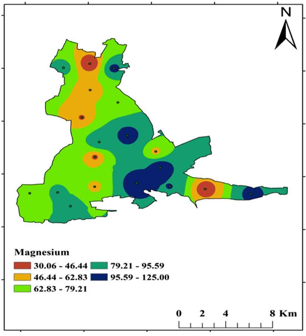
Magnesium (Mg2+) is the most abundant element in the earth’s crust and is formed by the weathering of specific minerals such as dolomite. Magnesium, together with calcium, is necessary for water hardness. For drinking purposes, the BIS (2012) permissible limit is Mg2+ from 30 mg/L to 100 mg/L, and concentrations ranging from 30 mg/L-125 mg/L in the study area (Figure 13 and 15).
4.7 Carbonates (CO3-) and Bicarbonates (HCO3-)
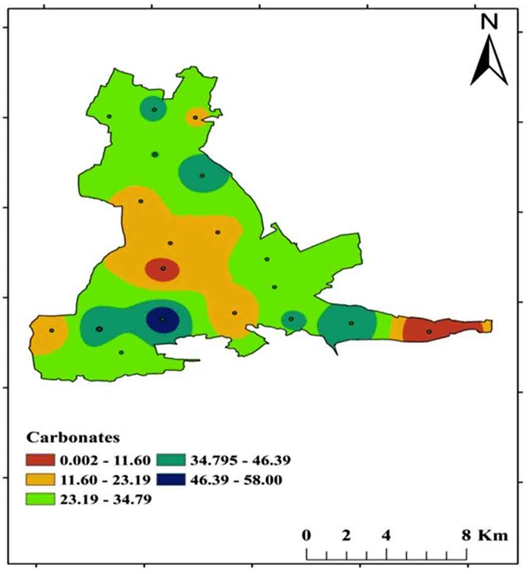
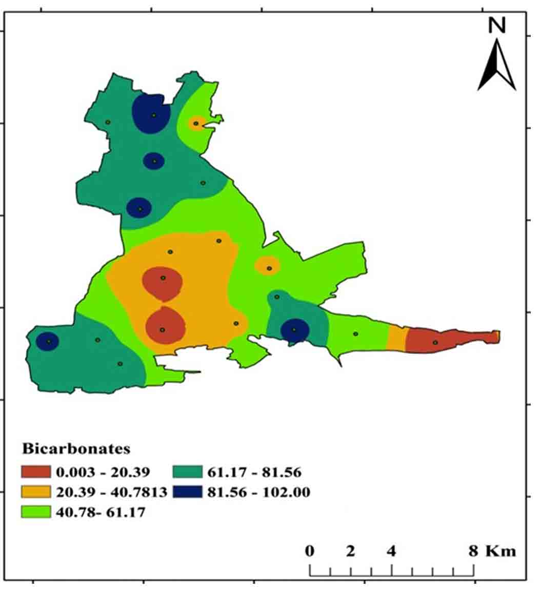
Carbonates (CO32-), Bicarbonates (HCO3-), and hydroxide compounds, as well as Phosphates, Silicates, and Borates, make up the alkaline character of water. Carbonates are typically found in carbonaceous rocks such as limestone, and this sort of environment has a high alkalinity and hardness. CO3- and HCO3- concentrations in the research area range from 0-58 mg/L and 0-102 mg/L, respectively. Soft water has low alkalinity, while hard water has significant alkalinity Figure 16 and 17 shows a spatial distribution map of CO3- and HCO3- concentrations.
4.8 Water Quality Index (WQI)
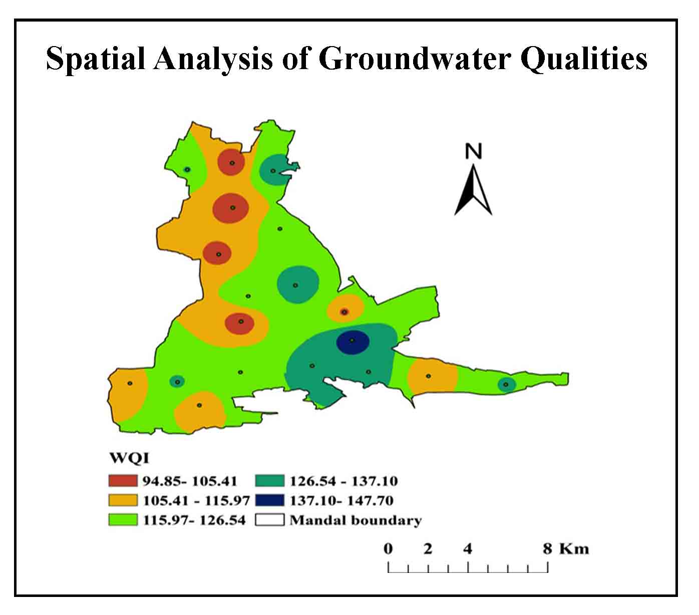
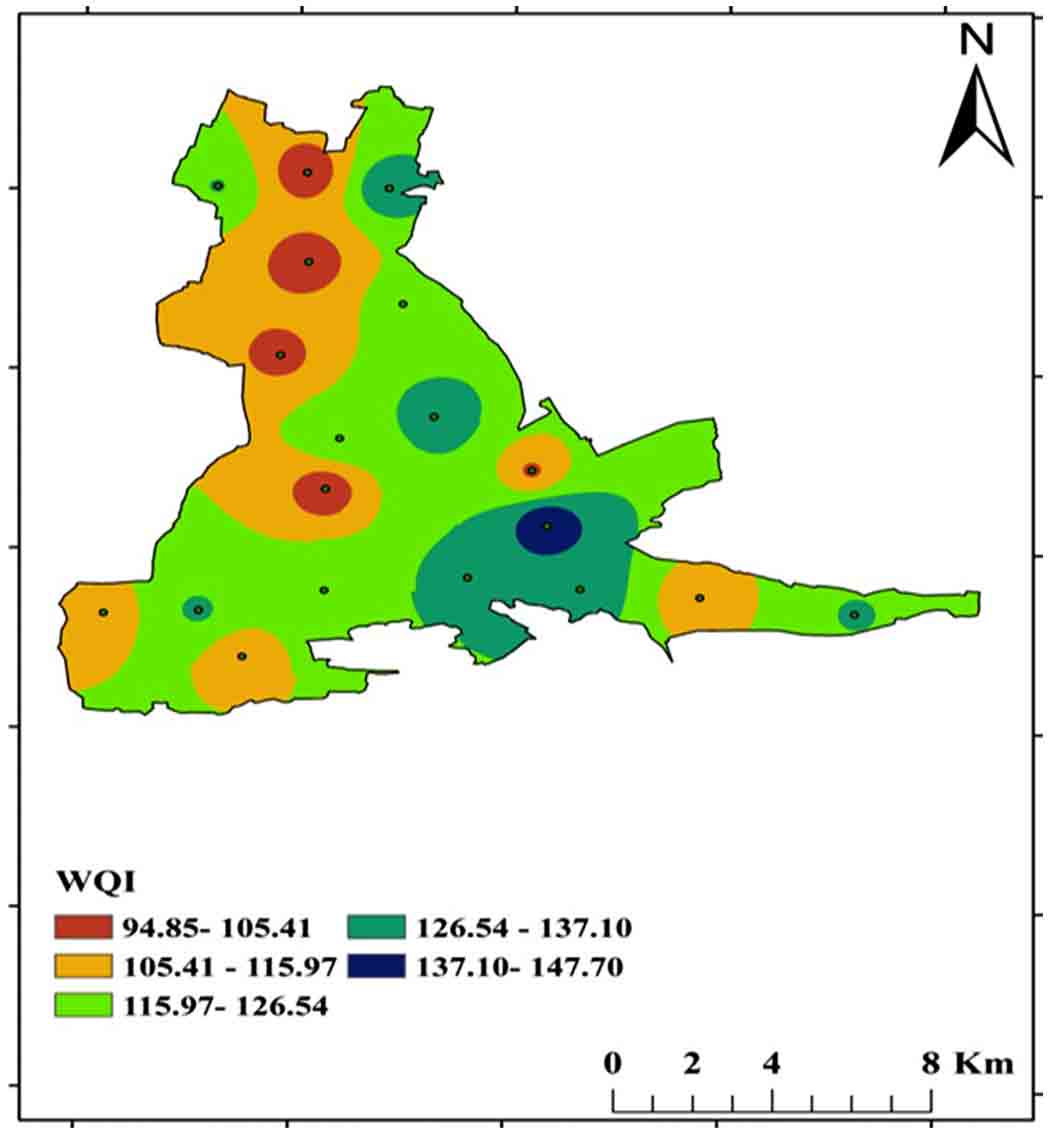
The value generated for the Weighted Arithmetic WQI technique can be used to calculate the water ecological popularity. Table 4 shows the water quality criteria for drinking purposes and the unit-weights allocated to each parameter used in calculating the WQI. Brown (1972) categorizes the WQI into five classes (Table 5). Four samples from villages namely Cherlopalli, T. Velamavaripalli, Kuppapalapalli, Tallapalli, and Eguvathuvvapalli classified into poor category and others falling into the unsuitable category (Table 6, Figure 18).
Table 4. Relative weights (Wn) used to calculate the WQI
|
Parameters |
BIS standard (Vs) |
Ranges |
Unit weight (Wn) |
|
pH |
8.5 |
7.0-8.8 |
0.60 |
|
EC |
300 |
634-1590 |
0.02 |
|
TDS |
500 |
390-954 |
0.010 |
|
TH |
300 |
25-658 |
0.02 |
|
Ca2+ |
75 |
32-190 |
0.10 |
|
Mg2+ |
30 |
30-120 |
0.20 |
|
TA |
200 |
58- 102 |
0.03 |
|
Cl- |
250 |
78-647 |
0.02 |
|
Σ Wn |
1 |
Table 5. Classification of the Water Quality Index (Brown 1972)
|
Water Quality Class |
Range |
Grade |
Possible Usage |
No. of Samples |
|
Excellent |
0-25 |
A |
Drinking, irrigation and industrial |
- |
|
Good |
26-50 |
B |
Drinking, irrigation and industrial |
- |
|
Poor |
51-75 |
C |
Irrigation and industrial |
- |
|
Very Poor |
76-100 |
D |
Irrigation |
5 |
|
Unsuitable |
>100 |
E |
Proper treatment required before use |
17 |
Table 6. WQI categories
|
Sample Id |
Longitude |
Latitude |
WQI Values |
WQI Category |
|
V1 |
78.355721° |
14.331964° |
111.6 |
Unsuitable |
|
V2 |
78.377839° |
14.332943° |
128.5 |
Unsuitable |
|
V3 |
78.388129° |
14.320102° |
98.6 |
Very Poor |
|
V4 |
78.407050° |
14.338755° |
126.2 |
Unsuitable |
|
V5 |
78.440434° |
14.342626° |
131.4 |
Unsuitable |
|
V6 |
78.466688° |
14.339588° |
132.5 |
Unsuitable |
|
V7 |
78.494623° |
14.337503° |
107.3 |
Unsuitable |
|
V8 |
78.530698° |
14.333185° |
126.8 |
Unsuitable |
|
V9 |
78.458748° |
14.357179° |
147.7 |
Unsuitable |
|
V10 |
78.455109° |
14.372630° |
104.1 |
Unsuitable |
|
V11 |
78.407051° |
14.366983° |
94.8 |
Very Poor |
|
V12 |
78.432104° |
14.387316° |
153.6 |
Unsuitable |
|
V13 |
78.396207° |
14.404166° |
101.4 |
Unsuitable |
|
V14 |
78.424502° |
14.418699° |
121.1 |
Unsuitable |
|
V15 |
78.402485° |
14.430193° |
98.01 |
Very Poor |
|
V16 |
78.420971° |
14.450894° |
135.8 |
Unsuitable |
|
V17 |
78.381039° |
14.451130° |
126.9 |
Unsuitable |
|
V18 |
78.401835° |
14.455093° |
98.3 |
Very Poor |
|
V19 |
78.410204° |
14.381103° |
96.5 |
Very Poor |
|
V20 |
78.371232° |
14.390213° |
146.9 |
Unsuitable |
|
V21 |
78.501485° |
14.420752° |
109.7 |
Unsuitable |
|
V22 |
78.512934° |
14.440371° |
126.1 |
Unsuitable |
5. Conclusion
The BIS (2012) establishes the study for the evaluation of groundwater samples for drinking and irrigation purposes. The collected samples analyzed to determine ex-site and in-site characteristics such as alkalinity (carbonates and bicarbonates), chlorides, magnesium, calcium, electrical conductivity, pH, total dissolved solids, and total hardness. The weighted arithmetic technique used to calculate the Water Quality Index. The parameters and WQI values plotted to show spatial distribution using the IDW tool of Arc-GIS software.
The EC of groundwater is good in 18% of the samples and permissible in 82% of the samples. Most of the samples are permissible resulting in high EC values. Absolute TDS, hardness, calcium, magnesium bicarbonates, and carbonates classified into permissible limits. WQI estimated for 22.8% samples classified as very poor and 77.2% are unsuitable. Water collected from these samples contaminated due to mining in the region. Very poor quality groundwater is useful only for irrigation purposes.
Conflict of interest
The authors declare no conflict of interest.
Abbreviations
BIS: Bureau of Indian Standards; CGWB: Central Groundwater Board; EC: Electrical Conductivity; GIS: Geographic information system; RS: Remote Sensing; TDS: Total Dissolved Solids; TH: Total Hardness; WHO: World Health Organization; WQI: Water Quality Index.
Article information
- Received
- 22 Jan 2022
- Revised
- 1 Apr 2022
- Accepted
- 2 Apr 2022
- Published
- 24 Apr 2022
- Handling editor
- Dr. Pramodkumar Hire
- Licence
- CC BY-NC-ND 4.0
- Journal
- Hydrospatial Analysis, ISSN 2582-2969
References
-
Adimalla, N., 2021. Application of the entropy weighted water quality index (EWQI) and the pollution index of groundwater (PIG) to assess groundwater quality for drinking purposes: A case study in a rural area of Telangana State, India. Archives of Environmental Contamination and Toxicology, 80(1), 31-40.
Crossref -
Balamurugan, P., Shunmugapriya, G. and Vanitha, R., 2020. GIS based assessment of ground water for domestic and irrigation purpose in Vazhapadi Taluk, Salem, Tamil Nadu, India. Taiwan Water Conservancy, 68(2), 1-10.
-
Balan, I. N., Shivakumar, M. and Kumar, P. D., 2012. An assessment of groundwater quality using water quality index in Chennai, Tamil Nadu, India. Chronicles of Young Scientists, 3(2), 146.
-
Bhaskar Rao, Y. J., Pantulu, G. V. C., Reddy, D. V., and Gopalan, K., 1995. Time of early sedimentation and volcanism in the Proterozoic Cuddapah basin, South India: Evidence from Rb-Sr age of Pulivendla mafic sill. Geological Society of India, 33, 329-338.
-
Bhutiani, R., Ahamad, F., Tyagi, V. and Ram, K., 2018. Evaluation of water quality of River Malin using water quality index (WQI) at Najibabad, Bijnor (UP) India. Environment Conservation Journal, 19 (1 and 2), 191-201.
Crossref -
BIS [Bureau of Indian Standards] 2012. Drinking water - specification (Second revision May 2012), New Delhi.
-
Bora, M. and Goswami, D. C., 2017. Water quality assessment in terms of water quality index (WQI): Case study of the Kolong River, Assam, India. Applied Water Science, 7(6), 3125-3135.
Crossref -
Bouslah, S., Lakhdar, D. and Larbi, H., 2017. Water quality index assessment of Koudiat Medouar Reservoir, northeast Algeria using weighted arithmetic index method. Journal Of Water And Land Development, 35, 221-228.
Crossref -
Brown, R. M., McClelland, N. I., Deininger, R. A. and O’Connor, M.F., 1972. A water quality index- Crashing the psychological barrier. In Indicators Of Environmental Quality, 173-182, Springer, Boston, MA.
-
CGWB [Central Groundwater Board] 2014. Report on dynamic groundwater resources of India (as on March 2011). Central Groundwater Board, Ministry of Water Resources, River Development and Ganga Rejuvenation, Government of India, Faridabad, 1-282.
-
Chauhan, A. and Singh, S., 2010. Evaluation of Ganga water for drinking purpose by water quality index at Rishikesh, Uttarakhand, India. Report and Opinion, 2(9), 53-61.
-
Chowdhury, R. M., Ankon, A A. and Bhuiyan, M. K., 2021. Water Quality Index (WQI) of Shitalakshya River Near Haripur Power Station, Narayanganj, Bangladesh. Journal of Engineering Science, 12(3), 45-55.
Crossref -
Dash, S. and Kalamdhad, A.S., 2021. Hydrochemical dynamics of water quality for irrigation use and introducing a new water quality index incorporating multivariate statistics. Environmental Earth Sciences, 80(3), 1-21.
Crossref -
Ekere, N. R., Agbazue, V. E., Ngang, B. U. and Ihedioha, J. N., 2019. Hydrochemistry and Water Quality Index of groundwater resources in Enugu north district, Enugu, Nigeria. Environmental Monitoring And Assessment, 191(3), 1-15.
Crossref -
Gao, Y., Qian, H., Ren, W., Wang, H., Liu, F. and Yang, F., 2020. Hydrogeochemical characterization and quality assessment of groundwater based on integrated-weight water quality index in a concentrated urban area. Journal Of Cleaner Production, 260, 121006.
Crossref -
Gowd, S. S., 2005. Assessment of groundwater quality for drinking and irrigation purposes a case study of Peddavanka watershed, Anantapur District Andhra Pradesh, India. Environmental Geology 48(6), 702-712.
Crossref -
Jamshidzadeh, Z. and Barzi, M. T., 2018. Groundwater quality assessment using the potability water quality index (PWQI): A case in the Kashan plain, Central Iran. Environmental Earth Sciences, 77(3), 1-13.
Crossref -
Lapworth, D. J., MacDonald, A. M., Kebede, S., Owor, M., Chavula, G., Fallas, H., Wilson, P., Ward, J.S.T., Lark, M., Okullo, Mwathunga, E., Banda, S., Gwengweya, G., Nedaw, D., Jumbo, S., Banks, E., Cook, P. and Casey, V., 2020. Drinking water quality from rural handpump-boreholes in Africa. Environmental Research Letters, 15(6), 064020.
Crossref -
Li, P. and Wu, J., 2019. Drinking water quality and public health. Exposure and Health, 11(2), 73-79.
Crossref -
Manoj, S., Thirumurugan, M. and Elango, L., 2017. An integrated approach for assessment of groundwater quality in and around uranium mineralized zone, Gogi region, Karnataka, India. Arabian Journal of Geosciences, 10(24), 1-17.
Crossref -
Oki, A. O. and Akana, T. S., 2016. Quality assessment of groundwater in Yenagoa, Niger delta, Nigeria. Geosciences, 6(1), 1-12.
Crossref -
Panneerselvam, B., Muniraj, K., Thomas, M. and Ravichandran, N., 2021. GIS-based legitimatic evaluation of groundwater’s health risk and irrigation susceptibility using water quality index, pollution index, and irrigation indexes in semiarid region. In Groundwater resources development and planning in the semi-arid region, 239-268. Springer, Cham.
Crossref -
Ram, A., Tiwari, S. K., Pandey, H. K., Chaurasia, A. K., Singh, S. and Singh, Y. V., 2021. Groundwater quality assessment using water quality index (WQI) under GIS framework. Applied Water Science, 11(2), 1-20.
Crossref -
Ramaraju, A. and Giridhar, M. V. S. S., 2017. Quality Assessment of Surface Water Bodies in and around GHMC. In National Conference on Water Environment and Society, 322.
-
Rown, R.M., McCleiland, N.J., Deiniger, R.A. and O’Connor, M.F.A., 1972. Water quality index–crossing the physical barrier. In Proceedings in International Conference on water pollution Research Jerusalem, 6, 787-797.
-
Seth, R., Mohan, M., Singh, P., Singh, R., Dobhal, R., Singh, K. P. and Gupta, S., 2016. Water quality evaluation of Himalayan rivers of Kumaun region, Uttarakhand, India. Applied Water Science, 6(2), 137-147.
Crossref -
Siebert, S., Burke, J., Faures, J.M., Frenken, K., Hoogeveen, J., Döll, P. and Portmann, F.T., 2010. Groundwater use for irrigation- A global inventory. Hydrology and earth system sciences, 14(10), 1863-1880.
Crossref -
Soujanya Kamble, B., Saxena, P. R., Kurakalva, R. M. and Shankar, K., 2020. Evaluation of seasonal and temporal variations of groundwater quality around Jawaharnagar municipal solid waste dumpsite of Hyderabad city, India. SN Applied Sciences, 2(3), 1-22.
Crossref -
Srinivasamoorthy, K., Gopinath, M., Chidambaram, S., Vasanthavigar, M. and Sarma, V.S., 2014. Hydrochemical characterization and quality appraisal of groundwater from Pungar sub basin, Tamilnadu, India. Journal of King Saud University-Science, 26(1), 37-52.
Crossref -
Tlili-Zrelli, B., Gueddari, and, M. and Bouhlila, R., 2018. Spatial and temporal variations of water quality of Mateur aquifer (Northeastern Tunisia): suitability for irrigation and drinking purposes. Journal of Chemistry.
Crossref -
Tyagi, S., Singh, P., Sharma, B. and Singh, R., 2014. Assessment of water quality for drinking purpose in district Pauri of Uttarakhand, India. Applied Ecology and Environmental Sciences, 2(4), 94-99.
Crossref -
Vishnu Radhan, R., Zainudin, Z., Sreekanth, G. B., Dhiman, R., Salleh, M. and Vethamony, P., 2017. Temporal water quality response in an urban river: a case study in peninsular Malaysia. Applied Water Science, 7(2), 923-933.
Crossref -
WHO [World Health Organization] 2017. Global hepatitis report 2017. World Health Organization.
-
Wu, Z., Zhang, D., Cai, Y., Wang, X., Zhang, L. and Chen, Y., 2017. Water quality assessment based on the water quality index method in Lake Poyang: The largest freshwater lake in China. Scientific reports, 7(1), 1-10.
Crossref -
Xiao, J., Wang, L., Deng, L. and Jin, Z., 2019. Characteristics, sources, water quality and health risk assessment of trace elements in river water and well water in the Chinese Loess Plateau. Science of the Total Environment, 650, 2004-2012.
Crossref -
Yadav, K. K., Gupta, N., Kumar, V., Sharma, S. and Arya, S., 2015. Water quality assessment of Pahuj River using water quality index at Unnao Balaji, MP, India. Int J Sci Basic Appl Res, 19(1), 241-250.
-
Zachariah, J. K., Rao, Y. B., Srinivasan, R. and Gopalan, K., 1999. Pb, Sr and Nd isotope systematics of uranium mineralised stromatolitic dolomites from the Proterozoic Cuddapah Supergroup, South India: Constraints on age and provenance. Chemical Geology, 162(1), 49-64.
Crossref