

Hydrospatial Analysis Volume 2 (2018), Issue 1 · pp. 16-27
Original Research Paper Open Access

Integrated Geomorphological Geospatial and AHP Technique for Groundwater Prospects Mapping in Basaltic Terrain
- Department of Geology, Savitribai Phule Pune University, Pune, India
- Department of Environmental Sciences, Savitribai Phule Pune University, Pune - 411 007 (India).
- Department of Geology, Savitribai Phule Pune University, Pune - 411 007 (India).
* Corresponding author: Ajaykumar Kadam, kadamajaykumar1@gmail.com
Contents
Highlights
- Integration of geomorphological and geospatial thematic data was used to delineate groundwater prospects zones.
- A multicriteria technique, the analytical hierarchical process (AHP) was used for weighted overlay analysis.
- Results reveal about 44.62% of the total study area to have very high groundwater potential.
- The methodology can be applied effectively to assess groundwater potential in semi-arid regions.
Abstract
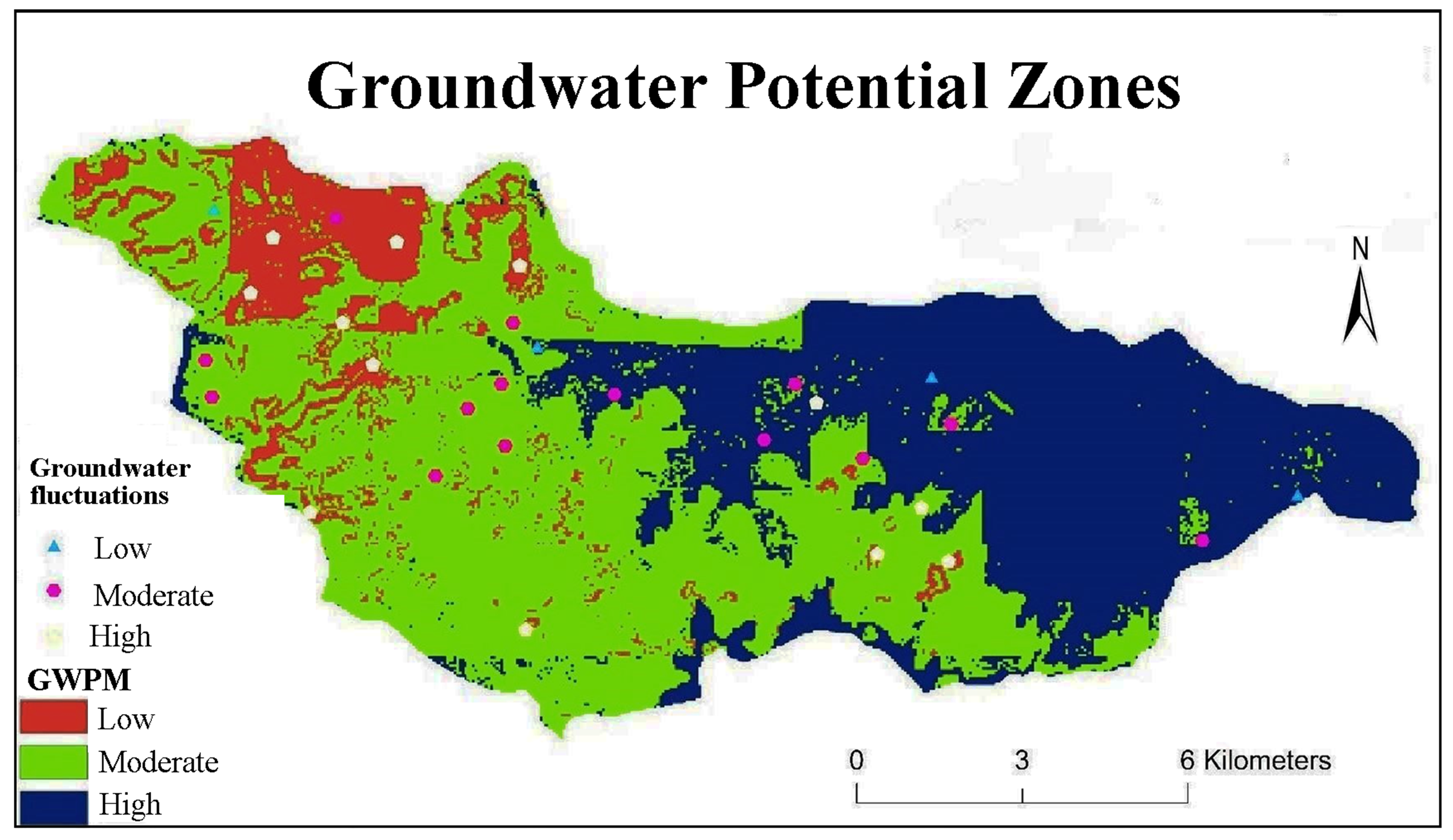
Groundwater is an important source of drinking water in rural parts of India. Because of the increasing demand for water, it is essential to identify new sources for the sustainable development of this resource. The potential mapping and exploration of groundwater resources have become a breakthrough in the field of hydrogeological research. In the present paper, a groundwater prospects map is delineated for the assessment of groundwater availability in Kar basin on basaltic terrain, using remote sensing and Geographic Information System (GIS) techniques. Various thematic layers such as geology, slope, soil, geomorphology, drainage density and rainfall are prepared using satellite data, topographic maps and field data. The ranks and weights were assigned to each thematic layer and various categories of those thematic layers using AHP technique respectively. Further, a weighted overlay analysis was performed by reclassifying them in the GIS environment to prepare the groundwater potential map of the study area. The results show that groundwater prospects map classified into three classes low, moderate and high having area 17.12%, 38.26%, 44.62%, respectively. The overlay map with the groundwater potential zones in the study area has been found to be helpful for better planning and managing the resources.
Keywords GeomorphologyGISAHPgroundwater prospects mappingBasaltic terrain
1. Introduction
Water is the most precious natural resource, which is consumed and used universally. With the increasing population, there is an ever growing demand for this precious resource. Most regions have rainfall limited to specific months of the year and some regions even lack a perennial source of water. The use of groundwater to solve this problem has increased considerably in the recent years. With the increase in the use of groundwater also comes it misuse and mismanagement. This misuse ranges from the overuse of the resource and also its pollution. Artificial recharge practices sometimes lead to pollution and also give misleading results about water table interpolation. Thus its assessment becomes critical for the sustainable development and management of groundwater resources (Magesh et al., 2012; Gashaw et al., 2018; Kadam et al., 2018).
Remote sensing (RS) and GIS methods are extensively used for the managing of various natural resources (Singhai et al. 2017; Kadam et al. 2012; Alizadeh et al. 2017; Mekuriaw et al. 2017; Gashaw et al. 2018). In the recent years, a number of authors were successfully demarcated the approximate water table elevation using RS techniques (Mondal and Garg, 2007; Deepika et al., 2013; Al-Abadi, 2015; Abuzied and Alrefaee, 2017; Singh et al. 2017). The earth exhibits various features like soil, geomorphology, drainage density, slope, etc which influence the potential
of groundwater. Each of this has been considered and with the use of geospatial data as a reference to compute these layers. The geospatial approach is widely used for the development and management of various natural resources (Kadam et al., 2012; Alizadeh et al., 2017; Mekuriaw et al., 2017; Gashaw et al., 2018). Assessment of groundwater prospects mapping using geospatial analysis was done by many researchers (Mondal and Garg, 2007; Deepika et al., 2013; Al-Abadi, 2015; Abuzied and Alrefaee, 2017; Singh et al., 2017). Preparation of various thematic layers, such as geomorphology, lithology, drainage density and slope in GIS environment with assigned weightage in a spatial domain will help delineate potential groundwater zones.
The analytic hierarchy process (AHP) is a multi-criteria managerial method introduced by Saaty (Saaty, 2008). An AHP was used to assign values for the preparation of the groundwater prospects map so as to negate human biasness (Saaty, 2008). As a key decision-making tool, AHP was used in this study to obtain appropriate solutions to the suitability assessment for GWP zones. This technique with help of remote sensing and GIS-based geospatial analysis was used to map the areas suitable for groundwater prospect.
A systematic hydrogeological, geographical, social and economic investigations were carried out in the semi-arid region (Batchelor, et al., 2003; Bouma, et al., 2007; Calder, et al., 2008; Chowdary, et al., 2009; Babu et al., 2014) for watershed development study. Soil moisture accounting (SMA) algorithm has been used to evaluate the performance of the HEC-HMS model for the Subarnekha basin.
However, very few studies have reported long-term hydrological simulations using HEC-HMS in Indian basins. (Meenu et al., 2012; Singh and Jain, 2015). Kadam et al. (2012) envisaged GIS and remote sensing technologies in suitability analysis for rainwater harvesting sites in the hard rock terrain. The hydrology and hydrogeology characteristics of the present study area are available as studied by Zambre (1983). GIS has been used to analyses the multiple geospatial data with higher flexibility and precision in using groundwater and ground soil quality study for green growth. This technique also used for land suitability analysis and (Zolekar and Bhagat, 2015) and watershed prioritization for development (Gaikwad and Bhagat, 2017). The potential of satellite remote sensing in various applications related to water resources is well established; hence, it is necessary to use this technology not only for targeting of groundwater potential zones (Sreedevi et al., 2005; Chowdary et al., 2009; Oh et al., 2011; Kumar and Krishna, 2016; Mandal and Sahoo, 2016; Kumar et al., 2017) but also for identifying location-specific activities such as percolation tanks, check dams, farm ponds etc. (Dhakate and Rao, 2012; Kadam et al., 2012; Jha et al., 2014; Adham et al., 2016; Ammar et al., 2016; Mahmoud and Alazba, 2016). Applications of remote sensing and GIS in groundwater management such as artificial recharge have been reported by a limited number of researchers (Scanlon et al., 2005; Dhakate and Rao, 2012; Mahmoud et al., 2014; Yeh et al., 2014; Senanayake et al., 2015). In view of this, the present study focuses on the mapping of groundwater prospect zones in Kar river watershed representing basaltic terrain, India were spatial data very less available.
2. The Study Area
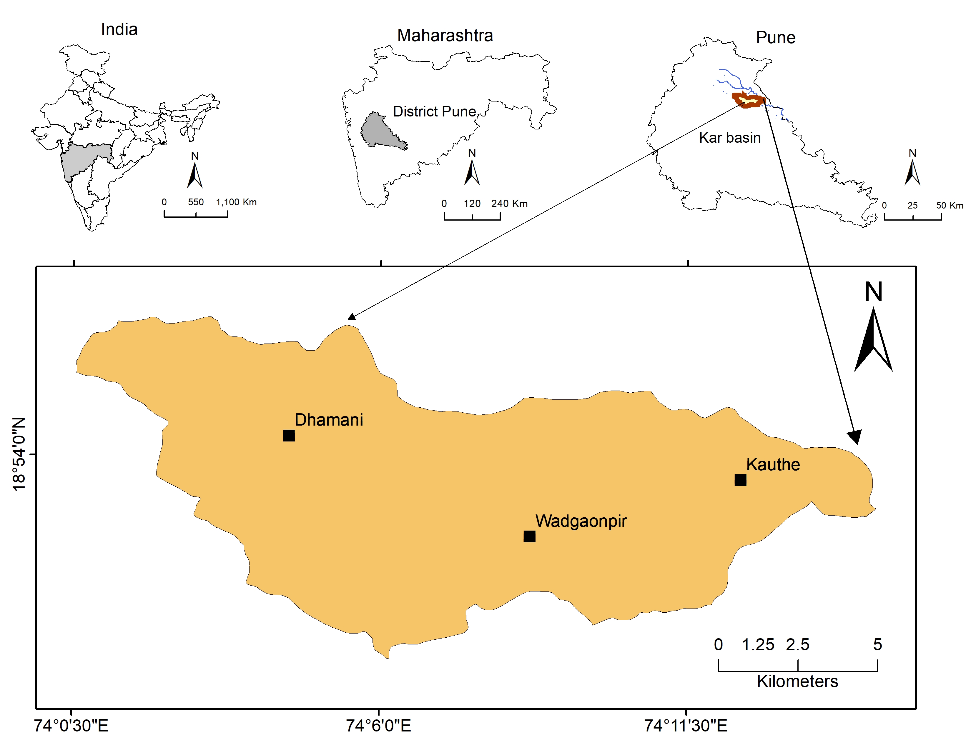
The Kar basin stretches over an area of 145 km2 and lies between the 74º 00ʹ 30"E and 74º 17ʹ 00"E longitudes and 18º 48ʹ 30"N and 18º59ʹ 30"N latitudes (Figure 1). The area is comprised of three main variation of basalt namely compact, amygdaloidal and vesicular basalt. The area is a plateau with rounded hills and ridges, which populate the Northwestern quadrant of the study area. The hill with the highest elevation measures 871m while the lowest point of the plateau has an elevation of 561m. The slope varies from the west to east with the hilly area being dominated in the western part of the watershed. The soil is clayey and has a low overall permeability. The area receives 549.6mm of average annual precipitation; which spans across the months from June to September and the average temperature in winter is 18º C, while it plummets to an average of 40 º C during summers.
Agriculture varies depending on the water availability. The areas with water abundance cultivate sugarcane while at other locations onions and legumes are grown. The population of the Shirur taluka is 37111 recorded in 2011 census.
3. Spatial Data And Methodology
The study was carried out using GIS as a prime tool for the virtual representation of the area. Thirty wells were monitored for the water table fluctuation during the pre-monsoon and post-monsoon seasons for validation purpose. This data was integrated into a GIS environment for the generation of a number of thematic layers, which would help to delineate the groundwater prospects map. The thematic layers virtualized comprise of a geology, geomorphology, slope drainage pattern, drainage density, soil and rainfall as well as the database used is given in Table 1. The methodology adopted for the study is given below (Figure 2).
Table 1. Database
|
Data |
Scale |
Layer |
Derived layer |
|
Geomorphology map a |
1: 2,50,000 |
Geomorphology |
Geomorphology |
|
Geological map b |
1: 50,000 |
Geology |
Geology |
|
Topologic maps c |
1: 50,000 |
Drainage |
Drainage density |
|
Soil map d |
1: 2,50,000 |
Soil |
Hydrological soil groups |
|
ASTER GDEM e |
DEM |
Slope |
|
|
Rainfall f |
Tropical Rainfall Measuring Mission (TRMM) database |
Rainfall distribution |
Rainfall distribution |
a National Atlas and Thematic Mapping Organization (NATMO), Kolkata.
b Geological Survey of India (GSI) India.
c Survey of India
d National Bureau of Soil Survey and Land Use Planning (NBSS and LUP), Nagpur.
e NASA’s Land Processes Distributed Active Archive Center (LP DAAC).
f Tropical Rainfall Measuring Mission (TRMM) database.
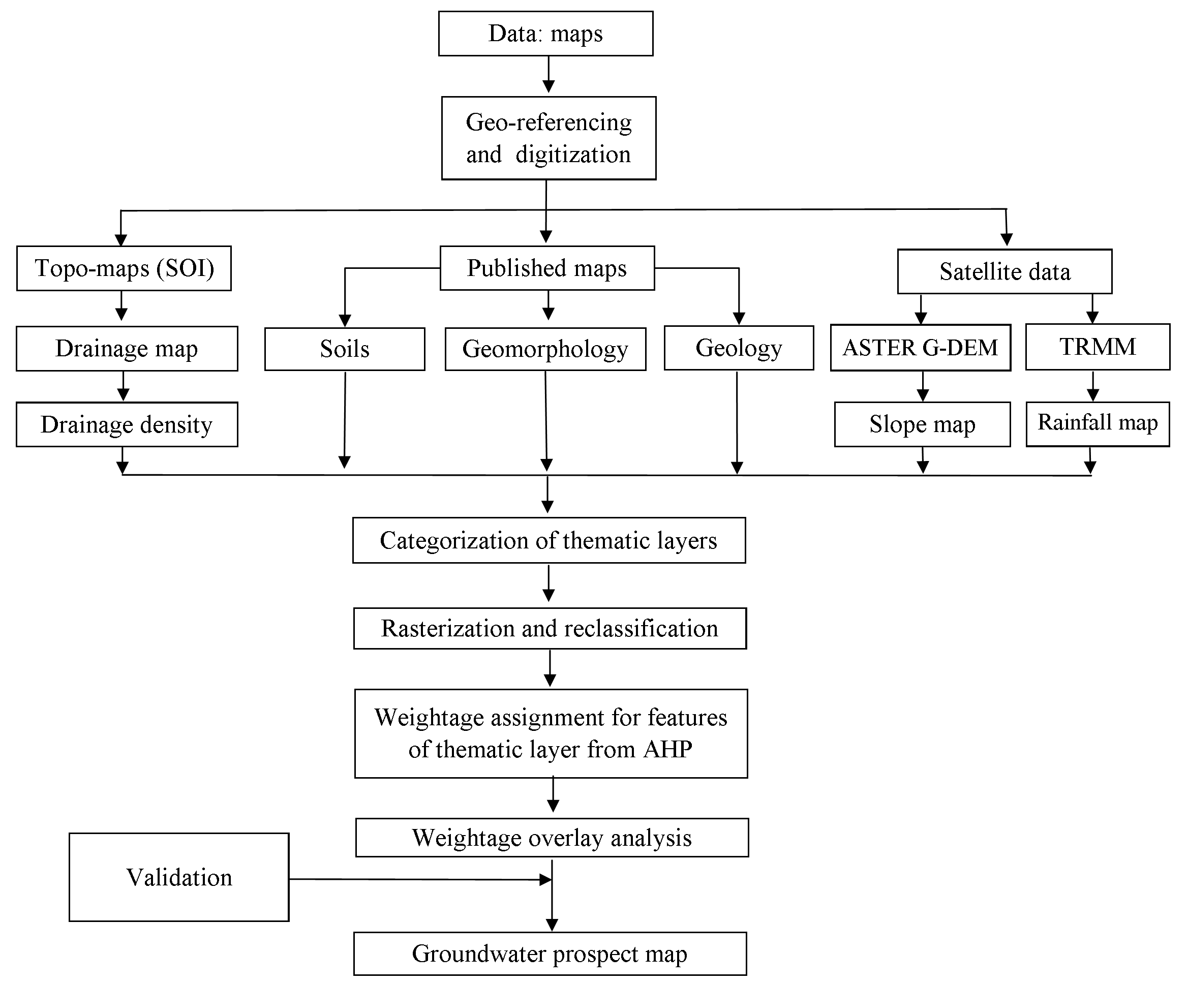
AHP is a model that has been widely used by different researchers in the field of natural resources and environmental management (Kumar and Krishna 2016; Mogaji, 2017). The final weight of each conditioning factor is shown in Table 2. The result of pairwise comparison indicated that the parameters namely aquifer thickness, lithology, water table level, and distance from the river have taken the highest weights. In this study, the CR value is 0.04; the ratio reflects a reasonable level of consistency in the pair-wise comparison phase. For this purpose, each layer mentioned above was converted into a raster format, reclassified and assigned weights from one to three depending on whether the area could
favour the storage of water or no; with one being the least favourable and three being the most. Later all these layers were overlaid and a combined map considering the favourable locations of all the layers is generated (Figure 9). Areas with high gradient will have low potential as there will be a higher runoff. Similarly, areas with dense and compact rocks will have lower potential as water will not percolate. Clayey soil will also not allow water to percolate. Thus, these factors play an important role even if the rainfall is high. Rainfall too is not uniform across the area.
Satellite data like TRMM, Landsat – 8 and ASTER data have been interpreted to derive certain conclusions. The TRMM data gives us the regional variation of rainfall within the basin at a 30 m resolution. It provides valuable input about how much water the area receives as precipitation and its variation. This is an important factor as it determines the main input of the groundwater. The Landsat data was used to study the land use and land cover. These factors are important because, even though the rainfall might be high, the surface should favour its path vertically downward. If the area is a concrete forest there is relatively no permeability in comparison to a green forest. Finally, we have the ASTER data which serves as a digital elevation model. This is another important factor as the permeability is also a function of the slope. The sharper the gradient the more the run off and hence a lower chance of groundwater recharge. Thus, thematic maps are prepared which are basically representations of the data in the form of colors on the map itself. The geomorphic and litho units have been determined via field observations and then co related on the satellite data.
The aquifer is a perched aquifer in hard rock basalt in which most of the porosity is secondary, in the form of cracks, fractures and faults. All the stratigraphic successions are composed of basalt. These basalts vary in types like vesicular, amygdaloidal and compact. Thus, in each of these cases, the potential is low and the strata have only been distinguished as the various impulses as flows. In vesicular basalt too, the vesicles aren’t or seldom connected, so the potential doesn’t increase much anyway (Table 1).
3.1 Geology
In the Deccan Volcanic Province, the majority of the area is comprised of basalt. The basalt is compact at most locations while amygdaloidal basalt is encountered seldom. A mafic dyke is seen cross-cutting one of the good sections in the central area. Fractures and joints, both vertical and horizontal in nature are frequently seen in the basalt (Figure 3). The geological was obtained from Geological Survey of India (GSI).
3.2 Geomorphology
Majority of the area is a remnant plateau of the gigantic Deccan Volcanic Province. The other dominating morphology is of rounded hills and ridges, which occupy the Northwestern quadrant of the study area. Considering all the local geomorphological features, the area exhibits a Highly Dissected Plateau (PHD), Moderately Dissected Plateau (PMD), Slightly Dissected Plateau (PSD), Undissected Plateau (PLU), Weathered Plateau (PW), Shallow-Weathered Plateau, Buttes (B) and Escarpments (ES) (Figure 4).
3.3 Slope
The slope (percent) of the area is generated from the DEM which has a resolution of 30 m (Figure 5). The area is divided into 5 slope classes (IMSD, 1995). ‘Gentle’ class is assigned to the areas having 0-3% slope, and as flat terrain promotes higher infiltration, it is the most important of the slope classes. ‘Moderate’ class denotes areas with 3-10% slope, which signifies a slightly undulating topography with some runoff. The geology of area also influences the amount of runoff and infiltration. A slope of 10-15% will lead to relatively high runoff and low infiltration and fall under the ‘moderately strong’ class. A slope between 15-35% will fall under the ‘strong’ class and ultimately, areas with slope >35% are considered as ‘steep’ as they majorly contribute to runoff even if the subsurface geology is favourable.Each of these units were prioritized while creating the groundwater prospects map by using AHP which is described further.
3.4 Drainage Density
Drainage density is defined as the closeness of spacing of stream channels per unit area. The drainage density of the area has a direct relation with the topography, the geomorphology, the subsurface geology and the land use in the area. Five classes are created to depict the variation in the drainage density. The classes assigned are ‘low’ (0-0.97 km/km2), ‘moderate’ (0.98-2.21 km/km2), ‘moderately high’ (2.21 -3.28 km/km2), ‘high’ (3.29-4.25 km/km2) and ‘very high’ (4.26-5.74 km/km2) respectively (Figure 6). Deriving drainage density and its relation to surface runoff and rock permeability help in delineating groundwater potential zones.
3.5 Soil
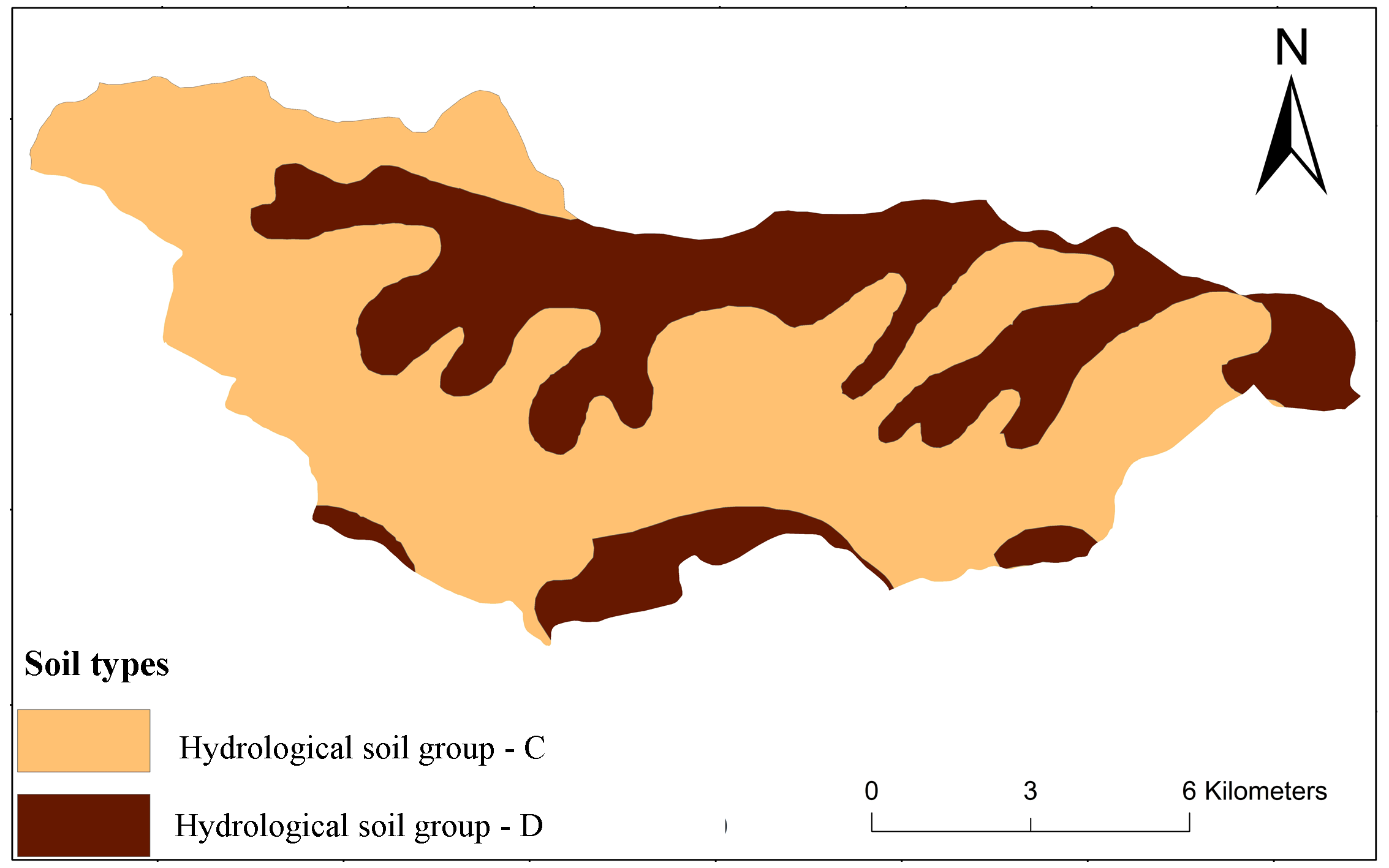
A well-defined soil horizon is developed at most locations. The soil is reddish brown in colour and frequently exhibits mud cracks. This justifies the semi-arid climate of the area. The soil map was acquired from Soil Atlas and Soil Characteristic data from Natural Bureau of Soil Survey and Land Use Planning (NBSS and LUP) Nagpur. According to the soil classification, the soil is of two types i.e. clay loam and clay. Majority of the soil is of clay loam, while we encounter clay along the riverbank. These represent Hydrological Soil Group - C and Hydrological Soil Group – D respectively (Figure 7).
3.6 Rainfall
The rainfall data of the study area was acquired the from Tropical Rainfall Measuring Mission (TRMM) satellite, which has a resolution of 0.5º grid. The data were further classified into five classes using natural breaks method to determine the rainfall distribution of area. The rainfall varies from 690 mm to 840 mm (Figure 8).
3.7 Analytical Hierarchy Process (AHP)
The AHP was used for groundwater prospects mapping in the study area. This approach allows the user for group management, where the researcher can use their scientific knowledge and understanding to solve a problem as a hierarchy structure. It allows the user to remove the biasness by using following six steps 1) outline the unstructured aim and objectives, 2) define the complete conditions and options, 3) use pairwise comparisons between the influencing parameter to prepare comparison matrices, 4) Use the eigenvalue method to define the comparative weights of the influencing parameter, 5) Normalization of weights by dividing sum of total weights of column and 6) Compute the consistency index of the matrices and obtain an overall rating for the alternatives.
With the purpose of defining the weight of each influencing parameter, judgment ratings based on Saaty’s 1–9 scale (Saaty, 2008) were prepared and filled by several experts (hydrologist, hydrogeologists, etc.). Consequently, all the groundwater-influencing parameters were compared against each other in a pairwise comparison matrix. The following equation is used to compute the consistency ratio (\(CR\)).
\(CR = {CI \over RI}\) (1)
Where, \(RI\) is the random index whose value depending on the influencing parameter; and \(CI\) is the consistency index, which is calculated by the following equation,
\(CI = {(\lambda \ max -n)/(n-1)}\) (2)
3.8 Definition of the GWPMI
The groundwater prospects mapping index (\(GWPMI\)) is a unitless quantity that is applied to perform the groundwater potential mapping in the study area. It is calculated using following equation.
\(GWPMI = \sum_{w=1}^{m} \sum_{i=1}^{n} W_i X_j\) (3)
WhereWi is the AHP percent normalized weights of the influencing parameter (thematic layer), \(X_j\) is the rank assigned to each sub-criteria respect to the jth layer, m is the total number of influencing parameter, and n is the total number of sub-criteria of that thematic layer. The values for all layers are given by the equation below,
\(GWPMI-Gmw\ Gmwf+Gew\ Gewf+Sw\ Swf+Ddw\ Ddwf+Rfw\ Rfwf+Slw\ Slwf\) (4)
\(GWPMI\) is the groundwater prospects mapping index for each pixel, \(Gm\) is the Geomorphology, \(Ge\) is geology, \(S\) is the Soil, \(Dd\) is the drainage density, \(Rf\) is the rainfall and \(Sl\) is the Slope. \(GWPMI\) values were grouped into three classes; namely, low, moderate and high where the natural breaks classification method was used in order to prepare the groundwater prospect map.
3.9 Validation
The groundwater flictuation data of 30 wells were used for the validation of study (Figure 9). Low groundwater fluctuation (GWF) depicts high groundwater potential, similarly, high GWF shows low groundwater prospect. The accuracy was assessed by using the following formula:
Accuracy of High GWP (%) = (Wells with low GWF in High GWP zone) / (Total number of wells with low GWF) (5)
Table 2. Random index values
|
N |
1 |
2 |
3 |
4 |
5 |
6 |
7 |
8 |
9 |
10 |
|
RI |
0 |
0 |
0.58 |
0.9 |
1.12 |
1.24 |
1.32 |
1.41 |
1.46 |
1.49 |
4. Result And Discussion
4.1 Spatial analysis
The groundwater prospects map is the base of the development, planning and management of the watershed (Deepika et al. 2013; Abuzied and Alrefaee 2017; Singh et al. 2017b). The groundwater prospects map of the study was derived by performing a weighted overlay analysis of the hydrogeological and geospatial layers such as geomorphology, soil, drainage density, rainfall, geology and slope. The geomorphology of the area has a direct relation to the subsurface movement of water (Avinash et al. 2011). The geomorphology is the aspect which defines the GWP by its characteristic shape (Chowdary et al. 2009). The geomorphology of the study area depicts a weathered plateau which accounts for 15.61% of the area and contributes towards high groundwater prospect. A shallow weathered plateau, that spans across the Northwest to the Southwest region and accounts for 13.12% of the area, denotes a moderately high groundwater prospect. This was followed by an undissected plateau which traces an area of 6.6%, having moderate GWP. The major part of the study was a dissected (56.6%) plateau and was assigned low ranking in the GWP. Buttes and Escarpments were present on the periphery of the study area and cover 8.01% of the study area, holding the lowest GWP.
The study area falls in a basaltic hard-rock terrain and comprises mainly of three litho units. Of these units, the vesicular basalt has the highest GWP (Limaye, 2010) and covers 27.34% of the study area. It is followed by amygdaloidal basalt, which covers 48.14% of the area and is seen in the central portion and the western boundary of the study area. The compact basalt is the third as last lithounit which holds the lowest GWP and covers 24.52% of the total area.
The runoff of the area is a direct product of the slope (Kadam et al. 2012; Singh et al., 2017). The higher the slope more the runoff and hence poor percolation of water. A steep slope will contribute to maximum runoff and hence lowest GWP.51.43% of the area is moderately steep and spans across the northwestern, southwestern and parts of the southeastern quadrant. The result shows that GWP is low this area. A gentle gradient is seen only across 11.01% of the area, which spans across the north-eastern quadrant. Areas with slopes Moderately Strong, Strong and Steep populate 18.43%, 16.07% and 3.06% of the area respectively.
Rainfall is the primary source for recharge of groundwater (Huang et al. 2013; Oikonomidis et al. 2015; Senanayake et al. 2015), it holds prime importance in the delineation of the GWP. A lack of rain directly implies that there exists no water to percolate below, irrespective of the other factors considered. The area has a variation in rainfall and hence it is classified into five classes namely: Very High (711-843 mm), High (682-711 mm), Moderate (640-682 mm), Low (583-640 mm), Very Low (<583 mm). 52.23 % of the area receives high rainfall and is dominated in the central region. The Eastern quadrant receives the heaviest rainfall, which spans across an area of 17.87%. 15.12% of the area has moderate rainfall while 7.48 % has low and 7.29% has very low rainfall. All these three classes correspond the regions with moderately strong, strong and steep slopes in the area; and it shows low GWP
4.2 Groundwater Prospects Mapping
Multi-criteria decision-making (MCDM) based AHP method, which concerns about multiple conflicting criteria can be formally incorporated into the management and planning processes (Agarwal and Garg 2015; Mogaji 2016). A groundwater potential map is prepared by creating a weighed overlay of the thematic layers of geomorphology, geology, drainage density, soil, slope and rainfall (Table 3, 4 and 5).
Table 3. Pairwise comparison matrix
|
Geomorphology |
Geology |
DD |
Soil |
Slope |
Rainfall |
|
|
Geomorphology |
1.00 |
2.00 |
3.00 |
3.00 |
3.00 |
0.14 |
|
Geology |
0.50 |
1.00 |
0.33 |
0.33 |
0.20 |
0.20 |
|
Drainage density |
0.33 |
3.00 |
1.00 |
0.25 |
0.20 |
0.33 |
|
Soil |
0.33 |
3.00 |
4.00 |
1.00 |
3.00 |
0.20 |
|
Slope |
0.33 |
5.00 |
5.00 |
0.33 |
1.00 |
0.20 |
|
Rainfall |
7.00 |
5.00 |
3.00 |
5.00 |
5.00 |
1.00 |
Table 4. Normalization of weights
|
Geomorphology |
Geology |
DD |
Soil |
Slope |
Rainfall |
Weightage |
Avg. Weight |
|
|
Geomorphology |
0.105 |
0.105 |
0.184 |
0.303 |
0.242 |
0.069 |
1.01 |
0.126 |
|
Geology |
0.053 |
0.053 |
0.020 |
0.034 |
0.016 |
0.096 |
0.27 |
0.034 |
|
Drainage density |
0.035 |
0.158 |
0.061 |
0.025 |
0.016 |
0.160 |
0.46 |
0.057 |
|
Soil |
0.035 |
0.158 |
0.245 |
0.101 |
0.242 |
0.096 |
0.88 |
0.110 |
|
Slope |
0.035 |
0.263 |
0.306 |
0.034 |
0.081 |
0.096 |
0.81 |
0.102 |
|
Rainfall |
0.737 |
0.263 |
0.184 |
0.504 |
0.403 |
0.482 |
2.57 |
0.322 |
Table 5. Weights and ranks assigned as per the influence of parameters and their categories derived using AHP
|
Sr. No |
Criterion |
Sub-criterion |
Rank |
Weight |
|
1) |
Geomorphology |
Plateau Undissected(PLU) Plateau shallow-weathered(PLSW) Plateau weathered(PLW) Plateau highly+ moderate+ shallow dissected (PLH+PLM+PLS) Butte+Escarpment(B+Es) |
5 4 3 2 1 |
0.126 |
|
2) |
Geology |
Vesicular Basalt Amygdaloidal Basalt Compact Basalt Intrusion(Dyke) |
5 3 2 1 |
0.034 |
|
3) |
Drainage Density |
Low (0.0 -0.97 km/km2) Moderate (0.98 -2.21 km/km2) Moderately high (2.22 - 3.28 km/km2) High (3.29 – 4.25 km/km2) Very high (4.26 – 5.74 km/km2) |
5 4 3 2 1 |
0.057 |
|
4) |
Soil |
loamy (HSG –B) Clay loam (HSG – C) Clay (HSG – D) |
5 3 1 |
0.11 |
|
5) |
Slope % |
Gentle (0-3%) Moderate (3-10%) Moderate strong (10-15$) Strong (15-35%) Steep (>35%) |
5 4 3 2 1 |
0.102 |
|
6) |
Rainfall |
Very high (711-843 mm) High (682-711 mm) Moderate (640-682 mm) Low (583-640 mm) Very Low (<583 mm) |
5 4 3 2 1 |
0.322 |
4.3 Validation of groundwater potential maps
The resultant groundwater potential map was validated by superimposing the groundwater fluctuation data. The high groundwater level fluctuation is observed in areas of low potential and the vice versa for the areas of high potential. The accuracy percentage of the resultant map is given in the following table (Table 6). The accuracy of the high potential zone delineated is 75% as 3 out of the 4 wells lying in the high potential zone have low fluctuation. Similarly, 10 of the 12 wells in low groundwater potential zone have high groundwater fluctuation hence the accuracy of the zone is 83.33%. (Figure 10).
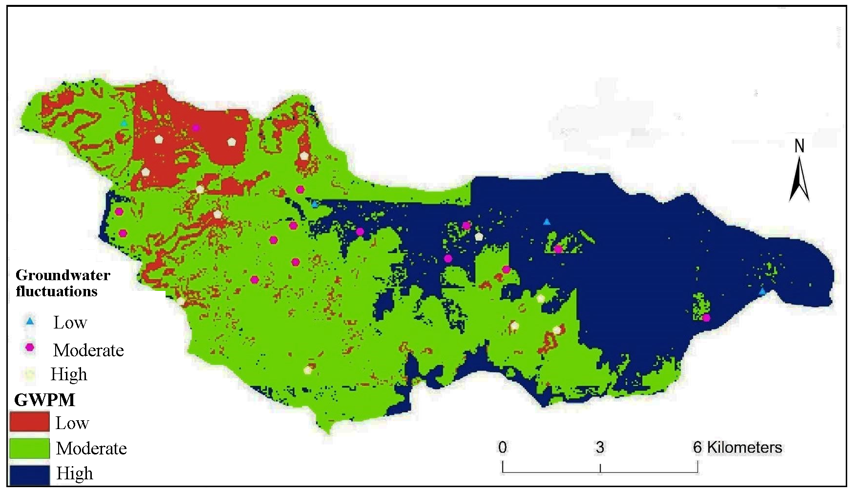
This resultant map will be useful for identification of favourable zones for groundwater exploration, which is further used for watershed development purpose.
Table 6. Accuracy assessment of GWPM
|
Total Wells |
% Accuracy |
|||
|
GWPM class |
Low GWF |
Moderate GWF |
High GWF |
|
|
High |
3 |
1 |
0 |
75.00 % |
|
Moderate |
2 |
11 |
1 |
78.57 % |
|
Low |
1 |
1 |
10 |
83.33 % |
GWF: Groundwater Fluctuations
5. Conclusions
Geomorphological, Geospatial data provided important terrain information to identify various lithological unit and lineaments. These features assisted as supplementary indicators of groundwater occurrence. The study area being semiarid in nature depicts very less percentage of very high groundwater potential. Hence, it has been classified into three classes namely high, moderate and low potential. Majority of the area has a moderate groundwater potential and is dominated in the central region. The mouth of the river is towards the northeast quadrant and hence has a high groundwater potential. The northwest part is hillier with a higher gradient and hence has a lower potential. However, some pockets of high potential are observed in the northwestern quadrant.
Thus, the implementation of integrated GIS-AHP tool proves to be reliable and establishes the accuracy of the technique for groundwater prospects mapping that can be used for other regions having a similar geotectonic setting. The resultant map can be used by watershed developer and planners for watershed development purpose. This map is also used for the construction of rainwater harvesting structure to increasing the water table of the basin.
Conflict of interest
The authors declare no conflict of interest.
Acknowledgements
The authors are thankful to Head, Department of Geology and Head Department of Environmental Sciences, Savitribai Phule Pune University, for providing computing facilities.
Abbreviations
AHP: Analytical hierarchy process; ASTER: Advanced Spaceborne Thermal Emission and Reflection Radiometer; CR: Consistency Ratio; DEM: Digital Elevation Model; GIS: Geographic Information System; GWF: Groundwater Fluctuation; GWP: Groundwater Potential; GWPM: Groundwater Prospects Map; GWPMI: Groundwater Potential Mapping Index; HSG: Hydrological Soil Group; IMSD: Integrated Mission for Sustainable development; MCDM: Multi-criteria Decision Making; NBSS and LUP: Natural Bureau of Soil Survey and Land Use Planning; RS: Remote Sensing; SMA: Soil Moisture Accounting; TRMM: Tropical Rainfall Measuring Mission.
Article information
- Received
- 6 Mar 2018
- Revised
- 29 Apr 2018
- Accepted
- 1 May 2018
- Published
- 28 Jun 2018
- Handling editor
- Dr. Pramodkumar Hire
- Licence
- CC BY-NC-ND 4.0
- Journal
- Hydrospatial Analysis, ISSN 2582-2969
References
-
Abuzied, S. M. and Alrefaee, H. A., 2017. Mapping of groundwater prospective zones integrating remote sensing, geographic information systems and geophysical techniques in El-Qaà Plain area, Egypt. Hydrogeol J, 25(7) 2067–2088.
Crossref -
Adham, A., Riksen, M., Ouessar, M. and Ritsema, C., 2016. Identification of suitable sites for rainwater harvesting structures in arid and semi-arid regions: A review. Int Soil Water Conserv Res.. 4, 108-120.
Crossref -
Agarwal, R. and Garg, P. K., 2015. Remote Sensing and GIS Based Groundwater Potential & Recharge Zones Mapping Using Multi-Criteria Decision Making Technique. Water Resour Manag, 1, 243-260.
Crossref -
Al-Abadi, A. M., 2015. Modeling of groundwater productivity in northeastern Wasit Governorate, Iraq using frequency ratio and Shannon’s entropy models. Appl Water Sci., 7(2), 699-716.
Crossref -
Alizadeh, M. R., Nikoo, M. R., Rakhshandehroo, G. R., 2017. Hydro-environmental management of groundwater resources : A fuzzy-based multi-objective compromise approach. J Hydrol, 551, 540-554.
Crossref -
Ammar, A., Riksen, M., Ouessar, M., Ritsema, C. 2016. Identification of suitable sites for rainwater harvesting structures in arid and semi-arid regions: A review. Int Soil Water Conserv Res. 4(20), 108-120.
Crossref -
Avinash, K., Jayappa, K. S., Deepika, B., 2011. Prioritization of sub-basins based on geomorphology and morphometricanalysis using remote sensing and geographic informationsystem (GIS) techniques. Geocarto Int., 26, 569-592.
Crossref -
Babu, K. J, Sreekumar, S., Aslam, A. and Midhun, K. P., 2014. Hypsometry and geomorphic development of a watershed : A case study from South India. International Journal of Science and Research (IJSR), 3, 1495-1500.
-
Batchelor, C. H., Rao, M. S. R. M. and Rao, M. S., 2003. Watershed development: A solution to water shortages in semi-arid India or part of the problem? Land Use and Water Resources Research, 3, 1-10.
-
Bouma, J., Soest, D. and Van, Bulte, E. 2007. How sustainable is participatory watershed development in India ?, Agricultural Economics, 36, 13-22.
-
Calder, I., Gosain, A. and Rao, M. S. R. M, Charles, B., Garratt, J. and Bishop, E., 2008. Watershed development in India. 2. New approaches for managing externalities and meeting sustainability requirements. Environ Dev Sustain, 10, 427-440.
Crossref -
Chowdary, V. M, Ramakrishnan, D., Srivastava, Y. K., Chandra, V. and Jeyaram, A., 2009. Integrated Water Resource Development Plan for Sustainable Management of Mayurakshi Watershed, India using Remote Sensing and GIS. Water Resour Manag., 23, 1581-1602.
Crossref -
Deepika, B., Avinash, K. and Jayappa, K. S., 2013. Integration of hydrological factors and demarcation of groundwater prospect zones: Insights from remote sensing and GIS techniques. Environ Earth Sci., 70, 1319-1338.
Crossref -
Dhakate, R. and Rao, V. V. S. G., 2012. Integrated Approach for Identifying Suitable Sites for Rainwater Harvesting Structures for Groundwater Augmentation in Basaltic Terrain. Water Resources Management, 27(5), 1279-1299.
Crossref -
Gaikwad, R. and Bhagat V., 2017. Multi-Criteria Watershed Prioritization of Kas Basin in Maharashtra India: AHP and Influence Approaches. Hydrospatial Analysis, 1(1), 41-61.
Crossref -
Gashaw, T., Tulu, T., Argaw, M. and Worqlul, A. W., 2018. Modeling the hydrological impacts of land use/land cover changes in the Andassa watershed, Blue Nile Basin, Ethiopia. Sci. Total Environ, 619–620, 1394–1408.
Crossref - Crossref
-
Huang, C.-C., Yeh, H. F., Lin, H. I., Lee S., Hsu K. and Lee C., 2013. Groundwater recharge and exploitative potential zone mapping using GIS and GOD techniques. Environ Earth Sci 68, 267-280.
Crossref -
Jha, M. K., Chowdary, V. M., Kulkarni, Y. and Mal, B. C., 2014. Rainwater harvesting planning using geospatial techniques and multicriteria decision analysis. Resour Conserv Recycl, 83, 96-211.
Crossref -
Kadam, A. K., Kale, S. S., Pande, N. N., Sankhua R. N., and Pawar N. J., 2012. Identifying potential rainwater harvesting sites of a semi-arid, basaltic region of western india, using scs-cn method. Water Resour Manag, 26, 2537-2554.
Crossref -
Kadam, A., Karnewar, A. S., Umrikar, B. and Sankhua, R. N., 2018, Hydrological response-based watershed prioritization in semiarid, basaltic region of western India using frequency ratio, fuzzy logic and AHP method. Environ Dev Sustain. 1-25.
Crossref -
Kumar, A. and Krishna, A. P., 2016. Assessment of groundwater potential zones in coal mining impacted hard-rock terrain of India by integrating geospatial and analytic hierarchy process ( AHP ) approach. Geocarto Int., 33, 105-129.
Crossref -
Kumar, P. K. D., Gopinath, G. and Seralathan, P., 2017 Application of remote sensing and GIS for the demarcation of groundwater potential zones of a river basin in Kerala, Southwest coast of India. International Journal of Remote Sensing, 28(24), 5583–5601.
Crossref -
Limaye, S. D., 2010. Revue: Exploitation et gestion des eaux souterraines dans les Trapps du Deccan (basaltes) de l’Inde occidentale. Hydrogeol J., 18, 543–558.
Crossref -
Magesh, N. S., Chandrasekar, N. and Soundranayagam, J. P., 2012. Delineation of groundwater potential zones in Theni district, Tamil Nadu, using remote sensing, GIS and MIF techniques. Geoscience Frontiers, 3(2) 189-196.
Crossref -
Mahmoud, S. H. and Alazba, A. A., 2016. Delineation of potential sites for rainwater harvesting structures using a geographic information system-based decision support system. Hydrology Research, 46 (4) 591-606.
Crossref -
Mahmoud, S. H., Alazba A. A., and Amin M. T., 2014. Identification of Potential Sites for Groundwater Recharge Using a GIS-Based Decision Support System in Jazan Region-Saudi Arabia. Water Resour Manag, 28, 3319-3340.
Crossref -
Mandal, U., and Sahoo, S., 2016. Delineation of Groundwater Potential Zones of Coastal Groundwater Basin Using Multi-Criteria Decision Making Technique. Water Resour Manag., 30(12), 4293-4310.
Crossref -
Meenu, R., Rehana, S. and Mujumdar, P. P., 2012. Assessment of hydrologic impacts of climate change in Tunga – Bhadra river basin , India with HEC-HMS and SDSM. Hydrological Processes, 27(11), 1572-1589.
Crossref -
Mekuriaw, A., Heinimann, A., Zeleke, G., Hurni H., and Hurni K., 2017. An automated method for mapping physical soil and water conservation structures on cultivated land using GIS and remote sensing techniques. J Geogr Sci, 27, 79-94.
Crossref -
Mogaji, K. A., 2016. Combining geophysical techniques and multi-criteria GIS-based application modeling approach for groundwater potential assessment in southwestern Nigeria. Environ Earth Sci, 75, 1-20.
Crossref -
Mogaji, K. A., 2017. Development of AHPDST Vulnerability Indexing Model for Groundwater Vulnerability Assessment Using Hydrogeophysical Derived Parameters and GIS Application. Pure Appl Geophys, 174, 1787-1813.
Crossref -
Mondal, S. and Garg, A. C. Pandey, R. D. and Garg, 2007. Groundwater Prospects Evaluation Based on Hydrogeomorphological Mapping using High Resolution Satellite Images : A Case study in Uttarakhand. Journal of the Indian Society of Remote Sensing, 36, 69-76.
Crossref -
Oh, H., Kim. Y., Choi, J., Park E., and Lee S., 2011. GIS mapping of regional probabilistic groundwater potential in the area of Pohang City , Korea. J Hydrol, 399, 158-172.
Crossref -
Oikonomidis, D., Dimogianni, S., Kazakis, N., Voudouris, K., 2015. A GIS/Remote Sensing-based methodology for groundwater potentiality assessment in Tirnavos area, Greece. J Hydrol, 525, 197-208.
Crossref -
Saaty, T. L., 2008. Decision making with the analytic hierarchy process. Int. J. Serv. Sci., 1, 1-83.
Crossref -
Scanlon, B. R., Reedy, R. C., Stonestrom, D. A., Prudic, D. E. and Dennehy, K. F., 2005. Impact of land use and land cover change on groundwater recharge and quality in the southwestern US. Glob Chang Biol, 11, 1577-1593.
Crossref -
Senanayake, I. P., Dissanayake, DMDOK, Mayadunna, B. B., Weerasekera, W. L., 2015. An approach to delineate groundwater recharge potential sites in Ambalantota, Sri Lanka using GIS techniques. Geosci. Front., 7(1), 115-124.
Crossref -
Singh, L. K., Jha, M. K. and Chowdary, V. M., 2017. Multi-criteria analysis and GIS modeling for identifying prospective water harvesting and artificial recharge sites for sustainable water supply. J. Clean. Prod. 142, 1436-1456.
Crossref -
Singh, W. R., Jain, M. K., 2015. Continuous Hydrological Modeling using Soil Moisture Accounting Algorithm in Vamsadhara River Basin. India. J. Water Resour Hydraul Eng., 4, 398-408.
Crossref -
Singhai, A., Das, S., Kadam A., K., Shukla, J. P., Bundela D. S., and Kalashetty M., 2017. GIS-based multi-criteria approach for identification of rainwater harvesting zones in upper Betwa sub-basin of Madhya Pradesh, India. Environ Dev Sustain, 1-21.
Crossref -
Sreedevi, P. D., Subrahmanyam, K. and Ahmed, S., 2005. The significance of morphometric analysis for obtaining groundwater potential zones in a structurally controlled terrain. Environ Geol., 47, 412-420.
Crossref -
Yeh, H., Lin, H., Lee, S., Chang, M., Hsu, K., and Lee, C., 2014. GIS and SBF for estimating groundwater recharge of a mountainous basin in the Wu River watershed, Taiwan. Journal of Earth System Science, 123(3), 503-516.
Crossref -
Zambre, 1983. Unpublished Phd thesis, Hydrogeology of the Shivganga Basin district Pune, Maharashtra
-
Zolekar, R. B., Bhagat, V. S., 2015. Multi-criteria land suitability analysis for agriculture in hilly zone: Remote sensing and GIS approach. Comput Electron Agric, 118:300-321.
Crossref